


CLOSED 8-13-17 FLORIDA/ALABAMA WEATHER
:: Florida Blog
Page 1 of 14 • 1, 2, 3 ... 7 ... 14 ![]()

CLOSED 8-13-17 FLORIDA/ALABAMA WEATHER
![]() by LargoFL Sun Aug 13, 2017 5:14 am
by LargoFL Sun Aug 13, 2017 5:14 am
This Hazardous Weather Outlook is for West Central And Southwest
Florida.
.DAY ONE...Today and Tonight.
...THUNDERSTORM IMPACT...
Thunderstorms during the morning hours will be over the coastal
waters of the Gulf of Mexico, with storms developing onshore by
midday. Higher chances for storms will move further inland with
time during the afternoon and early evening hours. Any storms will
be capable of gusty winds, heavy rainfall, and frequent
lightning...however no organized severe weather is expected. The
main threat from any storms will be localized flooding due to the
slow movement of the storms today.

LargoFL- Posts : 10724
Reputation : 130
Join date : 2017-03-05

LargoFL- Posts : 10724
Reputation : 130
Join date : 2017-03-05
Re: CLOSED 8-13-17 FLORIDA/ALABAMA WEATHER
![]() by LargoFL Sun Aug 13, 2017 5:19 am
by LargoFL Sun Aug 13, 2017 5:19 am
LargoFL- Posts : 10724
Reputation : 130
Join date : 2017-03-05
Re: CLOSED 8-13-17 FLORIDA/ALABAMA WEATHER
![]() by LargoFL Sun Aug 13, 2017 5:35 am
by LargoFL Sun Aug 13, 2017 5:35 am
LargoFL- Posts : 10724
Reputation : 130
Join date : 2017-03-05
Re: CLOSED 8-13-17 FLORIDA/ALABAMA WEATHER
![]() by StAugustineFL Sun Aug 13, 2017 6:50 am
by StAugustineFL Sun Aug 13, 2017 6:50 am
LargoFL wrote:folks around the 22nd-23rd we need to watch carefully this new wave that came off Africa..most models develop it and have it near florida....way too early yet to believe but..we Are coming up to the peak of season and it seems things will be getting very active, tropics wise.
Morning Largo and all.
My cloud did produce a little yesterday. Got .11 out of it. It's rained 9 of 12 days but generally the nickel/dime variety with a total of 1.86"
We have TD8 but it is of no threat.
Yeah, that wave will bear watching. GFS, Euro, CMC all develop it and have it taking the low road. They are also eerily close on placement being 10 days out. Here is each model at 240 hours.
CMC

GFS

Euro


StAugustineFL- Posts : 2231
Reputation : 64
Join date : 2012-07-17
Re: CLOSED 8-13-17 FLORIDA/ALABAMA WEATHER
![]() by sangria Sun Aug 13, 2017 7:05 am
by sangria Sun Aug 13, 2017 7:05 am
Hmm... Those models on that wave are kind of interesting, where is our shear dammit!!

sangria- Admin
- Posts : 2345
Reputation : 55
Join date : 2012-07-16
Re: CLOSED 8-13-17 FLORIDA/ALABAMA WEATHER
![]() by StAugustineFL Sun Aug 13, 2017 7:13 am
by StAugustineFL Sun Aug 13, 2017 7:13 am
sangria wrote:Good Morning everyone! I ended up with 1" in the bucket yesterday. I was hoping for more early AM rains to cool the air down here. I enjoyed working in the yard yesterday after the rain stopped.
Hmm... Those models on that wave are kind of interesting, where is our shear dammit!!
I give to you The Chart.

StAugustineFL- Posts : 2231
Reputation : 64
Join date : 2012-07-17
Re: CLOSED 8-13-17 FLORIDA/ALABAMA WEATHER
![]() by StAugustineFL Sun Aug 13, 2017 7:46 am
by StAugustineFL Sun Aug 13, 2017 7:46 am

Just exiting Africa and looking good.

StAugustineFL- Posts : 2231
Reputation : 64
Join date : 2012-07-17
Re: CLOSED 8-13-17 FLORIDA/ALABAMA WEATHER
![]() by JRnOldsmar Sun Aug 13, 2017 9:07 am
by JRnOldsmar Sun Aug 13, 2017 9:07 am
StAugustineFL wrote:sangria wrote:
Amen Sister!!!
I couldn't stand by and let this go. I fixed it for ya.

JRnOldsmar- Posts : 828
Reputation : 48
Join date : 2017-03-05
Location : Oldsmar, FL
Re: CLOSED 8-13-17 FLORIDA/ALABAMA WEATHER
![]() by JRnOldsmar Sun Aug 13, 2017 9:10 am
by JRnOldsmar Sun Aug 13, 2017 9:10 am
JRnOldsmar- Posts : 828
Reputation : 48
Join date : 2017-03-05
Location : Oldsmar, FL
Re: CLOSED 8-13-17 FLORIDA/ALABAMA WEATHER
![]() by LargoFL Sun Aug 13, 2017 9:34 am
by LargoFL Sun Aug 13, 2017 9:34 am
yeah Aug especially Billsfan's area to begin with huh..then we would see where its headed..right now GFS has it coming in around the Carolina's I think but way too soon to believe anything..but..its a great time for everyone to check their supplies and prep plans etc.StAugustineFL wrote:LargoFL wrote:folks around the 22nd-23rd we need to watch carefully this new wave that came off Africa..most models develop it and have it near florida....way too early yet to believe but..we Are coming up to the peak of season and it seems things will be getting very active, tropics wise.
Morning Largo and all.
My cloud did produce a little yesterday. Got .11 out of it. It's rained 9 of 12 days but generally the nickel/dime variety with a total of 1.86"
We have TD8 but it is of no threat.
Yeah, that wave will bear watching. GFS, Euro, CMC all develop it and have it taking the low road. They are also eerily close on placement being 10 days out. Here is each model at 240 hours.
CMC
GFS
Euro
LargoFL- Posts : 10724
Reputation : 130
Join date : 2017-03-05
Re: CLOSED 8-13-17 FLORIDA/ALABAMA WEATHER
![]() by LargoFL Sun Aug 13, 2017 9:35 am
by LargoFL Sun Aug 13, 2017 9:35 am
gee already huh..we need to keep a very close eye on this oneStAugustineFL wrote:Our system to watch is now an invest.
Just exiting Africa and looking good.
LargoFL- Posts : 10724
Reputation : 130
Join date : 2017-03-05
Re: CLOSED 8-13-17 FLORIDA/ALABAMA WEATHER
![]() by LargoFL Sun Aug 13, 2017 9:36 am
by LargoFL Sun Aug 13, 2017 9:36 am
LargoFL- Posts : 10724
Reputation : 130
Join date : 2017-03-05
Re: CLOSED 8-13-17 FLORIDA/ALABAMA WEATHER
![]() by LargoFL Sun Aug 13, 2017 9:46 am
by LargoFL Sun Aug 13, 2017 9:46 am

LargoFL- Posts : 10724
Reputation : 130
Join date : 2017-03-05
Re: CLOSED 8-13-17 FLORIDA/ALABAMA WEATHER
![]() by LargoFL Sun Aug 13, 2017 9:48 am
by LargoFL Sun Aug 13, 2017 9:48 am

LargoFL- Posts : 10724
Reputation : 130
Join date : 2017-03-05
Re: CLOSED 8-13-17 FLORIDA/ALABAMA WEATHER
![]() by LargoFL Sun Aug 13, 2017 9:51 am
by LargoFL Sun Aug 13, 2017 9:51 am

LargoFL- Posts : 10724
Reputation : 130
Join date : 2017-03-05
Re: CLOSED 8-13-17 FLORIDA/ALABAMA WEATHER
![]() by LargoFL Sun Aug 13, 2017 9:55 am
by LargoFL Sun Aug 13, 2017 9:55 am
LargoFL- Posts : 10724
Reputation : 130
Join date : 2017-03-05
Re: CLOSED 8-13-17 FLORIDA/ALABAMA WEATHER
![]() by LargoFL Sun Aug 13, 2017 9:56 am
by LargoFL Sun Aug 13, 2017 9:56 am
LargoFL- Posts : 10724
Reputation : 130
Join date : 2017-03-05
Re: CLOSED 8-13-17 FLORIDA/ALABAMA WEATHER
![]() by LargoFL Sun Aug 13, 2017 10:41 am
by LargoFL Sun Aug 13, 2017 10:41 am

LargoFL- Posts : 10724
Reputation : 130
Join date : 2017-03-05
Re: CLOSED 8-13-17 FLORIDA/ALABAMA WEATHER
![]() by LargoFL Sun Aug 13, 2017 10:44 am
by LargoFL Sun Aug 13, 2017 10:44 am
LargoFL- Posts : 10724
Reputation : 130
Join date : 2017-03-05
Re: CLOSED 8-13-17 FLORIDA/ALABAMA WEATHER
![]() by JRnOldsmar Sun Aug 13, 2017 10:49 am
by JRnOldsmar Sun Aug 13, 2017 10:49 am
LargoFL wrote:looks like JR is getting a lil rain right now,still no rain by me so far..maybe later............
Good luck, Largo. 0.6 yesterday morning, half, to an inch, just now.
JRnOldsmar- Posts : 828
Reputation : 48
Join date : 2017-03-05
Location : Oldsmar, FL
Re: CLOSED 8-13-17 FLORIDA/ALABAMA WEATHER
![]() by StAugustineFL Sun Aug 13, 2017 10:57 am
by StAugustineFL Sun Aug 13, 2017 10:57 am
JRnOldsmar wrote:LargoFL wrote:looks like JR is getting a lil rain right now,still no rain by me so far..maybe later............
Good luck, Largo. 0.6 yesterday morning, half, to an inch, just now.
I find it fascinating how quickly the rain can add up with a cell only a few miles wide.
StAugustineFL- Posts : 2231
Reputation : 64
Join date : 2012-07-17
Re: CLOSED 8-13-17 FLORIDA/ALABAMA WEATHER
![]() by BillsfaninSoFla Sun Aug 13, 2017 11:18 am
by BillsfaninSoFla Sun Aug 13, 2017 11:18 am
Thanks Gomey (?) for the invite to the NCAA pool.
BillsfaninSoFla- Posts : 1966
Reputation : 52
Join date : 2017-03-05
Re: CLOSED 8-13-17 FLORIDA/ALABAMA WEATHER
![]() by LargoFL Sun Aug 13, 2017 1:33 pm
by LargoFL Sun Aug 13, 2017 1:33 pm
yeah I guess it also matters how long the cell stays in one place too.StAugustineFL wrote:JRnOldsmar wrote:LargoFL wrote:looks like JR is getting a lil rain right now,still no rain by me so far..maybe later............
Good luck, Largo. 0.6 yesterday morning, half, to an inch, just now.
I find it fascinating how quickly the rain can add up with a cell only a few miles wide.
LargoFL- Posts : 10724
Reputation : 130
Join date : 2017-03-05
Re: CLOSED 8-13-17 FLORIDA/ALABAMA WEATHER
![]() by LargoFL Sun Aug 13, 2017 1:34 pm
by LargoFL Sun Aug 13, 2017 1:34 pm
good morning Billsfan..good luck down there..no rain by me so far.BillsfaninSoFla wrote:Good morning. I wish we'd get some rain today.
Thanks Gomey (?) for the invite to the NCAA pool.
LargoFL- Posts : 10724
Reputation : 130
Join date : 2017-03-05
Re: CLOSED 8-13-17 FLORIDA/ALABAMA WEATHER
![]() by LargoFL Sun Aug 13, 2017 3:17 pm
by LargoFL Sun Aug 13, 2017 3:17 pm
thanks JR,not a drop here by me geeJRnOldsmar wrote:LargoFL wrote:looks like JR is getting a lil rain right now,still no rain by me so far..maybe later............
Good luck, Largo. 0.6 yesterday morning, half, to an inch, just now.
LargoFL- Posts : 10724
Reputation : 130
Join date : 2017-03-05
Re: CLOSED 8-13-17 FLORIDA/ALABAMA WEATHER
![]() by LargoFL Sun Aug 13, 2017 3:18 pm
by LargoFL Sun Aug 13, 2017 3:18 pm

LargoFL- Posts : 10724
Reputation : 130
Join date : 2017-03-05
Re: CLOSED 8-13-17 FLORIDA/ALABAMA WEATHER
![]() by LargoFL Sun Aug 13, 2017 3:19 pm
by LargoFL Sun Aug 13, 2017 3:19 pm
LargoFL- Posts : 10724
Reputation : 130
Join date : 2017-03-05
Re: CLOSED 8-13-17 FLORIDA/ALABAMA WEATHER
![]() by LargoFL Sun Aug 13, 2017 3:28 pm
by LargoFL Sun Aug 13, 2017 3:28 pm
LargoFL- Posts : 10724
Reputation : 130
Join date : 2017-03-05
Re: CLOSED 8-13-17 FLORIDA/ALABAMA WEATHER
![]() by sangria Sun Aug 13, 2017 3:30 pm
by sangria Sun Aug 13, 2017 3:30 pm
JRnOldsmar wrote:StAugustineFL wrote:sangria wrote:
Amen Sister!!!
I couldn't stand by and let this go. I fixed it for ya.

sangria- Admin
- Posts : 2345
Reputation : 55
Join date : 2012-07-16
Re: CLOSED 8-13-17 FLORIDA/ALABAMA WEATHER
![]() by LargoFL Sun Aug 13, 2017 3:32 pm
by LargoFL Sun Aug 13, 2017 3:32 pm
Tropical Weather Outlook
NWS National Hurricane Center Miami FL
200 PM EDT Sun Aug 13 2017
For the North Atlantic...Caribbean Sea and the Gulf of Mexico:
The National Hurricane Center is issuing advisories on Tropical
Depression Eight, located several hundred miles southwest of
Bermuda.
1. An area of disturbed weather located to the southeast of the Cabo
Verde Islands is associated with a tropical wave. The wave is
forecast to merge with a broad area of low pressure located
southwest of the Cabo Verde Islands in a day or two. Environmental
conditions are expected to become more conducive for development of
this system later this week while it moves westward at about
15 mph over the tropical Atlantic.
* Formation chance through 48 hours...low...near 10 percent.
* Formation chance through 5 days...low...30 percent.
LargoFL- Posts : 10724
Reputation : 130
Join date : 2017-03-05
Re: CLOSED 8-13-17 FLORIDA/ALABAMA WEATHER
![]() by LargoFL Sun Aug 13, 2017 3:34 pm
by LargoFL Sun Aug 13, 2017 3:34 pm

LargoFL- Posts : 10724
Reputation : 130
Join date : 2017-03-05
Re: CLOSED 8-13-17 FLORIDA/ALABAMA WEATHER
![]() by BillsfaninSoFla Sun Aug 13, 2017 6:04 pm
by BillsfaninSoFla Sun Aug 13, 2017 6:04 pm
BillsfaninSoFla- Posts : 1966
Reputation : 52
Join date : 2017-03-05
Re: CLOSED 8-13-17 FLORIDA/ALABAMA WEATHER
![]() by StAugustineFL Sun Aug 13, 2017 6:35 pm
by StAugustineFL Sun Aug 13, 2017 6:35 pm
BillsfaninSoFla wrote:I know models change and in this case I hope so!
Amen sister! wink, wink nudge, nudge JR!
StAugustineFL- Posts : 2231
Reputation : 64
Join date : 2012-07-17
Re: CLOSED 8-13-17 FLORIDA/ALABAMA WEATHER
![]() by LargoFL Mon Aug 14, 2017 5:12 am
by LargoFL Mon Aug 14, 2017 5:12 am
This Hazardous Weather Outlook is for West Central And Southwest
Florida.
.DAY ONE...Today and Tonight.
...THUNDERSTORM IMPACT...
Thunderstorms during the morning hours will be over the coastal
waters of the Gulf of Mexico, with storms developing onshore by
midday. Higher chances for storms will move further inland with
time during the afternoon and early evening hours. Any storms will
be capable of gusty winds, heavy rainfall, and frequent
lightning...however no organized severe weather is expected.
LargoFL- Posts : 10724
Reputation : 130
Join date : 2017-03-05
Re: CLOSED 8-13-17 FLORIDA/ALABAMA WEATHER
![]() by LargoFL Mon Aug 14, 2017 5:15 am
by LargoFL Mon Aug 14, 2017 5:15 am
LargoFL- Posts : 10724
Reputation : 130
Join date : 2017-03-05
Re: CLOSED 8-13-17 FLORIDA/ALABAMA WEATHER
![]() by LargoFL Mon Aug 14, 2017 7:06 am
by LargoFL Mon Aug 14, 2017 7:06 am
Tonight: A chance of showers and thunderstorms before 9pm, then a slight chance of showers and thunderstorms after midnight. Partly cloudy, with a low around 81. South wind 5 to 8 mph becoming calm after midnight. Chance of precipitation is 30%.
LargoFL- Posts : 10724
Reputation : 130
Join date : 2017-03-05
Re: CLOSED 8-13-17 FLORIDA/ALABAMA WEATHER
![]() by LargoFL Mon Aug 14, 2017 7:16 am
by LargoFL Mon Aug 14, 2017 7:16 am
LargoFL- Posts : 10724
Reputation : 130
Join date : 2017-03-05
Re: CLOSED 8-13-17 FLORIDA/ALABAMA WEATHER
![]() by waterdipper Mon Aug 14, 2017 8:26 am
by waterdipper Mon Aug 14, 2017 8:26 am
Largo, If a hurricane is coming up here, I leave regardless of strength. You can replace your home and belongings, you can't replace your life or the life of one of your family members. And even if you survive it, why would you put yourself or a loved one through that? It isn't like you are going to protect your property in any form or fashion during a storm. Hopefully we don't have to go through this anytime soon.
waterdipper- Posts : 324
Reputation : 18
Join date : 2017-03-15
Location : Somewhere between Cedar Key, Chiefland and Gainesville
Re: CLOSED 8-13-17 FLORIDA/ALABAMA WEATHER
![]() by LargoFL Mon Aug 14, 2017 9:22 am
by LargoFL Mon Aug 14, 2017 9:22 am
yes your right of course, ive been here just about 40 years now in the same place and ive yet to see a hurricane come right over my house,so I guess what they say about our shield is kinda true..old timers keep saying hurricanes always go somewhere else or..lose their punch before they get here......me myself..i don't want to see a hurricane coming over my house lol..waterdipper wrote:A lot of scattered showers around this weekend and even this AM. However, my shield held on and I only got a trace. Now if the mosquitos would leave I would be thrilled.
Largo, If a hurricane is coming up here, I leave regardless of strength. You can replace your home and belongings, you can't replace your life or the life of one of your family members. And even if you survive it, why would you put yourself or a loved one through that? It isn't like you are going to protect your property in any form or fashion during a storm. Hopefully we don't have to go through this anytime soon.
LargoFL- Posts : 10724
Reputation : 130
Join date : 2017-03-05
Re: CLOSED 8-13-17 FLORIDA/ALABAMA WEATHER
![]() by gomexwx Mon Aug 14, 2017 9:24 am
by gomexwx Mon Aug 14, 2017 9:24 am
LargoFL wrote:I'm wodering,at what strength of hurricane would you..consider evacuating your home??...i'd stick it out thru..oh cat 3 I guess...now a 4-5 i'd have to see if it was forecasted to come right over my area,if so..i'd be watching the news from somewhere north LOL..how about you folks? for myself, I'm not worried at all about storm surge, I'm high enough..its the really strong damaging winds i'm concerned with...no fun being hunkered down in your home with the roof etc being blown off huh..could be..life threatening huh.
I am inland where the surge is a non issue. But I am on a ridge meaning when the beast come's ashore I get slammed since winds increase with altitude. I have been in numerous hurricanes from CAT 1 to CAT 5. When a hurricane becomes a major it don't matter the CAT Number, at any given time these storms can slam you with gust as high as 200mph. A CAT 3-4 did more damage to my house than any of the CAT5s..A CAT 3 put three trees through my walls and roof of a brick home. I stay for all of them but I recommend you leave when a storm reaches CAT3. Remember if you plan to evacuate LEAVE EARLY! or you may ride out a major in a car...NOT GOOD!

gomexwx- Posts : 641
Reputation : 63
Join date : 2012-07-16
Location : On an Acre somewhere on the gulf Coast
Re: CLOSED 8-13-17 FLORIDA/ALABAMA WEATHER
![]() by LargoFL Mon Aug 14, 2017 9:25 am
by LargoFL Mon Aug 14, 2017 9:25 am

LargoFL- Posts : 10724
Reputation : 130
Join date : 2017-03-05
Re: CLOSED 8-13-17 FLORIDA/ALABAMA WEATHER
![]() by LargoFL Mon Aug 14, 2017 9:28 am
by LargoFL Mon Aug 14, 2017 9:28 am

LargoFL- Posts : 10724
Reputation : 130
Join date : 2017-03-05
Re: CLOSED 8-13-17 FLORIDA/ALABAMA WEATHER
![]() by LargoFL Mon Aug 14, 2017 9:32 am
by LargoFL Mon Aug 14, 2017 9:32 am
LargoFL- Posts : 10724
Reputation : 130
Join date : 2017-03-05
Re: CLOSED 8-13-17 FLORIDA/ALABAMA WEATHER
![]() by LargoFL Mon Aug 14, 2017 9:41 am
by LargoFL Mon Aug 14, 2017 9:41 am
LargoFL- Posts : 10724
Reputation : 130
Join date : 2017-03-05
Re: CLOSED 8-13-17 FLORIDA/ALABAMA WEATHER
![]() by LargoFL Mon Aug 14, 2017 9:43 am
by LargoFL Mon Aug 14, 2017 9:43 am
LargoFL- Posts : 10724
Reputation : 130
Join date : 2017-03-05
Re: CLOSED 8-13-17 FLORIDA/ALABAMA WEATHER
![]() by BillsfaninSoFla Mon Aug 14, 2017 2:50 pm
by BillsfaninSoFla Mon Aug 14, 2017 2:50 pm
LargoFL wrote:ok too much from me lol..BBL..
No, it's not too much from you! I look forward to popping in and checking for the updates you provide. I don't know where to look for most of the stuff you post and I don't have the chance to look around for that stuff.
PLEASE keep posting Largo, especially when we have something out there to track.
BillsfaninSoFla- Posts : 1966
Reputation : 52
Join date : 2017-03-05
Re: CLOSED 8-13-17 FLORIDA/ALABAMA WEATHER
![]() by LargoFL Mon Aug 14, 2017 3:41 pm
by LargoFL Mon Aug 14, 2017 3:41 pm
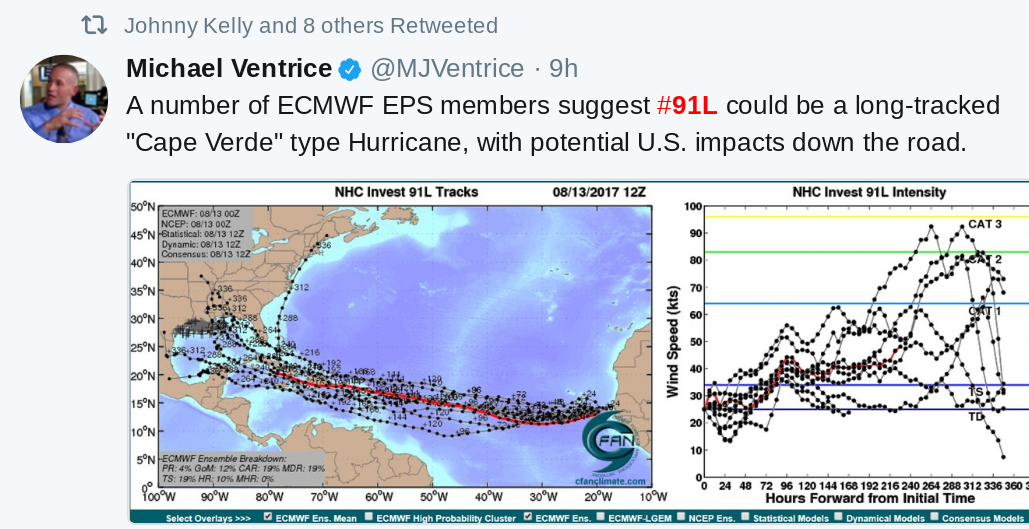
ok thanks and will do, I know most folks here are working thru the daytime hours so I try to keep the blog going, especially in the stormy days. next few weeks tropical wise looks to be very active storm wise..maybe one after the other whew...im really hoping this 91 soon to be Harvey, does what 99L did..recurve back out into the Atlantic..it could be a strong one once it gets close to us.BillsfaninSoFla wrote:LargoFL wrote:ok too much from me lol..BBL..
No, it's not too much from you! I look forward to popping in and checking for the updates you provide. I don't know where to look for most of the stuff you post and I don't have the chance to look around for that stuff.
PLEASE keep posting Largo, especially when we have something out there to track.
LargoFL- Posts : 10724
Reputation : 130
Join date : 2017-03-05
Re: CLOSED 8-13-17 FLORIDA/ALABAMA WEATHER
![]() by LargoFL Mon Aug 14, 2017 3:44 pm
by LargoFL Mon Aug 14, 2017 3:44 pm
NWS National Hurricane Center Miami FL AL092017
500 PM AST Thu Aug 17 2017
An Air Force Reserve Hurricane Hunter aircraft found a well-defined
circulation in the low pressure area east of the Lesser Antilles,
with the center near a cluster of sheared, but strong, convection.
The aircraft data suggest that the maximum winds are near 35 kt
and that the central pressure is near 1004 mb. Based on these
data, the disturbance is upgraded to Tropical Storm Harvey.
The initial motion is 270/16. There is no change to the forecast
philosophy since the previous advisory. A deep-layer ridge to the
north of the system should steer it quickly just north of due west
through the forecast period, with this motion expected to bring the
system through the Lesser Antilles and into the eastern Caribbean
Sea in 12-24 h, into the central Caribbean by 48-72 h, and to the
western Caribbean by 96-120 h. One adjustment is that the 96-120 h
points have been nudged a little southward in response to a shift in
the guidance, and thus now lie closer to Central America than on
the previous forecast. The forecast track again lies near the
center of the tightly clustered guidance envelope and the various
consensus models.
The system is in an area of moderate easterly vertical shear, and
the large-scale models suggest that light/moderate shear should
continue through at least 72 h. The conflicting forecast scenarios
alluded to in the previous advisory remain, with the SHIPS and
LGEM models still showing steady intensification while the GFS and
ECMWF models still forecast degeneration to an easterly wave over
the central Caribbean. The new intensity forecast again follows the
trend of the SHIPS/LGEM models, but it remains on the low side of
the guidance envelope out of respect for the GFS/ECMWF. The 96-120 h
intensities have been decreased a little due to the forecast track
showing more land interaction.
FORECAST POSITIONS AND MAX WINDS
INIT 17/2100Z 13.0N 55.8W 35 KT 40 MPH
12H 18/0600Z 13.1N 58.3W 35 KT 40 MPH
24H 18/1800Z 13.4N 61.6W 40 KT 45 MPH
36H 19/0600Z 13.7N 65.1W 45 KT 50 MPH
48H 19/1800Z 14.0N 68.8W 45 KT 50 MPH
72H 20/1800Z 14.5N 76.5W 55 KT 65 MPH
96H 21/1800Z 15.5N 83.5W 60 KT 70 MPH
120H 22/1800Z 17.0N 88.5W 55 KT 65 MPH...INLAND
$$
Forecaster Beven
Last edited by LargoFL on Thu Aug 17, 2017 5:02 pm; edited 1 time in total
LargoFL- Posts : 10724
Reputation : 130
Join date : 2017-03-05
Re: CLOSED 8-13-17 FLORIDA/ALABAMA WEATHER
![]() by LargoFL Mon Aug 14, 2017 3:46 pm
by LargoFL Mon Aug 14, 2017 3:46 pm
Last edited by LargoFL on Thu Aug 17, 2017 5:03 pm; edited 1 time in total
LargoFL- Posts : 10724
Reputation : 130
Join date : 2017-03-05
Page 1 of 14 • 1, 2, 3 ... 7 ... 14 ![]()
» CLOSED 7-1-17 Florida/Alabama Weather
» CLOSED 4/2/17 Florida/Alabama Weather Blog
» CLOSED 5/29/17 Florida/Alabama Weather Blog
» CLOSED Florida/Alabama Fall Season weather
:: Florida Blog


» summer 2019 hurricane season
» April-May Florida weather and local events etc
» NASCAR 2019
» Late January through February outlook
» FLORIDA/ALABAMA AND THE HOLIDAY SEASON WEATHER
» NASCAR 2018
» CLOSED Florida/Alabama Blog - October Tropical Mischief