


Tropical Storm Ernesto - Severe Weather

Tropical Storm Ernesto - Severe Weather
![]() by emcf30 Thu Aug 02, 2012 8:14 am
by emcf30 Thu Aug 02, 2012 8:14 am
Overnight, Tropical Depression #5 and has showed an significant decrease in the convection, however, recent satellite images morning shows some increase in deeper convection near the center of circulation. This pulsing of convection of convection is normal with any tropical cyclone that is developing, especially one that is just broke free of the ITCZ. Additionally, there is a great deal of shear to the North of TD5 which is having some effect on the system.
Image of TD5 around midnight

Latest Image

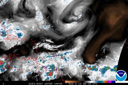
So as you can see convection is beginning to fire around the Center of Circulation once again.
I do think that we will see some slight strengthening over the next 24 to 48 for allow for TD 5 to be upgraded to Tropical Storm Ernesto while over the Windward islands. Barbados will be the first Island to be affected by the storm. Once again, here is the link for the Barbados Weather Service.

And another Radar Link from Meteo France covering the Island chain
Animated Radar Loop- Windward Islands
The current 5 day track from the NHC shows little change other the the strength has been down graded at day 5 to Tropical Storm.

Now, lets look at some models, some which are scary for the Gulf Coast States.
GFS Esemble

GFS Operational ( Look what it shows after TD5)

CMC end result

Euro

The latest end result GFS


Now for the sever weather
A potent upper-level low pressure system will swing south across Canada, crashing into the northern Rockies and western High Plains late this afternoon. The outcome will be a growing line of powerful thunderstorms late this afternoon through tonight. The storms will build in eastern Montana and Wyoming initially, before multiplying and sweeping across the western Dakotas and extreme northern Nebraska this evening.
Here is the SPC's Convective Outlook

Last edited by emcf30 on Thu Aug 02, 2012 4:16 pm; edited 1 time in total

emcf30- Posts : 975
Reputation : 10
Join date : 2012-07-16
Age : 93
Re: Tropical Storm Ernesto - Severe Weather
![]() by sangria Thu Aug 02, 2012 8:28 am
by sangria Thu Aug 02, 2012 8:28 am

sangria- Admin
- Posts : 2345
Reputation : 55
Join date : 2012-07-16
Re: Tropical Storm Ernesto - Severe Weather
![]() by scouter534 Thu Aug 02, 2012 9:07 am
by scouter534 Thu Aug 02, 2012 9:07 am

scouter534- Posts : 128
Reputation : 1
Join date : 2012-07-16
Age : 62
Location : Pompano Beach, FL
Re: Tropical Storm Ernesto - Severe Weather
![]() by emcf30 Thu Aug 02, 2012 10:00 am
by emcf30 Thu Aug 02, 2012 10:00 am

It's alive.........

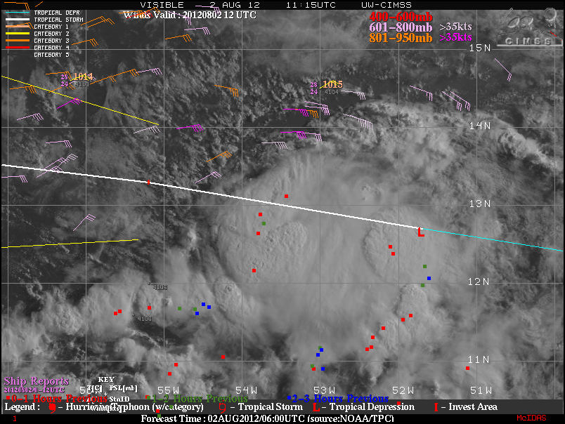
Tracks


Convection starting to wrap around what looks to be the center. Firing
off on the East and Southwest sides

SHIPS intensity estimates are also on the upward swing. The dropped considerably yesterday and last night. Must be picking up on the ripe conditions in the Western portion of the Caribbean for development
* ATLANTIC SHIPS INTENSITY FORECAST *
* GOES AVAILABLE, OHC AVAILABLE *
* FIVE AL052012 08/02/12 12 UTC *
TIME (HR) 0 6 12 18 24 36 48 60 72 84 96 108 120
V (KT) NO LAND 30 31 32 33 36 40 46 49 53 57 64 71 75
V (KT) LAND 30 31 32 33 36 40 46 49 53 57 64 71 75
V (KT) LGE mod 30 30 31 31 32 34 37 41 46 53 63 76 88
Storm Type TROP TROP TROP TROP TROP TROP TROP TROP TROP TROP TROP TROP TROP
SHEAR (KT) 19 18 15 15 12 9 11 5 8 6 7 6 8
SHEAR ADJ (KT) 0 -2 -2 -1 0 -4 0 -1 -6 0 -3 -1 -4
SHEAR DIR 281 270 251 268 269 237 279 232 294 13 353 257 285
SST (C) 27.9 28.1 28.1 28.1 28.1 28.0 28.4 28.4 28.2 28.5 28.5 28.5 28.7
337
WHXX01 KWBC 021248
CHGHUR
TROPICAL CYCLONE GUIDANCE MESSAGE
NWS NATIONAL HURRICANE CENTER MIAMI FL
1248 UTC THU AUG 2 2012
DISCLAIMER...NUMERICAL MODELS ARE SUBJECT TO LARGE ERRORS.
PLEASE REFER TO NHC OFFICIAL FORECASTS FOR TROPICAL CYCLONE
AND SUBTROPICAL CYCLONE INFORMATION.
ATLANTIC OBJECTIVE AIDS FOR
TROPICAL CYCLONE FIVE (AL052012) 20120802 1200 UTC
...00 HRS... ...12 HRS... ...24 HRS. .. ...36 HRS...
120802 1200 120803 0000 120803 1200 120804 0000
LAT LON LAT LON LAT LON LAT LON
BAMS 12.9N 53.4W 13.8N 57.0W 14.4N 60.8W 14.9N 64.5W
BAMD 12.9N 53.4W 13.4N 55.3W 14.1N 57.3W 14.8N 59.2W
BAMM 12.9N 53.4W 13.5N 55.9W 14.1N 58.7W 14.9N 61.5W
LBAR 12.9N 53.4W 13.4N 56.1W 13.7N 59.0W 14.3N 61.8W
SHIP 30KTS 32KTS 36KTS 40KTS
DSHP 30KTS 32KTS 36KTS 40KTS
...48 HRS... ...72 HRS... ...96 HRS. .. ..120 HRS...
120804 1200 120805 1200 120806 1200 120807 1200
LAT LON LAT LON LAT LON LAT LON
BAMS 15.2N 68.5W 15.8N 76.0W 14.9N 81.7W 13.8N 83.5W
BAMD 15.5N 61.2W 16.9N 64.9W 17.5N 68.2W 17.1N 70.6W
BAMM 15.8N 64.5W 17.7N 70.9W 19.5N 77.2W 21.0N 82.3W
LBAR 14.8N 64.6W 16.4N 69.9W 18.4N 75.0W 14.3N 79.8W
SHIP 46KTS 53KTS 64KTS 75KTS
DSHP 46KTS 53KTS 64KTS 75KTS
...INITIAL CONDITIONS...
LATCUR = 12.9N LONCUR = 53.4W DIRCUR = 280DEG SPDCUR = 17KT
LATM12 = 12.4N LONM12 = 49.8W DIRM12 = 282DEG SPDM12 = 17KT
LATM24 = 11.4N LONM24 = 46.7W
WNDCUR = 30KT RMAXWD = 40NM WNDM12 = 30KT
CENPRS = 1008MB OUTPRS = 1013MB OUTRAD = 90NM SDEPTH = M
RD34NE = 0NM RD34SE = 0NM RD34SW = 0NM RD34NW = 0NM
$$
NNNN
emcf30- Posts : 975
Reputation : 10
Join date : 2012-07-16
Age : 93
Re: Tropical Storm Ernesto - Severe Weather
![]() by emcf30 Thu Aug 02, 2012 10:18 am
by emcf30 Thu Aug 02, 2012 10:18 am

But, in a couple of days, much more favorable 250 hPa flow over the western Caribbean.

The lowering of the shear in the furture is the reason for the intensity driven forecast which will ultimately drive where the system goes and whom it impacts. The stronger by the time it reaches the Western Caribbean, ( if it survives the trip ) the more likely for a movement into the GOM
emcf30- Posts : 975
Reputation : 10
Join date : 2012-07-16
Age : 93
Re: Tropical Storm Ernesto - Severe Weather
![]() by gomexwx Thu Aug 02, 2012 10:29 am
by gomexwx Thu Aug 02, 2012 10:29 am

gomexwx- Posts : 641
Reputation : 63
Join date : 2012-07-16
Location : On an Acre somewhere on the gulf Coast
Re: Tropical Storm Ernesto - Severe Weather
![]() by emcf30 Thu Aug 02, 2012 10:31 am
by emcf30 Thu Aug 02, 2012 10:31 am
nvest 99L developed into Tropical Depression #5 yesterday, and has maintained about the same intensity since then. Thunderstorm activity partially covers the center, but is still clearly being limited by wind shear being imposed on the northern side of the circulation by an upper low over the central Atlantic. This wind shear will continue to be a moderate issue for TD 5 over the next few days as the upper trough expands westward a bit to the north of the big Caribbean islands, following TD 5 as it too moves westward. The bigger issue for TD 5 though will be the strong trade wind flow that it is entering. The depression is now moving at 21mph, indicating the increasing flow that it is becoming embedded in, which will make it difficult for its circulation to survive and for thunderstorms to develop over it. This is a typical pattern for the eastern Caribbean that makes this region unfavorable most of the time for developing tropical systems, but especially during El Nino years like this one. Due to this pattern, I don't expect TD 5 to really strengthen at all for the next 3-4 days. It may get named Ernesto, but should remain a very weak tropical storm for the time being, and could even degenerate back into an open wave at some point if it loses the westerlies on the southern side of its circulation. The lesser Antilles will get minimal tropical storm conditions from this starting tomorrow, but not a big deal there.
However, TD 5's best days may lie well ahead of it. If TD 5's circulation survives as a defined entity until it reaches Jamaica, the pattern starts to turn in its favor. Right now there is an upper trough over the northwest Caribbean that won't be moving much over the next 7 days, and neither will the upper trough over the central Atlantic. As TD 5 moves westward, the NW Caribbean upper trough will start backing away to the southwest in front of TD 5, a situation that is almost always favorable, since it allows upper-level ridging to expand over the system and cause light wind shear and divergence aloft that promotes convection and lowering of pressures. The positioning of the TUTT-like trough to the northeast of TD 5 at that time would further improve ventilation of the area in general. The GFS ensemble mean supports this, as I show in the video. Such a pattern could rapidly become conducive for significant strengthening if TD 5 is organized enough to take advantage down the road in the northwest Caribbean and quite possibly the Gulf of Mexico.
As far as the future track goes, much will still depend on how strong TD 5 can get west of Jamaica if it is still alive, but some general ideas can be discussed. The GFS specifically and now the ECMWF have been leaning northwestward with TD 5's track in the long term, and it is worth investigating whether this could make sense. I show in the video how the typhoon pattern in the western Pacific looks like it is connected with this idea, causing amplification in the pattern that ripples downstream and strengthens a trough over the eastern U.S. in 7-10 days that may break down the ridge over the Gulf of Mexico and allow TD 5 to turn northwestward towards the gulf. The strengthening of the eastern trough also looks like it could force the Texas heat ridge far enough back into the Rockies that Texas itself could be open to a hurricane hit in this kind of a situation, but such a pattern leaves everywhere from central America to Louisiana open to a hit, and specifics cannot be known this far in advance.
Overall, TD 5 is no big deal in the near term, and will be directly affecting only the Lesser Antilles as a tropical depression or minimal tropical storm tomorrow and Saturday. Jamaica and the rest of the NW Caribbean may have to deal with TD 5 in 4-6 days, possibly as a restrengthening system of higher caliber than it is now if it survives the trip through the Caribbean and is able to take advantage of what should be a much more favorable pattern for intensification in that area. Interests in the NW Caribbean, central America, and the Gulf of Mexico should keep a wary eye on this situation due to its possible long-range implications.
We shall see what happens!
emcf30- Posts : 975
Reputation : 10
Join date : 2012-07-16
Age : 93
Re: Tropical Storm Ernesto - Severe Weather
![]() by emcf30 Thu Aug 02, 2012 11:35 am
by emcf30 Thu Aug 02, 2012 11:35 am

emcf30- Posts : 975
Reputation : 10
Join date : 2012-07-16
Age : 93
Re: Tropical Storm Ernesto - Severe Weather
![]() by emcf30 Thu Aug 02, 2012 11:45 am
by emcf30 Thu Aug 02, 2012 11:45 am

emcf30- Posts : 975
Reputation : 10
Join date : 2012-07-16
Age : 93
Re: Tropical Storm Ernesto - Severe Weather
![]() by gomexwx Thu Aug 02, 2012 11:58 am
by gomexwx Thu Aug 02, 2012 11:58 am
gomexwx- Posts : 641
Reputation : 63
Join date : 2012-07-16
Location : On an Acre somewhere on the gulf Coast


StAugustineFL- Posts : 2231
Reputation : 64
Join date : 2012-07-17
Re: Tropical Storm Ernesto - Severe Weather
![]() by emcf30 Thu Aug 02, 2012 12:38 pm
by emcf30 Thu Aug 02, 2012 12:38 pm

emcf30- Posts : 975
Reputation : 10
Join date : 2012-07-16
Age : 93
Re: Tropical Storm Ernesto - Severe Weather
![]() by Seawall Thu Aug 02, 2012 12:45 pm
by Seawall Thu Aug 02, 2012 12:45 pm

Seawall- Posts : 125
Reputation : 3
Join date : 2012-07-16
Re: Tropical Storm Ernesto - Severe Weather
![]() by Seawall Thu Aug 02, 2012 12:46 pm
by Seawall Thu Aug 02, 2012 12:46 pm
Seawall- Posts : 125
Reputation : 3
Join date : 2012-07-16
Re: Tropical Storm Ernesto - Severe Weather
![]() by emcf30 Thu Aug 02, 2012 12:47 pm
by emcf30 Thu Aug 02, 2012 12:47 pm
emcf30- Posts : 975
Reputation : 10
Join date : 2012-07-16
Age : 93
Re: Tropical Storm Ernesto - Severe Weather
![]() by emcf30 Thu Aug 02, 2012 12:52 pm
by emcf30 Thu Aug 02, 2012 12:52 pm
emcf30- Posts : 975
Reputation : 10
Join date : 2012-07-16
Age : 93
Re: Tropical Storm Ernesto - Severe Weather
![]() by emcf30 Thu Aug 02, 2012 1:12 pm
by emcf30 Thu Aug 02, 2012 1:12 pm

The latest GFS Esembles show a definite shift to the North. The circles is the range of various members. Some nice products

Here is the link to look at other product available with the above image
http://www.esrl.noaa.gov/psd/forecasts/
emcf30- Posts : 975
Reputation : 10
Join date : 2012-07-16
Age : 93
Re: Tropical Storm Ernesto - Severe Weather
![]() by emcf30 Thu Aug 02, 2012 1:56 pm
by emcf30 Thu Aug 02, 2012 1:56 pm

That southern quadrant flowing into the COC is rather impressive.

Last edited by emcf30 on Thu Aug 02, 2012 3:29 pm; edited 1 time in total
emcf30- Posts : 975
Reputation : 10
Join date : 2012-07-16
Age : 93
Re: Tropical Storm Ernesto - Severe Weather
![]() by sangria Thu Aug 02, 2012 2:34 pm
by sangria Thu Aug 02, 2012 2:34 pm
sangria- Admin
- Posts : 2345
Reputation : 55
Join date : 2012-07-16
Re: Tropical Storm Ernesto - Severe Weather
![]() by sangria Thu Aug 02, 2012 2:53 pm
by sangria Thu Aug 02, 2012 2:53 pm
Product: Air Force Tropical RECCO Message (URNT11 KNHC)
Transmitted: 2nd day of the month at 18:24Z
Aircraft: Air Force Aircraft (Last 3 digits of the tail number are 302)
Tropical Depression: Number 5 (flight in the North Atlantic basin)
Mission Number: 1
Observation Number: 10
Mandatory Data...
Observation Time: Thursday, 18:22Z
Radar Capability: Yes
Aircraft Altitude: Below 10,000 meters
Coordinates: 12.7N 55.3W
Location: 292 miles (470 km) to the E (95°) from Bridgetown, Barbados.
Turbulence: Light
Conditions Along Flight Route: In the clear
Pressure Altitude: 300 meters
Flight Level Wind: From 180° at 21 knots (From the S at ~ 24.1 mph)
- The above is a spot wind.
- Winds were obtained using doppler radar or inertial systems.
Flight Level Temperature: 25°C
Flight Level Dew Point: Not available, probably because the dew point hygrometer was not working.
Weather (within 30 nautical miles): Thunderstorm(s)
Mean Sea Level Pressure (MSLP): 1009 mb (extrapolated)
Optional Data...
Estimated Surface Wind: From 180° at 20 knots (From the S at ~ 23.0 mph)
sangria- Admin
- Posts : 2345
Reputation : 55
Join date : 2012-07-16
Re: Tropical Storm Ernesto - Severe Weather
![]() by emcf30 Thu Aug 02, 2012 3:12 pm
by emcf30 Thu Aug 02, 2012 3:12 pm
The Weather is becoming anything but Dull.
The SPC has modified their Convective outlook for this afternoon.

There is going to be another period of Severe Weather breaking out beginning in Canada and the Northern Plains and moving East during the upcoming weekend. This setup is being caused by a unusual potent disturbance for this time of year and will affect many States and Providences.
A closed upper level low currently located over Canada will transition into a potent shortwave trough this afternoon and evening.


This feature will begin to move across the Northern High Plains and Southern Canada inducing low level cyclogenesis. In response to this, an active severe weather period appears likely for parts of the Northern U.S. and Canada. The first risk for potential severe weather will be this afternoon and evening across the Northern High Plains.
The primary threats today will be large hail and damaging winds. An isolated tornado can’t be ruled out, though the tornado threat overall appears very low today.
For Friday, a stronger area of low pressure will develop at the surface due to the trough’s orientation becoming less positively tilted, and the upper level jet streak will help provide divergence aloft. Tomorrow the risk area will shift to the Dakotas, Minnesota, Southeastern Manitoba and part of Northwestern Ontario. The area from Iowa to Wisconsin, could be in the cross hairs of the nasty storms during Saturday. The environment will be more favorable for tornadoes. Nasty storms could be approaching on the Chicago Metro Saturday evening.

The storm system will continue is move to the East throughout the weekend and a more damaging threat of Tornadoes will occur on Saturday.

emcf30- Posts : 975
Reputation : 10
Join date : 2012-07-16
Age : 93
Re: Tropical Storm Ernesto - Severe Weather
![]() by sangria Thu Aug 02, 2012 3:21 pm
by sangria Thu Aug 02, 2012 3:21 pm
sangria- Admin
- Posts : 2345
Reputation : 55
Join date : 2012-07-16
Re: Tropical Storm Ernesto - Severe Weather
![]() by scouter534 Thu Aug 02, 2012 3:43 pm
by scouter534 Thu Aug 02, 2012 3:43 pm

scouter534- Posts : 128
Reputation : 1
Join date : 2012-07-16
Age : 62
Location : Pompano Beach, FL
Re: Tropical Storm Ernesto - Severe Weather
![]() by Seawall Thu Aug 02, 2012 4:16 pm
by Seawall Thu Aug 02, 2012 4:16 pm
Seawall- Posts : 125
Reputation : 3
Join date : 2012-07-16
Re: Tropical Storm Ernesto - Severe Weather
![]() by emcf30 Thu Aug 02, 2012 4:17 pm
by emcf30 Thu Aug 02, 2012 4:17 pm
Tropical Storm ERNESTO.
AL, 05, 2012080218, , BEST, 0, 128N, 556W, 40, 1008, TS, 34, NEQ, 100, 30, 0, 0, 1012, 120, 75, 0, 0, L, 0, , 0, 0, ERNESTO, M,
5-1-0.
emcf30- Posts : 975
Reputation : 10
Join date : 2012-07-16
Age : 93
Seawall- Posts : 125
Reputation : 3
Join date : 2012-07-16
Re: Tropical Storm Ernesto - Severe Weather
![]() by emcf30 Thu Aug 02, 2012 4:37 pm
by emcf30 Thu Aug 02, 2012 4:37 pm
NWS NATIONAL HURRICANE CENTER MIAMI FL AL052012
2100 UTC THU AUG 02 2012
CHANGES IN WATCHES AND WARNINGS WITH THIS ADVISORY...
THE GOVERNMENT OF BARBADOS HAS CHANGED THE TROPICAL STORM WATCH TO A
TROPICAL STORM WARNING FOR BARBADOS...ST. VINCENT AND THE
GRENADINES...AND DOMINICA.
THE GOVERNMENT OF ST. LUCIA HAS CHANGED THE TROPICAL STORM WATCH TO
A TROPICAL STORM WARNING FOR ST. LUCIA.
THE GOVERNMENT OF FRANCE HAS CHANGED THE TROPICAL STORM WATCH TO A
TROPICAL STORM WARNING FOR MARTINIQUE AND GUADELOUPE.
SUMMARY OF WATCHES AND WARNINGS IN EFFECT...
A TROPICAL STORM WARNING IS IN EFFECT FOR...
* BARBADOS...ST. VINCENT AND THE GRENADINES...AND DOMINICA
* ST. LUCIA
* MARTINIQUE AND GUADELOUPE
A TROPICAL STORM WARNING MEANS THAT TROPICAL STORM CONDITIONS ARE
EXPECTED SOMEWHERE WITHIN THE WARNING AREA...IN THIS CASE WITHIN THE
NEXT 12 TO 24 HOURS.
INTERESTS ELSEWHERE IN THE LESSER ANTILLES SHOULD MONITOR THE
PROGRESS OF THIS SYSTEM.
TROPICAL STORM CENTER LOCATED NEAR 12.8N 56.6W AT 02/2100Z
POSITION ACCURATE WITHIN 30 NM
PRESENT MOVEMENT TOWARD THE WEST OR 270 DEGREES AT 19 KT
ESTIMATED MINIMUM CENTRAL PRESSURE 1006 MB
MAX SUSTAINED WINDS 45 KT WITH GUSTS TO 55 KT.
34 KT.......100NE 30SE 0SW 60NW.
12 FT SEAS..100NE 30SE 0SW 60NW.
WINDS AND SEAS VARY GREATLY IN EACH QUADRANT. RADII IN NAUTICAL
MILES ARE THE LARGEST RADII EXPECTED ANYWHERE IN THAT QUADRANT.
REPEAT...CENTER LOCATED NEAR 12.8N 56.6W AT 02/2100Z
AT 02/1800Z CENTER WAS LOCATED NEAR 12.8N 55.6W
FORECAST VALID 03/0600Z 13.0N 59.3W
MAX WIND 45 KT...GUSTS 55 KT.
34 KT...100NE 30SE 0SW 60NW.
FORECAST VALID 03/1800Z 13.2N 62.6W
MAX WIND 45 KT...GUSTS 55 KT.
34 KT...100NE 30SE 0SW 60NW.
FORECAST VALID 04/0600Z 13.6N 65.8W
MAX WIND 50 KT...GUSTS 60 KT.
50 KT... 30NE 0SE 0SW 30NW.
34 KT... 80NE 40SE 0SW 60NW.
FORECAST VALID 04/1800Z 14.2N 68.8W
MAX WIND 50 KT...GUSTS 60 KT.
50 KT... 30NE 0SE 0SW 30NW.
34 KT... 80NE 60SE 20SW 60NW.
FORECAST VALID 05/1800Z 15.5N 75.0W
MAX WIND 55 KT...GUSTS 65 KT.
50 KT... 30NE 0SE 0SW 30NW.
34 KT... 80NE 60SE 20SW 60NW.
EXTENDED OUTLOOK. NOTE...ERRORS FOR TRACK HAVE AVERAGED NEAR 175 NM
ON DAY 4 AND 225 NM ON DAY 5...AND FOR INTENSITY NEAR 20 KT EACH DAY
OUTLOOK VALID 06/1800Z 17.0N 80.0W
MAX WIND 65 KT...GUSTS 80 KT.
OUTLOOK VALID 07/1800Z 18.5N 83.5W
MAX WIND 70 KT...GUSTS 85 KT.
REQUEST FOR 3 HOURLY SHIP REPORTS WITHIN 300 MILES OF 12.8N 56.6W
NEXT ADVISORY AT 03/0300Z
$$
FORECASTER PASCH
emcf30- Posts : 975
Reputation : 10
Join date : 2012-07-16
Age : 93

emcf30- Posts : 975
Reputation : 10
Join date : 2012-07-16
Age : 93


emcf30- Posts : 975
Reputation : 10
Join date : 2012-07-16
Age : 93
Re: Tropical Storm Ernesto - Severe Weather
![]() by Seawall Thu Aug 02, 2012 4:54 pm
by Seawall Thu Aug 02, 2012 4:54 pm
000
WTNT45 KNHC 022046
TCDAT5
TROPICAL STORM ERNESTO DISCUSSION NUMBER 5
NWS NATIONAL HURRICANE CENTER MIAMI FL AL052012
500 PM AST THU AUG 02 2012
ALTHOUGH SATELLITE IMAGES SHOW THAT THE CLOUD PATTERN OF THE CYCLONE
IS NOT THAT WELL ORGANIZED...AN AIR FORCE RESERVE HURRICANE HUNTER
AIRCRAFT FOUND SFMR-MEASURED SURFACE WINDS OF ABOUT 45 KT OVER THE
NORTHERN SEMICIRCLE. THUS THE SYSTEM IS BEING NAMED AT THIS TIME.
GLOBAL MODELS SUGGEST THAT THE ENVIRONMENT WILL NOT BECOME MUCH
MORE CONDUCIVE FOR INTENSIFICATION UNTIL ERNESTO REACHES THE
WESTERN CARIBBEAN...AND THEREFORE THE OFFICIAL WIND SPEED FORECAST
SHOWS ONLY SLOW STRENGTHENING FOR THE NEXT COUPLE OF DAYS. THIS IS
CONSISTENT WITH THE LATEST HWRF MODEL PREDICTION. ALTHOUGH THE
OFFICIAL FORECAST CALLS FOR ERNESTO TO BECOME A HURRICANE NEAR THE
END OF THE FORECAST PERIOD...NEITHER THE GFS NOR THE ECMWF GLOBAL
MODELS DEPICT A STRONG CYCLONE AT THAT TIME.
THE AIRCRAFT DATA INDICATE THAT THE CENTER LOCATION IS A LITTLE
SOUTH OF THE PREVIOUS ESTIMATES AND THE INITIAL MOTION IS ESTIMATED
TO BE 270/19. THE MID-TROPOSPHERIC RIDGE OVER THE SOUTHWEST
ATLANTIC THAT HAS BEEN DRIVING THE CYCLONE WESTWARD IS EXPECTED TO
REMAIN IN PLACE TO THE NORTH OF ERNESTO FOR THE NEXT COUPLE OF
DAYS. LATER IN THE PERIOD...SOME SLOWING AND A GRADUAL TURN TO THE
WEST-NORTHWEST IS EXPECTED AS ERNESTO NEARS A WEAKNESS IN THE
RIDGE. THE OFFICIAL TRACK FORECAST IS ADJUSTED A LITTLE TO THE
LEFT OR SOUTH OF THE PREVIOUS ONE. THIS IS NEAR THE LATEST
DYNAMICAL MODEL CONSENSUS...BUT SOMEWHAT NORTH OF THE NEW ECMWF
FORECAST TRACK.
FORECAST POSITIONS AND MAX WINDS
INIT 02/2100Z 12.8N 56.6W 45 KT 50 MPH
12H 03/0600Z 13.0N 59.3W 45 KT 50 MPH
24H 03/1800Z 13.2N 62.6W 45 KT 50 MPH
36H 04/0600Z 13.6N 65.8W 50 KT 60 MPH
48H 04/1800Z 14.2N 68.8W 50 KT 60 MPH
72H 05/1800Z 15.5N 75.0W 55 KT 65 MPH
96H 06/1800Z 17.0N 80.0W 65 KT 75 MPH
120H 07/1800Z 18.5N 83.5W 70 KT 80 MPH
$$
FORECASTER PASCH
Seawall- Posts : 125
Reputation : 3
Join date : 2012-07-16
Re: Tropical Storm Ernesto - Severe Weather
![]() by emcf30 Thu Aug 02, 2012 6:03 pm
by emcf30 Thu Aug 02, 2012 6:03 pm

emcf30- Posts : 975
Reputation : 10
Join date : 2012-07-16
Age : 93
Re: Tropical Storm Ernesto - Severe Weather
![]() by sangria Thu Aug 02, 2012 6:07 pm
by sangria Thu Aug 02, 2012 6:07 pm

sangria- Admin
- Posts : 2345
Reputation : 55
Join date : 2012-07-16
Re: Tropical Storm Ernesto - Severe Weather
![]() by emcf30 Thu Aug 02, 2012 7:22 pm
by emcf30 Thu Aug 02, 2012 7:22 pm

* ATLANTIC SHIPS INTENSITY FORECAST *
* GOES AVAILABLE, OHC AVAILABLE *
* FIVE AL052012 08/02/12 18 UTC *
TIME (HR) 0 6 12 18 24 36 48 60 72 84 96 108 120
V (KT) NO LAND 30 31 33 35 39 45 51 56 58 62 70 74 80
V (KT) LAND 30 31 33 35 39 45 51 56 58 62 70 74 80
V (KT) LGE mod 30 30 31 32 33 36 41 47 53 59 68 79 89
Storm Type TROP TROP TROP TROP TROP TROP TROP TROP TROP TROP TROP TROP TROP
SHEAR (KT) 15 16 11 5 2 5 3 10 4 4 0 4 3
SHEAR ADJ (KT) 0 1 -1 0 -1 0 6 -2 0 0 2 -3 -1
SHEAR DIR 264 255 263 263 229 226 235 256 273 294 246 277 104
SST (C) 28.1 28.1 28.1 28.0 27.9 28.2 28.4 28.0 28.3 28.4 28.4 28.6 28.8
emcf30- Posts : 975
Reputation : 10
Join date : 2012-07-16
Age : 93
Re: Tropical Storm Ernesto - Severe Weather
![]() by emcf30 Thu Aug 02, 2012 7:24 pm
by emcf30 Thu Aug 02, 2012 7:24 pm

emcf30- Posts : 975
Reputation : 10
Join date : 2012-07-16
Age : 93
Re: Tropical Storm Ernesto - Severe Weather
![]() by StAugustineFL Thu Aug 02, 2012 8:06 pm
by StAugustineFL Thu Aug 02, 2012 8:06 pm
Captured a little video. Pretty cool lightning strike around the 55 second mark.
StAugustineFL- Posts : 2231
Reputation : 64
Join date : 2012-07-17
Re: Tropical Storm Ernesto - Severe Weather
![]() by sangria Thu Aug 02, 2012 8:13 pm
by sangria Thu Aug 02, 2012 8:13 pm
sangria- Admin
- Posts : 2345
Reputation : 55
Join date : 2012-07-16
Re: Tropical Storm Ernesto - Severe Weather
![]() by Seawall Thu Aug 02, 2012 8:17 pm
by Seawall Thu Aug 02, 2012 8:17 pm
Seawall- Posts : 125
Reputation : 3
Join date : 2012-07-16
Re: Tropical Storm Ernesto - Severe Weather
![]() by sangria Thu Aug 02, 2012 8:18 pm
by sangria Thu Aug 02, 2012 8:18 pm
Home Public Adv Fcst Adv Discussion Wind Probs Graphics Archive
000
WTNT35 KNHC 022342
TCPAT5
BULLETIN
TROPICAL STORM ERNESTO INTERMEDIATE ADVISORY NUMBER 5A
NWS NATIONAL HURRICANE CENTER MIAMI FL AL052012
800 PM AST THU AUG 02 2012
...ERNESTO BEGINNING TO AFFECT BARBADOS...
SUMMARY OF 800 PM AST...0000 UTC...INFORMATION
----------------------------------------------
LOCATION...13.3N 57.4W
ABOUT 205 MI...330 KM E OF BARBADOS
MAXIMUM SUSTAINED WINDS...50 MPH...85 KM/H
PRESENT MOVEMENT...W OR 275 DEGREES AT 22 MPH...35 KM/H
MINIMUM CENTRAL PRESSURE...1005 MB...29.68 INCHES
WATCHES AND WARNINGS
--------------------
CHANGES WITH THIS ADVISORY...
NONE.
SUMMARY OF WATCHES AND WARNINGS IN EFFECT...
A TROPICAL STORM WARNING IS IN EFFECT FOR...
* BARBADOS...ST. VINCENT AND THE GRENADINES...AND DOMINICA
* ST. LUCIA
* MARTINIQUE AND GUADELOUPE
A TROPICAL STORM WARNING MEANS THAT TROPICAL STORM CONDITIONS ARE
EXPECTED SOMEWHERE WITHIN THE WARNING AREA...IN THIS CASE WITHIN
THE NEXT 12 TO 24 HOURS.
INTERESTS ELSEWHERE IN THE LESSER ANTILLES SHOULD MONITOR THE
PROGRESS OF THIS SYSTEM.
FOR STORM INFORMATION SPECIFIC TO YOUR AREA...PLEASE MONITOR
PRODUCTS ISSUED BY YOUR NATIONAL METEOROLOGICAL SERVICE.
DISCUSSION AND 48-HOUR OUTLOOK
------------------------------
AT 800 PM AST...0000 UTC...THE CENTER OF TROPICAL STORM ERNESTO WAS
LOCATED BY SATELLITES AND THE BARBADOS RADAR NEAR LATITUDE 13.3
NORTH...LONGITUDE 57.4 WEST. ERNESTO IS MOVING TOWARD THE WEST NEAR
22 MPH...35 KM/H. THIS GENERAL MOTION IS EXPECTED TO CONTINUE FOR
THE NEXT 48 HOURS. ON THE FORECAST TRACK...THE CENTER OF ERNESTO
SHOULD PASS NEAR BARBADOS LATE TONIGHT...AND BE NEAR THE NORTHERN
WINDWARD ISLANDS BY EARLY FRIDAY.
MAXIMUM SUSTAINED WINDS ARE NEAR 50 MPH...85 KM/H...WITH HIGHER
GUSTS. SOME SLIGHT STRENGTHENING IS FORECAST DURING THE NEXT 48
HOURS.
TROPICAL-STORM-FORCE WINDS EXTEND OUTWARD UP TO 115 MILES...185 KM
FROM THE CENTER...MAINLY TO THE NORTH AND NORTHEAST.
ESTIMATED MINIMUM CENTRAL PRESSURE IS 1005 MB...29.68 INCHES.
HAZARDS AFFECTING LAND
----------------------
WIND...TROPICAL STORM CONDITIONS ARE EXPECTED WITHIN THE WARNING
AREA BY LATE TONIGHT OR EARLY FRIDAY.
RAINFALL...TOTAL RAINFALL ACCUMULATIONS OF 2 TO 3 INCHES WITH
ISOLATED MAXIMUM AMOUNTS OF 5 INCHES ARE EXPECTED ACROSS THE
WINDWARD ISLANDS THROUGH FRIDAY.
SURF...LARGE WAVES GENERATED BY ERNESTO WILL BE AFFECTING THE
TROPICAL STORM WARNING AREA OVER THE NEXT DAY OR SO. PLEASE
CONSULT PRODUCTS FROM YOUR LOCAL WEATHER OFFICE.
NEXT ADVISORY
-------------
NEXT COMPLETE ADVISORY...1100 PM AST.
$$
FORECASTER STEWART
sangria- Admin
- Posts : 2345
Reputation : 55
Join date : 2012-07-16
Re: Tropical Storm Ernesto - Severe Weather
![]() by StAugustineFL Thu Aug 02, 2012 8:42 pm
by StAugustineFL Thu Aug 02, 2012 8:42 pm

StAugustineFL- Posts : 2231
Reputation : 64
Join date : 2012-07-17

StAugustineFL- Posts : 2231
Reputation : 64
Join date : 2012-07-17
Re: Tropical Storm Ernesto - Severe Weather
![]() by emcf30 Thu Aug 02, 2012 9:01 pm
by emcf30 Thu Aug 02, 2012 9:01 pm
Ernesto


emcf30- Posts : 975
Reputation : 10
Join date : 2012-07-16
Age : 93
Re: Tropical Storm Ernesto - Severe Weather
![]() by sangria Thu Aug 02, 2012 9:54 pm
by sangria Thu Aug 02, 2012 9:54 pm
sangria- Admin
- Posts : 2345
Reputation : 55
Join date : 2012-07-16

emcf30- Posts : 975
Reputation : 10
Join date : 2012-07-16
Age : 93
Re: Tropical Storm Ernesto - Severe Weather
![]() by sangria Thu Aug 02, 2012 11:23 pm
by sangria Thu Aug 02, 2012 11:23 pm
NWS NATIONAL HURRICANE CENTER MIAMI FL AL052012
1100 PM AST THU AUG 02 2012
SATELLITE IMAGERY AND RADAR DATA FROM BARBADOS INDICATE ERNESTO HAS
BECOME A LITTLE BETTER ORGANIZED OVER THE PAST 6 HOURS. THESE DATA
ALSO INDICATE THAT THE CENTER OF ERNESTO HAS MOVED OR DEVELOPED
FARTHER NORTH OF THE PREVIOUS POSITION. THE INITIAL INTENSITY IS
SUPPORTED BY THE UW-CIMSS ADT INTENSITY ESTIMATE OF T3.0/45 KT.
THE INITIAL MOTION ESTIMATE IS 275/19 KT BASED PRIMARILY ON RADAR
DATA AND MICROWAVE SATELLITE POSITIONS OVER THE PAST 9 HOURS. A
DEEP-LAYER RIDGE SITUATED TO THE NORTH OF THE GREATER AND LESSER
ANTILLES IS EXPECTED TO REMAIN INTACT THROUGHOUT THE FORECAST
PERIOD AND STEER ERNESTO ON A WEST TO WEST-NORTHWESTWARD TRACK. BY
DAYS 4 AND 5...A WEAKNESS IN THE RIDGE IS FORECAST TO DEVELOP
ACROSS THE GULF OF MEXICO...WHICH SHOULD RESULT IN A SIGNIFICANT
DECREASE IN THE FORWARD SPEED OF THE CYCLONE. THERE IS A LARGE
SPREAD IN THE NHC MODEL GUIDANCE WITH THE ECMWF AND GFS MODELS
TAKING ERNESTO INTO CENTRAL AMERICA...WHILE THE UKMET AND GFDL
MODELS TAKE THE CYCLONE TO WESTERN CUBA BY 120 HOURS. THE REST OF
THE GUIDANCE LIES BETWEEN THESE TWO EXTREMES. THE OFFICIAL FORECAST
HAS BEEN SHIFTED NORTH OF THE PREVIOUS ADVISORY TRACK... MAINLY DUE
TO THE MORE POLEWARD INITIAL POSITION...AND IS CLOSE TO THE NHC
CONSENSUS MODEL...TVCN...WHICH HAS SHOWN VERY LITTLE CROSS-TRACK
VARIATION OVER THE PAST 36 HOURS.
THE RATHER FAST FORWARD SPEED COMBINED WITH SOME MODERATE VERTICAL
WIND SHEAR FOR THE NEXT 12-24 HOURS SHOULD ONLY ALLOW FOR SOME
SLIGHT STRENGTHENING TO OCCUR. AFTER THAT...HOWEVER...THE GFS-BASED
SHIPS MODEL INDICATES THE SHEAR SHOULD WEAKEN TO LESS THAN 10 KT
AND REMAIN THAT WAY FOR THE REMAINDER OF THE FORECAST PERIOD. THE
COMBINATION OF WARMER SSTS...INCREASING MID-LEVEL MOISTURE...AND
DECREASING SHEAR SHOULD ALLOW FOR MORE MODEST INTENSIFICATION TO
OCCUR. IN FACT...IF ERNESTO REMAINS CLOSE TO THE FORECAST TRACK...
MORE SIGNIFICANT STRENGTHENING COULD OCCUR BY DAYS 4 AND 5 AS
INDICATED BY THE LGEM AND STATISTICAL HFIP EXPERIMENTAL INTENSITY
MODELS... WHICH MAKE ERNESTO A MAJOR HURRICANE BY 120 HOURS WHEN
THE CYCLONE WILL BE IN IDEAL ENVIRONMENTAL AND OCEANIC CONDITIONS.
HOWEVER... THE LARGE SPREAD IN THE TRACK MODELS AND UNCERTAINTY IN
WHETHER ERNESTO WILL BE AFFECTED BY LAND REQUIRES THAT THE
INTENSITY FORECAST REMAIN CONSERVATIVE AT THIS TIME.
FORECAST POSITIONS AND MAX WINDS
INIT 03/0300Z 13.4N 58.3W 45 KT 50 MPH
12H 03/1200Z 13.7N 61.1W 50 KT 60 MPH
24H 04/0000Z 14.0N 64.4W 50 KT 60 MPH
36H 04/1200Z 14.4N 67.5W 55 KT 65 MPH
48H 05/0000Z 15.0N 70.6W 60 KT 70 MPH
72H 06/0000Z 16.3N 76.6W 65 KT 75 MPH
96H 07/0000Z 17.9N 81.1W 70 KT 80 MPH
120H 08/0000Z 19.7N 84.6W 75 KT 85 MPH
$$
FORECASTER STEWART
sangria- Admin
- Posts : 2345
Reputation : 55
Join date : 2012-07-16
Re: Tropical Storm Ernesto - Severe Weather
![]() by Seawall Fri Aug 03, 2012 7:02 am
by Seawall Fri Aug 03, 2012 7:02 am
000
WTNT45 KNHC 030852
TCDAT5
TROPICAL STORM ERNESTO DISCUSSION NUMBER 7
NWS NATIONAL HURRICANE CENTER MIAMI FL AL052012
500 AM AST FRI AUG 03 2012
ERNESTO HAS NOT BECOME ANY BETTER ORGANIZED OVER THE PAST FEW HOURS.
APART FROM A COUPLE OF BRIEF CONVECTIVE BURSTS...CLOUD TOPS HAVE
WARMED AND SHRUNK AROUND THE CENTER OVERNIGHT. IN ADDITION...DATA
FROM AN AIR FORCE RESERVE HURRICANE HUNTER AIRCRAFT SUGGEST THAT
WINDS ARE NOT MIXING DOWN TO THE SURFACE VERY EFFECTIVELY...WHICH
IS CONSISTENT WITH THE LACKLUSTER CONVECTIVE STRUCTURE. THE INITIAL
INTENSITY IS LOWERED TO 40 KT...AND THAT COULD BE SOMEWHAT GENEROUS
GIVEN THAT THE HIGHEST 850-MB WINDS FROM THE AIRCRAFT WERE AROUND
45 KT.
THE RAPID WESTWARD MOTION OF THE LOW-LEVEL CENTER IS RESULTING IN
DEEP-LAYER SHEAR OF AROUND 20 KT AS ANALYZED BY UW-CIMSS AND THE
SHIPS MODEL. GIVEN THIS...AND THE SOMEWHAT DRY AIR SEEN IN UPSTREAM
SOUNDINGS OVER THE LESSER ANTILLES...ONLY MODEST INTENSIFICATION IS
EXPECTED IN THE NEXT DAY OR SO. BEYOND THAT TIME...CONDITIONS
APPEAR TO BECOME MORE FAVORABLE FOR INTENSIFICATION AS THE SHEAR
DECREASES WHILE ERNESTO MOVES OVER WARMER WATERS. HOWEVER...GIVEN
THE CURRENT STRUCTURAL CHALLENGES OF THE CYCLONE AND THE POTENTIAL
FOR LAND INTERACTION...THE OFFICIAL FORECAST WILL REMAIN
CONSERVATIVE. THE NEW NHC FORECAST IS SIMILAR TO THE PREVIOUS
ONE...AND IS BETWEEN THE MORE AGGRESSIVE SHIPS AND LGEM MODELS AND
THE IV15 CONSENSUS THAT INCLUDES THE HFIP GUIDANCE.
THE INITIAL MOTION ESTIMATE IS 275/21...AS ERNESTO IS BEING STEERED
RAPIDLY WESTWARD BY THE STRONG SUBTROPICAL RIDGE TO ITS NORTH. THIS
RIDGE IS FORECAST BY THE GLOBAL MODELS TO BUILD WESTWARD FOR THE
NEXT 2 TO 3 DAYS...WHICH SHOULD RESULT IN A CONTINUED WESTWARD
MOTION OF THE CYCLONE. AFTER 72 HOURS...THE MODELS SHOW A
WEAKNESS DEVELOPING IN THE RIDGE AS A MID-LATITUDE TROUGH MOVES
INTO THE EASTERN UNITED STATES. THIS SHOULD LEAD TO A SLOWER
WEST-NORTHWARD MOTION BY THE END OF THE PERIOD. THERE CONTINUES TO
BE CONSIDERABLE SPREAD IN THE GUIDANCE AT DAYS 3 THROUGH 5...WITH
THE ECMWF SHOWING A WEAKER SYSTEM MOVING WESTWARD AND THE STRONGER
GFDL TURNING ERNESTO MORE TOWARD THE NORTHWEST. DUE TO THE INITIAL
MOTION...THE NEW NHC FORECAST IS A LITTLE FASTER THAN THE PREVIOUS
ADVISORY THROUGH 48 HOURS. AFTER THAT TIME...THE NHC FORECAST IS
LARGELY AN UPDATE OF THE PREVIOUS ONE AND IS CLOSE TO THE MIDDLE OF
THE GUIDANCE ENVELOPE AND THE TVCA/TV15 MULTI-MODEL CONSENSUS.
GIVEN THE LARGE MODEL SPREAD AND THE DEPENDENCE OF THE TRACK ON THE
FUTURE INTENSITY OF THE CYCLONE...CONFIDENCE IN THE TRACK FORECAST
LATE IN THE PERIOD IS LOWER THAN USUAL.
FORECAST POSITIONS AND MAX WINDS
INIT 03/0900Z 13.5N 60.7W 40 KT 45 MPH
12H 03/1800Z 14.0N 63.5W 45 KT 50 MPH
24H 04/0600Z 14.4N 66.7W 50 KT 60 MPH
36H 04/1800Z 14.9N 69.7W 55 KT 65 MPH
48H 05/0600Z 15.6N 72.8W 60 KT 70 MPH
72H 06/0600Z 17.0N 78.5W 65 KT 75 MPH
96H 07/0600Z 18.5N 82.5W 70 KT 80 MPH
120H 08/0600Z 20.5N 86.0W 75 KT 85 MPH
$$
FORECASTER BRENNAN[b]
Seawall- Posts : 125
Reputation : 3
Join date : 2012-07-16
» Ernesto, Florence, And Severe Weather At Home
» Tropical Depression #5 is Born - Severe Weather
» The Atlantic Express - Tropical Storm Isaac - Tropical STorm Joyce- and New AOI
» Tropical Storm Leslie - Can you say Irene........


» summer 2019 hurricane season
» April-May Florida weather and local events etc
» NASCAR 2019
» Late January through February outlook
» FLORIDA/ALABAMA AND THE HOLIDAY SEASON WEATHER
» NASCAR 2018
» CLOSED Florida/Alabama Blog - October Tropical Mischief