


Ernesto - 90L - Severe Weather Threat
Page 1 of 2 • 1, 2 ![]()

Ernesto - 90L - Severe Weather Threat
![]() by emcf30 Fri Aug 03, 2012 8:45 am
by emcf30 Fri Aug 03, 2012 8:45 am

Tropical Storm Ernesto will continue his track across the Windward Islands and will be moving into the Eastern Caribbean this morning. This morning Saint Lucia reported wind gust of up 63mph according to the NHC. Ernesto is currently moving rapidly to the West at 24 MPH and is being steered by a strong sub-tropical ridge to it's North. This ridge is anticipated to continue building to the West for the next couple of days keeping Ernesto on a West track.

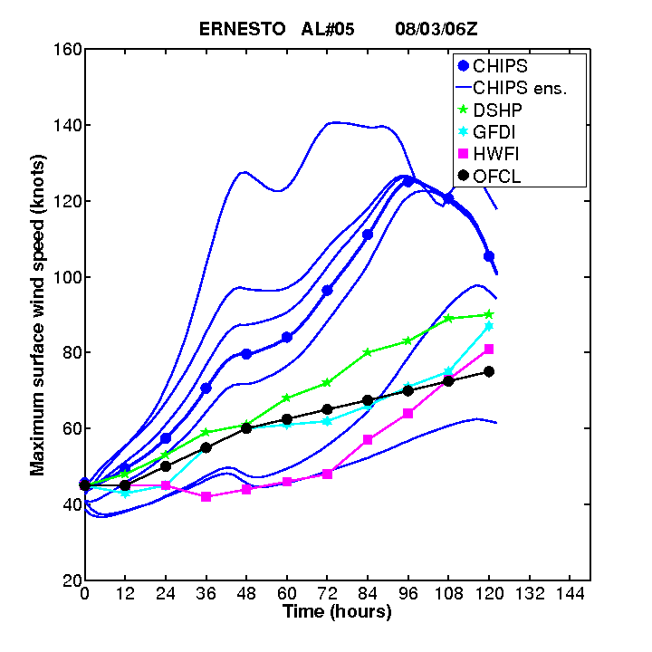
As has been the topic of discussion for the past couple of days here at Thunderbolt Weather, strong wind shear, an inhibitor of tropical development, will limit the potential for rapid strengthening over the next couple of days. It would not surprise me if Ernesto is downgraded at some point. However, the wind shear is expected to weaken and then the opportunity for further strengthening is possible. It would not matter what the system is classified as when it reaches these prime conditions for development, we should have a Hurricane on our hands early next week.
In fact, some of the intensity models are responding to Ernesto moving into much more favorable conditions in a big way. A Major Hurricane is being forecast by several models.


* ATLANTIC SHIPS INTENSITY FORECAST *
* GOES AVAILABLE, OHC AVAILABLE *
* ERNESTO AL052012 08/03/12 00 UTC *
TIME (HR) 0 6 12 18 24 36 48 60 72 84 96 108 120
V (KT) NO LAND 45 48 51 54 57 62 65 69 71 74 78 80 79
V (KT) LAND 45 48 51 54 57 62 65 69 71 74 78 80 79
V (KT) LGE mod 45 49 51 54 56 62 70 77 84 89 93 98 101
Storm Type TROP TROP TROP TROP TROP TROP TROP TROP TROP TROP TROP TROP TROP
SHEAR (KT) 16 15 10 6 5 6 2 11 5 8 4 9 7
SHEAR ADJ (KT) 0 0 0 -3 -5 0 0 -2 -3 -4 -2 0 -2
SHEAR DIR 247 263 276 269 256 317 234 298 260 295 268 291 276
SST (C) 28.1 28.1 28.0 27.9 27.9 28.5 28.2 28.1 28.5 28.4 28.5 28.7 29.0
One thing that caught my eye in the latest forecast discussion from the NHC is:
HOWEVER...GIVEN
THE CURRENT STRUCTURAL CHALLENGES OF THE CYCLONE AND THE POTENTIAL
FOR LAND INTERACTION...THE OFFICIAL FORECAST WILL REMAIN
CONSERVATIVE.
I wounder what conservative is. They current have Ernesto at an 85mph Hurricane at day 5. The NHC must be thinking in the lines of some of the intensity models. Should be interesting.
As for the future track of Ernesto.
The NHC


GFS Ensembles

Early Cycle Track Guidance

I will add in information about 90L and the continued Severe Weather threat shortly in the blog. Additionally, we will take a look at several of the latest model runs and what they mean.

emcf30- Posts : 975
Reputation : 10
Join date : 2012-07-16
Age : 93
Re: Ernesto - 90L - Severe Weather Threat
![]() by emcf30 Fri Aug 03, 2012 8:54 am
by emcf30 Fri Aug 03, 2012 8:54 am
The NHC just colored it yellow. Sorry Trop.

emcf30- Posts : 975
Reputation : 10
Join date : 2012-07-16
Age : 93
Re: Ernesto - 90L - Severe Weather Threat
![]() by scouter534 Fri Aug 03, 2012 8:58 am
by scouter534 Fri Aug 03, 2012 8:58 am

scouter534- Posts : 128
Reputation : 1
Join date : 2012-07-16
Age : 62
Location : Pompano Beach, FL
Re: Ernesto - 90L - Severe Weather Threat
![]() by sangria Fri Aug 03, 2012 9:13 am
by sangria Fri Aug 03, 2012 9:13 am


sangria- Admin
- Posts : 2345
Reputation : 55
Join date : 2012-07-16
Re: Ernesto - 90L - Severe Weather Threat
![]() by emcf30 Fri Aug 03, 2012 9:37 am
by emcf30 Fri Aug 03, 2012 9:37 am
Day two of the Severe Weather threat will include nasty storms that will threaten the High Plains and Upper Midwest today.
The trigger for today's sever thunderstorms is an unusually strong upper-level low pressure diving out of Canada into the High Plains.


Its associated cool pocket of air high up in the atmosphere following hot on the heels of a cold front will clash with a bubble of intense heat and humidity covering most of the Plains. And we know what the outcome will be, Enhanced chance of severe wind gusts, large hailstones and even a few tornadoes will be possible today.
There is also a threat for Severe Weather in portions of Alabama and Mississippi today. The MLCAPE values today in this area are projected to be 2500 to 4000 J/KG. Mid level winds are expected to increase this afternoon which will allow for multicell storms to develop.
The SPC's Convective outlook for today.

AY 1 CONVECTIVE OUTLOOK
NWS STORM PREDICTION CENTER NORMAN OK
0747 AM CDT FRI AUG 03 2012
VALID 031300Z - 041200Z
...THERE IS A SLGT RISK OF SVR TSTMS FROM THE ERN DAKOTAS AND MN
SWWD INTO CENTRAL NEB...
...THERE IS A SLGT RISK OF SVR TSTMS OVER PARTS OF MS AND AL...
...SYNOPSIS...
SATELLITE IMAGERY SHOWS AN UPPER LOW/VORTICITY MAX BECOMING
ELONGATED WITH A NE/SW AXIS AS IT MOVES SEWD ACROSS SRN ALBERTA
TOWARD MT. THIS SYSTEM IS FORECAST TO TURN MORE EWD AS IT MOVES
ACROSS THE NRN MT REGION TODAY...MAINTAINING A POSITIVE TILT AS IT
CONTINUES EWD ALONG THE NRN ND BORDER TONIGHT. A BAND STRONG
WESTERLY FLOW ALOFT ALONG THE SRN PERIPHERY OF THE SYSTEM WILL
SPREAD EWD ACROSS THE NRN PLAINS AND STRENGTHEN THROUGH TONIGHT.
AT THE SURFACE,,,A COLD FRONT WILL MOVE EWD ACROSS THE DAKOTAS TODAY
APPROACHING THE RED RIVER VALLEY BY EVENING...AND PROGRESS TO A ERN
MN/WRN IA/NWRN KS LINE BY LATER TONIGHT. THE FRONT WILL PROVIDE A
PRIMARY FOCUS FOR STRONG/SEVERE THUNDERSTORM DEVELOPMENT. FARTHER
SOUTH IN THE PLAINS AND MS VALLEY...A SECOND FRONT WILL EXTEND FROM
A THERMAL LOW OVER WRN OK/TX PANHANDLE ENEWD ACROSS NRN OK AND
EXTREME SRN MO INTO THE LOWER TN VALLEY. THIS WILL BE REINFORCED
BY OCCASIONAL THUNDERSTORMS OCCURRING ALONG/NORTH OF THE BOUNDARY.
...ERN DAKOTAS/MN SWWD INTO CENTRAL NEB...
SEVERAL ELEVATED CONVECTIVE CLUSTERS ARE CONTINUING OVER PARTS OF
NWRN MN AND SERN SD/NERN NEB IN RESPONSE TO ASCENT ASSOCIATED WITH A
WEAK SHORT WAVE TROUGH AND LOW LEVEL WARM ADVECTION OVER THE AREA.
THE MN STORMS ARE EXPECTED TO PROGRESS EWD WITH DIMINISHING CLOUDS
AND STRONG DIABATIC HEATING EXPECTED OVER ND IN ADVANCE OF THE
AFOREMENTIONED COLD FRONT. FARTHER SOUTH...THE CONVECTION OVER SD
AND NERN NEB IS WEAKENING BUT ASSOCIATED CLOUDS MAY PERSIST THIS
MORNING AND POSSIBLY INHIBIT THE ONSET OF STRONGER DESTABILIZATION
ACROSS PARTS OF THE AREA. THERE WILL BE AN INCREASE IN LOW LEVEL
MOISTURE /SURFACE DEW POINTS REACHING THE MID-UPPER 60S/ AHEAD OF
THE ADVANCING COLD FRONT WHERE SOUTHERLY WINDS WILL STRENGTHEN IN
RESPONSE TO FALLING PRESSURES AHEAD OF THE UPPER TROUGH. THE
COMBINATION OF INCREASING LOW LEVEL MOISTURE...STEEP MID LEVEL LAPSE
RATES AND AREAS OF DIABATIC HEATING WILL RESULT IN AN AXIS OF
MODERATE INSTABILITY WITH MLCAPE OF 1500-2000 J/KG.
THUNDERSTORMS ARE EXPECTED TO INCREASE THIS AFTERNOON NEAR THE COLD
FRONT AS IT PROGRESSES EWD/SEWD ACROSS THE DAKOTAS. WINDS ARE
FORECAST TO VEER AND INCREASE WITH HEIGHT WITH SUFFICIENT VERTICAL
SHEAR /35-45 KT IN THE LOWEST 6 KM/ TO ENHANCE STORM ORGANIZATION
AND INTENSITY...INCLUDING SHORT CONVECTIVE LINES AND OCCASIONAL
SUPERCELLS. THE STEEP LAPSE RATE ENVIRONMENT AND POTENTIAL FOR
ROTATING UPDRAFTS INDICATE A THREAT FOR LARGE HAIL /SOME
SIGNIFICANT/ ALONG WITH DAMAGING WIND GUSTS AND ISOLATED TORNADOES
TO OCCUR WITH STRONGER STORMS AS THEY SPREAD EWD THROUGH THE EVENING
HOURS. STRONG/SEVERE STORMS MAY PERSIST DURING THE NIGHT AS THE
COLD FRONT PROGRESSES EWD AND A STRONG NOCTURNAL SSWLY LOW LEVEL JET
DEVELOPS FROM NRN IA INTO MN.
FARTHER SOUTH INTO NEB...A WARMER DEEPLY MIXED PBL IS FORECAST TO
DEVELOP AHEAD OF THE COLD FRONT AS STRONG DIABATIC HEATING OCCURS
INTO THE AFTERNOON. HIGHER-BASED STORMS ARE LIKELY TO DEVELOP WITH
POTENTIAL TO PRODUCE SEVERE DOWNBURST WINDS AND LARGE
HAIL...ESPECIALLY DURING THE AFTERNOON AND EVENING.
...MS/AL...
SEVERAL CLUSTERS OF STRONGER CONVECTION HAVE DEVELOPED FROM EAST
CENTRAL AR INTO WRN TN WITHIN AN UPPER LEVEL DIFLUENT ZONE ALONG THE
SRN EDGE OF STRONGER WESTERLY HIGH LEVEL WINDS. 12Z SOUNDINGS AT
JAN AND BMX CONTAIN A LAYER OF STEEPER LAPSE RATES BETWEEN 850-500
MB...AND WITH AMPLE LOW LEVEL MOISTURE /LOWEST 100 MB MIXING RATIOS
NEAR 18 G PER KG/...THE AIR MASS IS EXPECTED TO BECOME MODERATELY TO
STRONGLY UNSTABLE THIS AFTERNOON WITH MLCAPE OF 2500-4000 J/KG.
ALTHOUGH WINDS ALOFT ARE CURRENTLY WEAK...STRONGER NNWLY MID LEVEL
WINDS ARE FORECAST TO INCREASE /ESPECIALLY OVER MS/ WITH SOME
POTENTIAL FOR ORGANIZED MULTICELL STORMS TO DEVELOP. THE PRESENCE
OF DRY AIR ABOVE THE PBL AND STEEPENING LOW LEVEL LAPSE RATES WILL
ENHANCE POTENTIAL FOR DAMAGING WET MICROBURSTS TO OCCUR THROUGH THE
AFTERNOON HOURS...ALONG WITH LOCALIZED HAIL.
...CENTRAL PLAINS INTO THE MIDDLE MS VALLEY/LOWER TN VALLEY...
WIDELY SCATTERED THUNDERSTORMS CONTINUE ACROSS PARTS OF CENTRAL/ERN
KS IN ASSOCIATION WITH AN EWD MOVING MCV. ADDITIONAL STORMS HAVEN
BEEN OCCURRING DOWNSTREAM INTO PARTS OF AR AND THE MID SOUTH ALONG
THE ERN EDGE OF A PLUME OF STEEPER MID LEVEL LAPSE RATES EXTENDING
FROM THE PLAINS TO THE MS VALLEY. 20-25 KT MID LEVEL WINDS WILL
PROVIDE SUFFICIENT SHEAR FOR A FEW MULTICELL CLUSTERS TO DEVELOP
WITH POTENTIAL FOR ISOLATED SEVERE STORMS CAPABLE OF PRODUCING
DAMAGING WINDS AND LARGE HAIL THIS AFTERNOON AND EVENING.
..NRN MID-ATLANTIC STATES AND NEW ENGLAND...
RADAR INDICATES SCATTERED WEAK CONVECTION ALONG A COLD FRONT MOVING
SEWD ACROSS NY. ADDITIONAL CONVECTION IS EXPECTED TO DEVELOP INTO
PARTS OF NEW ENGLAND ALONG/SOUTH OF THE BOUNDARY WHERE BREAKS IN
CLOUDS WILL ALLOW STRONGER HEATING AND DESTABILIZATION TO OCCUR. A
FEW STRONG/MARGINALLY SEVERE STORMS MAY BE POSSIBLE BUT OVERALL
THREAT WILL BE LIMITED BY WEAK VERTICAL SHEAR.
..WEISS/SMITH.. 08/03/2012
emcf30- Posts : 975
Reputation : 10
Join date : 2012-07-16
Age : 93
Re: Ernesto - 90L - Severe Weather Threat
![]() by sangria Fri Aug 03, 2012 9:50 am
by sangria Fri Aug 03, 2012 9:50 am
sangria- Admin
- Posts : 2345
Reputation : 55
Join date : 2012-07-16
Re: Ernesto - 90L - Severe Weather Threat
![]() by Seawall Fri Aug 03, 2012 9:53 am
by Seawall Fri Aug 03, 2012 9:53 am
Even if the models are a bit concerning for me at present.. it has to go somewhere. They always do... they always will!

Seawall- Posts : 125
Reputation : 3
Join date : 2012-07-16
Re: Ernesto - 90L - Severe Weather Threat
![]() by emcf30 Fri Aug 03, 2012 10:05 am
by emcf30 Fri Aug 03, 2012 10:05 am
Seawall wrote:Ernesto has turned into a great learning experience for me. There are so many factors influencing the storm, some complicated, some not. Just being able to grasp some of these factors is helping me understand a lot.
Even if the models are a bit concerning for me at present.. it has to go somewhere. They always do... they always will!
And to make more things confusing from what the discussion has been in chat all morning, is that Ernesto is projected by the models and the NHC to defy Climatology. The environment has been lousy in this area but yet, he has seemed to maintain at least some lousy structure and continue to march West of due West. Ernesto will be tip toeing through the Graveyard looking over his shoulder for the grim reaper for the next couple of days. After that, he should be free to develop if he wishes.
emcf30- Posts : 975
Reputation : 10
Join date : 2012-07-16
Age : 93

emcf30- Posts : 975
Reputation : 10
Join date : 2012-07-16
Age : 93
Re: Ernesto - 90L - Severe Weather Threat
![]() by sangria Fri Aug 03, 2012 10:15 am
by sangria Fri Aug 03, 2012 10:15 am
Radar loop of Tropical Storm Ernesto as it passed over St. Lucia at 6 AM EDT today.
http://andrew.rsmas.miami.edu/bmcnoldy/tropics/ernesto12/Ernesto_03-04Aug12_Martinique.gif

sangria- Admin
- Posts : 2345
Reputation : 55
Join date : 2012-07-16
Re: Ernesto - 90L - Severe Weather Threat
![]() by StAugustineFL Fri Aug 03, 2012 10:17 am
by StAugustineFL Fri Aug 03, 2012 10:17 am

StAugustineFL- Posts : 2231
Reputation : 64
Join date : 2012-07-17
Re: Ernesto - 90L - Severe Weather Threat
![]() by emcf30 Fri Aug 03, 2012 10:24 am
by emcf30 Fri Aug 03, 2012 10:24 am
The Tropical Disturbance South of the Cape Verde Islands has been classified by the NHC as 90L. This wave looked impressive as it moved off the coast of Africa.

The environmental conditions surrounding 90L are somewhat favorable for development over the next few days. It would not surprise me to see this upgraded to Tropical Storm Florence sometime this weekend or early next week.
Here is some early track guidance and intensity forecast.


* ATLANTIC SHIPS INTENSITY FORECAST *
* GOES PROXY USED, OHC AVAILABLE *
* INVEST AL902012 08/03/12 12 UTC *
TIME (HR) 0 6 12 18 24 36 48 60 72 84 96 108 120
V (KT) NO LAND 30 31 33 35 38 44 47 50 52 53 54 55 55
V (KT) LAND 30 31 33 35 38 44 47 50 52 53 54 55 55
V (KT) LGE mod 30 31 32 33 35 39 45 51 56 61 63 63 61
Storm Type TROP TROP TROP TROP TROP TROP TROP TROP TROP TROP TROP TROP TROP
SHEAR (KT) 23 18 13 10 7 12 8 10 11 13 10 17 16
SHEAR ADJ (KT) -2 1 5 5 8 3 7 4 4 1 7 4 5
SHEAR DIR 36 41 59 81 79 124 136 157 172 206 244 240 289
SST (C) 26.9 26.8 26.7 26.8 26.9 26.8 26.6 26.5 26.4 26.3 26.5 26.7 27.4
This one may go swimming with the fishes.
emcf30- Posts : 975
Reputation : 10
Join date : 2012-07-16
Age : 93
Re: Ernesto - 90L - Severe Weather Threat
![]() by emcf30 Fri Aug 03, 2012 10:53 am
by emcf30 Fri Aug 03, 2012 10:53 am

Rain chances going up in Florida beginning this afternoon and into the weekend.

Coastal storms will develop early this afternoon, then transition mainly inland later today.
An upper level disturbance will result in greater instability over the region today due to colder temperatures in the mid to upper atmosphere. This feature, combined with increased moisture and a more southerly steering flow should result in a higher coverage and intensity of storms this afternoon compared to the last few days. Initial storm formation will be most likely just inland from the coast early this afternoon, primarily from northern Brevard County to Martin County. Storm motion will be toward the north or northwest at 10 to 15 mph. Later this afternoon, showers and storms will gradually transition inland, with the trend favoring an increased coverage and intensity of storms.
Over the coastal waters, isolated showers and storms, mainly beyond 20 miles of the coast will move slowly north. A few showers and storms along the southeast Florida coast, extending north to Jupiter Inlet and Hobe Sound will lift slowly north and will produce periods of heavy rain and occasional lightning this morning.
Excerpt from the NWS Melbourne Forecast Discussion
THIS WEEKEND...WEAK T-WAVE WILL ROUND THE WESTERN PERIPHERY OF THE
ATLC HIGH PRES RIDGE...RIDING NORTHWARD INTO THE WEAKNESS OVER FL.
THIS WILL BRING WITH IT AN INCREASE IN MEAN PWAT AND POPS IN A MORE
CONVERGENT SE WIND FLOW. PAINTED SLIGHTLY HIGHER POPS (60-65 PERCENT
AREAWIDE) SATURDAY AS MOISTURE SHOULD BE HIGHER AND THE FLOW NOT
QUITE AS BACKED AS IT WILL BE SUN...WHEN POPS WILL BE 50 COAST AND
60 INLAND. MAX TEMPS FAIRLY CLOSE TO CLIMO NORMS...WITH SULTRY MINS
A FEW DEGREES ABOVE NORMAL OUTSIDE OF AREAS THAT RECEIVE DECENT
AMOUNT OF PRECIP.
Last edited by emcf30 on Fri Aug 03, 2012 10:55 am; edited 1 time in total
emcf30- Posts : 975
Reputation : 10
Join date : 2012-07-16
Age : 93
Re: Ernesto - 90L - Severe Weather Threat
![]() by sangria Fri Aug 03, 2012 10:53 am
by sangria Fri Aug 03, 2012 10:53 am
sangria- Admin
- Posts : 2345
Reputation : 55
Join date : 2012-07-16
Re: Ernesto - 90L - Severe Weather Threat
![]() by sangria Fri Aug 03, 2012 10:59 am
by sangria Fri Aug 03, 2012 10:59 am
The flight of the Hurricane Hunter.
— NWS Tampa Bay (@NWSTampaBay) August 3, 2012#flwx twitter.com/NWSTampaBay/st…
sangria- Admin
- Posts : 2345
Reputation : 55
Join date : 2012-07-16
Re: Ernesto - 90L - Severe Weather Threat
![]() by emcf30 Fri Aug 03, 2012 11:01 am
by emcf30 Fri Aug 03, 2012 11:01 am
sangria wrote:Looks like the first half of August will be busy.........speaking of which....has El Nino stalled?
EL NIÑO/SOUTHERN OSCILLATION (ENSO)
DIAGNOSTIC DISCUSSION
issued by
CLIMATE PREDICTION CENTER/NCEP
and the International Research Institute for Climate and Society
5 July 2012
During June 2012, ENSO-neutral continued as reflected in both the oceanic and atmospheric anomalies. However, positive equatorial Pacific sea surface temperature (SST) anomalies have grown, exceeding +0.5oC across the eastern Pacific Ocean by the end of June (Fig. 1). SST anomalies increase moving from the westernmost Niño 4 region to the Niño 1+2 region adjacent to South America, which remained near +1.5oC during the month (Fig. 2). The oceanic heat content anomalies (average temperature in the upper 300m of the ocean) increased during June (Fig. 3), as above-average sub-surface temperatures became more entrenched in the equatorial Pacific (Fig. 4). This warming was consistent with a weakening of the low-level trade winds across the east-central equatorial Pacific, along with a weakening of the persistent pattern of enhanced convection near Papua New Guinea (Fig. 5). The observations are consistent with ENSO-neutral, but reflect a likely progression towards El Niño.
There continues to be a substantial disparity between the statistical and dynamical model SST forecasts for the Niño-3.4 region (Fig. 6). The dynamical models, including the NCEP Climate Forecast System (CFS), largely favor the development of El Niño by July-September 2012, while the majority of statistical models predict ENSO-neutral through the rest of 2012. The forecaster consensus largely favors the dynamical model outcome because those models tend to exhibit greater skill emerging from the Northern Hemisphere "spring barrier" (a period of relatively low confidence ENSO forecasts) and also due to the strengthening of observed signals indicating an evolution towards El Niño. Overall, the forecaster consensus reflects increased chances for El Niño beginning in July-September 2012 (see CPC/IRI consensus forecast).
emcf30- Posts : 975
Reputation : 10
Join date : 2012-07-16
Age : 93
Re: Ernesto - 90L - Severe Weather Threat
![]() by sangria Fri Aug 03, 2012 11:05 am
by sangria Fri Aug 03, 2012 11:05 am
sangria- Admin
- Posts : 2345
Reputation : 55
Join date : 2012-07-16
Re: Ernesto - 90L - Severe Weather Threat
![]() by sangria Fri Aug 03, 2012 11:17 am
by sangria Fri Aug 03, 2012 11:17 am
http://www.atmos.washington.edu/~ovens/wxloop.cgi?fronts_ir_east+/48h/

sangria- Admin
- Posts : 2345
Reputation : 55
Join date : 2012-07-16
Re: Ernesto - 90L - Severe Weather Threat
![]() by sangria Fri Aug 03, 2012 11:29 am
by sangria Fri Aug 03, 2012 11:29 am
000
WTNT35 KNHC 031453
TCPAT5
BULLETIN
TROPICAL STORM ERNESTO ADVISORY NUMBER 8
NWS NATIONAL HURRICANE CENTER MIAMI FL AL052012
1100 AM AST FRI AUG 03 2012
...ERNESTO MOVING AWAY FROM THE WINDWARD ISLANDS...TROPICAL STORM
WARNINGS HAVE BEEN DISCONTINUED...
SUMMARY OF 1100 AM AST...1500 UTC...INFORMATION
-----------------------------------------------
LOCATION...13.7N 62.3W
ABOUT 90 MI...140 KM W OF ST. LUCIA
ABOUT 410 MI...660 KM SE OF SAN JUAN PUERTO RICO
MAXIMUM SUSTAINED WINDS...50 MPH...85 KM/H
PRESENT MOVEMENT...W OR 275 DEGREES AT 21 MPH...33 KM/H
MINIMUM CENTRAL PRESSURE...1002 MB...29.59 INCHES
WATCHES AND WARNINGS
--------------------
CHANGES WITH THIS ADVISORY...
ALL TROPICAL STORM WARNINGS HAVE BEEN DISCONTINUED BY THE
APPROPRIATE GOVERNMENTS.
SUMMARY OF WATCHES AND WARNINGS IN EFFECT...
NONE.
FOR STORM INFORMATION SPECIFIC TO YOUR AREA...PLEASE MONITOR
PRODUCTS ISSUED BY YOUR NATIONAL METEOROLOGICAL SERVICE.
DISCUSSION AND 48-HOUR OUTLOOK
------------------------------
AT 1100 AM AST...1500 UTC...THE CENTER OF TROPICAL STORM ERNESTO WAS
LOCATED NEAR LATITUDE 13.7 NORTH...LONGITUDE 62.3 WEST. ERNESTO IS
MOVING TOWARD THE WEST NEAR 21 MPH...33 KM/H...AND THIS GENERAL
MOTION IS EXPECTED TO CONTINUE DURING THE NEXT COUPLE OF DAYS. ON
THE FORECAST TRACK ERNESTO WILL BE MOVING ACROSS THE EASTERN AND
CENTRAL CARIBBEAN SEA DURING THE NEXT 48 HOURS.
MAXIMUM SUSTAINED WINDS ARE NEAR 50 MPH...85 KM/H...WITH HIGHER
GUSTS. LITTLE CHANGE IN INTENSITY IS EXPECTED TODAY BUT SOME
STRENGTHENING IS FORECAST THEREAFTER.
TROPICAL STORM FORCE WINDS EXTEND OUTWARD UP TO 85 MILES...140 KM
FROM THE CENTER.
ESTIMATED MINIMUM CENTRAL PRESSURE IS 1002 MB...29.59 INCHES.
HAZARDS AFFECTING LAND
----------------------
WIND...WINDS ARE EXPECTED TO DIMINISH IN PORTIONS OF THE WINDWARD
ISLANDS TODAY.
RAINFALL...TOTAL RAINFALL ACCUMULATIONS OF 2 TO 3 INCHES WITH
ISOLATED MAXIMUM AMOUNTS OF 5 INCHES ARE STILL POSSIBLE ACROSS THE
WINDWARD ISLANDS THROUGH TODAY.
SURF...LARGE WAVES GENERATED BY ERNESTO IN THE VICINITY OF THE
WINDWARD ISLANDS WILL GRADUALLY SUBSIDE. PLEASE CONSULT PRODUCTS
FROM YOUR LOCAL WEATHER OFFICE.
NEXT ADVISORY
-------------
NEXT COMPLETE ADVISORY...500 PM AST.
$$
FORECASTER AVILA
sangria- Admin
- Posts : 2345
Reputation : 55
Join date : 2012-07-16
Re: Ernesto - 90L - Severe Weather Threat
![]() by sangria Fri Aug 03, 2012 11:42 am
by sangria Fri Aug 03, 2012 11:42 am
000
WTNT45 KNHC 031454
TCDAT5
TROPICAL STORM ERNESTO DISCUSSION NUMBER 8
NWS NATIONAL HURRICANE CENTER MIAMI FL AL052012
1100 AM AST FRI AUG 03 2012
DATA FROM A RECONNAISSANCE PLANE AND RADAR FROM MARTINIQUE SHOWED
THE SMALL BUT WELL-DEFINED CENTER OF ERNESTO MOVED WESTWARD JUST
SOUTH OF OR OVER ST. LUCIA EARLY THIS MORNING. BASED ON THE
AIRCRAFT AND SURFACE OBSERVATIONS...THE INITIAL INTENSITY IS SET AT
45 KNOTS. THESE WINDS ARE CONFINED TO A SMALL AREA NORTH OF THE
CENTER. FAST-MOVING TROPICAL CYCLONES TYPICALLY DO NOT STRENGTHEN
MUCH AND IN FACT...LATEST SATELLITE IMAGES INDICATE LITTLE CHANGE
IN THE STRUCTURE OF THE CYCLONE.
ERNESTO IS MOVING TOWARD THE WEST OR 275 DEGREES AT 18 KNOTS
EMBEDDED WITHIN A FAST EASTERLY FLOW SOUTH OF THE SUBTROPICAL
RIDGE. THIS STEERING PATTERN SHOULD KEEP THE CYCLONE ON A GENERAL
WESTWARD TRACK FOR THE NEXT 2 TO 3 DAYS. BY THE TIME ERNESTO
REACHES THE WESTERN CARIBBEAN...THE STEERING FLOW IS EXPECTED TO
WEAKEN AND ERNESTO IS FORECAST TO SLOW DOWN. THE COMBINATION OF LOW
SHEAR AND HIGH UPPER-OCEAN HEAT CONTENT IN THE WESTERN CARIBBEAN
SEA WOULD FAVOR SOME INTENSIFICATION...AND ERNESTO IS FORECAST TO
BECOME A HURRICANE IN THE NORTHWESTERN CARIBBEAN SEA. THE OFFICIAL
FORECAST FOLLOWS THE INTENSITY CONSENSUS...BUT ONE SHOULD NOTE THAT
BOTH THE SHIPS AND LGEM INTENSITY MODELS ARE FORECASTING A STRONGER
HURRICANE.
MOST OF THE TRACK GUIDANCE IS IN PRETTY GOOD AGREEMENT THAT ERNESTO
WILL BE RACING WESTWARD ACROSS THE EASTERN AND CENTRAL CARIBBEAN
DURING THE NEXT 2 TO 3 DAYS. AFTER THAT...TRACK MODELS DIVERGE
CONSIDERABLY AND SOME MODELS KEEP ERNESTO ON A MORE WESTWARD
TRACK...WHILE ANOTHER GROUP TURN THE CYCLONE MORE TO THE
NORTHWEST...DEPENDING UPON HOW THE MODELS DEPICT THE STRENGTH OF
RIDGE TO THE NORTH. NEVERTHELESS...ALL INDICATIONS ARE THAT ERNESTO
WILL BE MOVING ACROSS THE NORTHWESTERN CARIBBEAN SEA IN 4 TO 5
DAYS.
FORECAST POSITIONS AND MAX WINDS
INIT 03/1500Z 13.7N 62.3W 45 KT 50 MPH
12H 04/0000Z 13.9N 64.9W 45 KT 50 MPH
24H 04/1200Z 14.4N 68.1W 50 KT 60 MPH
36H 05/0000Z 15.0N 71.2W 55 KT 65 MPH
48H 05/1200Z 15.5N 74.5W 60 KT 70 MPH
72H 06/1200Z 17.0N 80.0W 65 KT 75 MPH
96H 07/1200Z 18.5N 83.5W 75 KT 85 MPH
120H 08/1200Z 20.5N 87.0W 80 KT 90 MPH
$$
FORECASTER AVILA
[i]
sangria- Admin
- Posts : 2345
Reputation : 55
Join date : 2012-07-16
Re: Ernesto - 90L - Severe Weather Threat
![]() by sangria Fri Aug 03, 2012 11:50 am
by sangria Fri Aug 03, 2012 11:50 am

sangria- Admin
- Posts : 2345
Reputation : 55
Join date : 2012-07-16
Re: Ernesto - 90L - Severe Weather Threat
![]() by emcf30 Fri Aug 03, 2012 11:52 am
by emcf30 Fri Aug 03, 2012 11:52 am
sangria wrote:At 370 meters per pixel, the infrared imagery of the Suomi NPP satellite provides amazing detail of the cloud structures of Tropical Storm Ernesto. The satellite passed over Ernesto on August 3, 2012 at 05:12z as the storm approached the Lesser Antilles. The center of Ernesto has since passed between the Grenadines and Saint Lucia, and is heading west into the Caribbean with 50 mph winds. The National Hurricane Center expects the storm to strengthen to hurricane strength over the next 48-72 hours.
Me likes that image. Thanks San

emcf30- Posts : 975
Reputation : 10
Join date : 2012-07-16
Age : 93

emcf30- Posts : 975
Reputation : 10
Join date : 2012-07-16
Age : 93

emcf30- Posts : 975
Reputation : 10
Join date : 2012-07-16
Age : 93

sangria- Admin
- Posts : 2345
Reputation : 55
Join date : 2012-07-16
Re: Ernesto - 90L - Severe Weather Threat
![]() by sangria Fri Aug 03, 2012 12:02 pm
by sangria Fri Aug 03, 2012 12:02 pm
sangria- Admin
- Posts : 2345
Reputation : 55
Join date : 2012-07-16

emcf30- Posts : 975
Reputation : 10
Join date : 2012-07-16
Age : 93
Re: Ernesto - 90L - Severe Weather Threat
![]() by emcf30 Fri Aug 03, 2012 12:03 pm
by emcf30 Fri Aug 03, 2012 12:03 pm
sangria wrote:Like that loop from the Navy site......
Yep, I am playing around with the image hosting features of a few sites
emcf30- Posts : 975
Reputation : 10
Join date : 2012-07-16
Age : 93

emcf30- Posts : 975
Reputation : 10
Join date : 2012-07-16
Age : 93
Re: Ernesto - 90L - Severe Weather Threat
![]() by emcf30 Fri Aug 03, 2012 12:23 pm
by emcf30 Fri Aug 03, 2012 12:23 pm

4. SUSPECT AREA (OFF EAST COAST OF FLORIDA)
FLIGHT ONE -TEAL 73-
A. 04/1900Z
B. AFXXX 01BBA INVEST
C. 04/1700Z
D. 28.0N 80.0W
E. 04/1830Z TO 04/2130Z
F. SFC TO 10,000 FT h
Last edited by emcf30 on Fri Aug 03, 2012 12:33 pm; edited 2 times in total
emcf30- Posts : 975
Reputation : 10
Join date : 2012-07-16
Age : 93
Re: Ernesto - 90L - Severe Weather Threat
![]() by sangria Fri Aug 03, 2012 12:26 pm
by sangria Fri Aug 03, 2012 12:26 pm
sangria- Admin
- Posts : 2345
Reputation : 55
Join date : 2012-07-16
Re: Ernesto - 90L - Severe Weather Threat
![]() by sangria Fri Aug 03, 2012 12:37 pm
by sangria Fri Aug 03, 2012 12:37 pm

Last edited by sangria on Fri Aug 03, 2012 12:40 pm; edited 2 times in total
sangria- Admin
- Posts : 2345
Reputation : 55
Join date : 2012-07-16
Re: Ernesto - 90L - Severe Weather Threat
![]() by emcf30 Fri Aug 03, 2012 12:38 pm
by emcf30 Fri Aug 03, 2012 12:38 pm

emcf30- Posts : 975
Reputation : 10
Join date : 2012-07-16
Age : 93
Re: Ernesto - 90L - Severe Weather Threat
![]() by emcf30 Fri Aug 03, 2012 12:39 pm
by emcf30 Fri Aug 03, 2012 12:39 pm
sangria wrote:Look at Africa pumping them out!!!


Last edited by emcf30 on Fri Aug 03, 2012 12:47 pm; edited 2 times in total
emcf30- Posts : 975
Reputation : 10
Join date : 2012-07-16
Age : 93
Re: Ernesto - 90L - Severe Weather Threat
![]() by sangria Fri Aug 03, 2012 12:42 pm
by sangria Fri Aug 03, 2012 12:42 pm
sangria- Admin
- Posts : 2345
Reputation : 55
Join date : 2012-07-16
Re: Ernesto - 90L - Severe Weather Threat
![]() by gomexwx Fri Aug 03, 2012 12:47 pm
by gomexwx Fri Aug 03, 2012 12:47 pm

gomexwx- Posts : 641
Reputation : 63
Join date : 2012-07-16
Location : On an Acre somewhere on the gulf Coast
Re: Ernesto - 90L - Severe Weather Threat
![]() by emcf30 Fri Aug 03, 2012 1:15 pm
by emcf30 Fri Aug 03, 2012 1:15 pm
gomexwx wrote:I do not like the GFDL...too close to home
I can see why, heading right for ya.

emcf30- Posts : 975
Reputation : 10
Join date : 2012-07-16
Age : 93
Re: Ernesto - 90L - Severe Weather Threat
![]() by emcf30 Fri Aug 03, 2012 1:33 pm
by emcf30 Fri Aug 03, 2012 1:33 pm

emcf30- Posts : 975
Reputation : 10
Join date : 2012-07-16
Age : 93
Re: Ernesto - 90L - Severe Weather Threat
![]() by emcf30 Fri Aug 03, 2012 1:40 pm
by emcf30 Fri Aug 03, 2012 1:40 pm


Last edited by emcf30 on Fri Aug 03, 2012 1:43 pm; edited 1 time in total
emcf30- Posts : 975
Reputation : 10
Join date : 2012-07-16
Age : 93
Re: Ernesto - 90L - Severe Weather Threat
![]() by sangria Fri Aug 03, 2012 1:41 pm
by sangria Fri Aug 03, 2012 1:41 pm
sangria- Admin
- Posts : 2345
Reputation : 55
Join date : 2012-07-16

StAugustineFL- Posts : 2231
Reputation : 64
Join date : 2012-07-17

sangria- Admin
- Posts : 2345
Reputation : 55
Join date : 2012-07-16

sangria- Admin
- Posts : 2345
Reputation : 55
Join date : 2012-07-16
emcf30- Posts : 975
Reputation : 10
Join date : 2012-07-16
Age : 93

sangria- Admin
- Posts : 2345
Reputation : 55
Join date : 2012-07-16
Page 1 of 2 • 1, 2 ![]()
» SEVERE WEATHER THREAT FOR TEXAS,THEN SHIFTING EASTWARD
» Tropical Storm Ernesto - Severe Weather
» Ernesto, Florence, And Severe Weather At Home
» New Year Look Ahead. Whats next.


» summer 2019 hurricane season
» April-May Florida weather and local events etc
» NASCAR 2019
» Late January through February outlook
» FLORIDA/ALABAMA AND THE HOLIDAY SEASON WEATHER
» NASCAR 2018
» CLOSED Florida/Alabama Blog - October Tropical Mischief