


Late January through February outlook
:: Florida Blog
Page 2 of 16 •  1, 2, 3 ... 9 ... 16
 ![]()
Re: Late January through February outlook
![]() by LargoFL Thu Jan 17, 2019 4:14 pm
by LargoFL Thu Jan 17, 2019 4:14 pm


LargoFL- Posts : 10724
Reputation : 130
Join date : 2017-03-05
Re: Late January through February outlook
![]() by LargoFL Thu Jan 17, 2019 4:16 pm
by LargoFL Thu Jan 17, 2019 4:16 pm
LargoFL- Posts : 10724
Reputation : 130
Join date : 2017-03-05
Re: Late January through February outlook
![]() by LargoFL Thu Jan 17, 2019 4:18 pm
by LargoFL Thu Jan 17, 2019 4:18 pm

LargoFL- Posts : 10724
Reputation : 130
Join date : 2017-03-05
Re: Late January through February outlook
![]() by StAugustineFL Thu Jan 17, 2019 4:56 pm
by StAugustineFL Thu Jan 17, 2019 4:56 pm
Happy to see a couple shots of rain although it seems the cold is backing off quite a bit. I thought the big shot of cold was coming Sunday night/Monday but it'll actually be equal to or warmer than the past few days (at least in this part of the state)
Headed to Inverness for a day trip on Saturday for a funeral. My "work wife" had a double whammy. Her mom passed on Christmas Eve which is also her birthday. I'm sure her birthday and Christmas will suck for a few years.

StAugustineFL- Posts : 2231
Reputation : 64
Join date : 2012-07-17
Re: Late January through February outlook
![]() by BillsfaninSoFla Thu Jan 17, 2019 5:07 pm
by BillsfaninSoFla Thu Jan 17, 2019 5:07 pm
Thank Largo, I’m feeling much better. That was a nasty bug.
When you guys are going to be chilly!
BillsfaninSoFla- Posts : 1966
Reputation : 52
Join date : 2017-03-05
Re: Late January through February outlook
![]() by LargoFL Fri Jan 18, 2019 4:38 am
by LargoFL Fri Jan 18, 2019 4:38 am
...MODERATE RISK OF RIP CURRENTS ATLANTIC BEACHES...
...CHILLY TEMPERATURES THIS MORNING FOR INTERIOR...
This hazardous weather outlook is for South Florida.
.DAY ONE...TODAY AND TONIGHT
Rip currents: There is a moderate risk of rip currents along all
Atlantic beaches.
Temperatures: Temperatures across the interior will once again drop
below 50 degrees this morning. The lowest temperatures will be in the
upper 40s across Glades and Hendry counties to around 50 across
interior Collier and far inland Palm Beach and Broward counties.
.DAYS TWO THROUGH SEVEN...SATURDAY THROUGH THURSDAY
The rip current risk will remain elevated along the east coast
beaches through at least Saturday. The rip current risk is expected
to increase along the Collier County beaches on Sunday.
A cold front is forecast to sweep across South Florida on Sunday.
Gusty winds and building seas will likely lead to hazardous marine
conditions over all local waters Sunday and Monday.
There could also be some minor coastal flooding along with rough surf
conditions along the beaches of Collier County on Sunday with the
passage of the cold front.
Temperatures behind the cold front will fall into the 40s and lower
50s across most of South Florida late Sunday night into early Monday
morning, with upper 30s possible across the Lake Okeechobee region.
Wind chill values may drop into the 30s and and low 40s over much of
South Florida during this time frame.
.SPOTTER INFORMATION STATEMENT...
Spotter activation will not be needed.
For more information...visit the National Weather Service in
Miami website at www.weather.gov/miami.
$$
LargoFL- Posts : 10724
Reputation : 130
Join date : 2017-03-05
Re: Late January through February outlook
![]() by LargoFL Fri Jan 18, 2019 4:41 am
by LargoFL Fri Jan 18, 2019 4:41 am
National Weather Service Tampa Bay Ruskin FL
322 AM EST Fri Jan 18 2019
.SHORT TERM (Today - Saturday)...
Weak surface high pressure will continue to ridge from the
western Atlantic across the Florida Peninsula today, setting
up quiet weather conditions. After a cool start to the
morning, mostly sunny skies and light winds will allow
temperatures to quickly warm up to near to slightly above
normal, generally in the 70s.
These quiet and seasonable conditions will continue tonight
into Saturday morning, but then the pattern will start to
shift by Saturday afternoon as a strong upper level trough
digs into the southeastern US. At the surface, this trough
will fuel an area of low pressure lifting from the
southeastern states into the Mid-Atlantic, dragging a cold
front through the Gulf of Mexico and into Florida. Southerly
low level winds ahead of this front will support increasing
temperatures and humidity Saturday afternoon, with high
temperatures expected to approach 80 over the interior. The
building moisture ahead of the front will also fuel an area
of showers and thunderstorms that will move into the
coastal waters Saturday afternoon, with a slight chance of
showers moving onshore late in the day.
.LONG TERM (Saturday Night - Thursday)...
Numerous showers with scattered thunderstorms will move
southeast through the forecast area Saturday evening along
and ahead of a cold front, with rain chances tapering off
on Sunday as the front pushes south of Florida. Breezy
northwest winds behind the front on Sunday will produce
numerous rip currents along area beaches and cause strong
cold air advection, with afternoon highs forecast to top out
from the upper 50s to around 70. Lows Monday morning will
drop into the 30s over the interior and along the Nature
Coast, and into the low to mid 40s farther south. Cold air
advection will gradually subside Monday as high pressure
builds in north of Florida, shifting winds to easterly.
Temperatures will moderate Tuesday and Wednesday, then
another cold front is forecast to approach the area late in
the week. There are some timing differences with the global
models of when this front will move through the area, but
they do agree that the front will bring another round of
showers and thunderstorms, with a strong shot of cold air
filling in behind the front. The long term forecast will
have to be closely monitored until the global model guidance
falls into better agreement.
&&
LargoFL- Posts : 10724
Reputation : 130
Join date : 2017-03-05
Re: Late January through February outlook
![]() by LargoFL Fri Jan 18, 2019 4:45 am
by LargoFL Fri Jan 18, 2019 4:45 am
LargoFL- Posts : 10724
Reputation : 130
Join date : 2017-03-05

LargoFL- Posts : 10724
Reputation : 130
Join date : 2017-03-05
Re: Late January through February outlook
![]() by LargoFL Fri Jan 18, 2019 7:43 am
by LargoFL Fri Jan 18, 2019 7:43 am

LargoFL- Posts : 10724
Reputation : 130
Join date : 2017-03-05
LargoFL- Posts : 10724
Reputation : 130
Join date : 2017-03-05
Re: Late January through February outlook
![]() by LargoFL Fri Jan 18, 2019 12:36 pm
by LargoFL Fri Jan 18, 2019 12:36 pm
.DAY ONE...TODAY AND TONIGHT.
.RIP CURRENT IMPACT...
A dampening long period swell will still be sufficient to produce
a moderate risk of rip currents at area beaches. This is
especially true during the time of outgoing tide this morning.
Always swim within sight of a lifeguard.
.DAYS TWO THROUGH SEVEN...SATURDAY THROUGH THURSDAY.
A strong cold front is forecast to bring a good chance for some
rain and possibly a few thunderstorms Saturday night. Rainfall
amounts should be less than a half inch north of Orlando and less
than a quarter inch south of Orlando.
Boating conditions will deteriorate ahead of the front Saturday
night as southwest winds increase. Then strong west to northwest
winds will develop behind the front Sunday into Monday and bring
hazardous winds and seas over the local Atlantic waters. Much
colder air will overspread the area Sunday night with temperatures
dipping to the mid and upper 30s many areas Monday morning, along
with wind chills dipping into the lower 30s in exposed locations.
.SPOTTER INFORMATION STATEMENT...
Spotter activation will not be needed today.
$$
Kelly/Sedlock
LargoFL- Posts : 10724
Reputation : 130
Join date : 2017-03-05
LargoFL- Posts : 10724
Reputation : 130
Join date : 2017-03-05
Re: Late January through February outlook
![]() by LargoFL Fri Jan 18, 2019 1:59 pm
by LargoFL Fri Jan 18, 2019 1:59 pm
LargoFL- Posts : 10724
Reputation : 130
Join date : 2017-03-05

LargoFL- Posts : 10724
Reputation : 130
Join date : 2017-03-05
Re: Late January through February outlook
![]() by LargoFL Sat Jan 19, 2019 5:12 am
by LargoFL Sat Jan 19, 2019 5:12 am
National Weather Service Tampa Bay Ruskin FL
243 AM EST Sat Jan 19 2019
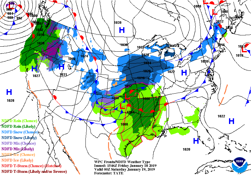
...STRONG TO SEVERE STORMS POSSIBLE TONIGHT...
.SHORT TERM (Today - Sunday)...
Complex storm system to move through the region producing
numerous impacts and hazards for the local area through the
weekend.
Upper low/trough over the S plains this morning to deepen
today as it moves through the MS River Valley with axis
digging down into the Gulf. Associated surface system
developing this morning with warm front over the Deep South
and W Atlantic high pressure ridging over the FL Peninsula.
Pressure gradient between features to tighten today with
southerly surface flow increasing dew points and temps to
above normal averages.
Active weather expected tonight as significant upper energy
pushes pre frontal squall line of showers and embedded
thunderstorms through the E Gulf and FL Peninsula overnight.
SPC has outlooked the area in marginal risk of severe storms
with damaging wind gusts and isolated tornadoes expected as
the main threats with the line of convection. Near 100 PoPs
most areas with rainfall totals of half to 1+ inch expected
as line moves through the Peninsula. Will continue to monitor
the situation closely and update forecasts and briefings as
needed.
Ahead of the storms, the strong southerly winds over the E
Gulf will increase tonights near full moon normal high
tides with 2-3 ft above normal water levels in Levy and
Citrus Cos, with 1-2 ft above normal water from the Tampa
Bay to SW FL areas.
After the cold front, strong and cold Canadian high pressure
will build into the region for clearing and breezy conditions
and well below normal temps Sunday. The breezy NW winds will
create hazardous beach conditions as large breaking waves lead
to high surf and dangerous rip currents.
LargoFL- Posts : 10724
Reputation : 130
Join date : 2017-03-05
Re: Late January through February outlook
![]() by LargoFL Sat Jan 19, 2019 5:18 am
by LargoFL Sat Jan 19, 2019 5:18 am
LargoFL- Posts : 10724
Reputation : 130
Join date : 2017-03-05
Re: Late January through February outlook
![]() by StAugustineFL Sat Jan 19, 2019 7:32 am
by StAugustineFL Sat Jan 19, 2019 7:32 am
StAugustineFL- Posts : 2231
Reputation : 64
Join date : 2012-07-17
Re: Late January through February outlook
![]() by StAugustineFL Sat Jan 19, 2019 7:35 am
by StAugustineFL Sat Jan 19, 2019 7:35 am

StAugustineFL- Posts : 2231
Reputation : 64
Join date : 2012-07-17

StAugustineFL- Posts : 2231
Reputation : 64
Join date : 2012-07-17
Re: Late January through February outlook
![]() by LargoFL Sat Jan 19, 2019 7:51 am
by LargoFL Sat Jan 19, 2019 7:51 am
ok have a safe trip home Aug..you might be right, the severe storm info seems to be on the gulf coast side..i know im in for it tonight for sure whew..alrady did the gutters and im taking in things that can blow around etc..say..i caught the end of a future weather report on tv for this week and..the met was saying a SOLID FREEZE was coming this week...could this be the next cold front wens-thurs???...man i would have alot of covering plants-bushes etc to do.StAugustineFL wrote:Morning. Be safe tonight west coasters. I'll be in Inverness from roughly 12-3 but should be on the return trip back to St Aug prior to the arrival of any storms. Arrival time of rain actually appears to be after midnight. Looks like the storms weaken as they head towards the east side of the state. Only rain forecast here on the whole with potentially a thunderstorm.
LargoFL- Posts : 10724
Reputation : 130
Join date : 2017-03-05
Re: Late January through February outlook
![]() by LargoFL Sat Jan 19, 2019 8:08 am
by LargoFL Sat Jan 19, 2019 8:08 am
LargoFL- Posts : 10724
Reputation : 130
Join date : 2017-03-05
Re: Late January through February outlook
![]() by LargoFL Sat Jan 19, 2019 8:10 am
by LargoFL Sat Jan 19, 2019 8:10 am
LargoFL- Posts : 10724
Reputation : 130
Join date : 2017-03-05
Re: Late January through February outlook
![]() by LargoFL Sat Jan 19, 2019 9:21 am
by LargoFL Sat Jan 19, 2019 9:21 am
National Weather Service Tampa Bay Ruskin FL
840 AM EST Sat Jan 19 2019
...STRONG TO SEVERE STORMS POSSIBLE TONIGHT...
...TURNING SHARPLY COLDER SUNDAY INTO MONDAY...
.UPDATE...
High pressure from the western Atlantic extending west
across the south-central peninsula early this morning
will move east the remainder of today as a strong cold
front approaches from the west. An increasing low level
southerly wind flow ahead of the front will support a
warm day with temperatures climbing to above normal with
readings in the upper 70s to around 80 expected during
the afternoon along with a mix of clouds and sun. Current
forecast has a good handle on this, so a morning update is
not required at this time.
Tonight some active weather is expected across the forecast
area as a strong cold front move into and through the area
overnight with a pre-frontal squall line of showers and
embedded thunderstorms moving in from the Gulf overnight
along and ahead of the front. The Storm Prediction Center
has placed a large portion of the forecast area in a
Marginal Risk for severe storms with damaging winds and
isolated tornadoes the main hazards. In addition to the
severe threat some locally heavy rains and occasional
lightning strikes will accompany the storms. In the wake of
the front on Sunday strong cold Canadian high pressure will
build into the region with clearing skies and breezy to
windy conditions expected. Strong cold air advection in the
wake of the front will support below normal temperatures
across the region with highs only reaching the mid to upper
50s across the Nature Coast, and lower 60s central and
south with the brisk winds making it feel even colder.
&&
LargoFL- Posts : 10724
Reputation : 130
Join date : 2017-03-05
Re: Late January through February outlook
![]() by LargoFL Sat Jan 19, 2019 9:59 am
by LargoFL Sat Jan 19, 2019 9:59 am

LargoFL- Posts : 10724
Reputation : 130
Join date : 2017-03-05
Re: Late January through February outlook
![]() by LargoFL Sat Jan 19, 2019 10:00 am
by LargoFL Sat Jan 19, 2019 10:00 am
LargoFL- Posts : 10724
Reputation : 130
Join date : 2017-03-05
Re: Late January through February outlook
![]() by LargoFL Sat Jan 19, 2019 10:01 am
by LargoFL Sat Jan 19, 2019 10:01 am
LargoFL- Posts : 10724
Reputation : 130
Join date : 2017-03-05

LargoFL- Posts : 10724
Reputation : 130
Join date : 2017-03-05
LargoFL- Posts : 10724
Reputation : 130
Join date : 2017-03-05
LargoFL- Posts : 10724
Reputation : 130
Join date : 2017-03-05
Re: Late January through February outlook
![]() by LargoFL Sat Jan 19, 2019 11:51 am
by LargoFL Sat Jan 19, 2019 11:51 am
National Weather Service Birmingham AL
1045 AM CST SAT JAN 19 2019
ALC063-191715-
/O.CON.KBMX.TO.W.0005.000000T0000Z-190119T1715Z/
Greene AL-
1045 AM CST SAT JAN 19 2019
...A TORNADO WARNING REMAINS IN EFFECT UNTIL 1115 AM CST FOR NORTHERN
GREENE COUNTY...
At 1045 AM CST, a severe thunderstorm capable of producing a tornado
was located near West Greene, or 10 miles northwest of Eutaw, moving
northeast at 45 mph.
HAZARD...Tornado.
SOURCE...Radar indicated rotation.
IMPACT...Flying debris will be dangerous to those caught without
shelter. Mobile homes will be damaged or destroyed. Damage
to roofs, windows, and vehicles will occur. Tree damage is
likely.
Locations impacted include...
Union, Mantua, Jena, West Greene, Snoddy and Clinton.
PRECAUTIONARY/PREPAREDNESS ACTIONS...
TAKE COVER NOW! Move to a basement or an interior room on the lowest
floor of a sturdy building. Avoid windows. If you are outdoors, in a
mobile home, or in a vehicle, move to the closest substantial shelter
and protect yourself from flying debris.
&&
LAT...LON 3314 8787 3315 8784 3302 8783 3302 8779
3301 8779 3287 8806 3294 8811
TIME...MOT...LOC 1645Z 227DEG 41KT 3293 8803
TORNADO...RADAR INDICATED
HAIL...<.75IN
$$
89^GSatterwhite
LargoFL- Posts : 10724
Reputation : 130
Join date : 2017-03-05

LargoFL- Posts : 10724
Reputation : 130
Join date : 2017-03-05
Re: Late January through February outlook
![]() by LargoFL Sat Jan 19, 2019 12:01 pm
by LargoFL Sat Jan 19, 2019 12:01 pm
MSC041-111-153-191745-
/O.NEW.KMOB.SV.W.0003.190119T1653Z-190119T1745Z/
BULLETIN - IMMEDIATE BROADCAST REQUESTED
Severe Thunderstorm Warning
National Weather Service Mobile AL
1053 AM CST SAT JAN 19 2019
The National Weather Service in Mobile has issued a
* Severe Thunderstorm Warning for...
Perry County in southeastern Mississippi...
Wayne County in southeastern Mississippi...
Northern Greene County in southeastern Mississippi...
* Until 1145 AM CST.
* At 1053 AM CST, severe thunderstorms were located along a line
extending from 3 miles south of Mill Creek to 5 miles southeast of
Lumberton, moving northeast at 65 mph.
HAZARD...60 mph wind gusts.
SOURCE...Radar indicated.
IMPACT...Expect damage to roofs, siding, and trees.
* Locations impacted include...
Waynesboro, Richton, Clara, Beaumont, New Augusta, McLain, State
Line and Buckatunna.
PRECAUTIONARY/PREPAREDNESS ACTIONS...
For your protection move to an interior room on the lowest floor of a
building.
&&
A Tornado Watch remains in effect until 500 PM CST for southwestern
Alabama...and southeastern Mississippi.
LAT...LON 3144 8914 3143 8894 3165 8894 3184 8847
3143 8845 3115 8860 3096 8914
TIME...MOT...LOC 1653Z 234DEG 56KT 3165 8898 3093 8941
TORNADO...POSSIBLE
HAIL...<.75IN
WIND...60MPH
$$
LargoFL- Posts : 10724
Reputation : 130
Join date : 2017-03-05
Re: Late January through February outlook
![]() by LargoFL Sat Jan 19, 2019 12:04 pm
by LargoFL Sat Jan 19, 2019 12:04 pm
LargoFL- Posts : 10724
Reputation : 130
Join date : 2017-03-05
Re: Late January through February outlook
![]() by StPeteFLwx Sat Jan 19, 2019 1:07 pm
by StPeteFLwx Sat Jan 19, 2019 1:07 pm
StPeteFLwx- Posts : 351
Reputation : 20
Join date : 2017-03-17
Re: Late January through February outlook
![]() by LargoFL Sat Jan 19, 2019 1:36 pm
by LargoFL Sat Jan 19, 2019 1:36 pm
the faster the better huh st peteStPeteFLwx wrote:Gotta be a fast mover if its going to hit us this evening
LargoFL- Posts : 10724
Reputation : 130
Join date : 2017-03-05
Re: Late January through February outlook
![]() by StPeteFLwx Sat Jan 19, 2019 1:58 pm
by StPeteFLwx Sat Jan 19, 2019 1:58 pm
StPeteFLwx- Posts : 351
Reputation : 20
Join date : 2017-03-17
Re: Late January through February outlook
![]() by BillsfaninSoFla Sat Jan 19, 2019 3:34 pm
by BillsfaninSoFla Sat Jan 19, 2019 3:34 pm
BillsfaninSoFla- Posts : 1966
Reputation : 52
Join date : 2017-03-05
Re: Late January through February outlook
![]() by LargoFL Sun Jan 20, 2019 5:46 am
by LargoFL Sun Jan 20, 2019 5:46 am
yes indeed Billsfan....im so glad im down hereBillsfaninSoFla wrote:Good luck you guys! 98 percent of my family is snowed in. Certainly don’t miss Ohio during times like this. (Complain as I might about the heat for months on end down here)
LargoFL- Posts : 10724
Reputation : 130
Join date : 2017-03-05

LargoFL- Posts : 10724
Reputation : 130
Join date : 2017-03-05
Re: Late January through February outlook
![]() by LargoFL Sun Jan 20, 2019 5:50 am
by LargoFL Sun Jan 20, 2019 5:50 am
This Hazardous Weather Outlook is for West Central And Southwest
Florida.
.DAY ONE...Today and Tonight.
...THUNDERSTORM IMPACT...
Isolated thunderstorms will exit the area by early afternoon and
be capable of producing strong gusty winds...locally heavy
rains...and frequent deadly lightning strikes.
...HIGH WIND IMPACT...
Strong and gusty winds in the 20 to 25 MPH range will bring
hazardous boating conditions to area lakes today. Small craft
operators may want to postpone any trips to area lakes.
...HIGH SURF AND RIP CURRENT IMPACT...
Increasing wave action will produce large breaking waves with
high surf and a high risk of rip currents along area beaches.
Residents and visitors should remain out of the water.
...MARINE IMPACTS...
A small craft advisory is in effect for northwest winds
increasing to 20 to 25 knots with gusts up to gale force late
tonight through early Monday and seas building to 7 to 9 feet
near shore and 9 to 11 feet offshore. These speeds and seas will
create hazardous boating conditions for small craft operators.
LargoFL- Posts : 10724
Reputation : 130
Join date : 2017-03-05
Re: Late January through February outlook
![]() by LargoFL Sun Jan 20, 2019 5:53 am
by LargoFL Sun Jan 20, 2019 5:53 am
LargoFL- Posts : 10724
Reputation : 130
Join date : 2017-03-05
Re: Late January through February outlook
![]() by LargoFL Sun Jan 20, 2019 5:55 am
by LargoFL Sun Jan 20, 2019 5:55 am
LargoFL- Posts : 10724
Reputation : 130
Join date : 2017-03-05
Re: Late January through February outlook
![]() by LargoFL Sun Jan 20, 2019 6:04 am
by LargoFL Sun Jan 20, 2019 6:04 am
63°F
17°C
Humidity 81%
Wind Speed W 20 mph
Barometer 29.83 in (1009.9 mb)
Dewpoint 57°F (14°C)
Visibility 10.00 mi
Last update 20 Jan 5:53 am EST
LargoFL- Posts : 10724
Reputation : 130
Join date : 2017-03-05
Re: Late January through February outlook
![]() by LargoFL Sun Jan 20, 2019 7:34 am
by LargoFL Sun Jan 20, 2019 7:34 am

LargoFL- Posts : 10724
Reputation : 130
Join date : 2017-03-05
Re: Late January through February outlook
![]() by LargoFL Sun Jan 20, 2019 7:37 am
by LargoFL Sun Jan 20, 2019 7:37 am

LargoFL- Posts : 10724
Reputation : 130
Join date : 2017-03-05
Re: Late January through February outlook
![]() by LargoFL Sun Jan 20, 2019 7:38 am
by LargoFL Sun Jan 20, 2019 7:38 am
LargoFL- Posts : 10724
Reputation : 130
Join date : 2017-03-05
Re: Late January through February outlook
![]() by LargoFL Sun Jan 20, 2019 7:40 am
by LargoFL Sun Jan 20, 2019 7:40 am
.NOW...
At 600 AM EST, Doppler radar indicated a line of showers with a
few embedded thunderstorms stretching from Palmdale west of Lake
Okeechobee southwest across the Naples area and into the nearshore
Collier and Mainland Monroe county waters. The line is moving
east around 35 mph. This line will be moving across mainland
South Florida this morning exiting the east coast around 8 to 9
AM off Palm Beach and around 9 to 10 AM off Broward and Miami
Dade. Additional activity is also moving northeast across the
region just ahead of this line across the east coast and adjacent
atlantic waters. Brief periods of rain, gusty winds, and may be
isolated lightning strikes are the main concerns.
$$
LargoFL- Posts : 10724
Reputation : 130
Join date : 2017-03-05
Re: Late January through February outlook
![]() by StAugustineFL Sun Jan 20, 2019 10:58 am
by StAugustineFL Sun Jan 20, 2019 10:58 am
StAugustineFL- Posts : 2231
Reputation : 64
Join date : 2012-07-17
Re: Late January through February outlook
![]() by LargoFL Sun Jan 20, 2019 11:35 am
by LargoFL Sun Jan 20, 2019 11:35 am
morning AUG..yeah very breezy with a sprinkle of rain every now and then..temps falling real slowly..down to 59 right now here,another 20 degree drop is coming if they are right...stay warm everyone!!StAugustineFL wrote:Morning. .9" in the gauge from the overnight precip. I'll take it. Now cloudy and breezy with temps holding in the 50's. Time to knock out some outdoors chores. Gonna be a wee-bit chilly with the wind.
LargoFL- Posts : 10724
Reputation : 130
Join date : 2017-03-05
Page 2 of 16 • 1, 2, 3 ... 9 ... 16 ![]()
» TROUBLE IN THE TROPICS, Coming Soon to a Body of Water near you.....
» NEW WINTER OUTLOOK ISSUED BY ACCUWEATHER
:: Florida Blog


» summer 2019 hurricane season
» April-May Florida weather and local events etc
» NASCAR 2019
» Late January through February outlook
» FLORIDA/ALABAMA AND THE HOLIDAY SEASON WEATHER
» NASCAR 2018
» CLOSED Florida/Alabama Blog - October Tropical Mischief