


TROUBLE IN THE TROPICS, Coming Soon to a Body of Water near you.....
Page 1 of 3 • 1, 2, 3 ![]()

TROUBLE IN THE TROPICS, Coming Soon to a Body of Water near you.....
![]() by emcf30 Mon Aug 13, 2012 7:53 am
by emcf30 Mon Aug 13, 2012 7:53 am
To some, this season has seemed like a roller coaster ride, when it comes to tropical activity. After a crazy busy preseason and early start, the activity came to a screeching halt. Then the activity picked up for Ernesto and what the models projected as Doom for some parts of the East and Gulf coasts, with several very strong Hypercanes coming from strong waves off the coast of Africa. Now, due to the dry, sinking air and wind shear in the Eastern Atlantic, we are in another slight lull.

Now here is the flip side to the Tropics. It is fixing to get busy. Here is why.
Not only is there a strong eastward propagating convectively-coupled Kelvin wave (CCKW), we are in a the convectively active phase of the MJO.
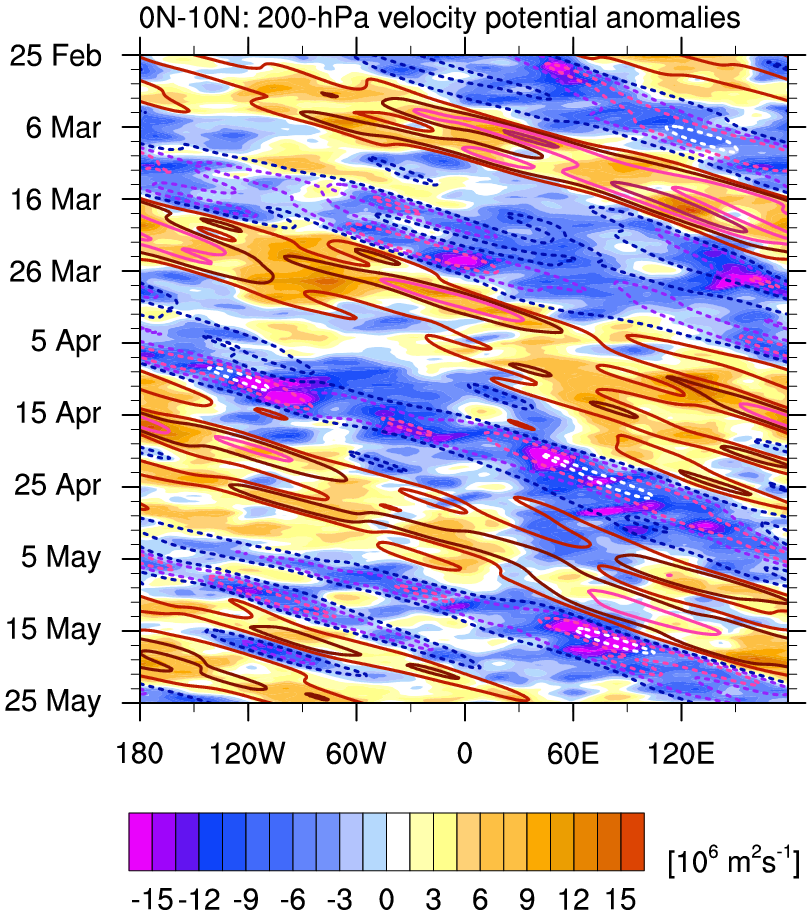

Kelvin filtered 200 hPa Velocity Potential
Convectively suppressed phase of the Kelvin wave: RED contours
Convectively active phase of the Kelvin wave: BLUE dashed contours
A Kelvin Wave is a type of low-frequency gravity wave trapped to a vertical boundary, or the equator, which propagates anticlockwise in our area of the world which translate to fluctuations in wind speed at the ocean surface at the Equator result in eastward propagating waves like is occurring now.

According to the NASA Hurricane and Severe Storm Sentinel , Also know as HS3, they have the current risk up to moderate to High, which means they give a 60% chance of 3 or more Hurricanes to develop over the next couple of weeks. Conditions over the Atlantic, should remain in a state favoring the genesis of new tropical cyclones. With the factors I mentioned above, the threat is definitely increasing for new genesis,in our part of the world.
Now, on the flip side.
The zonally-elongated ridge that provided us with a great pattern for easterly waves to cross the Atlantic is in the process of breaking down. Which means the easterly Atlantic waves that do develop, are very likely to be fish storms, which is good for the East Coast. Now, this would have no bearing on cyclone genesis and the impacts on the United Stated for storms, that would be in the Caribbean or the Gulf of Mexico or, storms that develop at a low latitude. In fact, this is where the danger lies.
One reason for the breakdown of the Sub-Tropical Ridges is a series of troughs that are going to be moving through the CONUS. The weather across much of the Mid-West and Eastern US is going to become much much cooler. This is not a good pattern to be in, when you have the atmosphere getting favorable for cyclone genesis. Should something develop, or get into the Western Caribbean or the Gulf, it would most likely travel North to Northeast, depending on the timing of the troughs.
Additionally, the models are showing consistent development of systems in the GOM, Caribbean, and the East Atlantic.


So to sum it up, things could get very interesting in the next week or so.
Last edited by emcf30 on Mon Aug 20, 2012 9:27 am; edited 6 times in total

emcf30- Posts : 975
Reputation : 10
Join date : 2012-07-16
Age : 93
Re: TROUBLE IN THE TROPICS, Coming Soon to a Body of Water near you.....
![]() by scouter534 Mon Aug 13, 2012 8:04 am
by scouter534 Mon Aug 13, 2012 8:04 am

scouter534- Posts : 128
Reputation : 1
Join date : 2012-07-16
Age : 62
Location : Pompano Beach, FL
Re: TROUBLE IN THE TROPICS, Coming Soon to a Body of Water near you.....
![]() by emcf30 Mon Aug 13, 2012 8:06 am
by emcf30 Mon Aug 13, 2012 8:06 am
emcf30- Posts : 975
Reputation : 10
Join date : 2012-07-16
Age : 93
Re: TROUBLE IN THE TROPICS, Coming Soon to a Body of Water near you.....
![]() by GrillinInTheEye Mon Aug 13, 2012 8:07 am
by GrillinInTheEye Mon Aug 13, 2012 8:07 am

GrillinInTheEye- Posts : 153
Reputation : 1
Join date : 2012-07-17
Age : 56
Re: TROUBLE IN THE TROPICS, Coming Soon to a Body of Water near you.....
![]() by emcf30 Mon Aug 13, 2012 8:11 am
by emcf30 Mon Aug 13, 2012 8:11 am


emcf30- Posts : 975
Reputation : 10
Join date : 2012-07-16
Age : 93
Re: TROUBLE IN THE TROPICS, Coming Soon to a Body of Water near you.....
![]() by emcf30 Mon Aug 13, 2012 8:11 am
by emcf30 Mon Aug 13, 2012 8:11 am
emcf30- Posts : 975
Reputation : 10
Join date : 2012-07-16
Age : 93
Re: TROUBLE IN THE TROPICS, Coming Soon to a Body of Water near you.....
![]() by Tropic Bunker Mon Aug 13, 2012 8:12 am
by Tropic Bunker Mon Aug 13, 2012 8:12 am

Tropic Bunker- Posts : 70
Reputation : 1
Join date : 2012-07-16
Age : 85
Location : Miami
Re: TROUBLE IN THE TROPICS, Coming Soon to a Body of Water near you.....
![]() by sangria Mon Aug 13, 2012 8:13 am
by sangria Mon Aug 13, 2012 8:13 am

sangria- Admin
- Posts : 2345
Reputation : 55
Join date : 2012-07-16
Re: TROUBLE IN THE TROPICS, Coming Soon to a Body of Water near you.....
![]() by Tropic Bunker Mon Aug 13, 2012 8:55 am
by Tropic Bunker Mon Aug 13, 2012 8:55 am

Tropic Bunker- Posts : 70
Reputation : 1
Join date : 2012-07-16
Age : 85
Location : Miami
Re: TROUBLE IN THE TROPICS, Coming Soon to a Body of Water near you.....
![]() by sangria Mon Aug 13, 2012 8:56 am
by sangria Mon Aug 13, 2012 8:56 am

A floater has been put back up on ex 07, as well

Looks like shear in front of him is favorable....

and has been dropping......

Lower convergence is increasing.....

and 850 Vorticity is looking better.....

Most recent 06Z surface analysis......

Tradewinds will be a large factor......maybe someone can post a comment regarding them, as I don't know where to locate the information...
sangria- Admin
- Posts : 2345
Reputation : 55
Join date : 2012-07-16
Re: TROUBLE IN THE TROPICS, Coming Soon to a Body of Water near you.....
![]() by sangria Mon Aug 13, 2012 10:34 am
by sangria Mon Aug 13, 2012 10:34 am
EL NIÑO/SOUTHERN OSCILLATION (ENSO) DIAGNOSTIC DISCUSSION
issued by
CLIMATE PREDICTION CENTER/NCEP/NWS
and the International Research Institute for Climate and Society
9 August 2012
ENSO Alert System Status: El Niño Watch
Synopsis: El Niño conditions are likely to develop during August or September 2012.
ENSO-neutral conditions continued during July 2012 despite above-average sea surface temperatures (SST) across the eastern Pacific Ocean (Fig. 1). Reflecting this warmth, most of the weekly Niño index values remained near or greater than +0.5°C (Fig. 2). The oceanic heat content anomalies (average temperature in the upper 300m of the ocean) also remained elevated during the month (Fig. 3), consistent with a large region of above-average temperatures at depth across the equatorial Pacific (Fig. 4). Although sub-surface and surface temperatures were above average, many aspects of the tropical atmosphere were inconsistent with El Niño conditions. Upper-level and low-level trade winds were near average along the equator, while tropical convection remained enhanced over Indonesia (Fig. 5). However, convection increased near and just west of the International Date Line, which may eventually reflect a progression towards El Niño. The lack of a clear atmospheric response to the positive oceanic anomalies indicates ongoing ENSO-neutral conditions.
Nearly all of the dynamical models favor the onset of El Niño beginning in July- September 2012 (Fig. 6). As in previous months, several statistical models predict ENSO-neutral conditions through the remainder of the year, but the average statistical forecast of Niño-3.4 increased compared to last month. Supported by model forecasts and the continued warmth across the Pacific Ocean, there is increased confidence for a weak-to-moderate El Niño during the Northern Hemisphere fall and winter 2012-13. El Niño conditions are likely to develop during August or September 2012 (see CPC/IRI consensus forecast).
This discussion is a consolidated effort of the National Oceanic and Atmospheric Administration (NOAA), NOAA’s National Weather Service, and their funded institutions. Oceanic and atmospheric conditions are updated weekly on the Climate Prediction Center web site (El Niño/La Niña Current Conditions and Expert Discussions). Forecasts for the evolution of El Niño/La Niña are updated monthly in the Forecast Forum section of CPC's Climate Diagnostics Bulletin. The next ENSO Diagnostics Discussion is scheduled for 6 September 2012. To receive an e-mail notification when the monthly ENSO Diagnostic Discussions are released, please send an e-mail message to: ncep.list.enso-update@noaa.gov.
Climate Prediction Center National Centers for Environmental Prediction NOAA/National Weather Service Camp Springs, MD 20746-4304[i]
sangria- Admin
- Posts : 2345
Reputation : 55
Join date : 2012-07-16
Re: TROUBLE IN THE TROPICS, Coming Soon to a Body of Water near you.....
![]() by emcf30 Mon Aug 13, 2012 11:25 am
by emcf30 Mon Aug 13, 2012 11:25 am
Tropic Bunker wrote:Kind of lost on the Kelvin, but I agree that the pattern is going to change with the cool down coming. We are almost to mid August and the threats should indeed be from the West Caribbean/ Gulf . It will be interesting to see what happens in around 14 days!
Ok, let me try to explain what the role of Kelvin Waves are in regards to Tropical Cyclone Genesis.
First of all there are 2 common types of Kelvin Waves and they are both gravity driven and non-dispersive. They are often excited by an an abrupt change in the overlying wind field, such as the shift in the trade winds at the start of El Niño. One being the Coastal Kelvin wave and the other being the Equatorial Kelvin wave.
In the Coastal Kelvin wave this is a very complicated formula of a bunch of this

which I am sure no one is interested in. But, I will try to explain in blogging terms. Remember when Ernesto was approaching the Yucatan Coastline I was saying there is a possibility that he could strengthen to a Cat 2 because of the land, and the angle in which he was making landfall, I was referencing to this. While the minimum central pressure issued by the National Hurricane Center was officially 980 hPa, one storm chaser, Josh Morgerman, was able to get into the eyewall of Ernesto, recording a minimum pressure of 975 hPa on a Kestrel 4500. I fully expected Ernesto to be upgraded during the Post Season Analysis. It has to do with the depth of the water and reduction of depth along coastlines. The formula deals with determining shallow-water gravity waves without the effect of Earth’s rotation and adding in the Coriols Effect. So the way I understand it is when a system approaches coastline with the right atmospheric conditions and sea depths, these boundaries or wave and create or enhance stronger storms. Coastal Kelvin waves have nothing to do with Hurricanes but can enhance the effects if the other conditions are favorable.
Now, what I mentioned above is a Positive Equatorial Kelvin Wave
(CCKWs) This essentially acts as a waveguide, causing disturbances to be trapped in the vicinity of the equator, and the equatorial Kelvin wave illustrates this fact because the equator acts analogously to a topographic boundary for both the Northern and Southern Hemispheres, making this wave very similar to the coastally-trapped Kelvin wave.

CCKWs in their active phase, which we are currently in. enhance convection through low-level convergence leading with upper level divergence following. A conceptual model of a kelvin wave reveals that the structure is tilted with the low-level convergence leading the upper level divergence.

Since the diagram above shows the upper level portion of the Kelvin Wave, we can probably expect to see the low-level portion ahead of this feature. One benefit tropical cyclones and developing disturbances alike experience from CCKW (aside from enhanced convection) is that the vertical wind shear is reduced in the wake of these features as the upper level easterlies (on the backside of the divergence) is enhanced, while the low-level easterlies are reduced. Thus, this might help to negate some of the negative westerly shear that the TUTT might impart on this feature. One other important piece of information needed when forecasting with these features is that CCKW are typically centered along the equator, which means their influence decreases the further poleward a feature is located. So the further South a wave gets, the better it will develop interacting with the CCKW. The Euro I posted this morning shows the storms are projected to develop much further to the South.
emcf30- Posts : 975
Reputation : 10
Join date : 2012-07-16
Age : 93
Re: TROUBLE IN THE TROPICS, Coming Soon to a Body of Water near you.....
![]() by Tropic Bunker Mon Aug 13, 2012 12:17 pm
by Tropic Bunker Mon Aug 13, 2012 12:17 pm
Tropic Bunker- Posts : 70
Reputation : 1
Join date : 2012-07-16
Age : 85
Location : Miami
Re: TROUBLE IN THE TROPICS, Coming Soon to a Body of Water near you.....
![]() by Seawall Mon Aug 13, 2012 1:21 pm
by Seawall Mon Aug 13, 2012 1:21 pm

Seawall- Posts : 125
Reputation : 3
Join date : 2012-07-16
Re: TROUBLE IN THE TROPICS, Coming Soon to a Body of Water near you.....
![]() by sangria Mon Aug 13, 2012 2:20 pm
by sangria Mon Aug 13, 2012 2:20 pm
sangria- Admin
- Posts : 2345
Reputation : 55
Join date : 2012-07-16
Re: TROUBLE IN THE TROPICS, Coming Soon to a Body of Water near you.....
![]() by StAugustineFL Mon Aug 13, 2012 3:48 pm
by StAugustineFL Mon Aug 13, 2012 3:48 pm


StAugustineFL- Posts : 2231
Reputation : 64
Join date : 2012-07-17
Re: TROUBLE IN THE TROPICS, Coming Soon to a Body of Water near you.....
![]() by emcf30 Mon Aug 13, 2012 4:52 pm
by emcf30 Mon Aug 13, 2012 4:52 pm
emcf30- Posts : 975
Reputation : 10
Join date : 2012-07-16
Age : 93
Re: TROUBLE IN THE TROPICS, Coming Soon to a Body of Water near you.....
![]() by emcf30 Mon Aug 13, 2012 4:57 pm
by emcf30 Mon Aug 13, 2012 4:57 pm
Tropic Bunker wrote:Wow e! Thanks for taking the time to explain it brother. I now have a better understanding of what it involves!!! You should have been a teacher.
Your Welcome Sea and Trop.
Well I do have an expired teaching certificate in my portfolio from the State of Florida. LOL.
A lot of people really don't realize all the pieces of the puzzle need to come together for Tropical Cyclone Genesis. Way more than I understand for sure.. These variables discussed in the blog today are only two small pieces of the puzzle, It not just a thunderstorm swirling across the warm waters that is needed for a system to be born............
emcf30- Posts : 975
Reputation : 10
Join date : 2012-07-16
Age : 93
Re: TROUBLE IN THE TROPICS, Coming Soon to a Body of Water near you.....
![]() by emcf30 Mon Aug 13, 2012 7:07 pm
by emcf30 Mon Aug 13, 2012 7:07 pm
Re-Running models on Ex TD7

WTF

* ATLANTIC SHIPS INTENSITY FORECAST *
* GOES AVAILABLE, OHC AVAILABLE *
* SEVEN AL072012 08/13/12 18 UTC *
TIME (HR) 0 6 12 18 24 36 48 60 72 84 96 108 120
V (KT) NO LAND 30 33 35 38 41 49 57 66 71 76 81 87 90
V (KT) LAND 30 33 35 38 41 40 36 30 28 27 27 27 27
V (KT) LGE mod 30 32 34 36 39 37 36 30 28 27 27 27 27
Storm Type TROP TROP TROP TROP TROP TROP TROP TROP TROP TROP TROP TROP TROP
SHEAR (KT) 16 13 12 9 8 1 5 5 7 8 8 13 13
SHEAR ADJ (KT) -7 -7 -3 -3 -4 0 0 -4 1 -1 0 -3 -2
SHEAR DIR 241 235 242 292 19 350 85 168 145 120 107 68 84
SST (C) 28.2 28.2 28.1 28.2 28.3 29.0 29.7 29.7 29.7 30.0 30.2 30.2 30.2
emcf30- Posts : 975
Reputation : 10
Join date : 2012-07-16
Age : 93
Re: TROUBLE IN THE TROPICS, Coming Soon to a Body of Water near you.....
![]() by emcf30 Tue Aug 14, 2012 5:19 pm
by emcf30 Tue Aug 14, 2012 5:19 pm
emcf30- Posts : 975
Reputation : 10
Join date : 2012-07-16
Age : 93
Re: TROUBLE IN THE TROPICS, Coming Soon to a Body of Water near you.....
![]() by StAugustineFL Tue Aug 14, 2012 5:46 pm
by StAugustineFL Tue Aug 14, 2012 5:46 pm

StAugustineFL- Posts : 2231
Reputation : 64
Join date : 2012-07-17
Re: TROUBLE IN THE TROPICS, Coming Soon to a Body of Water near you.....
![]() by sangria Tue Aug 14, 2012 7:57 pm
by sangria Tue Aug 14, 2012 7:57 pm

sangria- Admin
- Posts : 2345
Reputation : 55
Join date : 2012-07-16
Re: TROUBLE IN THE TROPICS, Coming Soon to a Body of Water near you.....
![]() by emcf30 Wed Aug 15, 2012 7:39 am
by emcf30 Wed Aug 15, 2012 7:39 am
TROPICAL WEATHER OUTLOOK
NWS NATIONAL HURRICANE CENTER MIAMI FL
800 AM EDT WED AUG 15 2012
FOR THE NORTH ATLANTIC...CARIBBEAN SEA AND THE GULF OF MEXICO...
1. A LOW PRESSURE SYSTEM LOCATED OVER THE CENTRAL ATLANTIC ABOUT
715 MILES EAST-SOUTHEAST OF BERMUDA IS GRADUALLY BECOMING BETTER
DEFINED. SHOWER AND THUNDERSTORM ACTIVITY HAS INCREASED OVER THE
PAST SEVERAL HOURS...AND IF THIS TREND CONTINUES A TROPICAL
DEPRESSION COULD FORM LATER TODAY. THIS SYSTEM HAS A HIGH
CHANCE...80 PERCENT...OF BECOMING A TROPICAL CYCLONE DURING THE
NEXT 48 HOURS AS IT MOVES NORTH-NORTHWESTWARD AT 15 MPH TODAY...AND
TURNS NORTHEASTWARD BY THURSDAY.
2. A TROPICAL WAVE...THE REMNANTS OF TROPICAL DEPRESSION SEVEN...IS
LOCATED OVER WESTERN HONDURAS AND THE COAST OF BELIZE. THIS
DISTURBANCE IS PRODUCING DISORGANIZED SHOWERS AND THUNDERSTORMS
OVER THE FAR NORTHWESTERN CARIBBEAN SEA...PORTIONS OF CENTRAL
AMERICA...AND THE YUCATAN PENINSULA. THIS SYSTEM HAS A LOW
CHANCE...NEAR 0 PERCENT...OF BECOMING A TROPICAL CYCLONE DURING THE
NEXT 48 HOURS AS IT MOVES WEST-NORTHWESTWARD AT 15 TO 20 MPH.
HOWEVER...LOCALLY HEAVY RAINS WILL BE POSSIBLE ACROSS PORTIONS OF
CENTRAL AMERICA AND SOUTHERN MEXICO THROUGH THURSDAY.
ELSEWHERE...TROPICAL CYCLONE FORMATION IS NOT EXPECTED DURING THE
NEXT 48 HOURS.
$$
FORECASTER STEWART
NNNN

emcf30- Posts : 975
Reputation : 10
Join date : 2012-07-16
Age : 93
Re: TROUBLE IN THE TROPICS, Coming Soon to a Body of Water near you.....
![]() by emcf30 Wed Aug 15, 2012 7:40 am
by emcf30 Wed Aug 15, 2012 7:40 am
emcf30- Posts : 975
Reputation : 10
Join date : 2012-07-16
Age : 93
Re: TROUBLE IN THE TROPICS, Coming Soon to a Body of Water near you.....
![]() by scouter534 Wed Aug 15, 2012 8:18 am
by scouter534 Wed Aug 15, 2012 8:18 am
scouter534- Posts : 128
Reputation : 1
Join date : 2012-07-16
Age : 62
Location : Pompano Beach, FL
Re: TROUBLE IN THE TROPICS, Coming Soon to a Body of Water near you.....
![]() by Tropic Bunker Wed Aug 15, 2012 8:34 am
by Tropic Bunker Wed Aug 15, 2012 8:34 am
Tropic Bunker- Posts : 70
Reputation : 1
Join date : 2012-07-16
Age : 85
Location : Miami
Re: TROUBLE IN THE TROPICS, Coming Soon to a Body of Water near you.....
![]() by sangria Wed Aug 15, 2012 10:52 am
by sangria Wed Aug 15, 2012 10:52 am
Trop, my little ole wave is a mischief maker.....but, looks like the only thing it's doing this morning, is spitting out a lot of rain!! It will be interesting to watch it's remnants over the next day, to see if some energy gets pulled to the north.
sangria- Admin
- Posts : 2345
Reputation : 55
Join date : 2012-07-16
Re: TROUBLE IN THE TROPICS, Coming Soon to a Body of Water near you.....
![]() by emcf30 Wed Aug 15, 2012 11:05 am
by emcf30 Wed Aug 15, 2012 11:05 am


ECMWF picking up on some mischief in the Western GOM now.

Something to watch, It has been a on and off again forecast from the GFS.
emcf30- Posts : 975
Reputation : 10
Join date : 2012-07-16
Age : 93
Re: TROUBLE IN THE TROPICS, Coming Soon to a Body of Water near you.....
![]() by sangria Wed Aug 15, 2012 11:39 am
by sangria Wed Aug 15, 2012 11:39 am

sangria- Admin
- Posts : 2345
Reputation : 55
Join date : 2012-07-16
Re: TROUBLE IN THE TROPICS, Coming Soon to a Body of Water near you.....
![]() by StAugustineFL Wed Aug 15, 2012 12:53 pm
by StAugustineFL Wed Aug 15, 2012 12:53 pm
12Z GFS has something festering in the south TX/Mexico region for days.
StAugustineFL- Posts : 2231
Reputation : 64
Join date : 2012-07-17
Re: TROUBLE IN THE TROPICS, Coming Soon to a Body of Water near you.....
![]() by emcf30 Wed Aug 15, 2012 1:22 pm
by emcf30 Wed Aug 15, 2012 1:22 pm

emcf30- Posts : 975
Reputation : 10
Join date : 2012-07-16
Age : 93
Re: TROUBLE IN THE TROPICS, Coming Soon to a Body of Water near you.....
![]() by sangria Wed Aug 15, 2012 1:24 pm
by sangria Wed Aug 15, 2012 1:24 pm
sangria- Admin
- Posts : 2345
Reputation : 55
Join date : 2012-07-16
Re: TROUBLE IN THE TROPICS, Coming Soon to a Body of Water near you.....
![]() by StAugustineFL Wed Aug 15, 2012 1:46 pm
by StAugustineFL Wed Aug 15, 2012 1:46 pm

1. A WELL-DEFINED LOW PRESSURE SYSTEM IS LOCATED OVER THE CENTRAL
ATLANTIC ABOUT 630 MILES EAST-SOUTHEAST OF BERMUDA. SHOWER AND
THUNDERSTORM ACTIVITY CONTINUES TO SHOW SIGNS OF ORGANIZATION...
AND A TROPICAL DEPRESSION COULD FORM LATER TODAY. THIS SYSTEM
HAS A HIGH CHANCE...90 PERCENT...OF BECOMING A TROPICAL CYCLONE
DURING THE NEXT 48 HOURS AS IT MOVES NORTH-NORTHWESTWARD TO
NORTHWARD AT 15 MPH TODAY...AND TURNS NORTHEASTWARD TOMORROW.
StAugustineFL- Posts : 2231
Reputation : 64
Join date : 2012-07-17
Re: TROUBLE IN THE TROPICS, Coming Soon to a Body of Water near you.....
![]() by sangria Wed Aug 15, 2012 1:48 pm
by sangria Wed Aug 15, 2012 1:48 pm
BULLETIN - EAS ACTIVATION REQUESTED
TORNADO WARNING
NATIONAL WEATHER SERVICE NEWPORT/MOREHEAD CITY NC
129 PM EDT WED AUG 15 2012
THE NATIONAL WEATHER SERVICE IN NEWPORT HAS ISSUED A
* TORNADO WARNING FOR...
PAMLICO COUNTY IN NORTH CAROLINA
CENTRAL CRAVEN COUNTY IN EASTERN NORTH CAROLINA
* UNTIL 215 PM EDT
* AT 126 PM EDT...NATIONAL WEATHER SERVICE DOPPLER RADAR INDICATED A
TORNADO OVER FAIRFIELD HARBOR...OR 6 MILES EAST OF JAMES CITY...
MOVING NORTHEAST AT 20 MPH.
* LOCATIONS IMPACTED INCLUDE...
ARAPAHOE...
GRANTSBORO...
ALLIANCE...
BAYBORO...
MERRITT...STONEWALL...
MARIBEL...
sangria- Admin
- Posts : 2345
Reputation : 55
Join date : 2012-07-16
Re: TROUBLE IN THE TROPICS, Coming Soon to a Body of Water near you.....
![]() by emcf30 Wed Aug 15, 2012 4:15 pm
by emcf30 Wed Aug 15, 2012 4:15 pm
BEGIN
NHC_ATCF
invest_RENUMBER_al932012_al082012.ren
FSTDA
R
U
040
010
0000
201208151933
NONE
NOTIFY=ATRP


emcf30- Posts : 975
Reputation : 10
Join date : 2012-07-16
Age : 93
Re: TROUBLE IN THE TROPICS, Coming Soon to a Body of Water near you.....
![]() by sangria Wed Aug 15, 2012 4:56 pm
by sangria Wed Aug 15, 2012 4:56 pm
* ATLANTIC SHIPS INTENSITY FORECAST *
* GOES AVAILABLE, OHC AVAILABLE *
* SEVEN AL072012 08/15/12 18 UTC *
TIME (HR) 0 6 12 18 24 36 48 60 72 84 96 108 120
V (KT) NO LAND 25 25 26 28 30 35 44 51 56 61 65 69 71
V (KT) LAND 25 26 26 26 27 31 40 47 52 57 61 65 67
V (KT) LGE mod 25 26 26 26 27 31 35 40 48 57 64 70 73
Storm Type TROP TROP TROP TROP TROP TROP TROP TROP TROP TROP TROP TROP TROP
SHEAR (KT) 5 10 10 7 7 5 1 14 11 17 10 18 6
SHEAR ADJ (KT) 0 -4 -4 -3 0 0 0 -2 -1 0 2 4 6
SHEAR DIR 122 151 177 197 211 269 19 296 318 307 308 305 307
SST (C) 29.7 29.7 29.7 29.6 29.5 29.4 29.5 29.7 29.7 29.5 29.3 29.3 29.3
POT. INT. (KT) 165 164 164 161 159 156 158 162 162 158 154 153 153
ADJ. POT. INT. 164 161 157 151 147 143 143 146 145 141 133 131 131
200 MB T (C) -53.5 -53.2 -53.2 -53.4 -53.1 -53.0 -53.2 -53.0 -53.3 -52.8 -52.9 -52.6 -52.5
TH_E DEV (C) 10 10 9 8 10 9 11 11 11 12 12 12 11
700-500 MB RH 68 69 69 69 69 72 71 70 70 64 66 70 68
GFS VTEX (KT) 0 LOST LOST LOST LOST LOST LOST LOST LOST LOST LOST LOST LOST
850 MB ENV VOR 34 25 19 4 -5 -6 -2 2 15 19 13 27 20
200 MB DIV 24 21 16 12 4 29 15 15 45 49 51 34 52
700-850 TADV 0 3 -2 -3 1 -4 -2 -2 3 4 4 14 7
LAND (KM) -86 -208 -166 -117 -57 19 49 83 79 56 52 61 102
LAT (DEG N) 16.1 xx.x xx.x xx.x xx.x xx.x xx.x xx.x xx.x xx.x xx.x xx.x xx.x
LONG(DEG W) 89.8 xxx.x xxx.x xxx.x xxx.x xxx.x xxx.x xxx.x xxx.x xxx.x xxx.x xxx.x xxx.x
STM SPEED (KT) 13 11 9 7 6 5 5 5 5 6 3 2 2
HEAT CONTENT 0 0 45 0 26 19 33 45 53 56 51 55 61

sangria- Admin
- Posts : 2345
Reputation : 55
Join date : 2012-07-16
Re: TROUBLE IN THE TROPICS, Coming Soon to a Body of Water near you.....
![]() by emcf30 Wed Aug 15, 2012 5:46 pm
by emcf30 Wed Aug 15, 2012 5:46 pm
Don't understand why anyone is even running models on this. It is inland, and has been for some time. Not even projected to get back over water.

Now, what the models are picking up on in a piece of energy from this wave, Not ExTD7, to get hooked up with a piece of energy from a cold front in a few days and possibly develop into something.
emcf30- Posts : 975
Reputation : 10
Join date : 2012-07-16
Age : 93
Re: TROUBLE IN THE TROPICS, Coming Soon to a Body of Water near you.....
![]() by emcf30 Wed Aug 15, 2012 9:44 pm
by emcf30 Wed Aug 15, 2012 9:44 pm

emcf30- Posts : 975
Reputation : 10
Join date : 2012-07-16
Age : 93
Re: TROUBLE IN THE TROPICS, Coming Soon to a Body of Water near you.....
![]() by emcf30 Thu Aug 16, 2012 5:40 am
by emcf30 Thu Aug 16, 2012 5:40 am


* ATLANTIC SHIPS INTENSITY FORECAST *
* GOES AVAILABLE, OHC AVAILABLE *
* GORDON AL082012 08/16/12 06 UTC *
TIME (HR) 0 6 12 18 24 36 48 60 72 84 96 108 120
V (KT) NO LAND 35 38 42 46 51 59 66 68 68 65 57 52 43
V (KT) LAND 35 38 42 46 51 59 66 68 68 65 57 52 43
V (KT) LGE mod 35 38 40 43 46 52 59 63 61 56 49 43 40
Storm Type TROP TROP TROP TROP TROP TROP TROP TROP TROP TROP EXTP EXTP EXTP
SHEAR (KT) 9 7 3 2 8 12 19 25 38 46 45 43 52
SHEAR ADJ (KT) -4 -4 -2 0 -3 -2 -5 6 3 4 0 0 -2
SHEAR DIR 170 199 182 230 251 284 285 265 259 248 249 251 242
SST (C) 27.5 27.4 27.1 26.7 26.3 26.2 26.7 26.3 25.3 24.6 23.2 22.6 21.6
emcf30- Posts : 975
Reputation : 10
Join date : 2012-07-16
Age : 93
Re: TROUBLE IN THE TROPICS, Coming Soon to a Body of Water near you.....
![]() by emcf30 Thu Aug 16, 2012 7:47 am
by emcf30 Thu Aug 16, 2012 7:47 am
Currently, we have a wave axis sitting inland over Honduras, Belize, and Mexico. This is Ex-TD7.
The convection associated with this tropical wave is strung out and not consolidated at any particular spot.

Conditions in the Western GOM is NOT conducive for any type of development at the moment.
There is currently a large ULL spinning in the Western GOM which is producing a lot of shear in that region. It is predicted that this ULL will begin to dissipate and move out of the way in the nest couple of days.
The key to any developpment is weather or not the Low Level Vorticity that is currently over land will be able to make its way off into the BOC or GOM.
Also, it will be interesting to see if the current small upper level ridge will be able to tag along and progress with the Tropical Wave Axis as it tries to move into the GOM.
If this can happen, it would replace what is let of the ULL and make conditions conducive for Development at that time. This seems to be the tendency at this time.

The models are certainly supporting this idea of tropical cyclone development in the Western Gulf in the coming days.


One of the possibilities is that the Low will form just inland over the Mexican Coast. The models have been back and forth with this idea for days now. I believe that IF something were to develop in the Western GOM it will feel the effects of a trough and move more to the North and North East ahead of the dominate flow in the area.

emcf30- Posts : 975
Reputation : 10
Join date : 2012-07-16
Age : 93
Re: TROUBLE IN THE TROPICS, Coming Soon to a Body of Water near you.....
![]() by sangria Thu Aug 16, 2012 7:54 am
by sangria Thu Aug 16, 2012 7:54 am
1. A TROPICAL WAVE...THE REMNANTS OF TROPICAL DEPRESSION SEVEN...IS
LOCATED OVER SOUTHEASTERN MEXICO AND THE WESTERN YUCATAN PENINSULA.
THIS DISTURBANCE IS PRODUCING DISORGANIZED SHOWERS AND THUNDERSTORMS
OVER THE BAY OF CAMPECHE...THE YUCATAN PENINSULA...SOUTHEASTERN
MEXICO...AND GUATEMALA. ALTHOUGH THERE IS CURRENTLY ONLY A SLIGHT
CHANCE OF REGENERATION WHEN THE WAVE EMERGES OVER THE BAY OF
CAMPECHE...LOCALLY HEAVY RAIN IS POSSIBLE ACROSS PORTIONS OF
CENTRAL AMERICA AND SOUTHERN MEXICO THROUGH LATE TODAY. THIS
SYSTEM HAS A LOW CHANCE...10 PERCENT...OF BECOMING A TROPICAL
CYCLONE DURING THE NEXT 48 HOURS AS IT MOVES WEST-NORTHWESTWARD AT
ABOUT 15 MPH.
sangria- Admin
- Posts : 2345
Reputation : 55
Join date : 2012-07-16
Severe Weather Outlook
![]() by emcf30 Thu Aug 16, 2012 8:40 am
by emcf30 Thu Aug 16, 2012 8:40 am
SEVERE WEATHER
Today promises to be a wild weather day across the Midwest as a strong cold front dives South and East.Thunder storms areas already booming this morning across Iowa, Wisconsin and Nebraska. Wind gusts to 60 mph with hail the size of quarters have already been reported in some of these areas today.

The main threats with these potent storms will be damaging blast of wind, more quarter-sized hail and vivid, dangerous lightning.
Here is a look at the SPC Convective Outlook

...THERE IS A SLGT RISK OF SVR TSTMS FROM LOWER MI SWWD INTO SERN
KS/NERN OK...
...SYNOPSIS...
WITHIN THE BROAD WRN RIDGE/ERN TROUGH PATTERN PREVAILING ACROSS THE
CONUS...A STRONG SHORT-WAVE TROUGH IS FORECAST TO MOVE ACROSS THE
UPPER GREAT LAKES REGION THIS PERIOD...IN THE WAKE OF AN INITIAL
SYSTEM WHICH WILL BE SHIFTING NEWD ALONG THE NEW ENGLAND COAST
TOWARD THE CANADIAN MARITIMES.
IN RESPONSE TO THE ADVANCE OF THE N CENTRAL U.S. TROUGH...A SURFACE
COLD FRONT IS FORECAST TO MOVE STEADILY EWD ACROSS THE MIDWEST/OH
VALLEY AND EVENTUALLY INTO THE LOWER GREAT LAKES...WHILE MAKING
SLOWER SWD PROGRESS ACROSS MO/KS/OK THROUGH THE END OF THE PERIOD.
THIS FRONT AND ASSOCIATED UPPER SYSTEM WILL FOCUS THE PRIMARY AREA
OF SEVERE/CONVECTIVE POTENTIAL THIS PERIOD.
...LOWER MI SWWD INTO SERN KS/NERN OK...
SCATTERED ONGOING STORMS ALONG THE COLD FRONT SHOULD
CONTINUE/INCREASE IN COVERAGE INTO MID AFTERNOON...AS HEATING OF A
SEASONABLY-MOIST PRE-FRONTAL BOUNDARY LAYER RESULTS IN MODERATE
DESTABILIZATION. AS THE LEADING EDGE OF A ZONE OF MODERATELY STRONG
FLOW ALOFT -- PARTICULARLY FROM MO NEWD -- SPREADS ATOP THE SURFACE
FRONTAL ZONE...SHEAR AND INSTABILITY WILL BECOME SUFFICIENT TO
SUPPORT AN ELONGATED ZONE OF DAMAGING WIND/HAIL THREAT. THE NERN
AND SWRN EXTENTS OF THIS ZONE REMAIN SOMEWHAT UNCERTAIN...WITH
QUESTIONS REGARDING DESTABILIZATION POTENTIAL ACROSS LOWER MI AND
FAIRLY WEAK FLOW EXPECTED FROM MO SWWD. STILL...WILL EXPAND THE
SLIGHT RISK A BIT IN BOTH DIRECTIONS THIS FORECAST -- WITH STRONG
FLOW ALOFT ACROSS MI AND A DEEP DRY BOUNDARY LAYER EXPECTED ACROSS
OK WARRANTING AN INCREASE IN SEVERE PROBABILITY IN BOTH AREAS.
THREAT MAY CONTINUE THROUGH THE EVENING AND INTO THE OVERNIGHT HOURS
-- PARTICULARLY INTO THE TN/LOWER MS VALLEY/CENTRAL GULF COAST
REGIONS WHERE GREATER INSTABILITY SHOULD LINGER AFTER DARK.
THUS...WILL MAINTAIN A SEWD EXTENSION OF LOW-PROBABILITY THREAT AS
FAR SE AS THE CENTRAL GULF COAST.
..GOSS/COHEN.. 08/16/2012
CLICK TO GET WUUS01 PTSDY1 PRODUCT
Now, on the Flip side of the Severe Weather
COOLER WEATHER
Yes, you saw that right, much, much cooler weather is moving in to the North Central U.S. This abrupt change to a fall-like pattern will continue through the end of the week before temperatures slowly begin to rebound by Sunday.
This advancing cold front will replace summer temperatures across the Northern Plains with crisp, cool air mass today. Strong, gusty northwest winds behind the front will help usher in the cooler temperatures. Once the cold front moves through, high pressure will build in, providing clear nights and sunny days. High temperatures only reach into 60s and 70s Montana, Wyoming, the Dakotas and Minnesota , which for once, will be well below normal for this time of year.The Northern Rockies will need to put a log on the fire tonight and Friday night as temperatures dip well into the 30s.
This cold front will continue to charge eastward into the Midwest bringing showers, thunderstorms and cooler air to many major Midwestern cities later today and Friday. Morning temperatures will be in the 40s and 50s across Iowa, Illinois and Indiana Friday through Sunday. High will remain only in the 60's and 70's.
The front won`t stop there and will set its sights on the Northeast Friday. Ahead of the front, showers and thunderstorms will rumble through Friday and eventually push offshore. This will leave the Northeast and parts of the mid-Atlantic in a cooler pattern with highs in 70s on Saturday. What a huge difference of the 100 plus temperatures experienced in these areas this year so far.
A big Jason WOW
emcf30- Posts : 975
Reputation : 10
Join date : 2012-07-16
Age : 93
Re: TROUBLE IN THE TROPICS, Coming Soon to a Body of Water near you.....
![]() by StAugustineFL Thu Aug 16, 2012 9:03 am
by StAugustineFL Thu Aug 16, 2012 9:03 am
The remnants of Tropical Depression #7 were located over the Yucatan Peninsula this morning. These remnants were producing showers and thunderstorms across much of the western Caribbean, the Yucatan Peninsula and parts of Central America. I expect that this system will move into the Bay of Campeche by tonight where it has the potential to become a tropical cyclone this weekend or early next week in the western Gulf of Mexico.
As for this morning’s forecast guidance, the European model seems to agree with the GFS model in developing a tropical cyclone in the western Gulf of Mexico right around the Sunday/Monday timeframe. Now, the GFS model gradually pulls this system inland into northern Mexico and southern Texas by later next week while the European model forecasts a northward track towards southeastern Louisiana by next Friday.
The latest Canadian model guidance also seems to suggest development into a tropical storm by Tuesday and Wednesday of next week and forecasts it to come ashore in south Texas by next Thursday. The experimental FIM model forecasts development into a tropical storm very close to the coast of northeastern Mexico on Monday with the FIM model forecasting it to come ashore right near the Texas-Mexico border on Wednesday.
So, now here are my thoughts: I do think that we will see the remnants of Tropical Depression #7 emerge in the Bay of Campeche sometime before midnight this evening and I think a general west-northwestward track across the Bay of Campeche and towards northeastern Mexico and south Texas seems quite possible this weekend into early next week. Environmental conditions are expected to be favorable enough to support tropical storm development sometime between Sunday and Tuesday. I do think that this could be a situation where a tropical storm develops very close to the coast of northern Mexico and south Texas and those of you in south Texas from about Corpus Christi to Brownsville should keep close tabs on this potential during this upcoming weekend.
Heavy rainfall is likely once we get into next week across much of coastal Texas with amounts of up to 3 to 5 inches from Beaumont to Houston and up to 10 to 14 inches from Corpus Christi to Brownsville.
StAugustineFL- Posts : 2231
Reputation : 64
Join date : 2012-07-17
Re: TROUBLE IN THE TROPICS, Coming Soon to a Body of Water near you.....
![]() by Seawall Thu Aug 16, 2012 9:22 am
by Seawall Thu Aug 16, 2012 9:22 am
Seawall- Posts : 125
Reputation : 3
Join date : 2012-07-16
Re: TROUBLE IN THE TROPICS, Coming Soon to a Body of Water near you.....
![]() by Tropic Bunker Thu Aug 16, 2012 10:17 am
by Tropic Bunker Thu Aug 16, 2012 10:17 am
Why aren't all this people calling Ex-TD7 Ex-Sans Wave????
Tropic Bunker- Posts : 70
Reputation : 1
Join date : 2012-07-16
Age : 85
Location : Miami
Re: TROUBLE IN THE TROPICS, Coming Soon to a Body of Water near you.....
![]() by emcf30 Thu Aug 16, 2012 10:20 am
by emcf30 Thu Aug 16, 2012 10:20 am
Tropic Bunker wrote:Interested to see what the early cold front will cause today!
Why aren't all this people calling Ex-TD7 Ex-Sans Wave????
Because your on the wrong site...LOL
emcf30- Posts : 975
Reputation : 10
Join date : 2012-07-16
Age : 93
Re: TROUBLE IN THE TROPICS, Coming Soon to a Body of Water near you.....
![]() by Tropic Bunker Thu Aug 16, 2012 10:36 am
by Tropic Bunker Thu Aug 16, 2012 10:36 am
Tropic Bunker- Posts : 70
Reputation : 1
Join date : 2012-07-16
Age : 85
Location : Miami
Re: TROUBLE IN THE TROPICS, Coming Soon to a Body of Water near you.....
![]() by emcf30 Thu Aug 16, 2012 11:31 am
by emcf30 Thu Aug 16, 2012 11:31 am


emcf30- Posts : 975
Reputation : 10
Join date : 2012-07-16
Age : 93
Re: TROUBLE IN THE TROPICS, Coming Soon to a Body of Water near you.....
![]() by sangria Thu Aug 16, 2012 1:11 pm
by sangria Thu Aug 16, 2012 1:11 pm
Tropic Bunker wrote:Interested to see what the early cold front will cause today!
Why aren't all this people calling Ex-TD7 Ex-Sans Wave????
emcf30 wrote:Tropic Bunker wrote:Interested to see what the early cold front will cause today!
Why aren't all this people calling Ex-TD7 Ex-Sans Wave????
Because your on the wrong site...LOL
Tropic Bunker wrote:LOL, just trying to give my BFF credit for being persistent!
LMAO.......you will eat Crow e!!!! And, thank you, BFF!
sangria- Admin
- Posts : 2345
Reputation : 55
Join date : 2012-07-16
Re: TROUBLE IN THE TROPICS, Coming Soon to a Body of Water near you.....
![]() by emcf30 Thu Aug 16, 2012 2:37 pm
by emcf30 Thu Aug 16, 2012 2:37 pm
I think the chances of genesis of this wave Pouch 15L, are high during the upcoming week. The IR image below shows the nice interaction with the wave and the diurnal cycle of convection.

This wave caused a tremendous amount of flooding and storm related damage and dozens of fatalities as it crossed Africa. As mentioned 3 days ago, we are also observing the passage of the strong eastward propagating convectively-coupled Kelvin wave over the Atlantic. Here is the latest


All the signs are there for development of this wave.

Infact, I am going to go out on the limb and say, Pouch 15L will be the first Major Hurricane of the 2012 Atlantic Season based on the conditions that have been outlined in this blog. The signals have been strong for quite a few days now that would support this. Now, we will see how the models handle this in the next 2 days or so.
emcf30- Posts : 975
Reputation : 10
Join date : 2012-07-16
Age : 93
Sponsored content
Page 1 of 3 • 1, 2, 3 ![]()
» Tropics Tonight
» Next Trouble Maker
» Eyes on the Tropics and More Severe Weather
» Tracking Season is Coming


» summer 2019 hurricane season
» April-May Florida weather and local events etc
» NASCAR 2019
» Late January through February outlook
» FLORIDA/ALABAMA AND THE HOLIDAY SEASON WEATHER
» NASCAR 2018
» CLOSED Florida/Alabama Blog - October Tropical Mischief