


CLOSED Florida weather and Tropical season weather
:: Florida Blog
Page 4 of 9 •  1, 2, 3, 4, 5, 6, 7, 8, 9
 ![]()
Re: CLOSED Florida weather and Tropical season weather
![]() by BillsfaninSoFla Mon Jun 19, 2017 2:56 pm
by BillsfaninSoFla Mon Jun 19, 2017 2:56 pm
BillsfaninSoFla- Posts : 1966
Reputation : 52
Join date : 2017-03-05
Re: CLOSED Florida weather and Tropical season weather
![]() by LargoFL Mon Jun 19, 2017 2:57 pm
by LargoFL Mon Jun 19, 2017 2:57 pm
yes for sure Billsfan, storm line getting real close to me now.BillsfaninSoFla wrote:Some nasty storms going on today.

LargoFL- Posts : 10724
Reputation : 130
Join date : 2017-03-05

LargoFL- Posts : 10724
Reputation : 130
Join date : 2017-03-05
Re: CLOSED Florida weather and Tropical season weather
![]() by LargoFL Mon Jun 19, 2017 3:02 pm
by LargoFL Mon Jun 19, 2017 3:02 pm

LargoFL- Posts : 10724
Reputation : 130
Join date : 2017-03-05
Re: CLOSED Florida weather and Tropical season weather
![]() by LargoFL Mon Jun 19, 2017 3:07 pm
by LargoFL Mon Jun 19, 2017 3:07 pm
LargoFL- Posts : 10724
Reputation : 130
Join date : 2017-03-05

LargoFL- Posts : 10724
Reputation : 130
Join date : 2017-03-05

LargoFL- Posts : 10724
Reputation : 130
Join date : 2017-03-05
Re: CLOSED Florida weather and Tropical season weather
![]() by LargoFL Mon Jun 19, 2017 3:14 pm
by LargoFL Mon Jun 19, 2017 3:14 pm

LargoFL- Posts : 10724
Reputation : 130
Join date : 2017-03-05
Re: CLOSED Florida weather and Tropical season weather
![]() by LargoFL Mon Jun 19, 2017 3:34 pm
by LargoFL Mon Jun 19, 2017 3:34 pm
Special Weather Statement
National Weather Service Jacksonville FL
312 PM EDT MON JUN 19 2017
FLZ040-191945-
Marion FL-
312 PM EDT MON JUN 19 2017
...SIGNIFICANT WEATHER ADVISORY FOR CENTRAL MARION COUNTY UNTIL 345
PM EDT...
At 310 PM EDT, Doppler radar was tracking strong thunderstorms
centered near Lynne, moving north at 35 mph.
Wind gusts of 35 to 50 mph can be expected along with possible minor
wind damage.
Locations impacted include...
Ocala, Fort McCoy, Juniper Springs, Lynne, Sparr, Anthony, Ocklawaha,
Moss Bluff, Silver Springs Shores and Santos.
PRECAUTIONARY/PREPAREDNESS ACTIONS...
Torrential rainfall is also occurring with these storm, and may lead
to localized flooding. Do not drive your vehicle through flooded
roadways.
&&
LAT...LON 2897 8216 2920 8227 2941 8210 2938 8177
2913 8164
TIME...MOT...LOC 1910Z 161DEG 31KT 2919 8198
$$
ZIBURA
LargoFL- Posts : 10724
Reputation : 130
Join date : 2017-03-05
Re: CLOSED Florida weather and Tropical season weather
![]() by LargoFL Mon Jun 19, 2017 3:35 pm
by LargoFL Mon Jun 19, 2017 3:35 pm
LargoFL- Posts : 10724
Reputation : 130
Join date : 2017-03-05
Re: CLOSED Florida weather and Tropical season weather
![]() by LargoFL Mon Jun 19, 2017 3:36 pm
by LargoFL Mon Jun 19, 2017 3:36 pm
LargoFL- Posts : 10724
Reputation : 130
Join date : 2017-03-05
Re: CLOSED Florida weather and Tropical season weather
![]() by sangria Mon Jun 19, 2017 4:17 pm
by sangria Mon Jun 19, 2017 4:17 pm
LargoFL wrote:San...the line of storms is getting closer to you,stay alert ok.....................
Thanks Largo!
The wind picked up before the line hit. Another nice dumping of rain here.
I was in Homosassa yesterday and drove home around 5ish - I hit a flippin monsoonal rain storm right at the Hernando/Pasco county line. I almost pulled over at one point because I couldn't see jack in front of me.

sangria- Admin
- Posts : 2345
Reputation : 55
Join date : 2012-07-16
Re: CLOSED Florida weather and Tropical season weather
![]() by StAugustineFL Mon Jun 19, 2017 4:23 pm
by StAugustineFL Mon Jun 19, 2017 4:23 pm
Had a 10 minute downpour here earlier. Been an on/off light drip the past hour or two and looks to continue that way for a spell. My rain gauge had .55" at last check.

StAugustineFL- Posts : 2231
Reputation : 64
Join date : 2012-07-17
Re: CLOSED Florida weather and Tropical season weather
![]() by StAugustineFL Mon Jun 19, 2017 4:24 pm
by StAugustineFL Mon Jun 19, 2017 4:24 pm
sangria wrote:LargoFL wrote:San...the line of storms is getting closer to you,stay alert ok.....................
Thanks Largo!
The wind picked up before the line hit. Another nice dumping of rain here.
I was in Homosassa yesterday and drove home around 5ish - I hit a flippin monsoonal rain storm right at the Hernando/Pasco county line. I almost pulled over at one point because I couldn't see jack in front of me.
Did you see Jill?
StAugustineFL- Posts : 2231
Reputation : 64
Join date : 2012-07-17
Re: CLOSED Florida weather and Tropical season weather
![]() by sangria Mon Jun 19, 2017 4:47 pm
by sangria Mon Jun 19, 2017 4:47 pm
StAugustineFL wrote:
Did you see Jill?

sangria- Admin
- Posts : 2345
Reputation : 55
Join date : 2012-07-16
Re: CLOSED Florida weather and Tropical season weather
![]() by BillsfaninSoFla Mon Jun 19, 2017 5:32 pm
by BillsfaninSoFla Mon Jun 19, 2017 5:32 pm
BillsfaninSoFla- Posts : 1966
Reputation : 52
Join date : 2017-03-05
Re: CLOSED Florida weather and Tropical season weather
![]() by BillsfaninSoFla Mon Jun 19, 2017 6:41 pm
by BillsfaninSoFla Mon Jun 19, 2017 6:41 pm
BillsfaninSoFla- Posts : 1966
Reputation : 52
Join date : 2017-03-05
Re: CLOSED Florida weather and Tropical season weather
![]() by LargoFL Tue Jun 20, 2017 5:04 am
by LargoFL Tue Jun 20, 2017 5:04 am
wow glad you made it home ok Sansangria wrote:LargoFL wrote:San...the line of storms is getting closer to you,stay alert ok.....................
Thanks Largo!
The wind picked up before the line hit. Another nice dumping of rain here.
I was in Homosassa yesterday and drove home around 5ish - I hit a flippin monsoonal rain storm right at the Hernando/Pasco county line. I almost pulled over at one point because I couldn't see jack in front of me.
LargoFL- Posts : 10724
Reputation : 130
Join date : 2017-03-05
Re: CLOSED Florida weather and Tropical season weather
![]() by LargoFL Tue Jun 20, 2017 5:05 am
by LargoFL Tue Jun 20, 2017 5:05 am
Thanks Billsfan!!BillsfaninSoFla wrote:Good luck tomorrow Largo!
LargoFL- Posts : 10724
Reputation : 130
Join date : 2017-03-05

LargoFL- Posts : 10724
Reputation : 130
Join date : 2017-03-05
Re: CLOSED Florida weather and Tropical season weather
![]() by LargoFL Tue Jun 20, 2017 5:09 am
by LargoFL Tue Jun 20, 2017 5:09 am
This Hazardous Weather Outlook is for West Central And Southwest
Florida.
.DAY ONE...Today and Tonight.
...THUNDERSTORM IMPACT...
Scattered showers and thunderstorms are expected to develop today
and move north northwestward. Locally heavy rainfall...gusty
winds...and occasional lightning will be the main hazards with any
stronger storm.
...RIP CURRENT IMPACT...
Increased wave activity will occur today as waves generated by a
tropical low over the Gulf of Mexico reach the west Florida coast.
This will lead to a high risk of rip currents this afternoon and
tonight.
...MARINE IMPACTS...
The influence of a developing tropical system over the central
Gulf of Mexico will lead to small craft advisory conditions today
and possibly tonight. Sustained winds of 20 to 25 knots can be
expected well offshore with higher gusts...especially in and
around any marine thunderstorms. The increased winds will generate
seas of 6 to 8 feet.
LargoFL- Posts : 10724
Reputation : 130
Join date : 2017-03-05

LargoFL- Posts : 10724
Reputation : 130
Join date : 2017-03-05
Re: CLOSED Florida weather and Tropical season weather
![]() by LargoFL Tue Jun 20, 2017 5:16 am
by LargoFL Tue Jun 20, 2017 5:16 am
LargoFL- Posts : 10724
Reputation : 130
Join date : 2017-03-05
LargoFL- Posts : 10724
Reputation : 130
Join date : 2017-03-05

LargoFL- Posts : 10724
Reputation : 130
Join date : 2017-03-05
Re: CLOSED Florida weather and Tropical season weather
![]() by LargoFL Tue Jun 20, 2017 6:51 am
by LargoFL Tue Jun 20, 2017 6:51 am
LargoFL- Posts : 10724
Reputation : 130
Join date : 2017-03-05
Re: CLOSED Florida weather and Tropical season weather
![]() by severstorm Tue Jun 20, 2017 7:20 am
by severstorm Tue Jun 20, 2017 7:20 am
I got .63 in the bucket yesterday. That puts me at 8.44 for the month. Looks like we will get another round of storms today. weekend is looking great!!!
Have a great day!!
John Z-hills
severstorm- Posts : 331
Reputation : 14
Join date : 2017-03-14
Age : 61
Location : Zephyrhills
Re: CLOSED Florida weather and Tropical season weather
![]() by LargoFL Tue Jun 20, 2017 7:46 am
by LargoFL Tue Jun 20, 2017 7:46 am
good morning John,have a great day also!!severstorm wrote:Morning everyone,
I got .63 in the bucket yesterday. That puts me at 8.44 for the month. Looks like we will get another round of storms today. weekend is looking great!!!
Have a great day!!
John Z-hills
LargoFL- Posts : 10724
Reputation : 130
Join date : 2017-03-05

LargoFL- Posts : 10724
Reputation : 130
Join date : 2017-03-05
Re: CLOSED Florida weather and Tropical season weather
![]() by LargoFL Tue Jun 20, 2017 8:01 am
by LargoFL Tue Jun 20, 2017 8:01 am
COASTAL HAZARD MESSAGE
NATIONAL WEATHER SERVICE TALLAHASSEE FL
258 AM EDT TUE JUN 20 2017
...HAZARDOUS COASTAL CONDITIONS EXPECTED THROUGH THURSDAY
MORNING...
A TROPICAL WAVE CURRENTLY LOCATED IN THE SOUTHERN GULF OF MEXICO
WILL CONTINUE TO MOVE NORTH/NORTHWESTWARD TOWARD THE NORTHERN
GULF COAST OVER THE NEXT 24 TO 36 HOURS. THIS WILL YIELD AN
INCREASE IN SEAS IN OUR LOCAL AREA, RESULTING IN HIGH SURF,
HAZARDOUS RIP CURRENTS ALONG AREA BEACHES, AND COASTAL FLOODING
ALONG THE FLORIDA PANHANDLE AND FLORIDA BIG BEND. SURF HEIGHTS OF
6 TO 9 FEET CAN BE EXPECTED EARLY TUESDAY MORNING THROUGH
THURSDAY, WITH COASTAL INUNDATION OF 1 TO 2 FEET POSSIBLE.
FLZ118-127-128-134-202100-
/O.CON.KTAE.CF.Y.0002.170620T1200Z-170622T0000Z/
COASTAL JEFFERSON-COASTAL WAKULLA-COASTAL TAYLOR-COASTAL DIXIE-
258 AM EDT TUE JUN 20 2017
...COASTAL FLOOD ADVISORY REMAINS IN EFFECT FROM 8 AM THIS
MORNING TO 8 PM EDT WEDNESDAY...
* COASTAL FLOODING...1 TO 2 FEET OF INUNDATION ALONG THE FLORIDA
PANHANDLE AND BIG BEND
* TIMING...TUESDAY THROUGH THURSDAY
* IMPACTS...MINOR COASTAL EROSION
PRECAUTIONARY/PREPAREDNESS ACTIONS...
A COASTAL FLOOD ADVISORY INDICATES THAT ONSHORE WINDS AND TIDES
WILL COMBINE TO GENERATE FLOODING OF LOW AREAS ALONG THE SHORE.
&&
$$
LargoFL- Posts : 10724
Reputation : 130
Join date : 2017-03-05
Re: CLOSED Florida weather and Tropical season weather
![]() by StPeteFLwx Tue Jun 20, 2017 9:13 am
by StPeteFLwx Tue Jun 20, 2017 9:13 am
StPeteFLwx- Posts : 351
Reputation : 20
Join date : 2017-03-17
Re: CLOSED Florida weather and Tropical season weather
![]() by BillsfaninSoFla Tue Jun 20, 2017 2:47 pm
by BillsfaninSoFla Tue Jun 20, 2017 2:47 pm
BillsfaninSoFla- Posts : 1966
Reputation : 52
Join date : 2017-03-05
Re: CLOSED Florida weather and Tropical season weather
![]() by JRnOldsmar Tue Jun 20, 2017 3:00 pm
by JRnOldsmar Tue Jun 20, 2017 3:00 pm
BillsfaninSoFla wrote:No clouds today. Just checked the feels like temp and it says 111. Which I believe.
Ouch, BillsFan. We've been overcast for a couple of days now. Just 88 degrees and muggy.

JRnOldsmar- Posts : 828
Reputation : 48
Join date : 2017-03-05
Location : Oldsmar, FL
Re: CLOSED Florida weather and Tropical season weather
![]() by sangria Tue Jun 20, 2017 4:23 pm
by sangria Tue Jun 20, 2017 4:23 pm
Hey John, I got .62" out of that fast moving line yesterday.
sangria- Admin
- Posts : 2345
Reputation : 55
Join date : 2012-07-16
Re: CLOSED Florida weather and Tropical season weather
![]() by JRnOldsmar Tue Jun 20, 2017 7:53 pm
by JRnOldsmar Tue Jun 20, 2017 7:53 pm
JRnOldsmar- Posts : 828
Reputation : 48
Join date : 2017-03-05
Location : Oldsmar, FL
Re: CLOSED Florida weather and Tropical season weather
![]() by JRnOldsmar Tue Jun 20, 2017 8:16 pm
by JRnOldsmar Tue Jun 20, 2017 8:16 pm
JRnOldsmar- Posts : 828
Reputation : 48
Join date : 2017-03-05
Location : Oldsmar, FL
Re: CLOSED Florida weather and Tropical season weather
![]() by sangria Tue Jun 20, 2017 8:33 pm
by sangria Tue Jun 20, 2017 8:33 pm
Glad you were on the receiving end though!

sangria- Admin
- Posts : 2345
Reputation : 55
Join date : 2012-07-16

LargoFL- Posts : 10724
Reputation : 130
Join date : 2017-03-05
Re: CLOSED Florida weather and Tropical season weather
![]() by LargoFL Wed Jun 21, 2017 4:05 am
by LargoFL Wed Jun 21, 2017 4:05 am
LargoFL- Posts : 10724
Reputation : 130
Join date : 2017-03-05
Re: CLOSED Florida weather and Tropical season weather
![]() by LargoFL Wed Jun 21, 2017 5:51 am
by LargoFL Wed Jun 21, 2017 5:51 am
This Hazardous Weather Outlook is for West Central And Southwest
Florida.
.DAY ONE...Today and Tonight.
...THUNDERSTORM IMPACT...
Scattered showers and thunderstorms are expected to develop today
and move north northwestward. Locally heavy rainfall...gusty
winds...and occasional lightning will be the main hazards with any
stronger storm.
...RIP CURRENT IMPACT...
Increased wave activity will occur today as waves generated by
tropical storm Cindy reach the west Florida coast. This will lead
to a high risk of rip currents this afternoon and tonight.
...MARINE IMPACTS...
Small craft advisory conditions to continue across the far
offshore waters through early afternoon.
LargoFL- Posts : 10724
Reputation : 130
Join date : 2017-03-05
Re: CLOSED Florida weather and Tropical season weather
![]() by LargoFL Wed Jun 21, 2017 5:53 am
by LargoFL Wed Jun 21, 2017 5:53 am
LargoFL- Posts : 10724
Reputation : 130
Join date : 2017-03-05
Re: CLOSED Florida weather and Tropical season weather
![]() by LargoFL Wed Jun 21, 2017 5:55 am
by LargoFL Wed Jun 21, 2017 5:55 am
LargoFL- Posts : 10724
Reputation : 130
Join date : 2017-03-05
Re: CLOSED Florida weather and Tropical season weather
![]() by JRnOldsmar Wed Jun 21, 2017 8:19 am
by JRnOldsmar Wed Jun 21, 2017 8:19 am
WTNT33 KNHC 211139
TCPAT3
BULLETIN
Tropical Storm Cindy Intermediate Advisory Number 7A
NWS National Hurricane Center Miami FL AL032017
700 AM CDT Wed Jun 21 2017
...HEAVY RAINFALL COULD PRODUCE LIFE-THREATENING FLASH FLOODING
ACROSS PORTIONS OF THE NORTHERN GULF COAST...
SUMMARY OF 700 AM CDT...1200 UTC...INFORMATION
----------------------------------------------
LOCATION...27.5N 92.2W
ABOUT 165 MI...265 KM SSW OF MORGAN CITY LOUISIANA
ABOUT 200 MI...325 KM SE OF GALVESTON TEXAS
MAXIMUM SUSTAINED WINDS...60 MPH...95 KM/H
PRESENT MOVEMENT...NW OR 310 DEGREES AT 8 MPH...13 KM/H
MINIMUM CENTRAL PRESSURE...996 MB...29.41 INCHES
WATCHES AND WARNINGS
--------------------
CHANGES WITH THIS ADVISORY:
None.
SUMMARY OF WATCHES AND WARNINGS IN EFFECT:
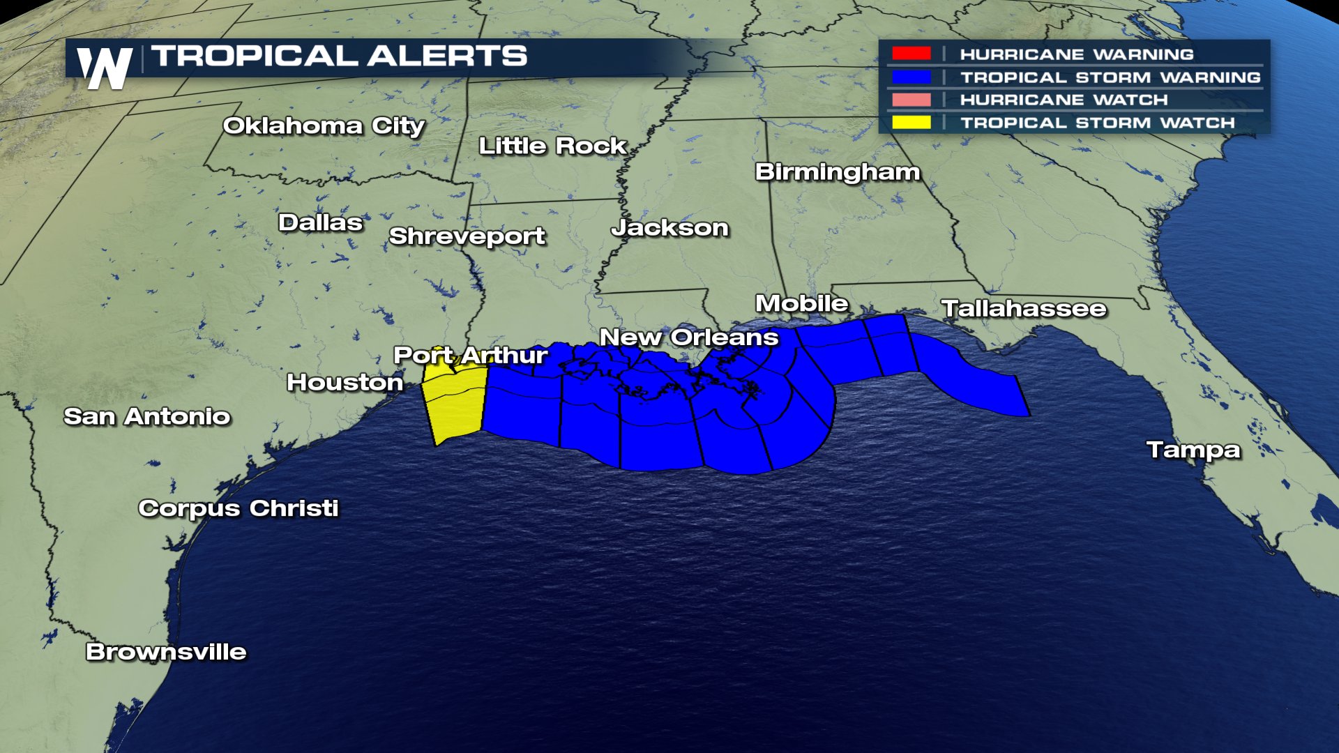
A Tropical Storm Warning is in effect for...
* San Luis Pass Texas to the Alabama-Florida border
* Metropolitan New Orleans
* Lake Pontchartrain
A Tropical Storm Warning means that tropical storm conditions are
expected somewhere within the warning area, in this case within the
next 12 to 24 hours.
Interests elsewhere along the U.S. Gulf Coast from the central Texas
coast to the western Florida Panhandle should monitor the progress
of this system.
For storm information specific to your area, including possible
inland watches and warnings, please monitor products issued by your
local National Weather Service forecast office.
DISCUSSION AND 48-HOUR OUTLOOK
------------------------------
At 700 AM CDT (1200 UTC), the center of Tropical Storm Cindy was
located near latitude 27.5 North, longitude 92.2 West. Cindy is
moving toward the northwest near 8 mph (13 km/h), and this motion is
expected to continue today. A turn toward the north-northwest and
then toward the north is expected later today and early Thursday. On
the forecast track, the center of Cindy will approach the coast of
southwest Louisiana and southeast Texas late today or tonight, and
move inland over southeastern Texas or southwestern Louisiana on
Thursday.
Maximum sustained winds remain near 60 mph (95 km/h) with higher
gusts. Little change in strength is expected today. Slight
weakening is forecast to begin on Thursday.
Tropical-storm-force winds extend outward up to 275 miles (445 km),
mainly north through northeast of the center.
The minimum central pressure recently reported by an Air Force
Hurricane Hunter aircraft was 996 mb (29.41 inches).
HAZARDS AFFECTING LAND
----------------------
RAINFALL: Cindy is expected to produce total rain accumulations of
6 to 9 inches with isolated maximum amounts of 12 inches over
southeastern Louisiana, southern Mississippi, southern Alabama, and
the Florida Panhandle through Thursday. This rainfall could cause
life-threatening flash flooding in these areas.
Rainfall amounts of 3 to 5 inches with isolated maximum amounts of 6
inches can be expected farther west across western Louisiana and
eastern Texas through Thursday. Rainfall should spread
northeastward across Arkansas and into portions of the Tennessee and
Ohio Valleys through Friday, with total rain accumulations of 3 to 5
inches with locally higher amounts possible.
WIND: Tropical storm conditions are affecting portions of the
northern Gulf of Mexico coast over the eastern part of the warning
area. These conditions should spread westward within the warning
area through early Thursday.
STORM SURGE: Inundation of 1 to 3 feet above ground level is
expected along the coast in portions of the Tropical Storm Warning
area, with isolated areas possibly up to 4 feet.
TORNADOES: A few tornadoes are possible this morning through
tonight from the western Florida Panhandle to southern Louisiana.
NEXT ADVISORY
-------------
Next complete advisory at 1000 AM CDT.
$$
Forecaster Avila
JRnOldsmar- Posts : 828
Reputation : 48
Join date : 2017-03-05
Location : Oldsmar, FL
Re: CLOSED Florida weather and Tropical season weather
![]() by LargoFL Wed Jun 21, 2017 8:20 am
by LargoFL Wed Jun 21, 2017 8:20 am

LargoFL- Posts : 10724
Reputation : 130
Join date : 2017-03-05
Re: CLOSED Florida weather and Tropical season weather
![]() by LargoFL Wed Jun 21, 2017 8:52 am
by LargoFL Wed Jun 21, 2017 8:52 am
LargoFL- Posts : 10724
Reputation : 130
Join date : 2017-03-05
Re: CLOSED Florida weather and Tropical season weather
![]() by LargoFL Wed Jun 21, 2017 8:58 am
by LargoFL Wed Jun 21, 2017 8:58 am
High: 101 °F...funny thing about over there...daytime its 100 or over degree's...then at night is down in the 50's lol..but my daughter says the humidity isn't like it is in Florida,so maybe 101 isn't so bad huh?..anyone have family out west?
LargoFL- Posts : 10724
Reputation : 130
Join date : 2017-03-05
Re: CLOSED Florida weather and Tropical season weather
![]() by gomexwx Wed Jun 21, 2017 9:02 am
by gomexwx Wed Jun 21, 2017 9:02 am
Temp:72
Humidity 97%
dew point :71
Barometer 29.87 digital,29.83 analog
winds ESE at 15mph
24 hr rain 5.51...
Forecast: more rain!

gomexwx- Posts : 641
Reputation : 63
Join date : 2012-07-16
Location : On an Acre somewhere on the gulf Coast
Re: CLOSED Florida weather and Tropical season weather
![]() by LargoFL Wed Jun 21, 2017 9:59 am
by LargoFL Wed Jun 21, 2017 9:59 am
good luck Gome,probably a lot more to come huh..hope no flooding by you there.gomexwx wrote:5.5 inches of rain so far from Cindy,it's still raining.
Temp:72
Humidity 97%
dew point :71
Barometer 29.87 digital,29.83 analog
winds ESE at 15mph
24 hr rain 5.51...
Forecast: more rain!
LargoFL- Posts : 10724
Reputation : 130
Join date : 2017-03-05
Re: CLOSED Florida weather and Tropical season weather
![]() by LargoFL Wed Jun 21, 2017 9:59 am
by LargoFL Wed Jun 21, 2017 9:59 am
LargoFL- Posts : 10724
Reputation : 130
Join date : 2017-03-05
Re: CLOSED Florida weather and Tropical season weather
![]() by JRnOldsmar Wed Jun 21, 2017 11:22 am
by JRnOldsmar Wed Jun 21, 2017 11:22 am
WTNT43 KNHC 211447
TCDAT3
Tropical Storm Cindy Discussion Number 8
NWS National Hurricane Center Miami FL AL032017
1000 AM CDT Wed Jun 21 2017
Cindy has the overall appearance of a subtropical cyclone this
morning with a convective cluster just northwest of the center and
additional convection in a ragged band well removed from the center
in the eastern semicircle. However, there is more convection near
the center than earlier, so the system remains a tropical cyclone on
this advisory. Regular water vapor imagery and experimental
low-level water vapor imagery from GOES-16 show that a significant
amount of dry air is present just east of the center, and this is
likely disrupting the convective organization. Surface observations
and reports from an Air Force Reserve Hurricane Hunter aircraft show
that the maximum winds have decreased a little and are now near 45
kt. The data also show that the 34-kt wind radii have decreased
over the northeastern quadrant.
The initial motion is now 310/9. There is little change in either
the track forecast philosophy or the track forecast from the
previous advisory. Cindy is expected to turn northward and move
through a break in the mid-level subtropical ridge along the
northwest Gulf of Mexico coast. Later in the forecast period Cindy,
or its remnants, should accelerate northeastward in the westerlies
over the eastern United States.
Given the presence of the dry air near the center and its affects
on the convection, little change in strength is expected before
landfall. Cindy should weaken after landfall and eventually become
absorbed in a frontal system over the eastern United States just
after 72 h.
While the aforementioned dry air is sufficient to keep Cindy from
intensifying, it will do little to reduce the overall rainfall
threat. Heavy rainfall is expected to continue over portions of the
central and eastern Gulf Coast, which could cause life-threatening
flash flooding in some locations. For more information on the
flooding hazard, see products from your local National Weather
Service office and the Weather Prediction Center.
FORECAST POSITIONS AND MAX WINDS
INIT 21/1500Z 27.6N 92.6W 45 KT 50 MPH
12H 22/0000Z 28.5N 93.4W 45 KT 50 MPH
24H 22/1200Z 30.3N 93.8W 40 KT 45 MPH...INLAND
36H 23/0000Z 32.3N 93.5W 30 KT 35 MPH...INLAND
48H 23/1200Z 34.3N 91.3W 25 KT 30 MPH...INLAND
72H 24/1200Z 37.0N 81.5W 20 KT 25 MPH...POST-TROP/EXTRATROP
96H 25/1200Z...DISSIPATED
$$
Forecaster Beven
JRnOldsmar- Posts : 828
Reputation : 48
Join date : 2017-03-05
Location : Oldsmar, FL
Page 4 of 9 • 1, 2, 3, 4, 5, 6, 7, 8, 9 ![]()
» CLOSED Florida/Alabama weather and Tropical weather affecting our states
» CLOSED Beginning of 2018 Tropical Season for Florida
» CLOSED Tropical Season heats up for Florida/Alabama
» CLOSED Florida/Alabama Fall Season weather
:: Florida Blog


» summer 2019 hurricane season
» April-May Florida weather and local events etc
» NASCAR 2019
» Late January through February outlook
» FLORIDA/ALABAMA AND THE HOLIDAY SEASON WEATHER
» NASCAR 2018
» CLOSED Florida/Alabama Blog - October Tropical Mischief