


One after another and another:
Page 2 of 4 •  1, 2, 3, 4
 ![]()
Re: One after another and another:
![]() by emcf30 Fri Feb 08, 2013 10:23 pm
by emcf30 Fri Feb 08, 2013 10:23 pm

emcf30- Posts : 975
Reputation : 10
Join date : 2012-07-16
Age : 93
Re: One after another and another:
![]() by emcf30 Fri Feb 08, 2013 10:24 pm
by emcf30 Fri Feb 08, 2013 10:24 pm
emcf30- Posts : 975
Reputation : 10
Join date : 2012-07-16
Age : 93
Re: One after another and another:
![]() by emcf30 Fri Feb 08, 2013 10:25 pm
by emcf30 Fri Feb 08, 2013 10:25 pm
emcf30- Posts : 975
Reputation : 10
Join date : 2012-07-16
Age : 93
Re: One after another and another:
![]() by emcf30 Fri Feb 08, 2013 10:26 pm
by emcf30 Fri Feb 08, 2013 10:26 pm
emcf30- Posts : 975
Reputation : 10
Join date : 2012-07-16
Age : 93
Re: One after another and another:
![]() by emcf30 Fri Feb 08, 2013 10:28 pm
by emcf30 Fri Feb 08, 2013 10:28 pm
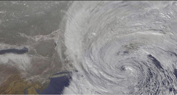
http://cimss.ssec.wisc.edu/goes/blog/wp-content/uploads/2013/02/130208_g13_wv_east_coast_storm_anim.gif
very large, takes a few to load
emcf30- Posts : 975
Reputation : 10
Join date : 2012-07-16
Age : 93
Re: One after another and another:
![]() by emcf30 Fri Feb 08, 2013 10:37 pm
by emcf30 Fri Feb 08, 2013 10:37 pm
emcf30- Posts : 975
Reputation : 10
Join date : 2012-07-16
Age : 93
Re: One after another and another:
![]() by emcf30 Fri Feb 08, 2013 10:38 pm
by emcf30 Fri Feb 08, 2013 10:38 pm
emcf30- Posts : 975
Reputation : 10
Join date : 2012-07-16
Age : 93
emcf30- Posts : 975
Reputation : 10
Join date : 2012-07-16
Age : 93

emcf30- Posts : 975
Reputation : 10
Join date : 2012-07-16
Age : 93
emcf30- Posts : 975
Reputation : 10
Join date : 2012-07-16
Age : 93
Re: One after another and another:
![]() by emcf30 Fri Feb 08, 2013 10:45 pm
by emcf30 Fri Feb 08, 2013 10:45 pm
emcf30- Posts : 975
Reputation : 10
Join date : 2012-07-16
Age : 93
Re: One after another and another:
![]() by emcf30 Fri Feb 08, 2013 10:52 pm
by emcf30 Fri Feb 08, 2013 10:52 pm

The mean average is the dark like and is steady at 30 inches now. Up from 24 inches last run. LOL, what did I tell you. We still will have to wait and see if it verifies.
emcf30- Posts : 975
Reputation : 10
Join date : 2012-07-16
Age : 93
Re: One after another and another:
![]() by emcf30 Fri Feb 08, 2013 10:55 pm
by emcf30 Fri Feb 08, 2013 10:55 pm
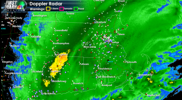
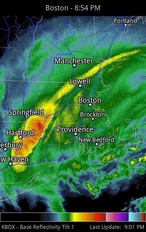
76 mph gust just reported at Boston's Logan Airport.
NWS upped the potential total for downtown Boston. Up to 31" for tonight and tomorrow combined
emcf30- Posts : 975
Reputation : 10
Join date : 2012-07-16
Age : 93
Re: One after another and another:
![]() by emcf30 Fri Feb 08, 2013 11:03 pm
by emcf30 Fri Feb 08, 2013 11:03 pm
emcf30- Posts : 975
Reputation : 10
Join date : 2012-07-16
Age : 93
Re: One after another and another:
![]() by emcf30 Fri Feb 08, 2013 11:30 pm
by emcf30 Fri Feb 08, 2013 11:30 pm
RGEM takes it slowly northeast to about 150 miles east of BOS by 12z with a wicked looking N-NE gradient over southern New England. Would expect gusts to 70-80 mph inland and 80-90 mph on the coast the way this is winding up (from NNE).
The deformation band would likely be extended northeast to run about 50 miles inland west of PWM to west of BOS by 06z and then would probably dissolve into the general banding of the storm later in the overnight. Some astronomical snowfall totals are possible, would not rule out 40-50 inch totals in some places close to this deformation band but also the storm is so wound up that some narrow dry slots are probably going to develop between bands. With the blowing and drifting this may not be very easy to measure by Sunday morning.
Last edited by emcf30 on Fri Feb 08, 2013 11:37 pm; edited 1 time in total
emcf30- Posts : 975
Reputation : 10
Join date : 2012-07-16
Age : 93
Re: One after another and another:
![]() by emcf30 Fri Feb 08, 2013 11:34 pm
by emcf30 Fri Feb 08, 2013 11:34 pm
http://www.erh.noaa.gov/hydromet/hydrometDisplay.php
emcf30- Posts : 975
Reputation : 10
Join date : 2012-07-16
Age : 93
emcf30- Posts : 975
Reputation : 10
Join date : 2012-07-16
Age : 93
Re: One after another and another:
![]() by sangria Sat Feb 09, 2013 6:15 am
by sangria Sat Feb 09, 2013 6:15 am
TWC in NYC is saying about 7.5" there.....(per the ruler...lol)
CT has several areas of over 30" totals, so far...


sangria- Admin
- Posts : 2345
Reputation : 55
Join date : 2012-07-16
sangria- Admin
- Posts : 2345
Reputation : 55
Join date : 2012-07-16
Re: One after another and another:
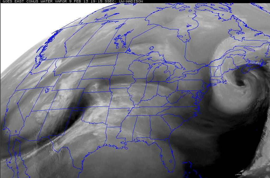
![]() by emcf30 Sat Feb 09, 2013 6:40 am
by emcf30 Sat Feb 09, 2013 6:40 am
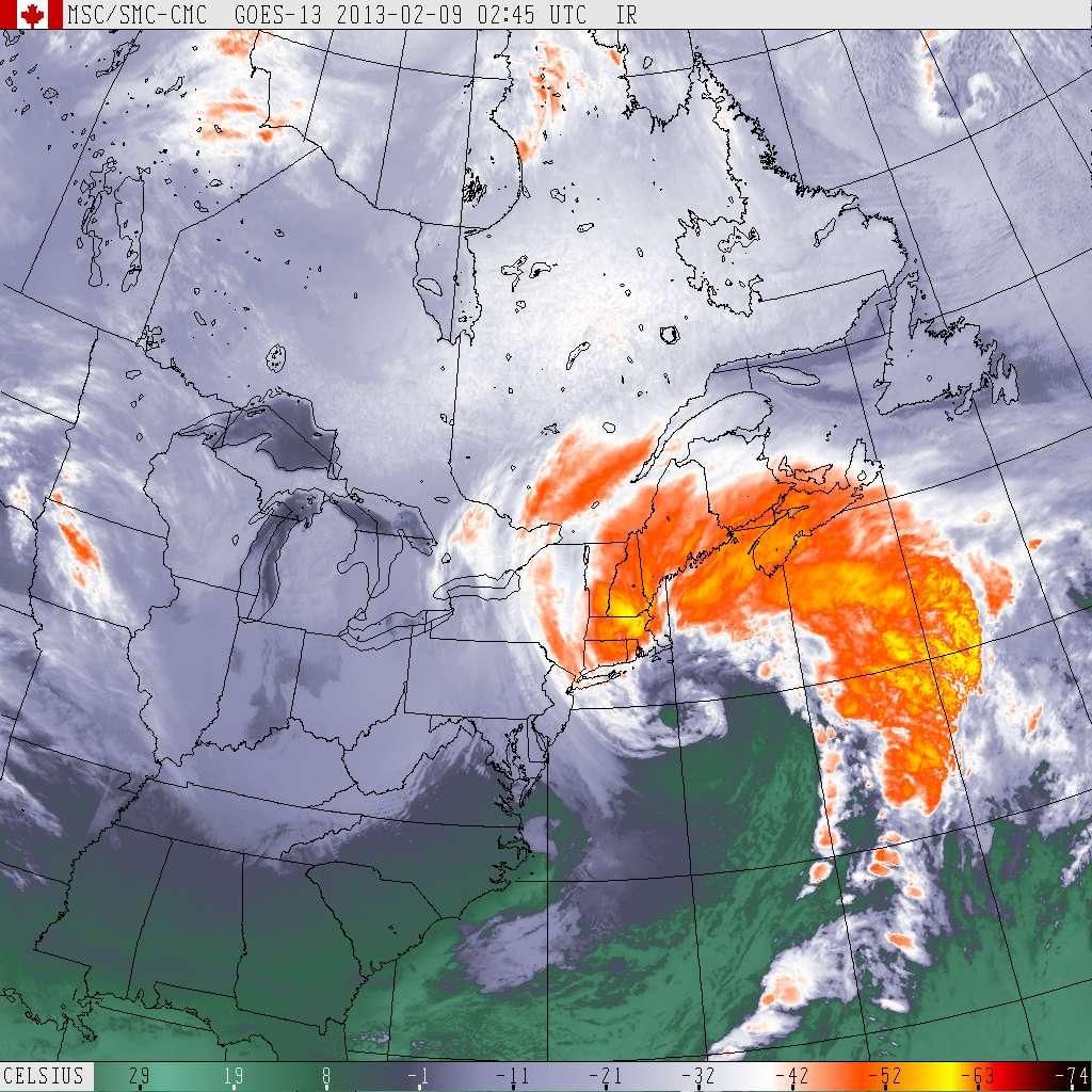
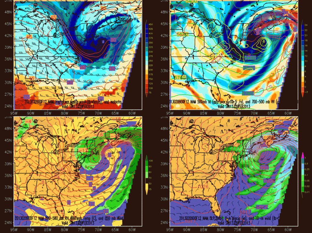
Dynamic tropopause on top left. Incredible northern stream phase interaction with the warm front. A lot of it is due to the odd upper level interactions...just don't see a setup like this very often. Note the rapidly forming PV strip over New England.
emcf30- Posts : 975
Reputation : 10
Join date : 2012-07-16
Age : 93
Re: One after another and another:
![]() by emcf30 Sat Feb 09, 2013 6:44 am
by emcf30 Sat Feb 09, 2013 6:44 am
emcf30- Posts : 975
Reputation : 10
Join date : 2012-07-16
Age : 93
Re: One after another and another:
![]() by sangria Sat Feb 09, 2013 6:47 am
by sangria Sat Feb 09, 2013 6:47 am
sangria- Admin
- Posts : 2345
Reputation : 55
Join date : 2012-07-16
Re: One after another and another:
![]() by emcf30 Sat Feb 09, 2013 6:47 am
by emcf30 Sat Feb 09, 2013 6:47 am

emcf30- Posts : 975
Reputation : 10
Join date : 2012-07-16
Age : 93
emcf30- Posts : 975
Reputation : 10
Join date : 2012-07-16
Age : 93
Re: One after another and another:
![]() by emcf30 Sat Feb 09, 2013 6:49 am
by emcf30 Sat Feb 09, 2013 6:49 am
emcf30- Posts : 975
Reputation : 10
Join date : 2012-07-16
Age : 93

emcf30- Posts : 975
Reputation : 10
Join date : 2012-07-16
Age : 93
Re: One after another and another:
![]() by sangria Sat Feb 09, 2013 7:43 am
by sangria Sat Feb 09, 2013 7:43 am
http://www.longislandexchange.com/traffic.php
Including the Long Island Expressway, with stranded motorists...

sangria- Admin
- Posts : 2345
Reputation : 55
Join date : 2012-07-16

gomexwx- Posts : 641
Reputation : 63
Join date : 2012-07-16
Location : On an Acre somewhere on the gulf Coast

StAugustineFL- Posts : 2231
Reputation : 64
Join date : 2012-07-17
emcf30- Posts : 975
Reputation : 10
Join date : 2012-07-16
Age : 93

emcf30- Posts : 975
Reputation : 10
Join date : 2012-07-16
Age : 93

emcf30- Posts : 975
Reputation : 10
Join date : 2012-07-16
Age : 93
emcf30- Posts : 975
Reputation : 10
Join date : 2012-07-16
Age : 93
emcf30- Posts : 975
Reputation : 10
Join date : 2012-07-16
Age : 93
Re: One after another and another:
![]() by emcf30 Sat Feb 09, 2013 3:19 pm
by emcf30 Sat Feb 09, 2013 3:19 pm
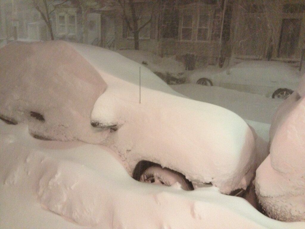
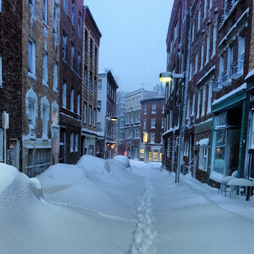
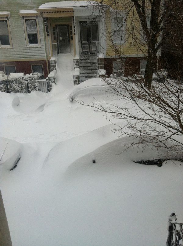
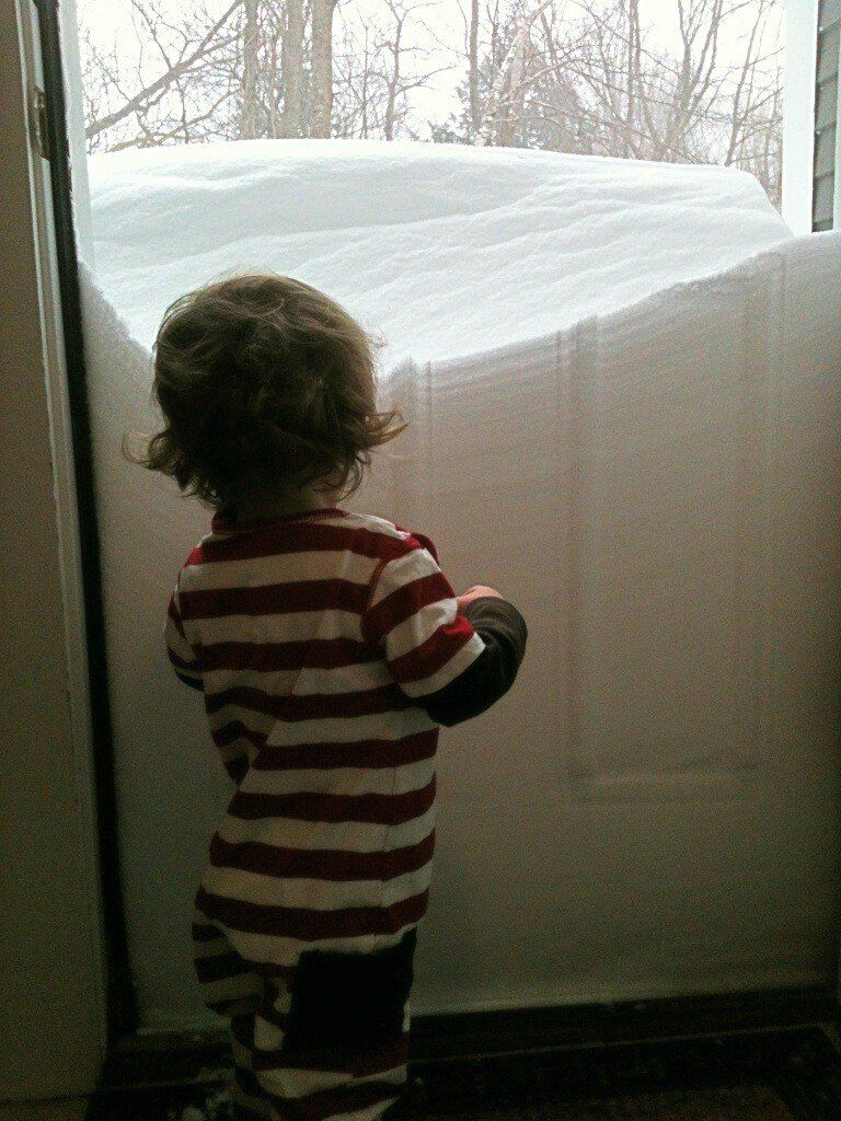
House on the coast. Road washed out by storm surge. House iced over from the blowing waves and mist.
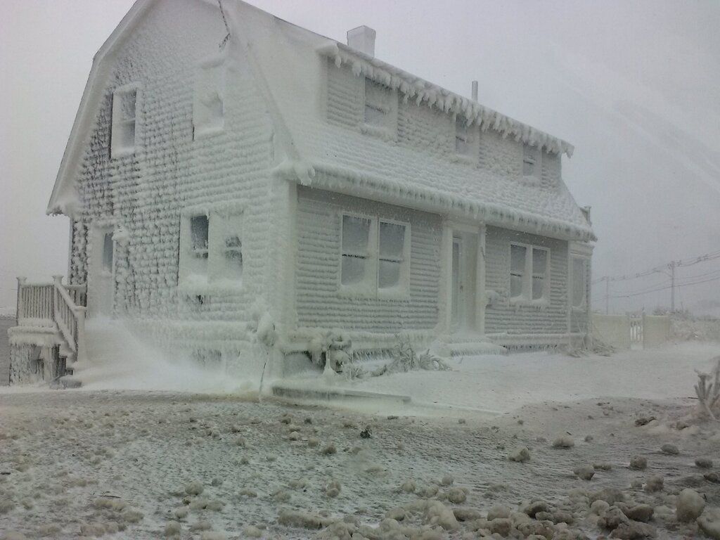
This is in Hull. Read it on the Internets so its got to be true.
emcf30- Posts : 975
Reputation : 10
Join date : 2012-07-16
Age : 93
Re: One after another and another:
![]() by emcf30 Sat Feb 09, 2013 3:21 pm
by emcf30 Sat Feb 09, 2013 3:21 pm
emcf30- Posts : 975
Reputation : 10
Join date : 2012-07-16
Age : 93
Re: One after another and another:
![]() by emcf30 Sat Feb 09, 2013 3:22 pm
by emcf30 Sat Feb 09, 2013 3:22 pm
Last edited by emcf30 on Sat Feb 09, 2013 3:26 pm; edited 1 time in total
emcf30- Posts : 975
Reputation : 10
Join date : 2012-07-16
Age : 93
emcf30- Posts : 975
Reputation : 10
Join date : 2012-07-16
Age : 93
Re: One after another and another:
![]() by sangria Sat Feb 09, 2013 5:28 pm
by sangria Sat Feb 09, 2013 5:28 pm
sangria- Admin
- Posts : 2345
Reputation : 55
Join date : 2012-07-16

StAugustineFL- Posts : 2231
Reputation : 64
Join date : 2012-07-17
Re: One after another and another:
![]() by StAugustineFL Sat Feb 09, 2013 9:47 pm
by StAugustineFL Sat Feb 09, 2013 9:47 pm
StAugustineFL- Posts : 2231
Reputation : 64
Join date : 2012-07-17
StAugustineFL- Posts : 2231
Reputation : 64
Join date : 2012-07-17
StAugustineFL- Posts : 2231
Reputation : 64
Join date : 2012-07-17
StAugustineFL- Posts : 2231
Reputation : 64
Join date : 2012-07-17
emcf30- Posts : 975
Reputation : 10
Join date : 2012-07-16
Age : 93
Re: One after another and another:
![]() by sangria Sun Feb 10, 2013 5:39 am
by sangria Sun Feb 10, 2013 5:39 am
warning has since expired, and watch is in place.......

http://www.spc.noaa.gov/products/watch/ww0029.html
animated loop - http://www.meteo.psu.edu/~fxg1/WXTYPE/loop25se.html
sangria- Admin
- Posts : 2345
Reputation : 55
Join date : 2012-07-16
Re: One after another and another:
![]() by sangria Sun Feb 10, 2013 5:48 am
by sangria Sun Feb 10, 2013 5:48 am
0752 150 2 W INKS LAKE STATE PAR LLANO TX 3072 9841 HAIL FELL FOR 11 MINUTES. LARGEST 1.5 INCHES. (EWX)
sangria- Admin
- Posts : 2345
Reputation : 55
Join date : 2012-07-16
Re: One after another and another:
![]() by sangria Sun Feb 10, 2013 6:00 am
by sangria Sun Feb 10, 2013 6:00 am
http://hisz.rsoe.hu/alertmap/index2.php?area=usa

sangria- Admin
- Posts : 2345
Reputation : 55
Join date : 2012-07-16
Re: One after another and another:
![]() by sangria Sun Feb 10, 2013 6:36 am
by sangria Sun Feb 10, 2013 6:36 am

MESOSCALE DISCUSSION 0135
NWS STORM PREDICTION CENTER NORMAN OK
0512 AM CST SUN FEB 10 2013
AREAS AFFECTED...CENTRAL/SOUTH-CENTRAL TX
CONCERNING...TORNADO WATCH 29...
VALID 101112Z - 101245Z
THE SEVERE WEATHER THREAT FOR TORNADO WATCH 29 CONTINUES.
SUMMARY...TORNADO WATCH 29 CONTINUES...WITH A CONTINUED TORNADO
POTENTIAL MAINLY ACROSS EAST-CENTRAL TX ASIDE FROM DAMAGING
WINDS/SOME HAIL.
DISCUSSION...SEVERAL SEMI-DISCRETE SUPERCELLS HAVE PERSISTED/MOVED
NORTHEASTWARD OVERNIGHT ACROSS CENTRAL TX...AND PRIMARY POTENTIAL
FOR A TORNADO/HAIL WILL PERSIST IN THE PREDAWN HOURS WITH THESE
STORMS IN THE PRESENCE OF STRONG SHEAR AND AN INCREASINGLY MOIST
LOW-LEVEL ENVIRONMENT. SUCH A THREAT MAY ESPECIALLY BE THE CASE IN
THE SHORT-TERM WITH A SUPERCELL CURRENTLY LOCATED 35-40 MILES EAST
OF TEMPLE TX NEAR THE FALLS/ROBERTSON COUNTY LINE AS OF 1110Z.
HOWEVER...THESE SEMI-DISCRETE TSTMS WILL CONTINUE TO BE OVERTAKEN
BY/MERGE WITH THE SQUALL LINE NOW CROSSING NORTHEAST/CENTRAL TX
THROUGH 12Z-14Z...WITH DAMAGING WINDS AS THE PRIMARY CONCERN.
FARTHER SOUTH INTO SOUTH-CENTRAL TX...TSTM COVERAGE/VIGOR MAY REMAIN
TEMPERED BY A RESIDUAL ELEVATED MIXED LAYER AND NEUTRAL MID-UPPER
FORCING FOR ASCENT. FARTHER EAST/LATER THIS MORNING...MORE OF A
TORNADO THREAT COULD MATERIALIZE ACROSS EAST TX INTO LA...SUCH THAT
A NEW WATCH/TORNADO WATCH UPGRADE COULD BE NEEDED.
..GUYER.. 02/10/2013
sangria- Admin
- Posts : 2345
Reputation : 55
Join date : 2012-07-16
Re: One after another and another:
![]() by sangria Sun Feb 10, 2013 8:23 am
by sangria Sun Feb 10, 2013 8:23 am

URGENT - IMMEDIATE BROADCAST REQUESTED
TORNADO WATCH NUMBER 31
NWS STORM PREDICTION CENTER NORMAN OK
700 AM CST SUN FEB 10 2013
THE NWS STORM PREDICTION CENTER HAS ISSUED A
TORNADO WATCH FOR PORTIONS OF
SOUTHEAST ARKANSAS
WESTERN...CENTRAL...AND NORTHERN LOUISIANA
EAST TEXAS
EFFECTIVE THIS SUNDAY MORNING AND AFTERNOON FROM 700 AM UNTIL 200
PM CST.
TORNADOES...HAIL TO 1.5 INCHES IN DIAMETER...THUNDERSTORM WIND
GUSTS TO 75 MPH...AND DANGEROUS LIGHTNING ARE POSSIBLE IN THESE
AREAS.
THE TORNADO WATCH AREA IS APPROXIMATELY ALONG AND 105 STATUTE
MILES EAST AND WEST OF A LINE FROM 60 MILES NORTH NORTHEAST OF
MONROE LOUISIANA TO 55 MILES SOUTH SOUTHEAST OF LUFKIN TEXAS.
FOR A COMPLETE DEPICTION OF THE WATCH SEE THE ASSOCIATED WATCH
OUTLINE UPDATE (WOUS64 KWNS WOU1).
REMEMBER...A TORNADO WATCH MEANS CONDITIONS ARE FAVORABLE FOR
TORNADOES AND SEVERE THUNDERSTORMS IN AND CLOSE TO THE WATCH
AREA. PERSONS IN THESE AREAS SHOULD BE ON THE LOOKOUT FOR
THREATENING WEATHER CONDITIONS AND LISTEN FOR LATER STATEMENTS
AND POSSIBLE WARNINGS.
OTHER WATCH INFORMATION...CONTINUE...WW 29...WW 30...
DISCUSSION...LOOSELY-ORGANIZED E TX SQLN LINE WITH EMBEDDED
SUPERCELLS EXPECTED TO CONTINUE GENERALLY ESEWD...WHILE STORMS
WITHIN THE LINE MOVE MORE RAPIDLY NEWD ALONG IT. THE LOW-LVL WLY
FLOW IN THE WAKE OF THE SQLN SHOULD CONTINUE TO SLOWLY WEAKEN.
THIS...COUPLED WITH EXISTING STRENGTH OF DEEP SWLY SHEAR /AOA 60
KTS/ AND THE CONTINUED NWD SPREAD OF RICH LOW-LVL MOISTURE INTO FAR
E TX/LA... SUGGESTS THAT STORMS WITHIN THE LINE MAY REMAIN
SEMI-DISCRETE...ENHANCING THE RISK FOR OCCASIONAL TORNADOES IN
ADDITION TO DMGG WIND/MARGINALLY SVR HAIL. SOME RISK ALSO WILL EXIST
FOR THE DEVELOPMENT OF A FEW SUPERCELLS AHEAD OF THE SQLN LINE NEAR
THE SABINE RVR EWD INTO CNTRL LA AS SFC HEATING FURTHER DESTABILIZES
REGION/OVERCOMES EML CAP INVOF DIFFUSE WARM FRONT.
AVIATION...TORNADOES AND A FEW SEVERE THUNDERSTORMS WITH HAIL
SURFACE AND ALOFT TO 1.5 INCHES. EXTREME TURBULENCE AND SURFACE
WIND GUSTS TO 65 KNOTS. A FEW CUMULONIMBI WITH MAXIMUM TOPS TO
400. MEAN STORM MOTION VECTOR 25040.
sangria- Admin
- Posts : 2345
Reputation : 55
Join date : 2012-07-16
Page 2 of 4 • 1, 2, 3, 4 ![]()


» summer 2019 hurricane season
» April-May Florida weather and local events etc
» NASCAR 2019
» Late January through February outlook
» FLORIDA/ALABAMA AND THE HOLIDAY SEASON WEATHER
» NASCAR 2018
» CLOSED Florida/Alabama Blog - October Tropical Mischief