Latest topics
Warnings
Most Viewed Topics
Search
Fantasy Storm or not!
4 posters
Page 1 of 1
 Fantasy Storm or not!
Well it appears Winter does not want to give up. There is still opportunity for some decent snow events and even another Nor-Easter or two to develop and affect the East Coast.
Lets start with the current situation:
Heavy snow from a developing storm is moving across the northern Plains and upper Midwest today. On Monday, to will continue to move East before targeting the Northeast once again.
Current precipitation.


As has been the case a Winter, this little system will be setting the the Atmosphere for a possible series of larger events to unfold later on this week. Cold airs will be moving South out of Canada taking a firm hold on much of the Northern States. For instance in Minneapolis, Last year on St Patrick's Day it was 80 degrees. This year, the high will be in the 20's. The reason for this cold burst is because the upper level patterns are going to be at the mercy two separate positive heights anomalies with one being directly over the North Pole and the other in the far North Atlantic. These features will merge or phase together later this week. This WILL create a deep Negative AO pattern which most always equals much colder temperatures across the CONUS. There will be high latitude blocking setting up along the Central and Eastern US At the Mid Levels, there will be a conveyor belt of amplified waves moving across the country.
The most interesting system could unfold on Friday and Saturday. But as usual, the Euro and the GFS sees it differently. From the NWS.
THE MOST CHANGEABLE PART OF THE FORECAST REMAINS FRI-SAT/D6-7. THE
ECMWF AND ITS MEAN HAVE SHOWED A MUCH MORE SUPPRESSED SYSTEM
MOVING OUT OF THE ROCKIES AND THRU THE SRN PLAINS TO THE SERN US
COMPARED TO RECENT GFS/CMC RUNS. GEFS/CMC/NAEFS MEANS FALL
SOMEWHAT IN BETWEEN BUT HAVE TRENDED TOWARD SUPPRESSION IN RECENT
RUNS. EVEN SO...THE GFS AND CMC HAS SHIFTED SOME FOCUS FOR LOW
PRESSURE THRU THE SRN/SERN US RATHER THAN THE MIDWEST/OH VALLEY
AND THAT TREND SEEMS REASONABLE CONSIDERING THE UPPER LOW OVER
QUEBEC SHOULD SUPPORT FORCING ENERGIES EWD RATHER THAN NEWD.
INCORPORATING SOME WEIGHTING TO THE GFS/GEFS/CMC IN THE WPC BLEND
LEFT MORE ROOM FOR ME TO INCLUDE A MORE ORGANIZED LOW TRACK THAN
THE EC/EC ENSEMBLES ACROSS THE SRN/SERN US TIER IN POSITION
CONSISTENT WITH A DECENT CLUSTER OF GFS/CMC/EC ENSEMBLE MEMBERS.
The GFS has the low starting to bomb out and crushes VA and N NC. with some fantasy snow .


The Euro has a narrow band of snow and freezing rain moving across the Deep South .


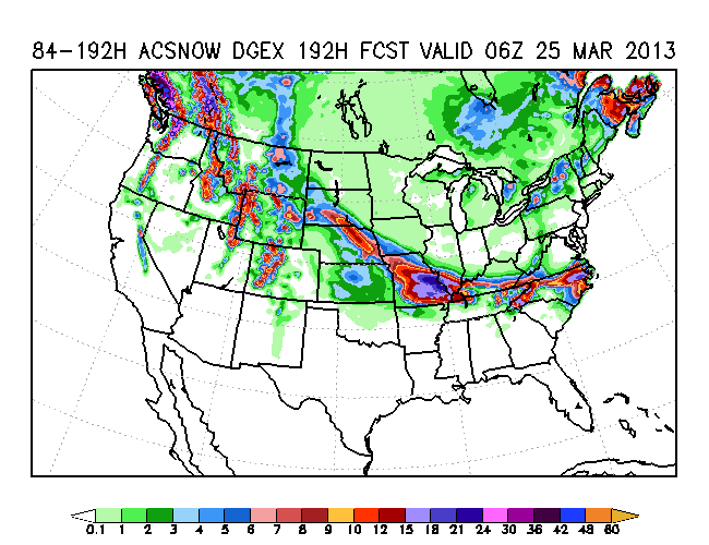
00z Euro with a 983 mb low off of Hatteras and one hell of a trough in the East for this time of the year. 850 0 degree temps down to the gulf.
This is from NWS Huntsville.
THIS WILL BE ACCOMPANIED BY A SURFACE LOW
PUSHING SOUTHEASTWARD THROUGH CENTRAL TEXAS ON THURSDAY AND SPREADING
RAPIDLY EASTWARD ALONG THE GULF COAST THURSDAY NIGHT/FRIDAY.
WIDESPREAD PRECIPITATION WILL DEVELOP TO THE NORTH OF THE SURFACE LOW
-- WHICH WILL LIKELY IMPACT THE REGION ON THURSDAY NIGHT AND FRIDAY.
IT IS QUITE POSSIBLE THAT THIS COULD END UP BEING A HIGH-IMPACT
WINTER PRECIPITATION EVENT FOR AT LEAST A PORTION OF THE FORECAST
AREA -- LIKELY CONSISTING OF SNOW AND SLEET...SOME OF WHICH COULD BE
QUITE HEAVY. IT IS TOO EARLY TO MENTION WINTRY PRECIP AT THIS
TIME...BUT IF TRENDS CONTINUE THEN THIS THREAT WILL LIKELY NEED TO BE
ADDED SOON.
If anything, it will be something new to watch
Lets start with the current situation:
Heavy snow from a developing storm is moving across the northern Plains and upper Midwest today. On Monday, to will continue to move East before targeting the Northeast once again.
Current precipitation.


As has been the case a Winter, this little system will be setting the the Atmosphere for a possible series of larger events to unfold later on this week. Cold airs will be moving South out of Canada taking a firm hold on much of the Northern States. For instance in Minneapolis, Last year on St Patrick's Day it was 80 degrees. This year, the high will be in the 20's. The reason for this cold burst is because the upper level patterns are going to be at the mercy two separate positive heights anomalies with one being directly over the North Pole and the other in the far North Atlantic. These features will merge or phase together later this week. This WILL create a deep Negative AO pattern which most always equals much colder temperatures across the CONUS. There will be high latitude blocking setting up along the Central and Eastern US At the Mid Levels, there will be a conveyor belt of amplified waves moving across the country.
The most interesting system could unfold on Friday and Saturday. But as usual, the Euro and the GFS sees it differently. From the NWS.
THE MOST CHANGEABLE PART OF THE FORECAST REMAINS FRI-SAT/D6-7. THE
ECMWF AND ITS MEAN HAVE SHOWED A MUCH MORE SUPPRESSED SYSTEM
MOVING OUT OF THE ROCKIES AND THRU THE SRN PLAINS TO THE SERN US
COMPARED TO RECENT GFS/CMC RUNS. GEFS/CMC/NAEFS MEANS FALL
SOMEWHAT IN BETWEEN BUT HAVE TRENDED TOWARD SUPPRESSION IN RECENT
RUNS. EVEN SO...THE GFS AND CMC HAS SHIFTED SOME FOCUS FOR LOW
PRESSURE THRU THE SRN/SERN US RATHER THAN THE MIDWEST/OH VALLEY
AND THAT TREND SEEMS REASONABLE CONSIDERING THE UPPER LOW OVER
QUEBEC SHOULD SUPPORT FORCING ENERGIES EWD RATHER THAN NEWD.
INCORPORATING SOME WEIGHTING TO THE GFS/GEFS/CMC IN THE WPC BLEND
LEFT MORE ROOM FOR ME TO INCLUDE A MORE ORGANIZED LOW TRACK THAN
THE EC/EC ENSEMBLES ACROSS THE SRN/SERN US TIER IN POSITION
CONSISTENT WITH A DECENT CLUSTER OF GFS/CMC/EC ENSEMBLE MEMBERS.
THE MOST CHANGEABLE PART OF THE FORECAST REMAINS FRI-SAT/D6-7. THE
ECMWF AND ITS MEAN HAVE SHOWED A MUCH MORE SUPPRESSED SYSTEM
MOVING OUT OF THE ROCKIES AND THRU THE SRN PLAINS TO THE SERN US
COMPARED TO RECENT GFS/CMC RUNS. GEFS/CMC/NAEFS MEANS FALL
SOMEWHAT IN BETWEEN BUT HAVE TRENDED TOWARD SUPPRESSION IN RECENT
RUNS. EVEN SO...THE GFS AND CMC HAS SHIFTED SOME FOCUS FOR LOW
PRESSURE THRU THE SRN/SERN US RATHER THAN THE MIDWEST/OH VALLEY
AND THAT TREND SEEMS REASONABLE CONSIDERING THE UPPER LOW OVER
QUEBEC SHOULD SUPPORT FORCING ENERGIES EWD RATHER THAN NEWD.
INCORPORATING SOME WEIGHTING TO THE GFS/GEFS/CMC IN THE WPC BLEND
LEFT MORE ROOM FOR ME TO INCLUDE A MORE ORGANIZED LOW TRACK THAN
THE EC/EC ENSEMBLES ACROSS THE SRN/SERN US TIER IN POSITION
CONSISTENT WITH A DECENT CLUSTER OF GFS/CMC/EC ENSEMBLE MEMBERS.
The GFS has the low starting to bomb out and crushes VA and N NC. with some fantasy snow .


The Euro has a narrow band of snow and freezing rain moving across the Deep South .


00z Euro with a 983 mb low off of Hatteras and one hell of a trough in the East for this time of the year. 850 0 degree temps down to the gulf.
This is from NWS Huntsville.
THIS WILL BE ACCOMPANIED BY A SURFACE LOW
PUSHING SOUTHEASTWARD THROUGH CENTRAL TEXAS ON THURSDAY AND SPREADING
RAPIDLY EASTWARD ALONG THE GULF COAST THURSDAY NIGHT/FRIDAY.
WIDESPREAD PRECIPITATION WILL DEVELOP TO THE NORTH OF THE SURFACE LOW
-- WHICH WILL LIKELY IMPACT THE REGION ON THURSDAY NIGHT AND FRIDAY.
IT IS QUITE POSSIBLE THAT THIS COULD END UP BEING A HIGH-IMPACT
WINTER PRECIPITATION EVENT FOR AT LEAST A PORTION OF THE FORECAST
AREA -- LIKELY CONSISTING OF SNOW AND SLEET...SOME OF WHICH COULD BE
QUITE HEAVY. IT IS TOO EARLY TO MENTION WINTRY PRECIP AT THIS
TIME...BUT IF TRENDS CONTINUE THEN THIS THREAT WILL LIKELY NEED TO BE
ADDED SOON.
If anything, it will be something new to watch

emcf30- Posts : 975
Reputation : 10
Join date : 2012-07-16
Age : 93
 Re: Fantasy Storm or not!
Thanks for the new blog E. Finally something to watch after a boring last week.

StAugustineFL- Posts : 2231
Reputation : 64
Join date : 2012-07-17
 Re: Fantasy Storm or not!
LOL at the GFS storm.....that truly would be a "fantasy" storm, for the folks over in NC......the kids would be having a ball, if it happened!!!

sangria- Admin
- Posts : 2345
Reputation : 55
Join date : 2012-07-16
 Re: Fantasy Storm or not!
From Last Night. Beautiful.


emcf30- Posts : 975
Reputation : 10
Join date : 2012-07-16
Age : 93
 Re: Fantasy Storm or not!
Cool pic of the northern lights.

StAugustineFL- Posts : 2231
Reputation : 64
Join date : 2012-07-17
 Re: Fantasy Storm or not!
FORECAST SPREAD/UNCERTAINTY AND RUN-RUN CONTINUITY
INCREASES SIGNIFICANTLY HEADING INTO NEXT WEEKEND. THE MOST
PROMINANT GUIDANCE DIFFERENCE ALOFT CONCERNS THE DIGGING AND EWD
EJECTION OF ENERGY OUT FROM THE WRN US THEN S-CENTRAL AND SERN US
FRI-SUN...ALONG WITH THE ASSOCIATED LOWER ATMOSPHERIC RESPONSE.
RECENT ECMWF/ECMWF ENSEMBLES IN PARTICULAR HAVE OFFERED MORE
SUPPRESSED SOLUTIONS THAN RECENT GFS/GEFS. DIFFERENCES ALOFT
BECOME CRYSTAL CLEAR BY NEXT SUN...ALBEIT WITHOUT GOOD RUN-RUN
CONTINUITY. THE 00 UTC ECMWF HAS AN AMPLIFIED TROUGH OVER THE SW
US WHILE THE 00/06 UTC GFS RUNS INSTEAD OFFER A DEEP SERN
US/MID-ATLC COASTAL STORM. ENSEMBLES ARE MIXED/IN THE MIDDLE BUT
OVERALL FAVOR A SOLUTION WITH EMPHASIS OVER THE SRN/SERN US. THIS
SEEMS VERY REASONABLE AS INITIALLY VIGOROUS SYSTEMS LIKE THIS ONE
TRACKING RATHER BODILY INLAND FROM THE PACIFIC ARE MORE LIKELY TO
MAINTAIN GOOD STREAM IDENTITY WITH A BETTER THAN AVERAGE LINEAR
MOTION DOWNSTREAM.
LATEST WPC PROGS FRI-SUN/D5-7 WERE PRIMARILY DERIVED FROM A BLEND
OF THE 00 UTC GEFS ENSEMBLE MEAN AND LESS DEFINED 00 UTC ECMWF
ENSEMBLE MEAN. WPC PROGS WERE THEN MANUALLY ADJUSTED TO DEPICT
SLIGHTLY BETTER SYSTEM ORGANIZATION CONSISTENT WITH UNCERTAINTY
AND A LESS SUPPRESSED SERN US SOLUTION THAN OVERNIGHT PROGS GIVEN
AMPLITUDE ALOFT/DYNAMIC POTENTIAL. A WSR FLIGHT LATER TODAY OUT
FROM HAWAII MAY BE ABLE TO PROVIDE MORE DATA FOR UPCOMING 00 UTC
GUIDANCE.
...SENSIBLE WEATHER HIGHLIGHTS...
A WET SYSTEM ENTERING THE PAC NW MIDWEEK WILL SPREAD
MODEST RAIN/SNOW AND SOME ENHANCED TERRAIN AMOUNTS THRU THE WEST
BEFORE SETTLING INTO THE S-CENTRAL US THEN GULF COAST FRI-SAT/D5-6
WHERE INCREASED MOISTURE INFLOW MAY LEAD TO HEAVIER
QPF...INCLUDING A POSSIBLE WINTER WEATHER STRIPE ON THE NRN EDGE
OF THE OVERALL PCPN SHIELD GIVEN THE COLD PATTERN. EMERGENCE FROM
THE SERN US BY SUN OFFERS POTENTIAL FOR COASTAL CYCLOGENSIS GIVEN
POSSIBLE DYNAMIC SUPPORT.

emcf30- Posts : 975
Reputation : 10
Join date : 2012-07-16
Age : 93
 Re: Fantasy Storm or not!
Winters last gasp....moderation being the key to how bad the storm is.

gomexwx- Posts : 641
Reputation : 63
Join date : 2012-07-16
Location : On an Acre somewhere on the gulf Coast
 Re: Fantasy Storm or not!
Aug's forecast for me, on Saturday.......gotta document it, somewhere!!!!!
[16:46:13 21/03/13] StAugustineFL : I'm predicting 82 for you and .47" of rain
[16:46:13 21/03/13] StAugustineFL : I'm predicting 82 for you and .47" of rain

sangria- Admin
- Posts : 2345
Reputation : 55
Join date : 2012-07-16
 Similar topics
» The Atlantic Express - Tropical Storm Isaac - Tropical STorm Joyce- and New AOI
» Tropical Storm Hermine UPDATE 9/1/16
» Tropical Storm Leslie - Can you say Irene........
» Tropical Storm Erika
» One after another and another:
» Tropical Storm Hermine UPDATE 9/1/16
» Tropical Storm Leslie - Can you say Irene........
» Tropical Storm Erika
» One after another and another:
Page 1 of 1
Permissions in this forum:
You cannot reply to topics in this forum






» summer 2019 hurricane season
» April-May Florida weather and local events etc
» NASCAR 2019
» Late January through February outlook
» FLORIDA/ALABAMA AND THE HOLIDAY SEASON WEATHER
» NASCAR 2018
» CLOSED Florida/Alabama Blog - October Tropical Mischief