Latest topics
Warnings
Most Viewed Topics
Search
Tropics Tonight
4 posters
Page 1 of 1
 Tropics Tonight
Seeing how Erika, got destroyed by shear from El Nino ,or in the case of this year "El NoNo", we can only talk about remnants and waves. So since we are concentrating on the Atlantic Basin,we will start in the Eastern Atlantic and work our way West.
First: Near latitude 10N and Longitude 20W we have a vigorous tropical wave exiting the African Continent
This could be the next named system. This area should move WNW for the next few days.

As we move to the Central Atlantic Near Latitude 10N,Longitude 30W we have a tropical wave. This wave does not have a lot of moisture to work with as there is an Saharan Air Layer keeping the atmosphere dry. There is also 30 kt shear in the area. I don't see any development of this wave for the next few days.
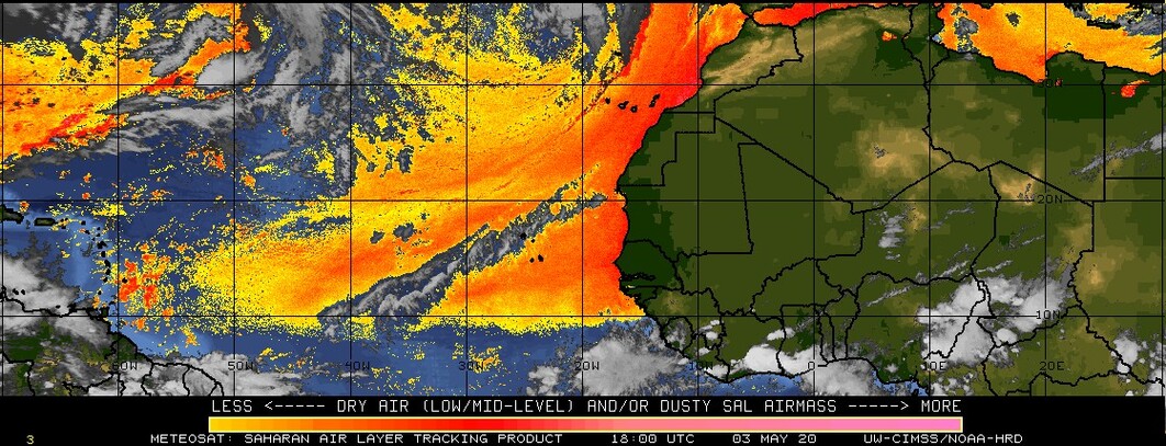
Both the system exiting Africa below the Cape Verde Islands, and this wave will have a hard time due to El Nino, creating shear and this Saharan Air Layer pictured below
Now we look farther West in the Central Atlantic and we see another disturbance near Latitude 12N ,Longitude 48W riding the ITCZ(Intertropical Convergence Zone) This disturbance is moving towards the West and has 20 to 20kt wind shear to contend with. I don't see any development for the next 24-36 hours if any.

Now lets look at the Caribbean first thing that "Grab's Ya" is the remnants and wave axis of the once Tropical Storm Erika, who was taken down by the Sword of El Nino. Could this get complicated? You Bet! North of Cuba we have a broad area of low pressure that once was associated with Erika's LLC. Then the wave that Erika was riding is firing Thunderstorms South of Cuba. What will happen with this mess? I believe The remnant low will move WNW thorogh the Florida straits into the Eastern Gulf of Mexico. This WNW movement will be because of the Bermuda high's attraction to the ULL over the Northern Gulf that's retrograding to the NNW. I believe after it reaches the Gulf you will see more of a NW to NNW movement. I give the remnant low a 31% chance of development. Wind Shear will have to drop quick as the ULL Moves NNW for this to really have a chance. As far as the Southern part of the wave in the Caribbean South of Cuba,it continues moving West and remains a tropical wave.

Next up is the Gulf of Mexico. The Gulf is dominated by an ULL (Upper Level Low) Nothing will develop there until the shear from that low subsides and that low moves off to the NNW
That is...The Tropics Tonight!
First: Near latitude 10N and Longitude 20W we have a vigorous tropical wave exiting the African Continent
This could be the next named system. This area should move WNW for the next few days.

As we move to the Central Atlantic Near Latitude 10N,Longitude 30W we have a tropical wave. This wave does not have a lot of moisture to work with as there is an Saharan Air Layer keeping the atmosphere dry. There is also 30 kt shear in the area. I don't see any development of this wave for the next few days.
Both the system exiting Africa below the Cape Verde Islands, and this wave will have a hard time due to El Nino, creating shear and this Saharan Air Layer pictured below

Now we look farther West in the Central Atlantic and we see another disturbance near Latitude 12N ,Longitude 48W riding the ITCZ(Intertropical Convergence Zone) This disturbance is moving towards the West and has 20 to 20kt wind shear to contend with. I don't see any development for the next 24-36 hours if any.

Now lets look at the Caribbean first thing that "Grab's Ya" is the remnants and wave axis of the once Tropical Storm Erika, who was taken down by the Sword of El Nino. Could this get complicated? You Bet! North of Cuba we have a broad area of low pressure that once was associated with Erika's LLC. Then the wave that Erika was riding is firing Thunderstorms South of Cuba. What will happen with this mess? I believe The remnant low will move WNW thorogh the Florida straits into the Eastern Gulf of Mexico. This WNW movement will be because of the Bermuda high's attraction to the ULL over the Northern Gulf that's retrograding to the NNW. I believe after it reaches the Gulf you will see more of a NW to NNW movement. I give the remnant low a 31% chance of development. Wind Shear will have to drop quick as the ULL Moves NNW for this to really have a chance. As far as the Southern part of the wave in the Caribbean South of Cuba,it continues moving West and remains a tropical wave.

Next up is the Gulf of Mexico. The Gulf is dominated by an ULL (Upper Level Low) Nothing will develop there until the shear from that low subsides and that low moves off to the NNW
That is...The Tropics Tonight!
Last edited by gomexwx on Sat Aug 29, 2015 6:42 pm; edited 1 time in total

gomexwx- Posts : 641
Reputation : 63
Join date : 2012-07-16
Location : On an Acre somewhere on the gulf Coast
 Re: Tropics Tonight
Second! The wave that exited Africa is now TS Fred. Looks like it'll be a fish.

StAugustineFL- Posts : 2231
Reputation : 64
Join date : 2012-07-17
 Re: Tropics Tonight
Dang...two blogs in one week. Where's my rain???!!!! 


sangria- Admin
- Posts : 2345
Reputation : 55
Join date : 2012-07-16
 Similar topics
» Tracking the Tropics
» Eyes on the Tropics and More Severe Weather
» TROUBLE IN THE TROPICS, Coming Soon to a Body of Water near you.....
» Eyes on the Tropics and More Severe Weather
» TROUBLE IN THE TROPICS, Coming Soon to a Body of Water near you.....
Page 1 of 1
Permissions in this forum:
You cannot reply to topics in this forum






» summer 2019 hurricane season
» April-May Florida weather and local events etc
» NASCAR 2019
» Late January through February outlook
» FLORIDA/ALABAMA AND THE HOLIDAY SEASON WEATHER
» NASCAR 2018
» CLOSED Florida/Alabama Blog - October Tropical Mischief