


Eyes on the Tropics and More Severe Weather

Eyes on the Tropics and More Severe Weather
![]() by emcf30 Fri Jul 27, 2012 8:35 am
by emcf30 Fri Jul 27, 2012 8:35 am
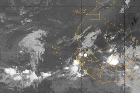
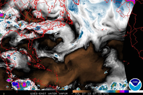
Since the system is farther south it is a bit more removed from dry air and dust that has inhibited development of the systems moving westward off of Africa thus far. The dust is still there. However, the amount of dust has lessened over the past few days.

The key to development is the eventual track this Tropical Wave takes. At some point this weekend the system may start to move North of it's present track. If the wave does not move to far the the North, the system has a chance at development.
Irregardless of development, this wave will bring periods of showers and thunderstorms to part of the Caribbean islands next week.
Early in the week, the system will be near the Lesser Antilles, but will then push toward the Greater Antilles and/or the Bahamas later next week and then into Florida.
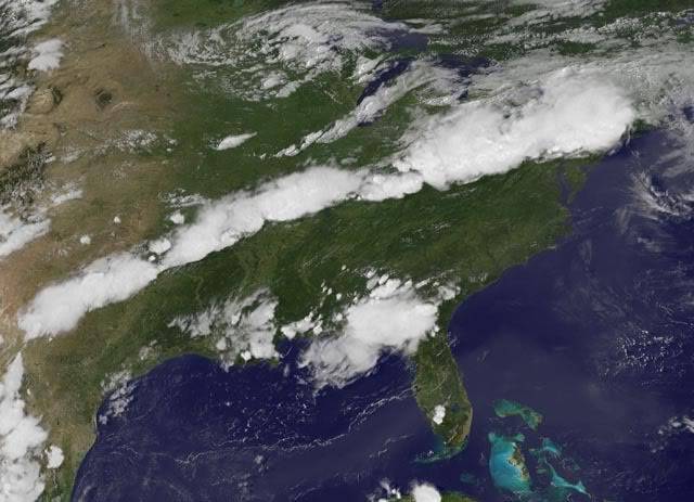
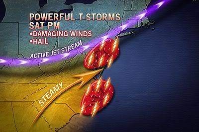
Yesterday's outbreak of severe weather that stretched from the Ohio Valley to southern New England made for a bad day for millions of people as powerful thunderstorms left a path of destruction spanning hundreds of miles.
At least two people were killed and at least five others injured as the storms, many packing winds in excess of 60 mph, swept east ahead of an approaching front. More than 400 reports of severe weather or damage were compiled by the Storm Prediction Center from around 1:30 p.m. to shortly before midnight eastern time. Most of the reports were related to strong and damaging wind gusts. A tornado spawned by one storm led to numerous downed trees and building damage in Elmira, N.Y.

The main squall line yesterday afternoon was over 1,600 miles long stretching from Texas to the New England States and directly affected more than 40 million people.
A pair of weather trouble-makers will be responsible for an encore performance today of powerful thunderstorms over the Ohio Valley and from the Mid-Atlantic to Southeast. Although the storms won`t rival Thursday`s fierce ones, damaging wind gusts and large hail still loom large. Even the northern High Plains will see a few feisty storms later today.

Fortunately, the scope and magnitude of Thursday's outbreak should not be duplicated across the Southeast later today. Storms will be more scattered today and driven by daytime heating and not so much as the atmospheric conditions that were available yesterday. However, some will still deliver a punch.
The SPC Convective Outlook for today.
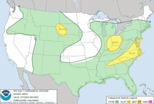
Not to be left out, a fast-moving disturbance riding along the jet stream will allow for a few severe thunderstorms across western North Dakota and far northwestern Nebraska early tonight. The storms will gather momentum, pushing eastward along the Interstate 90 corridor in North Dakota. Parts of South Dakota and Wyoming will be most likely to experience a thunderstorms packing a punch with large hail and damaging wind gusts up to 60 mph later today.
In all for today, the single biggest threat will be damaging wind gusts up to 60 mph, though large hail in excess of golf ball size will also be possible. In addition to the severe weather, a hidden danger in flash flooding, as well as frequent lightning will be accompanied by these clusters of thunderstorms.
On a positive note, the final weekend in July will begin on a much quieter note than the last week of the month ended. The only threat for a few strong thunderstorms will be from the Delmarva Peninsula to the eastern Carolinas, but those will be few-and-far between. This will give some residents some much needed relief as some parts of the United States had several rounds of Severe Weather throughout the week.
Last edited by emcf30 on Fri Jul 27, 2012 11:30 am; edited 1 time in total

emcf30- Posts : 975
Reputation : 10
Join date : 2012-07-16
Age : 93
Re: Eyes on the Tropics and More Severe Weather
![]() by Tropic Bunker Fri Jul 27, 2012 8:50 am
by Tropic Bunker Fri Jul 27, 2012 8:50 am

Tropic Bunker- Posts : 70
Reputation : 1
Join date : 2012-07-16
Age : 86
Location : Miami
Re: Eyes on the Tropics and More Severe Weather
![]() by sangria Fri Jul 27, 2012 8:50 am
by sangria Fri Jul 27, 2012 8:50 am

sangria- Admin
- Posts : 2345
Reputation : 55
Join date : 2012-07-16
Re: Eyes on the Tropics and More Severe Weather
![]() by scouter534 Fri Jul 27, 2012 8:55 am
by scouter534 Fri Jul 27, 2012 8:55 am

scouter534- Posts : 128
Reputation : 1
Join date : 2012-07-16
Age : 63
Location : Pompano Beach, FL
Re: Eyes on the Tropics and More Severe Weather
![]() by gomexwx Fri Jul 27, 2012 9:32 am
by gomexwx Fri Jul 27, 2012 9:32 am

gomexwx- Posts : 641
Reputation : 63
Join date : 2012-07-16
Location : On an Acre somewhere on the gulf Coast
emcf30- Posts : 975
Reputation : 10
Join date : 2012-07-16
Age : 93
Re: Eyes on the Tropics and More Severe Weather
![]() by Seawall Fri Jul 27, 2012 10:21 am
by Seawall Fri Jul 27, 2012 10:21 am

Seawall- Posts : 125
Reputation : 3
Join date : 2012-07-16
Re: Eyes on the Tropics and More Severe Weather
![]() by emcf30 Fri Jul 27, 2012 12:28 pm
by emcf30 Fri Jul 27, 2012 12:28 pm

Even tho the right side is cut off
emcf30- Posts : 975
Reputation : 10
Join date : 2012-07-16
Age : 93
Seawall- Posts : 125
Reputation : 3
Join date : 2012-07-16
Re: Eyes on the Tropics and More Severe Weather
![]() by emcf30 Sat Jul 28, 2012 2:06 pm
by emcf30 Sat Jul 28, 2012 2:06 pm
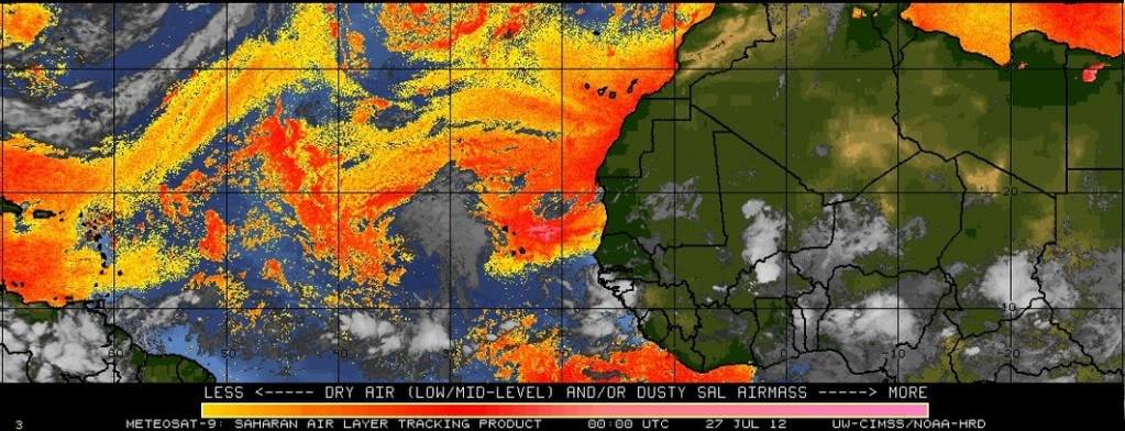
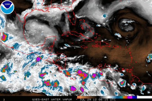
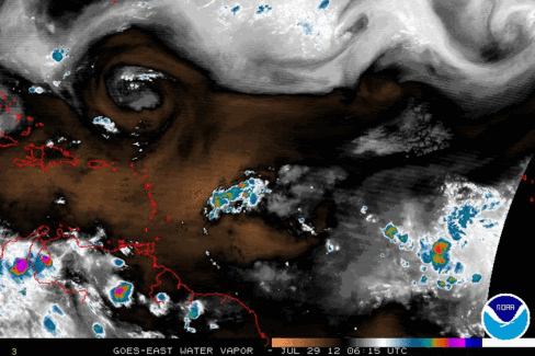
It has been nearly a month since Tropical Storm Debby churned in the eastern Gulf of Mexico, bringing heavy and beneficial rains to parts of Florida. But since the end of June, the overall weather pattern across the Atlantic Tropical Basin has been considerably quiet. The Atlantic is starting to look a little interesting. All kinds of swirls and blobs. Looks like the SAL is starting to get mixed out a tad in the Eastern Atlantic. The entire SAL continues moving to the West towards Florida
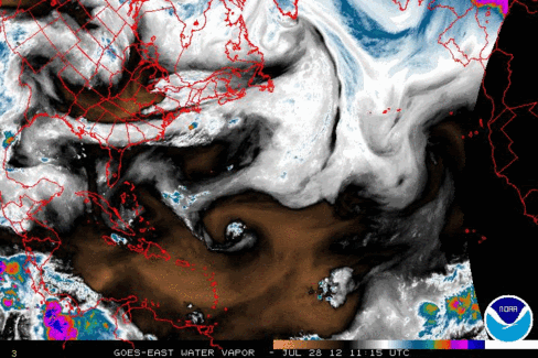
The strong tropical wave we have been watching for a couple of days continues to churn to the West. This system will continue to interact with the dusty and dry air which should limit development throughout the weekend, but that may change heading into early next week.
Beyond the early part of the week, there remains a bit of uncertainty with the track of the storm.
There are two different scenarios after the storm moves into the Eastern Caribbean, it will either track due West into the central and Western Caribbean or to the Northwest.

Another round of severe thunderstorms is set for this afternoon and evening from the Carolinas into the mid-Atlantic. I totally missed this yesterday and only thought these would be a few "Afternoon Garden Variety " storms to contend with. An area of low pressure spinning into the eastern Great Lakes is dragging a cold front into the upper Ohio Valley. To the south and east of the front, warm and humid air is streaming northward into the Mid-Atlantic. Daytime heating will push temperatures into the 90s across the region today, fueling the atmosphere for a round of major storms as the cold front pushes through.
Thunderstorms are already developing quickly across southeastern Pennsylvania and southern New Jersey. This could bring a damaging wind threat to Pennsylvania , Washington D.C., and A New Jersey over the next few hours.
Not only will the East be under the gun, but the Plains will also see the chance for severe thunderstorms this afternoon and evening, where threats for both damaging winds and large hail will be possible.
The current SPC Convective Outlook
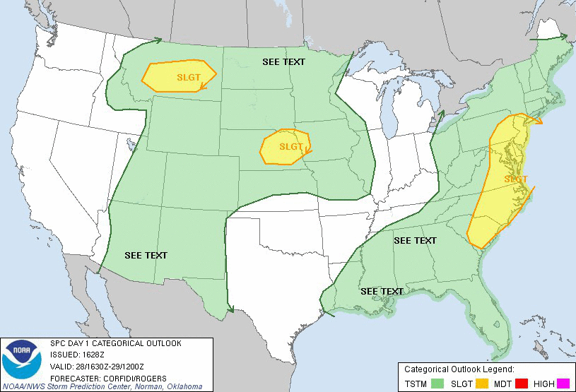
...THERE IS A SLGT RISK OF SVR TSTMS OVER PARTS OF THE MID ATLANTIC
STATES/CAROLINAS...
...THERE IS A SLGT RISK OF SVR TSTMS OVER PARTS OF THE MID MO
VLY/CNTRL PLNS...
...THERE IS A SLGT RISK OF SVR TSTMS OVER PARTS OF THE NRN HIGH
PLNS...
...SYNOPSIS...
STNRY SRN/CNTRL RCKYS/PLNS ANTICYCLONE WILL REMAIN THE DOMINANT
WEATHER FEATURE OVER THE CONUS THROUGH SUN. SEVERAL SMALL SCALE
DISTURBANCES ROTATING AROUND THE HIGH LIKELY WILL ONCE AGAIN GOVERN
LOCATION/TIMING OF DIURNALLY ENHANCED TSTMS...SOME OF WHICH COULD
BECOME STRONG TO SVR.
...MID ATLANTIC/CAROLINAS THIS AFTN/EVE...
WEAK HEIGHT FALLS WILL PERSIST OVER THE MID ATLANTIC SWD INTO THE
CAROLINAS AS BROAD...LARGE SCALE TROUGH CONTINUES TO SLOWLY AMPLIFY
OVER REGION. THE MAIN SOURCE OF ASCENT MAY BE ASSOCIATED WITH
EMBEDDED IMPULSE NOW ENTERING WRN PA...WITH ADDITIONAL SUPPORT
PROVIDED BY UPSTREAM JET STREAK MOVING SE FROM IL/IND.
AT ANY RATE...COMBINATION OF MODEST BACKGROUND ASCENT WITH SFC
HEATING AND VERY MOIST AIR /PW 1.75-2.00 INCHES/ SHOULD LEAD TO THE
DEVELOPMENT OF NUMEROUS AFTN TSTMS FROM CNTRL/ERN PA AND NJ SWD INTO
THE CAROLINAS...DESPITE MODEST MID LVL LAPSE RATES. ACTIVITY SHOULD
BE MOST CONCENTRATED ALONG WEAK W-E COLD FRONT SETTLING SLOWLY S
ACROSS PA/NJ...AND ALONG LEE TROUGH PARALLELING THE BLUE RIDGE
MOUNTAINS FROM MD SSW INTO WRN NC. ANOTHER STORMS MAY FOCUS FARTHER
S AND E ALONG SEA BREEZE BOUNDARIES AND REMNANT OUTFLOW BOUNDARIES
OVER THE ERN CAROLINAS. REF MCD 16303 FOR MORE DETAILS.
25-30 KT UNIDIRECTIONAL WSWLY 700-500 MB FLOW WILL FAVOR THE
FORMATION OF SHORT LINES AND CLUSTERS OF STORMS THAT COULD YIELD
LOCALIZED SWATHS OF DMGG WIND AND PERHAPS MARGINALLY SVR HAIL
THROUGH EARLY TNGT.
...CNTRL PLAINS/MID MO VLY TODAY/TNGT...
SHORTWAVE IMPULSE NOW OVER WRN SD EXPECTED TO TRACK ESE AROUND NRN
SIDE OF UPR RIDGE...REACHING SE SD LATER TODAY AND ERN IA EARLY SUN.
ASCENT WITH THIS FEATURE SHOULD BE FOCUSED ALONG AND E OF WEAK
NW/SE-ORIENTED WARM/STNRY FRONT. THIS FRONT IS THE WRN EXTENSION OF
SAME BOUNDARY NOW OVER PA/NJ...AND SHOULD ADVANCE SLOWLY E/NE
THROUGH THE PERIOD.
WAA/MOISTURE TRANSPORT ABOVE THE FRONTAL SFC SHOULD MAINTAIN
POTENTIAL FOR EPISODES OF ELEVATED TSTMS OVER SE SD...SW MN AND NRN
IA. SOME OF THE STORMS COULD YIELD A SPOT OR TWO OF SVR HAIL. A
POTENTIAL ALSO WILL EXIST FOR SFC-BASED STORMS LATER TODAY IN PARTS
OF NEB AND POSSIBLY SD AS EML CAP LOCALLY IS BREACHED BY SFC
HEATING...FRONTAL UPLIFT...AND ASCENT WITH UPR IMPULSE. AMPLE /30-35
KT/ NWLY DEEP SHEAR WILL EXIST FOR SUSTAINED UPDRAFTS/SUPERCELLS
WITH SVR HAIL AND/OR HIGH WIND THROUGH LATE EVE GIVEN FAIRLY STEEP
MID LVL LAPSE RATES. A SMALL MCS MAY EVOLVE FROM THIS ACTIVITY...OR
DEVELOP SEPARATE FROM IT E OF WARM FRONT. IF SUCH A CLUSTER DOES
INDEED FORM...IT COULD PERSIST INTO EARLY SUN OVER IA AND PERHAPS
NRN MO.
...NRN INTERMOUNTAIN REGION TO NRN PLNS...
SHORTWAVE TROUGH NOW ENTERING SW AB EXPECTED TO CONTINUE ENE AWAY
FROM MT TODAY...BUT ASCENT WITH AN UPSTREAM IMPULSE NOW IN SE ORE
SHOULD AFFECT WRN MT LATER TODAY. WATER VAPOR DATA ALSO SUGGEST
PRESENCE OF A POSSIBLE WEAKER DISTURBANCE IN ERN ID THAT WOULD
INFLUENCE SRN MT THIS AFTN. THESE FEATURES...AND DIFFERENTIAL
HEATING...COULD ASSIST DIURNAL TSTM DEVELOPMENT OVER ID/MT... WHERE
30-35 KT WSWLY DEEP SHEAR WILL EXIST ON NRN FRINGE OF UPR RIDGE.
MOISTURE WILL REMAIN RELATIVELY LIMITED...WITH THE GREATEST VALUES
/AROUND 1 INCH PER GPS-SATELLITE PW DATA/ EXPECTED OVER W CNTRL MT.
BUT GIVEN STEEP LOW TO MID LVL LAPSE RATES AND MODERATE
SHEAR...SETUP MAY FOSTER A FEW CELLS WITH SVR HAIL AND HIGH WINDS.
SOME OF THIS ACTIVITY COULD GLANCE NRN/WRN ND TNGT.
...SW U.S...
SEASONABLY STRONG /20-25 KT/ ESELY MID LVL FLOW WILL PREVAIL OVER
FAR SRN PORTIONS OF NM AND AZ TODAY...ON SW FLANK OF UPR RIDGE AND N
OF UPR DISTURBANCE MOVING W ACROSS MEXICO. WITH AMPLE MOISTURE IN
PLACE AND STRONG SFC HEATING LIKELY OVER SRN/WRN NM AND SE AZ
MOUNTAINS...EXPECT NUMEROUS DIURNAL STORMS TO FORM OVER REGION.
THESE COULD EVOLVE INTO A W OR WNW-MOVING CLUSTER POSING A RISK FOR
LOCALLY DMGG WIND INTO S CNTRL AZ BY EVE.
...SOUTH/GULF CST THIS AFTN...
WEAKENING...SWRN EXTENSION OF COLD FRONT THAT IS NOW OVER PA/NJ MAY
SERVE AS A FOCUS FOR A FEW STRONG STORMS OVER THE TN VLY
TODAY...WHERE HI PW VALUES MAY YIELD A WET MICROBURST OR TWO.
FARTHER S...REMNANT MCV INTERACTING WITH GULF CST SEA BREEZE
BOUNDARIES BENEATH WEAK...DIFLUENT UPR FLOW MAY SUPPORT DEVELOPMENT
OF A SCTD STRONG STORMS/STORM CLUSTERS WITH WET MICROBURSTS.
PEACE
emcf30- Posts : 975
Reputation : 10
Join date : 2012-07-16
Age : 93
Re: Eyes on the Tropics and More Severe Weather
![]() by emcf30 Sat Jul 28, 2012 2:14 pm
by emcf30 Sat Jul 28, 2012 2:14 pm

emcf30- Posts : 975
Reputation : 10
Join date : 2012-07-16
Age : 93
Re: Eyes on the Tropics and More Severe Weather
![]() by sangria Sat Jul 28, 2012 2:22 pm
by sangria Sat Jul 28, 2012 2:22 pm
Also....wonder what the ULL at 25N 60W could do....is it favorable to work it's way down to mid or lower levels?
sangria- Admin
- Posts : 2345
Reputation : 55
Join date : 2012-07-16
Re: Eyes on the Tropics and More Severe Weather
![]() by emcf30 Sat Jul 28, 2012 2:45 pm
by emcf30 Sat Jul 28, 2012 2:45 pm
emcf30- Posts : 975
Reputation : 10
Join date : 2012-07-16
Age : 93
Re: Eyes on the Tropics and More Severe Weather
![]() by sangria Sat Jul 28, 2012 3:17 pm
by sangria Sat Jul 28, 2012 3:17 pm
In order to view the chat box, you must be a member, but it is where a great deal of discussion takes place, around the what, why, and how's in relation to the different weather aspects that are currently happening.......
sangria- Admin
- Posts : 2345
Reputation : 55
Join date : 2012-07-16
Re: Eyes on the Tropics and More Severe Weather
![]() by emcf30 Sat Jul 28, 2012 4:14 pm
by emcf30 Sat Jul 28, 2012 4:14 pm
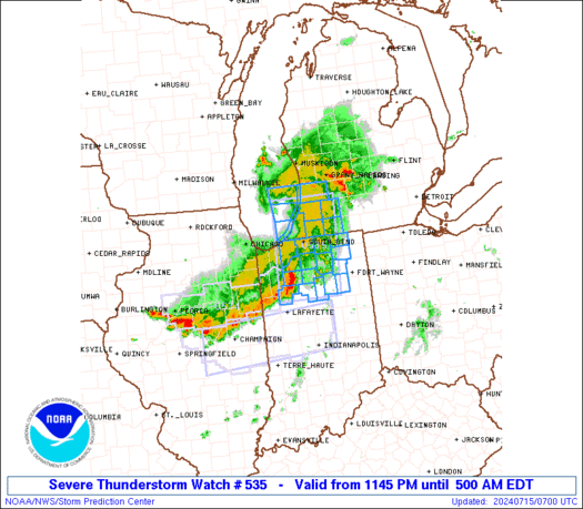
URGENT - IMMEDIATE BROADCAST REQUESTED
SEVERE THUNDERSTORM WATCH NUMBER 535
NWS STORM PREDICTION CENTER NORMAN OK
135 PM EDT SAT JUL 28 2012
THE NWS STORM PREDICTION CENTER HAS ISSUED A
SEVERE THUNDERSTORM WATCH FOR PORTIONS OF
SOUTHWEST CONNECTICUT
DISTRICT OF COLUMBIA
DELAWARE
CENTRAL AND EASTERN MARYLAND
NEW JERSEY
SOUTHEASTERN NEW YORK
SOUTHERN AND EASTERN PENNSYLVANIA
NORTHERN AND EASTERN VIRGINIA
THE EASTERN WEST VIRGINIA PANHANDLE
COASTAL WATERS
EFFECTIVE THIS SATURDAY AFTERNOON AND EVENING FROM 135 PM UNTIL
1000 PM EDT.
HAIL TO 1.5 INCHES IN DIAMETER...THUNDERSTORM WIND GUSTS TO 70
MPH...AND DANGEROUS LIGHTNING ARE POSSIBLE IN THESE AREAS.
THE SEVERE THUNDERSTORM WATCH AREA IS APPROXIMATELY ALONG AND 85
STATUTE MILES EAST AND WEST OF A LINE FROM 55 MILES NORTH OF
NEWARK NEW JERSEY TO 65 MILES SOUTHWEST OF PATUXENT RIVER
MARYLAND. FOR A COMPLETE DEPICTION OF THE WATCH SEE THE
ASSOCIATED WATCH OUTLINE UPDATE (WOUS64 KWNS WOU5).
REMEMBER...A SEVERE THUNDERSTORM WATCH MEANS CONDITIONS ARE
FAVORABLE FOR SEVERE THUNDERSTORMS IN AND CLOSE TO THE WATCH
AREA. PERSONS IN THESE AREAS SHOULD BE ON THE LOOKOUT FOR
THREATENING WEATHER CONDITIONS AND LISTEN FOR LATER STATEMENTS
AND POSSIBLE WARNINGS. SEVERE THUNDERSTORMS CAN AND OCCASIONALLY
DO PRODUCE TORNADOES.
DISCUSSION...SFC HEATING AND CONTINUED ESE ADVANCE OF ERN OH/WRN PA
UPR IMPULSE EXPECTED TO FOSTER A GRADUAL INCREASE IN TSTM COVERAGE
AND STRENGTH THROUGH EARLY TNGT OVER WW REGION. STORMS MAY BE MOST
CONCENTRATED ALONG AND E OF THE BLUE RIDGE...ALONG DIFFUSE LEE
TROUGH FROM SE PA/CNTRL MD SSW INTO VA...AND NEAR SHALLOW BACK-DOOR
BOUNDARY IN NJ/SE NY. PREDOMINANT SVR THREAT SHOULD BE LOCALLY DMGG
WIND DUE TO RELATIVELY HIGH PW AND MODERATELY UNIDIRECTIONAL WSWLY
MID LVL FLOW...ESPECIALLY IN AREAS WHERE SFC HEATING WILL CONTINUE
TO OCCUR THROUGH MID AFTN. MARGINALLY SVR HAIL AND...IN NRN PART OF
WW...VERY HEAVY RAIN ALSO MAY OCCUR. THE STORMS MAY MERGE INTO
SEVERAL LOOSELY ORGANIZED CLUSTERS/BANDS BY MID...WITH A DIMINISHING
SVR THREAT.
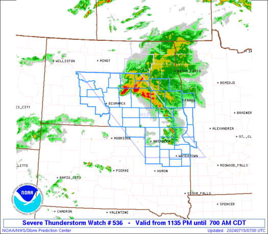
URGENT - IMMEDIATE BROADCAST REQUESTED
SEVERE THUNDERSTORM WATCH NUMBER 536
NWS STORM PREDICTION CENTER NORMAN OK
400 PM EDT SAT JUL 28 2012
THE NWS STORM PREDICTION CENTER HAS ISSUED A
SEVERE THUNDERSTORM WATCH FOR PORTIONS OF
EASTERN NORTH CAROLINA
NORTHEAST SOUTH CAROLINA
COASTAL WATERS
EFFECTIVE THIS SATURDAY AFTERNOON AND EVENING FROM 400 PM UNTIL
1000 PM EDT.
HAIL TO 1 INCH IN DIAMETER...THUNDERSTORM WIND GUSTS TO 70
MPH...AND DANGEROUS LIGHTNING ARE POSSIBLE IN THESE AREAS.
THE SEVERE THUNDERSTORM WATCH AREA IS APPROXIMATELY ALONG AND 45
STATUTE MILES EITHER SIDE OF A LINE FROM 35 MILES WEST OF MYRTLE
BEACH SOUTH CAROLINA TO 35 MILES NORTH NORTHWEST OF CAPE HATTERAS
NORTH CAROLINA. FOR A COMPLETE DEPICTION OF THE WATCH SEE THE
ASSOCIATED WATCH OUTLINE UPDATE (WOUS64 KWNS WOU6).
REMEMBER...A SEVERE THUNDERSTORM WATCH MEANS CONDITIONS ARE
FAVORABLE FOR SEVERE THUNDERSTORMS IN AND CLOSE TO THE WATCH
AREA. PERSONS IN THESE AREAS SHOULD BE ON THE LOOKOUT FOR
THREATENING WEATHER CONDITIONS AND LISTEN FOR LATER STATEMENTS
AND POSSIBLE WARNINGS. SEVERE THUNDERSTORMS CAN AND OCCASIONALLY
DO PRODUCE TORNADOES.
OTHER WATCH INFORMATION...CONTINUE...WW 535...
DISCUSSION...TSTMS NOW FORMING IN ERN SC ARE GROWING IN ZONE OF UPR
DIFLUENCE DOWNSTREAM FROM APPROACHING/AMPLIFYING UPR IMPULSE NOW
OVER THE OH VLY. THE STORMS ARE FORMING WITHIN AN AXIS OF DEEP/RICH
MOISTURE AND SUFFICIENT UNIDIRECTIONAL WSWLY MID/UPR LVL FLOW TO
SUPPORT STORM ORGANIZATION/SUSTENANCE. THE ACTIVITY MAY EVOLVE INTO
ONE OR TWO NE-MOVING CLUSTERS...WITH SMALL BOWING SEGMENTS POSING A
RISK FOR DMGG WIND.
emcf30- Posts : 975
Reputation : 10
Join date : 2012-07-16
Age : 93
Re: Eyes on the Tropics and More Severe Weather
![]() by emcf30 Sat Jul 28, 2012 6:27 pm
by emcf30 Sat Jul 28, 2012 6:27 pm


emcf30- Posts : 975
Reputation : 10
Join date : 2012-07-16
Age : 93
Re: Eyes on the Tropics and More Severe Weather
![]() by gomexwx Sat Jul 28, 2012 6:58 pm
by gomexwx Sat Jul 28, 2012 6:58 pm
gomexwx- Posts : 641
Reputation : 63
Join date : 2012-07-16
Location : On an Acre somewhere on the gulf Coast
Re: Eyes on the Tropics and More Severe Weather
![]() by sangria Sat Jul 28, 2012 6:59 pm
by sangria Sat Jul 28, 2012 6:59 pm
sangria- Admin
- Posts : 2345
Reputation : 55
Join date : 2012-07-16

Tropic Bunker- Posts : 70
Reputation : 1
Join date : 2012-07-16
Age : 86
Location : Miami

Tropic Bunker- Posts : 70
Reputation : 1
Join date : 2012-07-16
Age : 86
Location : Miami
Re: Eyes on the Tropics and More Severe Weather
![]() by emcf30 Sun Jul 29, 2012 9:14 am
by emcf30 Sun Jul 29, 2012 9:14 am
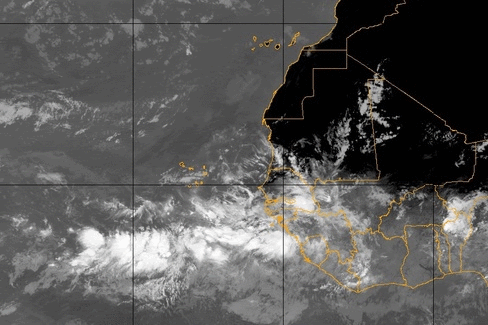
North America is in an unfavorable phase of the Madden Julian Oscillation which is still promoting dry air and little in the way of tropical development in the Atlantic and east Pacific. This will change, beginning south of Mexico over the next week.

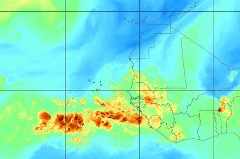
Lets take a look at some Atlantic Satellite imagery

Models are starting to latch on to some development over the next couple of weeks although with Genesis in different places.
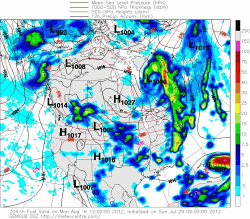
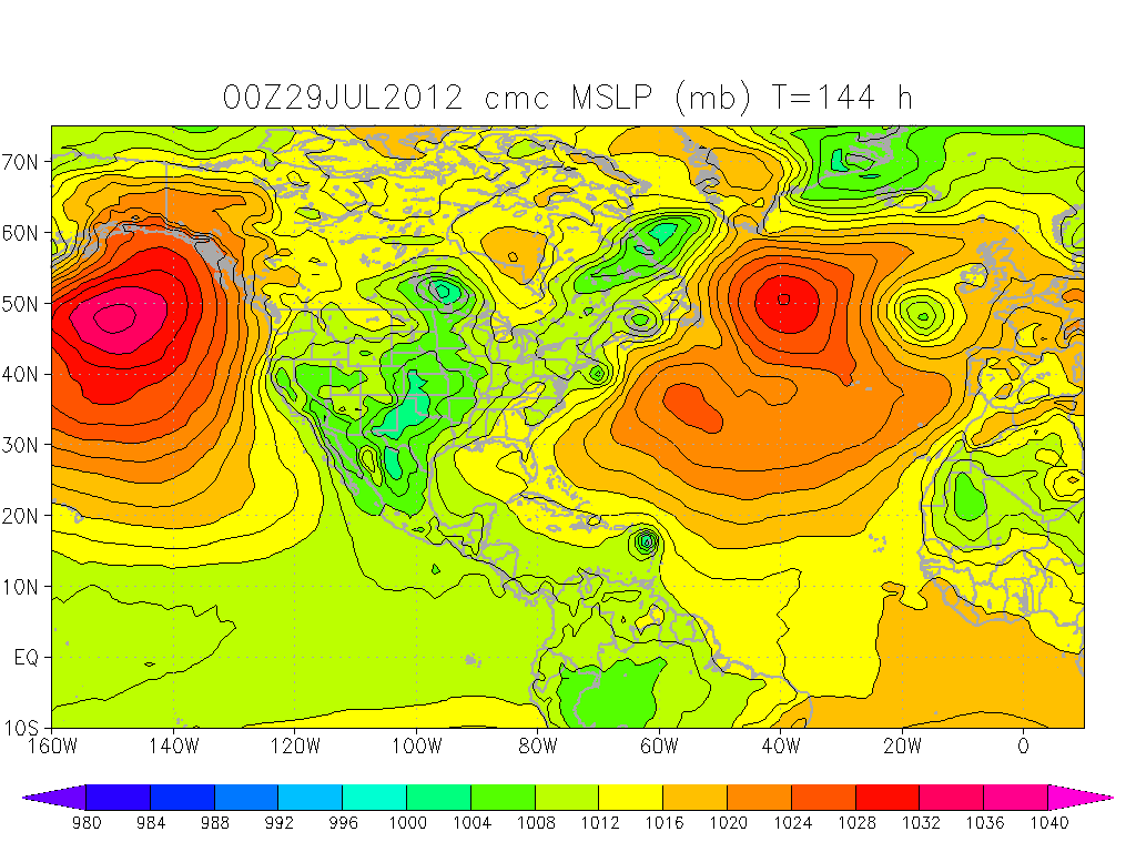
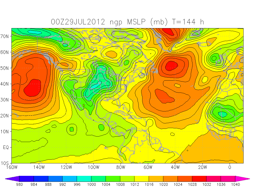


You get the picture. Multiple models show development of some sort. I believe this is in reaction to a more favorable MJO moving into our sector and the SAL and shear dissipating in the Western Atlantic and Caribbean.
A tropical storm quickly developed in the western Pacific Ocean early Saturday morning. Tropical Storm Saola (10W) will brush Luzon Island in the Philippines on its way toward impacting Taiwan next week.
Saola is currently moving toward the northwest and will continue on this path over the next few days. On this path, Saola will pass just north of Luzon Island in the Philippines Sunday and Sunday night. However, some heavy rain and gusty winds from Saola will brush northeast portions of Luzon during the day Sunday. Local mets in Luzon are calling for 3-5 inches of rain and wind gusts to 50 mph will be possible.
As Saola continues its northwest motion early next week, the storm will encounter favorable environmental conditions, allowing Saola to rapidly strengthen into a typhoon before reaching Taiwan. I would not be surprised to see a Category 3 or 4 come ashore in Taiwan. To make matters worse, current computer guidance suggests Saola will slow its forward speed early next week, perhaps even stalling just east of Taiwan. This will allow several days of heavy rainfall to impact Taiwan. This will be a life threatening event for Taiwan.
Rainfall totals will likely exceed 10-20 inches in many areas next week, and could even exceed an amazing 50 inches in the mountainous areas, especially if the storm stalls just east of Taiwan. Sadly, we will be seeing some bad news come out of this region in coming days.


Weather Round-up
Meanwhile back in the states, the East Coast will have to endure another day of scattered showers and thunderstorms in what has seemingly become a daily occurrence. Air conditioners will be humming across the Plains where the heat will be in full force. The only relief will be short-lived in hit-or-miss thunderstorms from Texas to the U.S. and Canada border. Highs in the 90s will be common, with triple-digits covering northern Texas to western Kansas. Similar weather will take up residence across the Southeast, where temperatures will still surge into the 90s despite the threat for a few afternoon thunderstorms.
West Coast residents will enjoy beautiful weather, while the only potential problem will be across the Rocky Front Range. Here, numerous showers and thunderstorms will interrupt outdoor plans. As usual, the hottest spot will be the Desert Southwest, where triple digits will be common.
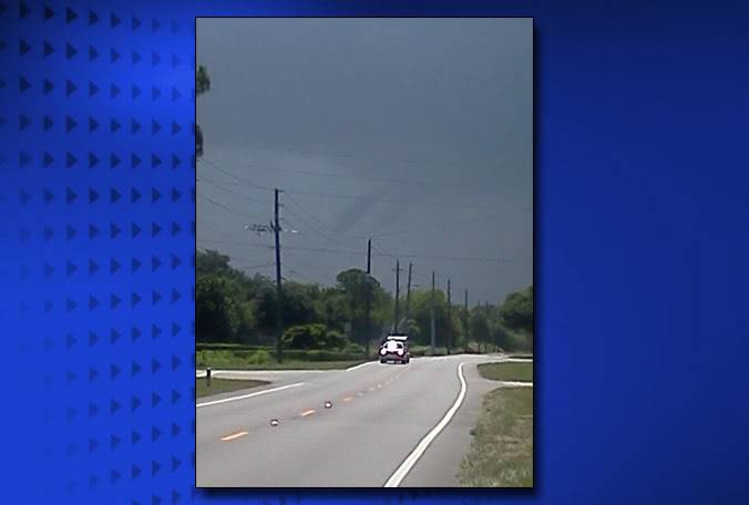
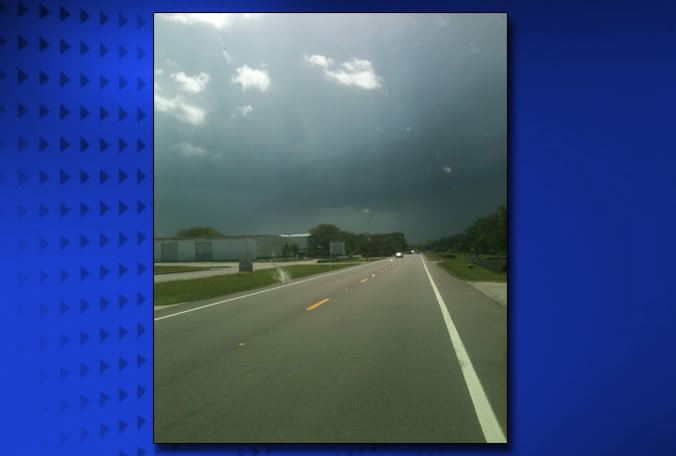
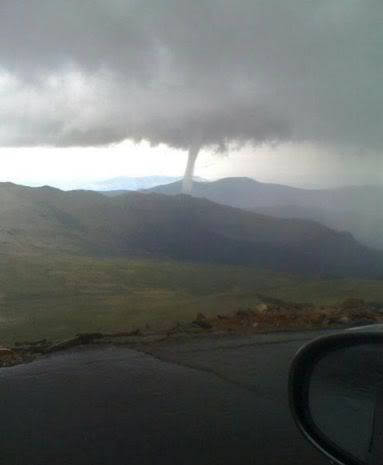
Yesterday, there was on official report of a tornado per the SPC
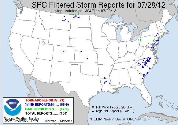
However, we know there were at least two with the Melbourne touchdown. Here is a Twit pic of the Colorado Tornado from yesterday.
And last but not least, the SPC Convective Outlook for today.

AY 1 CONVECTIVE OUTLOOK
NWS STORM PREDICTION CENTER NORMAN OK
0739 AM CDT SUN JUL 29 2012
VALID 291300Z - 301200Z
...THERE IS A SLGT RISK OF SVR TSTMS THIS AFTERNOON INTO EARLY
TONIGHT FOR NE ND AND NRN MN...
...SYNOPSIS...
A PERSISTENT MIDLEVEL HIGH WILL REMAIN ANCHORED OVER THE SRN HIGH
PLAINS THROUGH TOMORROW...WITH A DOWNSTREAM TROUGH OVER THE ERN
STATES. WITHIN A BELT OF STRONGER WLYS AROUND THE PERIPHERY OF THE
HIGH...A SERIES OF EMBEDDED SHORTWAVE TROUGHS WILL MOVE SEWD FROM
SRN SK/MB TO NW MN...AND FROM THE MN/IA BORDER TO IL. WEAK SURFACE
REFLECTIONS OF EACH MIDLEVEL WAVE ARE EXPECTED ALONG A NW-SE
ORIENTED BAROCLINIC ZONE /MARKING THE NE EDGE OF THE HOT PLAINS AIR
MASS/...WHERE THE ZONES OF LOW-LEVEL CONVERGENCE/WAA WILL HELP FOCUS
THUNDERSTORM DEVELOPMENT THROUGH TONIGHT.
...ND/MN THIS AFTERNOON INTO EARLY TONIGHT...
STRONG SURFACE HEATING WILL TAKE PLACE TODAY ACROSS THE
DAKOTAS/MN...IN ADVANCE OF THE MIDLEVEL TROUGH AND WEAK SURFACE
REFLECTION EXPECTED TO MOVE SEWD OVER NE ND/NW MN THIS EVENING
THROUGH TONIGHT. THOUGH LOW-LEVEL MOISTURE IS NOT PARTICULARLY RICH
ACROSS THE NRN PLAINS...AFTERNOON DEWPOINTS IN THE LOWER 60S WITH
SURFACE TEMPERATURES WELL INTO THE 90S WILL PROMOTE MLCAPE NEAR 2000
J/KG. THIS DEGREE OF BUOYANCY WILL BE SUFFICIENT FOR ORGANIZED
SEVERE STORMS GIVEN THE EXPECTED 35-45 KT WNWLY DEEP-LAYER SHEAR. A
CLUSTER OR TWO OF STORMS IS EXPECTED TO DEVELOP BY MID-LATE
AFTERNOON NEAR THE NE ND/SW MB BORDER ALONG THE SURFACE WIND
SHIFT...AND THEN MOVE SEWD INTO NW MN THROUGH LATE EVENING/EARLY
OVERNIGHT. INVERTED-V PROFILES WILL PROMOTE A RISK OF DAMAGING
OUTFLOW WINDS...WHILE MODERATE INSTABILITY AND THE POSSIBILITY OF
SUPERCELL STRUCTURES WILL SUPPORT A RISK FOR LARGE HAIL.
...IA/MO/IL THIS AFTERNOON...
WEAK ELEVATED THUNDERSTORMS PERSIST THIS MORNING IN THE ZONE OF
LOW-LEVEL WAA OVER CENTRAL AND ERN IA/MO...FED BY A 35 KT WSWLY LLJ.
THIS CONVECTION WILL LIKELY DIMINISH BY MIDDAY AS LOW-LEVEL FLOW
CONTINUES TO VEER/WEAKEN...AND LOW-LEVEL CONVERGENCE ALONG THE
FRONT/DIFFERENTIAL HEATING BOUNDARY WILL PROMOTE NEW THUNDERSTORM
DEVELOPMENT THIS AFTERNOON NEAR THE NE MO/SE IA BORDER. DEEP-LAYER
WIND PROFILES WILL BE SUFFICIENT FOR ORGANIZED SEVERE STORMS /NWLY
EFFECTIVE BULK SHEAR AROUND 40 KT/...THOUGH MLCAPE IS UNLIKELY TO
EXCEED 1000-1500 J/KG AS A RESULT OF HOT SURFACE TEMPERATURES AND
AFTERNOON DEWPOINTS MIXING INTO THE UPPER 50S TO LOWER 60S. THERE
IS ALSO THE TYPICAL UNCERTAINTY REGARDING HOW FAR E THE CLOUDS WILL
CLEAR AND ALLOW THE STRONGER SURFACE HEATING. THUS...GIVEN THE
RATHER MODEST MOISTURE/BUOYANCY...WILL OPT TO JUST MAINTAIN LOW
WIND/HAIL PROBABILITIES IN THIS OUTLOOK UPDATE.
...SRN LA TO THE COASTAL CAROLINAS THIS AFTERNOON...
A WEAK STALLED SURFACE FRONT AND A MIDLEVEL CYCLONIC SHEAR AXIS FROM
THE CAROLINAS TO THE GULF COAST WILL COMBINE WITH DAYTIME HEATING TO
SUPPORT SCATTERED THUNDERSTORMS THIS AFTERNOON. MLCAPE NEAR 3000
J/KG WILL PROMOTE STRONG UPDRAFTS AND PRECIPITATION LOADING...WHILE
SOME DRYING FROM THE NW IN THE 700-500 MB LAYER WILL RESULT IN DCAPE
OF 1000-1500 J/KG AND THE POTENTIAL FOR STRONG DOWNDRAFTS WITH
PULSE-TYPE STORMS THIS AFTERNOON. ISOLATED DAMAGING GUSTS WILL BE
POSSIBLE WITH THE STRONGER WET MICROBURSTS.
emcf30- Posts : 975
Reputation : 10
Join date : 2012-07-16
Age : 93
Re: Eyes on the Tropics and More Severe Weather
![]() by scouter534 Sun Jul 29, 2012 9:26 am
by scouter534 Sun Jul 29, 2012 9:26 am
scouter534- Posts : 128
Reputation : 1
Join date : 2012-07-16
Age : 63
Location : Pompano Beach, FL
Re: Eyes on the Tropics and More Severe Weather
![]() by sangria Sun Jul 29, 2012 9:31 am
by sangria Sun Jul 29, 2012 9:31 am
How about the midwest today? Could the line starting to move into IL makes it's way across to IN? Race time is 1:00pm EDT........
sangria- Admin
- Posts : 2345
Reputation : 55
Join date : 2012-07-16
Re: Eyes on the Tropics and More Severe Weather
![]() by emcf30 Sun Jul 29, 2012 9:39 am
by emcf30 Sun Jul 29, 2012 9:39 am
sangria wrote:Great blog e.......that TS headed toward Taiwan has the potential to be devastating......sure hope it does not stall just east of there!!!
How about the midwest today? Could the line starting to move into IL makes it's way across to IN? Race time is 1:00pm EDT........
I think it is going to be beautiful during the day, with highs around 88 to 90, somewhere in that area. The storms , I believe will hold out until later on tonight. So, perfect racing weather
emcf30- Posts : 975
Reputation : 10
Join date : 2012-07-16
Age : 93
Re: Eyes on the Tropics and More Severe Weather
![]() by Seawall Sun Jul 29, 2012 9:40 am
by Seawall Sun Jul 29, 2012 9:40 am
Seawall- Posts : 125
Reputation : 3
Join date : 2012-07-16
» Severe Weather Outbreak
» Ernesto - 90L - Severe Weather Threat
» Tropical Depression #5 is Born - Severe Weather
» Ernesto, Florence, And Severe Weather At Home


» summer 2019 hurricane season
» April-May Florida weather and local events etc
» NASCAR 2019
» Late January through February outlook
» FLORIDA/ALABAMA AND THE HOLIDAY SEASON WEATHER
» NASCAR 2018
» CLOSED Florida/Alabama Blog - October Tropical Mischief