


CLOSED 4/2/17 Florida/Alabama Weather Blog
:: Florida Blog
Page 7 of 9 •  1, 2, 3, 4, 5, 6, 7, 8, 9
 ![]()
Re: CLOSED 4/2/17 Florida/Alabama Weather Blog
![]() by LargoFL Tue Apr 11, 2017 2:04 pm
by LargoFL Tue Apr 11, 2017 2:04 pm


LargoFL- Posts : 10724
Reputation : 130
Join date : 2017-03-05
Re: CLOSED 4/2/17 Florida/Alabama Weather Blog
![]() by BillsfaninSoFla Tue Apr 11, 2017 2:06 pm
by BillsfaninSoFla Tue Apr 11, 2017 2:06 pm
BillsfaninSoFla- Posts : 1966
Reputation : 52
Join date : 2017-03-05
Re: CLOSED 4/2/17 Florida/Alabama Weather Blog
![]() by LargoFL Tue Apr 11, 2017 2:08 pm
by LargoFL Tue Apr 11, 2017 2:08 pm
good luck next few days down there on getting some rain Billsfan!!!BillsfaninSoFla wrote:Hi Largo... Well, I'd sure like the rain though.
LargoFL- Posts : 10724
Reputation : 130
Join date : 2017-03-05
Re: CLOSED 4/2/17 Florida/Alabama Weather Blog
![]() by LargoFL Tue Apr 11, 2017 2:10 pm
by LargoFL Tue Apr 11, 2017 2:10 pm
LargoFL- Posts : 10724
Reputation : 130
Join date : 2017-03-05
Re: CLOSED 4/2/17 Florida/Alabama Weather Blog
![]() by JRnOldsmar Tue Apr 11, 2017 2:23 pm
by JRnOldsmar Tue Apr 11, 2017 2:23 pm
sangria wrote:Anybody know where to find this map? This one is from 8am. All I can find is an interactive map that loses the fire icons when you zoom in, and doesn't have any detailed info. This was posted on Twitter..
Hey San. I'm guessing that the interactive map that you found is this one.
The zoom works, but it's like watching all the leaves fall from a large maple. It is horribly slow, but seems to get there, eventually. After each step, go have a cup of coffee. I don't see that there is a lot of information here, but I did this:
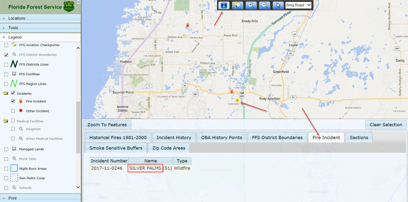
Click the Identify button. (take a sip of coffee)
Then zoom/drag to where you want to go (double click or use buttons) -- (then have a cup of coffee)
Click on the fire you want. (then have another cup of coffee)
When the window at the bottom appears, click on Fire Incident. (another sip of coffee)
In this case, I then googled 'silver palms pasco', and found the news article.
Then you can Clear Selection and find another fire.
Hope you can handle a lot of coffee!!!
I'm still looking. I remember seeing something like this one before. I thought it had more info on it, but that was years ago.

JRnOldsmar- Posts : 828
Reputation : 48
Join date : 2017-03-05
Location : Oldsmar, FL
Re: CLOSED 4/2/17 Florida/Alabama Weather Blog
![]() by JRnOldsmar Tue Apr 11, 2017 2:26 pm
by JRnOldsmar Tue Apr 11, 2017 2:26 pm
Florida Fire PDF
JRnOldsmar- Posts : 828
Reputation : 48
Join date : 2017-03-05
Location : Oldsmar, FL
Re: CLOSED 4/2/17 Florida/Alabama Weather Blog
![]() by JRnOldsmar Tue Apr 11, 2017 2:31 pm
by JRnOldsmar Tue Apr 11, 2017 2:31 pm
fires.globalincidentmap.com
JRnOldsmar- Posts : 828
Reputation : 48
Join date : 2017-03-05
Location : Oldsmar, FL
Re: CLOSED 4/2/17 Florida/Alabama Weather Blog
![]() by LargoFL Tue Apr 11, 2017 2:33 pm
by LargoFL Tue Apr 11, 2017 2:33 pm
LargoFL- Posts : 10724
Reputation : 130
Join date : 2017-03-05
Re: CLOSED 4/2/17 Florida/Alabama Weather Blog
![]() by JRnOldsmar Tue Apr 11, 2017 2:41 pm
by JRnOldsmar Tue Apr 11, 2017 2:41 pm
earthobservatory
and another, but I don't see any data, and few fires are showing (and not the same as the global incident map)
climatecentral
JRnOldsmar- Posts : 828
Reputation : 48
Join date : 2017-03-05
Location : Oldsmar, FL
Re: CLOSED 4/2/17 Florida/Alabama Weather Blog
![]() by JRnOldsmar Tue Apr 11, 2017 2:41 pm
by JRnOldsmar Tue Apr 11, 2017 2:41 pm
LargoFL wrote:Another pot of Coffee is now perking LOL
Thanks, Largo. Just what I needed. I already have the jitters.
JRnOldsmar- Posts : 828
Reputation : 48
Join date : 2017-03-05
Location : Oldsmar, FL
Re: CLOSED 4/2/17 Florida/Alabama Weather Blog
![]() by LargoFL Tue Apr 11, 2017 3:31 pm
by LargoFL Tue Apr 11, 2017 3:31 pm
National Weather Service Tampa Bay Ruskin FL
255 PM EDT Tue Apr 11 2017
.SHORT TERM (Tonight - Wednesday)...
Upper level ridging from the Gulf extending northeast across
Florida and up along the eastern seaboard will remain in
place through Wednesday, but will weaken some on Wednesday
as a short wave trough moving across the southeastern states
impinges upon it. At the surface high pressure offshore the
mid Atlantic coast will remain in place through the period
with an easterly wind flow continuing across the entire
forecast area. A dry subsident air mass will keep rain out
of the forecast tonight, however on Wednesday less
suppression from the upper ridge combined with enough low
level moisture may support some low-topped showers within
the easterly flow across central interior and across
southwest Florida during the afternoon where the best
moisture will reside and have included a low pop mention (20
percent) in these areas, otherwise dry weather will
continue. Temperatures tonight will run near seasonal norms
with lows in the upper 50s to lower 60s. Highs on Wednesday
with continue to run a few degrees above normal with highs
climbing to around 80 to the lower 80s along the coast, and
mid 80s inland.
LargoFL- Posts : 10724
Reputation : 130
Join date : 2017-03-05
Re: CLOSED 4/2/17 Florida/Alabama Weather Blog
![]() by LargoFL Tue Apr 11, 2017 3:32 pm
by LargoFL Tue Apr 11, 2017 3:32 pm
LMAO, I live on the stuff for sure.JRnOldsmar wrote:LargoFL wrote:Another pot of Coffee is now perking LOL
Thanks, Largo. Just what I needed. I already have the jitters.
LargoFL- Posts : 10724
Reputation : 130
Join date : 2017-03-05
Re: CLOSED 4/2/17 Florida/Alabama Weather Blog
![]() by LargoFL Tue Apr 11, 2017 3:33 pm
by LargoFL Tue Apr 11, 2017 3:33 pm
LargoFL- Posts : 10724
Reputation : 130
Join date : 2017-03-05
Re: CLOSED 4/2/17 Florida/Alabama Weather Blog
![]() by sangria Tue Apr 11, 2017 5:12 pm
by sangria Tue Apr 11, 2017 5:12 pm
LargoFL wrote:Sang are you ok with those fires in your area? man fires all over the state huh.
Hey Largo!
Yep, all is well at my house. The wind direction must have changed overnight or it picked up speed, when I got up this morning it smelled like the whole county was on fire! That had to have come from the fire to my ENE. I haven't had a chance to see what's happening in the state today, but that's my next stop.

sangria- Admin
- Posts : 2345
Reputation : 55
Join date : 2012-07-16
Re: CLOSED 4/2/17 Florida/Alabama Weather Blog
![]() by sangria Tue Apr 11, 2017 5:20 pm
by sangria Tue Apr 11, 2017 5:20 pm
JRnOldsmar wrote:
Hey San. I'm guessing that the interactive map that you found is this one.
The zoom works, but it's like watching all the leaves fall from a large maple. It is horribly slow, but seems to get there, eventually. After each step, go have a cup of coffee. I don't see that there is a lot of information here, but I did this:
Click the Identify button. (take a sip of coffee)
Then zoom/drag to where you want to go (double click or use buttons) -- (then have a cup of coffee)
Click on the fire you want. (then have another cup of coffee)
When the window at the bottom appears, click on Fire Incident. (another sip of coffee)
In this case, I then googled 'silver palms pasco', and found the news article.
Then you can Clear Selection and find another fire.
Hope you can handle a lot of coffee!!!
I'm still looking. I remember seeing something like this one before. I thought it had more info on it, but that was years ago.
LOL JR,
I gave up coffee a few years ago, so I would be up a creek without a paddle! I guess my limited patience is why I didn't think there was any info on that map.
Thanks for the other links. I don't get why this one only shows the Orlando fires. Maybe size? http://fires.globalincidentmap.com/home.php
I'm glad you found the link to the one I saw on twitter. It was bugging me that I couldn't find it, I can usually find anything. :-)
sangria- Admin
- Posts : 2345
Reputation : 55
Join date : 2012-07-16
Re: CLOSED 4/2/17 Florida/Alabama Weather Blog
![]() by sangria Tue Apr 11, 2017 5:46 pm
by sangria Tue Apr 11, 2017 5:46 pm
sangria- Admin
- Posts : 2345
Reputation : 55
Join date : 2012-07-16
Re: CLOSED 4/2/17 Florida/Alabama Weather Blog
![]() by JRnOldsmar Tue Apr 11, 2017 9:42 pm
by JRnOldsmar Tue Apr 11, 2017 9:42 pm
sangria wrote:I gave up coffee a few years ago
Bourbon works well, too. Just not in the same manner.
JRnOldsmar- Posts : 828
Reputation : 48
Join date : 2017-03-05
Location : Oldsmar, FL
Re: CLOSED 4/2/17 Florida/Alabama Weather Blog
![]() by LargoFL Wed Apr 12, 2017 3:57 am
by LargoFL Wed Apr 12, 2017 3:57 am
LargoFL- Posts : 10724
Reputation : 130
Join date : 2017-03-05
Re: CLOSED 4/2/17 Florida/Alabama Weather Blog
![]() by LargoFL Wed Apr 12, 2017 5:05 am
by LargoFL Wed Apr 12, 2017 5:05 am
National Weather Service Tampa Bay Ruskin FL
232 AM EDT Wed Apr 12 2017
.SHORT TERM (Today - Thursday)...
The southern end of a weak mid to upper-level trough will
move slowly eastward across the northern Gulf as the
northern stream races northeast leaving it behind. As the
trough approaches, the mid-level ridge will push eastward
into the Atlantic, which will reduce the subsidence over the
region later today. To complicate matters further, a large
area of enhanced low-level moisture associated with a wind
speed max will be approaching south Florida from the east
this morning, then move across the southern half of Florida
this afternoon and evening. By the time this feature reaches
the west coast of Florida, there will be an opposing sea
breeze boundary near the coast. The most likely areas to see
showers will be across Charlotte and Lee counties this
afternoon and evening, but a few showers may extend as far
north as the Tampa Bay area. Moisture is limited to the
lowest 10kft, and some subsidence and dry air will remain
above that. This should keep the chances for thunderstorms
too low to mention.
Low-level moisture will linger through tonight, especially
south of the Tampa Bay area. Any evening showers should end
before midnight, but clouds may hang around for a while.
Low-level moisture will not be as deep on Thursday, but a
sea breeze is likely to form right at the coast again.
Clouds should not be as prevalent due to the decreased
moisture, and rain chances will be too low to include in the
forecast.
.MID/LONG TERM (Thursday night - Tuesday)...
No significant weather to speak of throughout the mid/long
term forecast period. High pressure will control the weather
across the area into the middle part of next week. This
will keep our rain chances essentially zero into early next
week. Placement of high pressure ridge will keep the area in
a predominant easterly flow through much of the period.
Mostly sunny skies can be expected each day with
temperatures remaining above normal with most areas topping
out in the mid 80s with some upper 80s likely in spots.
&&
LargoFL- Posts : 10724
Reputation : 130
Join date : 2017-03-05
Re: CLOSED 4/2/17 Florida/Alabama Weather Blog
![]() by LargoFL Wed Apr 12, 2017 6:26 am
by LargoFL Wed Apr 12, 2017 6:26 am
LargoFL- Posts : 10724
Reputation : 130
Join date : 2017-03-05
Re: CLOSED 4/2/17 Florida/Alabama Weather Blog
![]() by LargoFL Wed Apr 12, 2017 6:26 am
by LargoFL Wed Apr 12, 2017 6:26 am
LargoFL- Posts : 10724
Reputation : 130
Join date : 2017-03-05
Re: CLOSED 4/2/17 Florida/Alabama Weather Blog
![]() by LargoFL Wed Apr 12, 2017 8:37 am
by LargoFL Wed Apr 12, 2017 8:37 am
LargoFL- Posts : 10724
Reputation : 130
Join date : 2017-03-05
Re: CLOSED 4/2/17 Florida/Alabama Weather Blog
![]() by BillsfaninSoFla Wed Apr 12, 2017 8:44 am
by BillsfaninSoFla Wed Apr 12, 2017 8:44 am
Cloudy and coolish.
Thanks for the coffee Largo.
BillsfaninSoFla- Posts : 1966
Reputation : 52
Join date : 2017-03-05
Re: CLOSED 4/2/17 Florida/Alabama Weather Blog
![]() by LargoFL Wed Apr 12, 2017 11:20 am
by LargoFL Wed Apr 12, 2017 11:20 am
your welcome my friend..wish I was getting spittles here by me, whew, its warm and dry..desert like almost lolBillsfaninSoFla wrote:Good morning everyone! Very, very light "spittles" no sprinkles, not enough to register anything.
Cloudy and coolish.
Thanks for the coffee Largo.
LargoFL- Posts : 10724
Reputation : 130
Join date : 2017-03-05
Re: CLOSED 4/2/17 Florida/Alabama Weather Blog
![]() by LargoFL Wed Apr 12, 2017 11:22 am
by LargoFL Wed Apr 12, 2017 11:22 am
 Just imagine if this..was near your barckyard..this in Oviedo fl..
LargoFL- Posts : 10724
Reputation : 130
Join date : 2017-03-05
Re: CLOSED 4/2/17 Florida/Alabama Weather Blog
![]() by LargoFL Wed Apr 12, 2017 11:23 am
by LargoFL Wed Apr 12, 2017 11:23 am
LargoFL- Posts : 10724
Reputation : 130
Join date : 2017-03-05
Re: CLOSED 4/2/17 Florida/Alabama Weather Blog
![]() by LargoFL Wed Apr 12, 2017 11:25 am
by LargoFL Wed Apr 12, 2017 11:25 am
National Weather Service Melbourne FL
1025 AM EDT Wed Apr 12 2017
.DISCUSSION...High pressure ridge will maintain an east-northeast
flow across the area today. A weak inverted trough approaching the
Treasure Coast has increased moisture and is producing isolated to
scattered showers that are moving onshore. Best chance for rain
will be across this area and inland through Okeechobee County into
late morning and afternoon where greatest moisture will reside.
Have increased rain chances and cloud cover based on latest
radar/satellite trends across the Treasure Coast. However,
elsewhere forecast looks on track, remaining mostly dry with
temperatures in the upper 70s to low 80s, possibly mid 80s far
inland.
&&
LargoFL- Posts : 10724
Reputation : 130
Join date : 2017-03-05
Re: CLOSED 4/2/17 Florida/Alabama Weather Blog
![]() by LargoFL Wed Apr 12, 2017 11:26 am
by LargoFL Wed Apr 12, 2017 11:26 am
LargoFL- Posts : 10724
Reputation : 130
Join date : 2017-03-05
Re: CLOSED 4/2/17 Florida/Alabama Weather Blog
![]() by LargoFL Wed Apr 12, 2017 1:13 pm
by LargoFL Wed Apr 12, 2017 1:13 pm

LargoFL- Posts : 10724
Reputation : 130
Join date : 2017-03-05
Re: CLOSED 4/2/17 Florida/Alabama Weather Blog
![]() by LargoFL Wed Apr 12, 2017 1:15 pm
by LargoFL Wed Apr 12, 2017 1:15 pm
LargoFL- Posts : 10724
Reputation : 130
Join date : 2017-03-05
LargoFL- Posts : 10724
Reputation : 130
Join date : 2017-03-05
Re: CLOSED 4/2/17 Florida/Alabama Weather Blog
![]() by LargoFL Wed Apr 12, 2017 1:22 pm
by LargoFL Wed Apr 12, 2017 1:22 pm

LargoFL- Posts : 10724
Reputation : 130
Join date : 2017-03-05
Re: CLOSED 4/2/17 Florida/Alabama Weather Blog
![]() by LargoFL Wed Apr 12, 2017 1:26 pm
by LargoFL Wed Apr 12, 2017 1:26 pm
LargoFL- Posts : 10724
Reputation : 130
Join date : 2017-03-05
Re: CLOSED 4/2/17 Florida/Alabama Weather Blog
![]() by LargoFL Wed Apr 12, 2017 1:28 pm
by LargoFL Wed Apr 12, 2017 1:28 pm

LargoFL- Posts : 10724
Reputation : 130
Join date : 2017-03-05
Re: CLOSED 4/2/17 Florida/Alabama Weather Blog
![]() by LargoFL Wed Apr 12, 2017 1:57 pm
by LargoFL Wed Apr 12, 2017 1:57 pm
LargoFL- Posts : 10724
Reputation : 130
Join date : 2017-03-05
LargoFL- Posts : 10724
Reputation : 130
Join date : 2017-03-05
Re: CLOSED 4/2/17 Florida/Alabama Weather Blog
![]() by StAugustineFL Wed Apr 12, 2017 4:27 pm
by StAugustineFL Wed Apr 12, 2017 4:27 pm
FL fires are bad enough but if I had my druthers I'd choose them over the raging Santa Ana fueled fires in CA which can burn through entire neighborhoods in short order.

StAugustineFL- Posts : 2231
Reputation : 64
Join date : 2012-07-17
Re: CLOSED 4/2/17 Florida/Alabama Weather Blog
![]() by LargoFL Thu Apr 13, 2017 5:24 am
by LargoFL Thu Apr 13, 2017 5:24 am
LargoFL- Posts : 10724
Reputation : 130
Join date : 2017-03-05
Re: CLOSED 4/2/17 Florida/Alabama Weather Blog
![]() by gomexwx Thu Apr 13, 2017 8:07 am
by gomexwx Thu Apr 13, 2017 8:07 am
Morning

gomexwx- Posts : 641
Reputation : 63
Join date : 2012-07-16
Location : On an Acre somewhere on the gulf Coast
Re: CLOSED 4/2/17 Florida/Alabama Weather Blog
![]() by LargoFL Thu Apr 13, 2017 9:25 am
by LargoFL Thu Apr 13, 2017 9:25 am
LOL good Morning gomex.gomexwx wrote:you do realize the Easter Bunny started the tradition of hiding eggs because he was hiding the the evidence that he dated the chicken.....
Morning
LargoFL- Posts : 10724
Reputation : 130
Join date : 2017-03-05
Re: CLOSED 4/2/17 Florida/Alabama Weather Blog
![]() by LargoFL Thu Apr 13, 2017 9:27 am
by LargoFL Thu Apr 13, 2017 9:27 am
LargoFL- Posts : 10724
Reputation : 130
Join date : 2017-03-05
Re: CLOSED 4/2/17 Florida/Alabama Weather Blog
![]() by LargoFL Thu Apr 13, 2017 9:29 am
by LargoFL Thu Apr 13, 2017 9:29 am
LargoFL- Posts : 10724
Reputation : 130
Join date : 2017-03-05
Re: CLOSED 4/2/17 Florida/Alabama Weather Blog
![]() by LargoFL Thu Apr 13, 2017 11:32 am
by LargoFL Thu Apr 13, 2017 11:32 am
LargoFL- Posts : 10724
Reputation : 130
Join date : 2017-03-05
Re: CLOSED 4/2/17 Florida/Alabama Weather Blog
![]() by LargoFL Thu Apr 13, 2017 1:09 pm
by LargoFL Thu Apr 13, 2017 1:09 pm
LargoFL- Posts : 10724
Reputation : 130
Join date : 2017-03-05
Re: CLOSED 4/2/17 Florida/Alabama Weather Blog
![]() by LargoFL Thu Apr 13, 2017 1:20 pm
by LargoFL Thu Apr 13, 2017 1:20 pm
LargoFL- Posts : 10724
Reputation : 130
Join date : 2017-03-05
Re: CLOSED 4/2/17 Florida/Alabama Weather Blog
![]() by LargoFL Thu Apr 13, 2017 1:21 pm
by LargoFL Thu Apr 13, 2017 1:21 pm
National Weather Service Tampa Bay Ruskin FL
1022 AM EDT Thu Apr 13 2017
.DISCUSSION...
Dry high pressure will continue across the area for the next
several days with E/NE flow surging in the evenings and
above normal temperatures. Current forecast is on track with
this and have no update planned.
&&
LargoFL- Posts : 10724
Reputation : 130
Join date : 2017-03-05
Re: CLOSED 4/2/17 Florida/Alabama Weather Blog
![]() by LargoFL Thu Apr 13, 2017 1:22 pm
by LargoFL Thu Apr 13, 2017 1:22 pm
LargoFL- Posts : 10724
Reputation : 130
Join date : 2017-03-05
Re: CLOSED 4/2/17 Florida/Alabama Weather Blog
![]() by sangria Thu Apr 13, 2017 3:03 pm
by sangria Thu Apr 13, 2017 3:03 pm
sangria- Admin
- Posts : 2345
Reputation : 55
Join date : 2012-07-16
Re: CLOSED 4/2/17 Florida/Alabama Weather Blog
![]() by StAugustineFL Thu Apr 13, 2017 6:08 pm
by StAugustineFL Thu Apr 13, 2017 6:08 pm
sangria wrote:Nothing happening up here in my neck of the woods. High pressure has taken hold.
It's raining buckets on my head here. #frankrizzo. Just kidding.
I am getting ready to BBQ. No worries here in the safety of my screened lanai.
StAugustineFL- Posts : 2231
Reputation : 64
Join date : 2012-07-17
Re: CLOSED 4/2/17 Florida/Alabama Weather Blog
![]() by LargoFL Fri Apr 14, 2017 4:11 am
by LargoFL Fri Apr 14, 2017 4:11 am
yes its the same with me when I BBQ..screened in is best especially now in this extremely dry period outside.StAugustineFL wrote:sangria wrote:Nothing happening up here in my neck of the woods. High pressure has taken hold.
It's raining buckets on my head here. #frankrizzo. Just kidding.
I am getting ready to BBQ. No worries here in the safety of my screened lanai.
LargoFL- Posts : 10724
Reputation : 130
Join date : 2017-03-05
Page 7 of 9 • 1, 2, 3, 4, 5, 6, 7, 8, 9 ![]()
» CLOSED 5/8/2017 Florida/Alabama Weather Blog
» CLOSED Florida/Alabama weather and Tropical weather affecting our states
» CLOSED 9-17-17 FLORIDA/ALABAMA BLOG
» 4/16/17 Florida/Alabama Weather Blog
:: Florida Blog


» summer 2019 hurricane season
» April-May Florida weather and local events etc
» NASCAR 2019
» Late January through February outlook
» FLORIDA/ALABAMA AND THE HOLIDAY SEASON WEATHER
» NASCAR 2018
» CLOSED Florida/Alabama Blog - October Tropical Mischief