


CLOSED 9-17-17 FLORIDA/ALABAMA BLOG
:: Florida Blog
Page 13 of 15 •  1 ... 8 ... 12, 13, 14, 15
 ![]()
Re: CLOSED 9-17-17 FLORIDA/ALABAMA BLOG
![]() by LargoFL Thu Oct 12, 2017 5:13 am
by LargoFL Thu Oct 12, 2017 5:13 am

LargoFL- Posts : 10724
Reputation : 130
Join date : 2017-03-05

LargoFL- Posts : 10724
Reputation : 130
Join date : 2017-03-05
Re: CLOSED 9-17-17 FLORIDA/ALABAMA BLOG
![]() by LargoFL Thu Oct 12, 2017 7:08 am
by LargoFL Thu Oct 12, 2017 7:08 am
This Hazardous Weather Outlook is for West Central And Southwest
Florida.
.DAY ONE...Today and Tonight.
...MARINE IMPACTS...
Wind speeds of 15 to 20 knots will create cautionary boating
conditions for small craft operators today and tonight over the
offshore waters.
...RIVER FLOOD IMPACT...
Flooding continues along the Withlacoochee River at Holder...
Dunnellon...and Trilby. Residents living along these rivers
should remain aware of water levels.
.DAYS TWO THROUGH SEVEN...Friday through Wednesday.
...THUNDERSTORM IMPACT...
Scattered to numerous thunderstorms are expected through the week.
Thunderstorms will be capable of producing strong gusty
winds...locally heavy rains...and frequent deadly lightning
strikes.
...MARINE IMPACTS...
Easterly evening wind surges will bring wind speeds up to 15 to 20
knots over the offshore waters and will create cautionary boating
conditions for small craft operators through Saturday.
...RIVER FLOOD IMPACT...
Flooding continues along the Withlacoochee River at Holder...
Dunnellon...and Trilby. Any additional rainfall over this or
other river basins could enhance localized rises so residents
living along these rivers should remain aware of water levels and
be ready to move to higher ground should ongoing flooding worsen.
.SPOTTER INFORMATION STATEMENT...
Spotter activation will not be needed today.
$$
LargoFL- Posts : 10724
Reputation : 130
Join date : 2017-03-05
Re: CLOSED 9-17-17 FLORIDA/ALABAMA BLOG
![]() by BillsfaninSoFla Thu Oct 12, 2017 8:19 am
by BillsfaninSoFla Thu Oct 12, 2017 8:19 am
BillsfaninSoFla- Posts : 1966
Reputation : 52
Join date : 2017-03-05
Re: CLOSED 9-17-17 FLORIDA/ALABAMA BLOG
![]() by LargoFL Thu Oct 12, 2017 9:12 am
by LargoFL Thu Oct 12, 2017 9:12 am
good morning billsfan,ok..if driving be safe ok,several days of this rain ahead down there.BillsfaninSoFla wrote:Good morning... and so the rain has begun.
LargoFL- Posts : 10724
Reputation : 130
Join date : 2017-03-05
Re: CLOSED 9-17-17 FLORIDA/ALABAMA BLOG
![]() by StPeteFLwx Thu Oct 12, 2017 10:00 am
by StPeteFLwx Thu Oct 12, 2017 10:00 am
StPeteFLwx- Posts : 351
Reputation : 20
Join date : 2017-03-17
Re: CLOSED 9-17-17 FLORIDA/ALABAMA BLOG
![]() by BillsfaninSoFla Thu Oct 12, 2017 10:11 am
by BillsfaninSoFla Thu Oct 12, 2017 10:11 am
BillsfaninSoFla- Posts : 1966
Reputation : 52
Join date : 2017-03-05

LargoFL- Posts : 10724
Reputation : 130
Join date : 2017-03-05
Re: CLOSED 9-17-17 FLORIDA/ALABAMA BLOG
![]() by LargoFL Thu Oct 12, 2017 10:46 am
by LargoFL Thu Oct 12, 2017 10:46 am
LargoFL- Posts : 10724
Reputation : 130
Join date : 2017-03-05
LargoFL- Posts : 10724
Reputation : 130
Join date : 2017-03-05
Re: CLOSED 9-17-17 FLORIDA/ALABAMA BLOG
![]() by LargoFL Thu Oct 12, 2017 11:06 am
by LargoFL Thu Oct 12, 2017 11:06 am
LargoFL- Posts : 10724
Reputation : 130
Join date : 2017-03-05
Re: CLOSED 9-17-17 FLORIDA/ALABAMA BLOG
![]() by LargoFL Thu Oct 12, 2017 1:27 pm
by LargoFL Thu Oct 12, 2017 1:27 pm
LargoFL- Posts : 10724
Reputation : 130
Join date : 2017-03-05

LargoFL- Posts : 10724
Reputation : 130
Join date : 2017-03-05
Re: CLOSED 9-17-17 FLORIDA/ALABAMA BLOG
![]() by StPeteFLwx Thu Oct 12, 2017 3:56 pm
by StPeteFLwx Thu Oct 12, 2017 3:56 pm
LargoFL wrote:well not a cloud in the sky above me here...
For sure. I don't remember the skies being this clear in awhile.
From this view you can see the pilings going in for the new pier (center right).

StPeteFLwx- Posts : 351
Reputation : 20
Join date : 2017-03-17
Re: CLOSED 9-17-17 FLORIDA/ALABAMA BLOG
![]() by PuppyToes Thu Oct 12, 2017 4:07 pm
by PuppyToes Thu Oct 12, 2017 4:07 pm

PuppyToes- Posts : 185
Reputation : 4
Join date : 2017-03-28
Re: CLOSED 9-17-17 FLORIDA/ALABAMA BLOG
![]() by StAugustineFL Thu Oct 12, 2017 5:04 pm
by StAugustineFL Thu Oct 12, 2017 5:04 pm
Been quite warm here with highs between 85-90 with lows in the 70's. Jax extended forecast has temps lowering. Perhaps more fall-like weather will settle in (at least in North FL). We shall see.

StAugustineFL- Posts : 2231
Reputation : 64
Join date : 2012-07-17
Re: CLOSED 9-17-17 FLORIDA/ALABAMA BLOG
![]() by LargoFL Fri Oct 13, 2017 5:56 am
by LargoFL Fri Oct 13, 2017 5:56 am
This Hazardous Weather Outlook is for West Central And Southwest
Florida.
.DAY ONE...Today and Tonight.
...THUNDERSTORM IMPACT...
Scattered showers and isolated thunderstorms are expected mainly
during the afternoon. Thunderstorms that develop will be capable
of producing strong gusty winds...locally heavy rains...and
frequent deadly lightning strikes.
...MARINE IMPACTS...
Wind speeds of 15 to 20 knots will create cautionary boating
conditions for small craft operators this morning and again
tonight over the offshore waters.
...RIVER FLOOD IMPACT...
Flooding continues along the Withlacoochee River at Holder and
Dunnellon. Any additional rainfall over this or other river
basins could enhance localized rises so residents living along
these rivers should remain aware of water levels and be ready to
move to higher ground should ongoing flooding worsen.
LargoFL- Posts : 10724
Reputation : 130
Join date : 2017-03-05
Re: CLOSED 9-17-17 FLORIDA/ALABAMA BLOG
![]() by LargoFL Fri Oct 13, 2017 5:58 am
by LargoFL Fri Oct 13, 2017 5:58 am
...Moderate Risk of Rip Currents For All Atlantic Beaches...
...Isolated Thunderstorms with Heavy Rain Today...
...Minor Flooding Possible Along the East Coast Metro...
This hazardous weather outlook is for South Florida.
.DAY ONE...TODAY AND TONIGHT
Rip currents: easterly winds will keep a moderate risk of rip
currents along the east coast beaches of South Florida today.
Thunderstorms: Isolated thunderstorms are possible across South
Florida today, especially over the local Atlantic and adjacent east
coast. The main threats will be occasional lightning strikes, gusty
winds, and heavy rainfall.
Waterspouts: There is a possibility of waterspouts developing today
with the shower activity over the Atlantic waters.
Flooding: Thunderstorms that move into the east coast from the Atlantic
today and may occasional train across the same location. If this
occurs, there will be a threat of minor flooding of streets and poor
drainage areas along the east coast metro areas.
.DAYS TWO THROUGH SEVEN...SATURDAY THROUGH THURSDAY
The rip current risk will possibly remain moderate along the
Atlantic beaches through the weekend.
Periods of showers and thunderstorms will continue stream across
South Florida through the weekend. Brief heavy rainfall and
occasional lightning strikes will remain the main threats.
.SPOTTER INFORMATION STATEMENT...
Spotter activation will not be needed.
For more information...visit the National Weather Service in Miami
website at www.weather.gov/miami.
LargoFL- Posts : 10724
Reputation : 130
Join date : 2017-03-05
Re: CLOSED 9-17-17 FLORIDA/ALABAMA BLOG
![]() by LargoFL Fri Oct 13, 2017 6:00 am
by LargoFL Fri Oct 13, 2017 6:00 am
LargoFL- Posts : 10724
Reputation : 130
Join date : 2017-03-05
Re: CLOSED 9-17-17 FLORIDA/ALABAMA BLOG
![]() by LargoFL Fri Oct 13, 2017 7:31 am
by LargoFL Fri Oct 13, 2017 7:31 am

LargoFL- Posts : 10724
Reputation : 130
Join date : 2017-03-05
Re: CLOSED 9-17-17 FLORIDA/ALABAMA BLOG
![]() by BillsfaninSoFla Fri Oct 13, 2017 9:53 am
by BillsfaninSoFla Fri Oct 13, 2017 9:53 am
BillsfaninSoFla- Posts : 1966
Reputation : 52
Join date : 2017-03-05
Re: CLOSED 9-17-17 FLORIDA/ALABAMA BLOG
![]() by LargoFL Fri Oct 13, 2017 11:31 am
by LargoFL Fri Oct 13, 2017 11:31 am
ok good luck down there..doesnt seem like the rains are all over the place like yesterday..lets see later this afternoon..tomorrow and sunday are supposed to be the heavier rain days..especially Saturday.BillsfaninSoFla wrote:well, knock wood, we have a break in the rain. Having guys try to knock some work out!
LargoFL- Posts : 10724
Reputation : 130
Join date : 2017-03-05
Re: CLOSED 9-17-17 FLORIDA/ALABAMA BLOG
![]() by LargoFL Fri Oct 13, 2017 11:34 am
by LargoFL Fri Oct 13, 2017 11:34 am

LargoFL- Posts : 10724
Reputation : 130
Join date : 2017-03-05
Re: CLOSED 9-17-17 FLORIDA/ALABAMA BLOG
![]() by LargoFL Fri Oct 13, 2017 11:36 am
by LargoFL Fri Oct 13, 2017 11:36 am
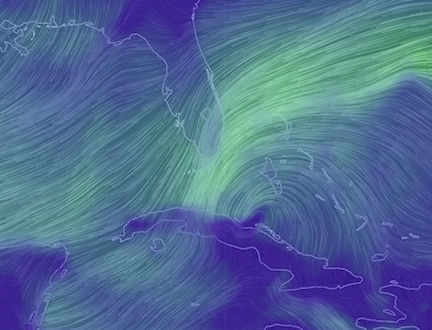
1. Shower and thunderstorm activity has increased since yesterday inLargoFL wrote:lets keep an eye on this one..until it passes florida going NW..
association with a broad area of low pressure located about 350
miles east of the northern Leeward Islands. Upper-level winds are
not expected to be conducive for significant development during the
next couple of days while the system moves west-northwestward at 15
to 20 mph and passes north of the Leeward Islands and the Virgin
Islands. However, environmental conditions could become a little
more conducive for some development early next week while the system
begins to move northward over the west-central Atlantic Ocean.
* Formation chance through 48 hours...low...10 percent.
* Formation chance through 5 days...low...30 percent.
Forecaster Brennan
LargoFL- Posts : 10724
Reputation : 130
Join date : 2017-03-05
Re: CLOSED 9-17-17 FLORIDA/ALABAMA BLOG
![]() by LargoFL Fri Oct 13, 2017 11:38 am
by LargoFL Fri Oct 13, 2017 11:38 am
.NOW...
Scattered showers, and potentially a few thunderstorms will develop
over the Atlantic waters. This activity will move west to southwest
up to 20 to 25 mph, moving onshore and inland across east central
Florida through early afternoon. The greatest coverage of showers
will be across Brevard County and the Treasure Coast, with the
potential for some locally heavy rainfall up to around an inch
across this region. Otherwise, most showers will only produce brief
periods of light to moderate rainfall.
Main threats from any showers or storms will be gusty winds up to 30
to 35 mph and occasional lightning strikes as they push onshore and
inland.
&&
Additional details...including graphics are available online at:
http://www.weather.gov/mlb/blog
$$
Weitlich
LargoFL- Posts : 10724
Reputation : 130
Join date : 2017-03-05
Re: CLOSED 9-17-17 FLORIDA/ALABAMA BLOG
![]() by LargoFL Fri Oct 13, 2017 12:10 pm
by LargoFL Fri Oct 13, 2017 12:10 pm
secondary wind surge will advect southwestward into southeast
Georgia this afternoon. This feature should generate widely
scattered showers and perhaps an embedded thunderstorm or two.
Isolated light showers will continue to move quickly onshore from
St. Augustine southward and into the St. Johns River basin this
afternoon. Otherwise, a ribbon of dry air will reside along the
Interstate 10 corridor, which will will negate rain chances today
for most of northeast Florida. Highs will climb into the upper 80s
inland, with low to mid 80s at the coast. Breezy east-
northeasterly winds will continue for locations east of I-95
overnight, with isolated to widely scattered showers possibly
advecting onshore into the coastal counties, mainly after
midnight. The deeper onshore wind regime will keep inland
temperatures warmer, with upper 60s to near 70 forecast, while
coastal lows remain in the mid to upper 70s.
&&
LargoFL- Posts : 10724
Reputation : 130
Join date : 2017-03-05
Re: CLOSED 9-17-17 FLORIDA/ALABAMA BLOG
![]() by LargoFL Fri Oct 13, 2017 12:16 pm
by LargoFL Fri Oct 13, 2017 12:16 pm
LargoFL- Posts : 10724
Reputation : 130
Join date : 2017-03-05
Re: CLOSED 9-17-17 FLORIDA/ALABAMA BLOG
![]() by LargoFL Fri Oct 13, 2017 12:16 pm
by LargoFL Fri Oct 13, 2017 12:16 pm
LargoFL- Posts : 10724
Reputation : 130
Join date : 2017-03-05
Re: CLOSED 9-17-17 FLORIDA/ALABAMA BLOG
![]() by LargoFL Fri Oct 13, 2017 2:20 pm
by LargoFL Fri Oct 13, 2017 2:20 pm
cooler and drier weather pattern will prevail through the long
term period as a strong area of high pressure builds over the
region. Rain chances will be rather low (generally 20 percent or
less through the period, and mainly near the coast). Temperatures
quite a bit cooler, with highs mainly in the 70s Monday through
Wednesday and around 80 by Thursday. Lows Monday night will
likely range from the lower 50s northwestern zones to the low/mid
60s coastal and extreme southeastern zones. Overnight lows
slightly moderate Tuesday and Wednesday nights, ranging from mid
50s inland to lower 60s at the coast. 12/DS
LargoFL- Posts : 10724
Reputation : 130
Join date : 2017-03-05
Re: CLOSED 9-17-17 FLORIDA/ALABAMA BLOG
![]() by LargoFL Fri Oct 13, 2017 2:21 pm
by LargoFL Fri Oct 13, 2017 2:21 pm
LargoFL- Posts : 10724
Reputation : 130
Join date : 2017-03-05
Re: CLOSED 9-17-17 FLORIDA/ALABAMA BLOG
![]() by LargoFL Fri Oct 13, 2017 2:27 pm
by LargoFL Fri Oct 13, 2017 2:27 pm
A large scale pattern change is expected to occur during this
period as an upper level trough moves southeastward across the
central and eastern CONUS on Monday and Tuesday. A cold front will
move through our area from northwest to southeast on Monday, and
in the wake of this feature significantly cooler temperatures are
expected to develop across our area. From Tuesday through the
remainder of the week, highs will range from the upper 70s to
lower 80s with lows generally from the upper 50s to lower 60s.
After low-end chances of showers and isolated thunderstorms on
Monday with the frontal passage, mainly dry conditions are
expected through the rest of the week as high pressure builds
across our area.
LargoFL- Posts : 10724
Reputation : 130
Join date : 2017-03-05
Re: CLOSED 9-17-17 FLORIDA/ALABAMA BLOG
![]() by BillsfaninSoFla Fri Oct 13, 2017 4:24 pm
by BillsfaninSoFla Fri Oct 13, 2017 4:24 pm
It turned out to be a nice (although very hot) day.
BillsfaninSoFla- Posts : 1966
Reputation : 52
Join date : 2017-03-05
Re: CLOSED 9-17-17 FLORIDA/ALABAMA BLOG
![]() by LargoFL Fri Oct 13, 2017 4:27 pm
by LargoFL Fri Oct 13, 2017 4:27 pm
that's good billsfan hope you could get some work done..was hot and sunny here till about 3 30pm and I got a half hour down pouring rain at Last!!..everything is wet again here..im a happy camper lolBillsfaninSoFla wrote:Thanks for the updates Largo.
It turned out to be a nice (although very hot) day.
LargoFL- Posts : 10724
Reputation : 130
Join date : 2017-03-05
Re: CLOSED 9-17-17 FLORIDA/ALABAMA BLOG
![]() by LargoFL Fri Oct 13, 2017 4:31 pm
by LargoFL Fri Oct 13, 2017 4:31 pm

LargoFL- Posts : 10724
Reputation : 130
Join date : 2017-03-05
Re: CLOSED 9-17-17 FLORIDA/ALABAMA BLOG
![]() by LargoFL Sat Oct 14, 2017 5:09 am
by LargoFL Sat Oct 14, 2017 5:09 am
LargoFL- Posts : 10724
Reputation : 130
Join date : 2017-03-05
Re: CLOSED 9-17-17 FLORIDA/ALABAMA BLOG
![]() by StAugustineFL Sat Oct 14, 2017 8:57 am
by StAugustineFL Sat Oct 14, 2017 8:57 am
StAugustineFL- Posts : 2231
Reputation : 64
Join date : 2012-07-17
Re: CLOSED 9-17-17 FLORIDA/ALABAMA BLOG
![]() by BillsfaninSoFla Sat Oct 14, 2017 1:40 pm
by BillsfaninSoFla Sat Oct 14, 2017 1:40 pm
We ran errands today, hit a bunch of rain south of us...
BillsfaninSoFla- Posts : 1966
Reputation : 52
Join date : 2017-03-05
Re: CLOSED 9-17-17 FLORIDA/ALABAMA BLOG
![]() by StAugustineFL Sat Oct 14, 2017 2:00 pm
by StAugustineFL Sat Oct 14, 2017 2:00 pm
BillsfaninSoFla wrote:Sounds great Aug. I can't wait until we get that first fall like day.
We ran errands today, hit a bunch of rain south of us...
Saw this earlier on the interwebs......

StAugustineFL- Posts : 2231
Reputation : 64
Join date : 2012-07-17
Re: CLOSED 9-17-17 FLORIDA/ALABAMA BLOG
![]() by StAugustineFL Sat Oct 14, 2017 2:02 pm
by StAugustineFL Sat Oct 14, 2017 2:02 pm

StAugustineFL- Posts : 2231
Reputation : 64
Join date : 2012-07-17
Re: CLOSED 9-17-17 FLORIDA/ALABAMA BLOG
![]() by LargoFL Sat Oct 14, 2017 2:23 pm
by LargoFL Sat Oct 14, 2017 2:23 pm

LargoFL- Posts : 10724
Reputation : 130
Join date : 2017-03-05
Re: CLOSED 9-17-17 FLORIDA/ALABAMA BLOG
![]() by LargoFL Sat Oct 14, 2017 2:24 pm
by LargoFL Sat Oct 14, 2017 2:24 pm
LargoFL- Posts : 10724
Reputation : 130
Join date : 2017-03-05
Re: CLOSED 9-17-17 FLORIDA/ALABAMA BLOG
![]() by JRnOldsmar Sat Oct 14, 2017 3:56 pm
by JRnOldsmar Sat Oct 14, 2017 3:56 pm
LargoFL wrote:some good rain coming Your way in awhile JR..good luck up there.............
Thanks, Largo. A good 1/2" over 2 days -- small fast showers. Good enough for the week, as long as the sun doesn't come out a-blazin' in the next few days.
Nice temps Aug and of course Gomey. Hopefully our forecast verifies. 86-87/70 later in the week. Those will be some nice mornings. I sure hope the 90's are gone for a while, and the 60's start popping up.

JRnOldsmar- Posts : 828
Reputation : 48
Join date : 2017-03-05
Location : Oldsmar, FL
Re: CLOSED 9-17-17 FLORIDA/ALABAMA BLOG
![]() by LargoFL Sat Oct 14, 2017 5:34 pm
by LargoFL Sat Oct 14, 2017 5:34 pm
yeah I got .20 in the last 24 hours..guess they lose their energy coming across the state...got a real fast sprinkle here a few hours ago..suns back out and man it sure is Humid here whew...lets see what tomorrow brings,rain wise as that wave crosses the state..should be over by Monday they think....I cannot wait..for high temps to be in the 70's again LOL..this summer sure was a Hot one huh.JRnOldsmar wrote:LargoFL wrote:some good rain coming Your way in awhile JR..good luck up there.............
Thanks, Largo. A good 1/2" over 2 days -- small fast showers. Good enough for the week, as long as the sun doesn't come out a-blazin' in the next few days.
Nice temps Aug and of course Gomey. Hopefully our forecast verifies. 86-87/70 later in the week. Those will be some nice mornings. I sure hope the 90's are gone for a while, and the 60's start popping up.
LargoFL- Posts : 10724
Reputation : 130
Join date : 2017-03-05
Re: CLOSED 9-17-17 FLORIDA/ALABAMA BLOG
![]() by LargoFL Sat Oct 14, 2017 5:36 pm
by LargoFL Sat Oct 14, 2017 5:36 pm
LargoFL- Posts : 10724
Reputation : 130
Join date : 2017-03-05

LargoFL- Posts : 10724
Reputation : 130
Join date : 2017-03-05
Re: CLOSED 9-17-17 FLORIDA/ALABAMA BLOG
![]() by LargoFL Sun Oct 15, 2017 6:09 am
by LargoFL Sun Oct 15, 2017 6:09 am
LargoFL- Posts : 10724
Reputation : 130
Join date : 2017-03-05
Re: CLOSED 9-17-17 FLORIDA/ALABAMA BLOG
![]() by StAugustineFL Sun Oct 15, 2017 8:01 am
by StAugustineFL Sun Oct 15, 2017 8:01 am
Looks like Tuesday into Wednesday will be quite wet here with 1-2" in the forecast.
StAugustineFL- Posts : 2231
Reputation : 64
Join date : 2012-07-17
Re: CLOSED 9-17-17 FLORIDA/ALABAMA BLOG
![]() by StAugustineFL Sun Oct 15, 2017 8:10 am
by StAugustineFL Sun Oct 15, 2017 8:10 am


StAugustineFL- Posts : 2231
Reputation : 64
Join date : 2012-07-17
Re: CLOSED 9-17-17 FLORIDA/ALABAMA BLOG
![]() by LargoFL Sun Oct 15, 2017 9:16 am
by LargoFL Sun Oct 15, 2017 9:16 am
good morning Aug,yeah you may get some heavier rain from the front,good luck, hope it drops your temps some..local met thinks it will fizzle out down here.StAugustineFL wrote:Good morning. Can we make it Saturday again? I'm not ready for the weekend to be over yet.
Looks like Tuesday into Wednesday will be quite wet here with 1-2" in the forecast.
LargoFL- Posts : 10724
Reputation : 130
Join date : 2017-03-05
Re: CLOSED 9-17-17 FLORIDA/ALABAMA BLOG
![]() by BillsfaninSoFla Sun Oct 15, 2017 12:52 pm
by BillsfaninSoFla Sun Oct 15, 2017 12:52 pm
No clouds at all today.
BillsfaninSoFla- Posts : 1966
Reputation : 52
Join date : 2017-03-05
Page 13 of 15 • 1 ... 8 ... 12, 13, 14, 15 ![]()
» CLOSED April - Florida/Alabama Blog
» CLOSED 4/2/17 Florida/Alabama Weather Blog
» CLOSED 5/29/17 Florida/Alabama Weather Blog
» CLOSED 1-6 Florida/Alabama Blog - January Thaw!
:: Florida Blog


» summer 2019 hurricane season
» April-May Florida weather and local events etc
» NASCAR 2019
» Late January through February outlook
» FLORIDA/ALABAMA AND THE HOLIDAY SEASON WEATHER
» NASCAR 2018
» CLOSED Florida/Alabama Blog - October Tropical Mischief