Latest topics
Warnings
Most Viewed Topics
Search
The Tropical Wave Train
+2
GrillinInTheEye
emcf30
6 posters
Page 1 of 1
 The Tropical Wave Train
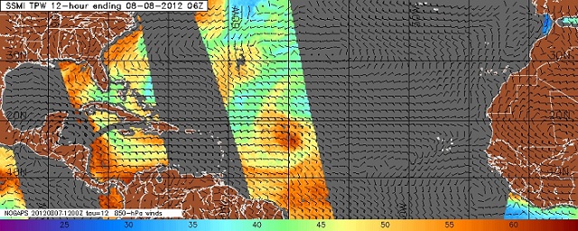
The World wide tropical zones are heating up.

Lets take a closer look at home.
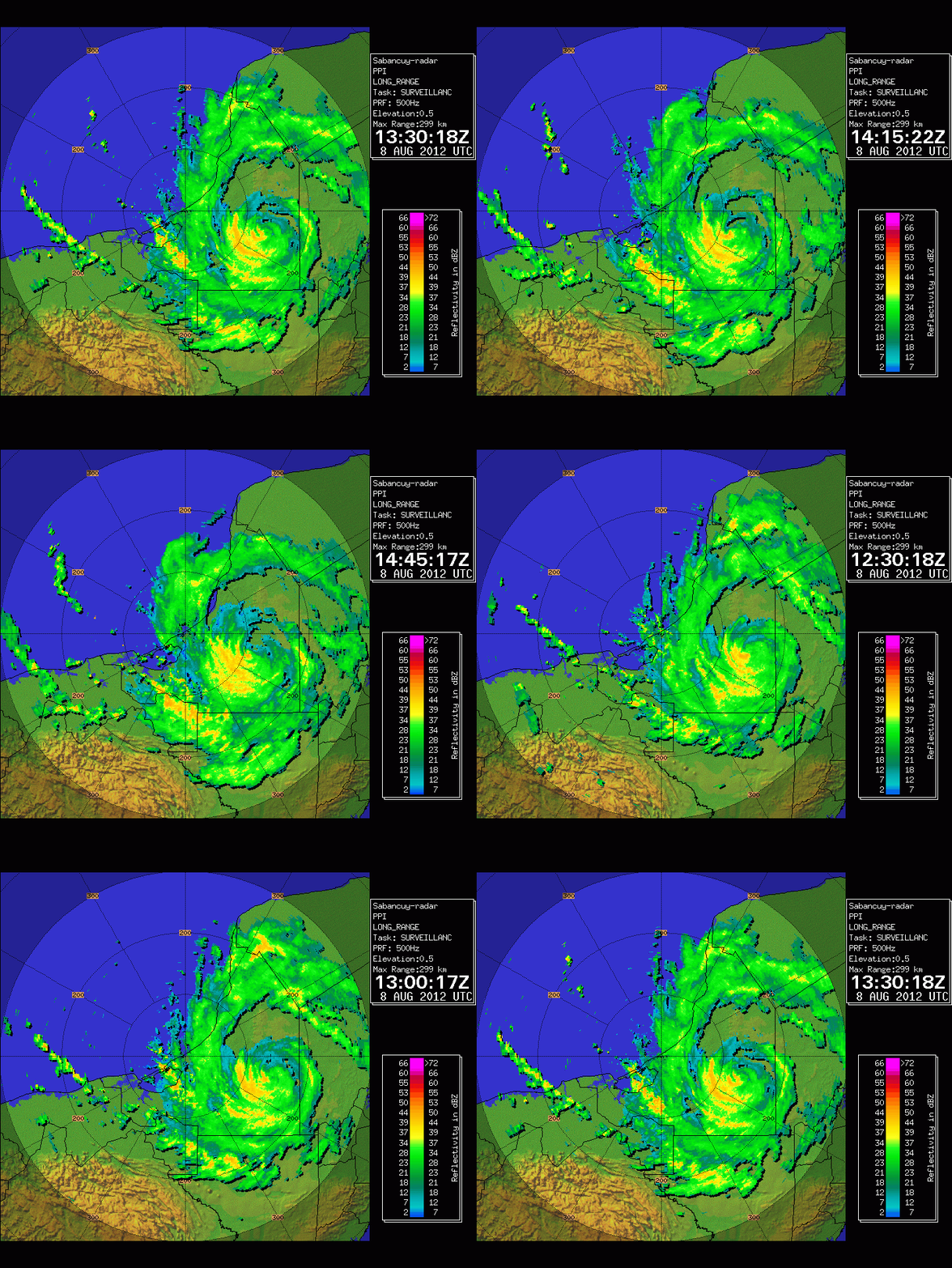
Hurricane Ernesto last night along the Southern coast of the Yucatan Peninsula near Mahahaul Mexico as a Category 1 Hurricane.
Here are the stats of the landfall by the NHC.

LOCATION...18.7N 87.7W
ABOUT 0 MI...0 KM E OF MAHAHUAL MEXICO
ABOUT 40 MI...65 KM ENE OF CHETUMAL MEXICO
MAXIMUM SUSTAINED WINDS...85 MPH...140 KM/H
PRESENT MOVEMENT...W OR 270 DEGREES AT 15 MPH...24 KM/H
MINIMUM CENTRAL PRESSURE...980 MB...28.94 INCHES
A Hurricane Hunter was en route to Ernesto prior to landfall but was plagued with equipment problems once again and was unable to transmit data to revel the true land falling pressure and wind-speed of Ernesto, but he did indeed put on a show.

At 04:00 hours Ernesto was downgraded to a Tropical Storm. He has done very well with his transition from sea to land and is making good headway across the Yucatan Peninsula.

Ernesto is expected to gain Hurricane status once again when he reaches the BOC later on today according to the NHC.

Elsewhere in the Tropical Atlantic

TROPICAL WEATHER OUTLOOK
NWS NATIONAL HURRICANE CENTER MIAMI FL
200 AM EDT WED AUG 8 2012
FOR THE NORTH ATLANTIC...CARIBBEAN SEA AND THE GULF OF MEXICO...
THE NATIONAL HURRICANE CENTER IS ISSUING ADVISORIES ON HURRICANE
ERNESTO...LOCATED ABOUT 20 MILES NORTH OF CHETUMAL MEXICO.
1. A SURFACE LOW PRESSURE SYSTEM ASSOCIATED WITH A TROPICAL WAVE
LOCATED ABOUT 700 MILES WEST-SOUTHWEST OF THE CAPE VERDE ISLANDS
HAS CHANGED LITTLE IN ORGANIZATION. ENVIRONMENTAL CONDITIONS ARE
MARGINALLY CONDUCIVE FOR GRADUAL DEVELOPMENT OVER THE NEXT COUPLE
OF DAYS. THIS SYSTEM HAS A MEDIUM CHANCE...30 PERCENT...OF BECOMING
A TROPICAL CYCLONE DURING THE NEXT 48 HOURS AS IT MOVES WESTWARD AT
10 TO 15 MPH.
2. SHOWER ACTIVITY HAS INCREASED IN ASSOCIATION WITH THE REMNANT LOW
OF FLORENCE LOCATED ABOUT 580 MILES EAST OF THE NORTHERN LEEWARD
ISLANDS. HOWEVER...UPPER-LEVEL WINDS ARE NOT EXPECTED TO BE
CONDUCIVE FOR REDEVELOPMENT...AND THIS SYSTEM HAS A LOW
CHANCE...NEAR 0 PERCENT...OF BECOMING A TROPICAL CYCLONE AGAIN
DURING THE NEXT 48 HOURS AS IT MOVES WEST-NORTHWESTWARD AT ABOUT 20
MPH.
ELSEWHERE...TROPICAL CYCLONE FORMATION IS NOT EXPECTED DURING THE
NEXT 48 HOURS.
In four (4) days the GFS shows 92l, as a small closed off low, tropical depression located over the Windward Islands and the African Blob starting to crank it up in the Eastern Atlantic.
CLICK to Animate pics below because I am to lazy to make an animation this morning.

The blob in question is looking very well this morning over land.

http://raleighwx.americanwx.com/models/gfs/06zgfs500mbHGHTPMSLtropicalGFSLoop.html
The blob currently over Africa may create some problems down the road. The models have developed this system for days now. We will see if the trend continues. Expect things to get crazy. Who in the hell said this was going to be a slow Cape Verde Season. Whom ever it was, may be proven wrong. But then again, maybe not.
Video from 28storms
Last edited by emcf30 on Thu Aug 09, 2012 1:42 pm; edited 4 times in total

emcf30- Posts : 975
Reputation : 10
Join date : 2012-07-16
Age : 93
 Re: The Tropical Wave Train
Thanks for the update E. You've been busy this morning. I know it's early but any thoughts on 92L?

GrillinInTheEye- Posts : 153
Reputation : 1
Join date : 2012-07-17
Age : 56
 Re: The Tropical Wave Train
GrillinInTheEye wrote:Thanks for the update E. You've been busy this morning. I know it's early but any thoughts on 92L?
Thanks Grill.
Have not dove to much into it yet but I believe it will move into the Caribbean similar to what Ernesto did. 92L is going to be moving through a area of strong wind shear ahead of it so don't expect any crazy development as it moves into that area of shear. But after that, I have not looked at it.
Look at the shear in the Windward Islands at the 96 hour mark. ( All the nice looking bright colors are NOT good )
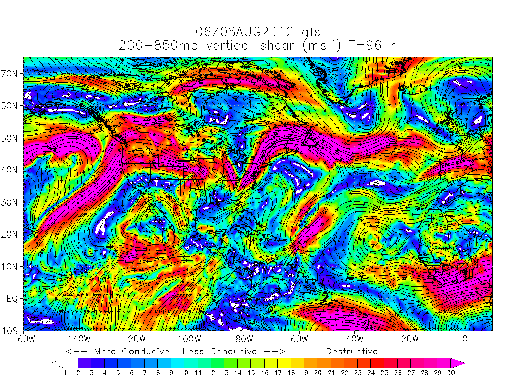
But, the Early cycle track guidance and the Early cycle intensity guidance indicate otherwise. I am not betting against the shear at the moment.


emcf30- Posts : 975
Reputation : 10
Join date : 2012-07-16
Age : 93
 Re: The Tropical Wave Train
Thanks e!! The wave train keeps a comin.....  92L looks a bit disheveled this morning!! Waiting for the be "big un" to come off the coast!!
Will it come off as a TD?
 92L looks a bit disheveled this morning!! Waiting for the be "big un" to come off the coast!!
 Will it come off as a TD?

sangria- Admin
- Posts : 2345
Reputation : 55
Join date : 2012-07-16
 Re: The Tropical Wave Train
Thanks e! Better get your rest while you can. It's "All Aboard" time. 

Tropic Bunker- Posts : 70
Reputation : 1
Join date : 2012-07-16
Age : 86
Location : Miami
 Re: The Tropical Wave Train
I just can't help, but to be impressed by the cloud tops on the next wave.....the last frame.....


sangria- Admin
- Posts : 2345
Reputation : 55
Join date : 2012-07-16
 Re: The Tropical Wave Train
One would have to think if Ernesto will even make it fully back over water based on its current track


Just sayin


Just sayin

emcf30- Posts : 975
Reputation : 10
Join date : 2012-07-16
Age : 93
 Re: The Tropical Wave Train
Thanks for the update E. Great job as usual. BTW, I do not like the model run in your first comment, please remove it. 
Just wait, it gets better.

We all may have to haul ass to San's house

Just wait, it gets better.

We all may have to haul ass to San's house

scouter534- Posts : 128
Reputation : 1
Join date : 2012-07-16
Age : 63
Location : Pompano Beach, FL
 Re: The Tropical Wave Train
Please make an advance reservation on e's arc, for pick- up........Package deal available for transport/accommodations.......

sangria- Admin
- Posts : 2345
Reputation : 55
Join date : 2012-07-16
 Re: The Tropical Wave Train
sangria wrote:Please make an advance reservation on e's arc, for pick- up........Package deal available for transport/accommodations.......
Please do, I got 3 suites left in the Harem Wing.

Plus, the pool is complete so if we sail before the cloud deck gets here you can take full advantage of the amenities.


emcf30- Posts : 975
Reputation : 10
Join date : 2012-07-16
Age : 93
 Re: The Tropical Wave Train
Nice Ark. That model comes true, we may need it.

scouter534- Posts : 128
Reputation : 1
Join date : 2012-07-16
Age : 63
Location : Pompano Beach, FL
 Re: The Tropical Wave Train
LMAO dude!!!

sangria- Admin
- Posts : 2345
Reputation : 55
Join date : 2012-07-16
 Re: The Tropical Wave Train
Just what I thought earlier this morning.

Not anticipated to make it that far off of land to re-strengthen at the moment.

Not anticipated to make it that far off of land to re-strengthen at the moment.

emcf30- Posts : 975
Reputation : 10
Join date : 2012-07-16
Age : 93
 Re: The Tropical Wave Train
Looks like it might just make it to the EPAC.....

Seawall- Posts : 125
Reputation : 3
Join date : 2012-07-16
 Re: The Tropical Wave Train
I wish this storm would make up it's mind. LOL

Now it looks like it is coming out further North


Now it looks like it is coming out further North


emcf30- Posts : 975
Reputation : 10
Join date : 2012-07-16
Age : 93
 Re: The Tropical Wave Train
Check this out. This is the FB page for Hurricane Josh from amwx. He went to Chase Ernest and is reporting back live information. He is one of my friends on FB. Here is his community page. Like it and check it out
https://www.facebook.com/iCyclone?ref=stream
https://www.facebook.com/iCyclone?ref=stream

emcf30- Posts : 975
Reputation : 10
Join date : 2012-07-16
Age : 93
 Re: The Tropical Wave Train
We have take off

Heading South to Ernesto


Heading South to Ernesto


emcf30- Posts : 975
Reputation : 10
Join date : 2012-07-16
Age : 93
 Re: The Tropical Wave Train
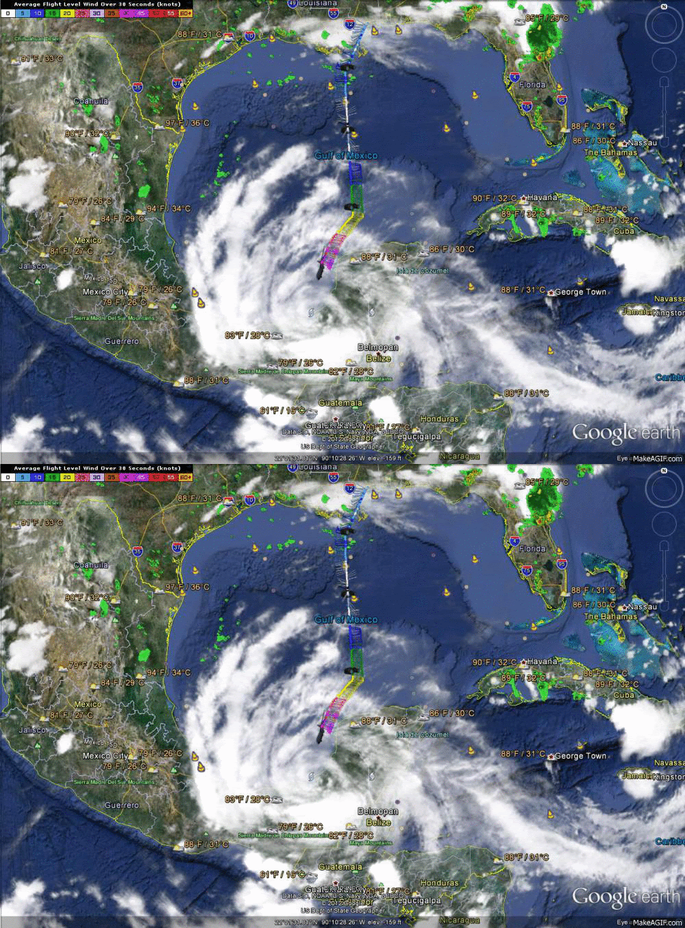
HH starting their decent into the center


emcf30- Posts : 975
Reputation : 10
Join date : 2012-07-16
Age : 93
 Re: The Tropical Wave Train
Look at the blow up of storms over Ernesto. HH hunters finding almost Hurricane strength again. Approaching 65 mph at surface, 80 @ flight.
Look at the difference in the cloud deck from the image above.

Look at the difference in the cloud deck from the image above.


emcf30- Posts : 975
Reputation : 10
Join date : 2012-07-16
Age : 93
 Similar topics
» The Atlantic Express - Tropical Storm Isaac - Tropical STorm Joyce- and New AOI
» Tropical Teaser?
» Tropical Storm Erika
» How does Gomey survive a Tropical Storm?
» Tropical Storm Hermine UPDATE 9/1/16
» Tropical Teaser?
» Tropical Storm Erika
» How does Gomey survive a Tropical Storm?
» Tropical Storm Hermine UPDATE 9/1/16
Page 1 of 1
Permissions in this forum:
You cannot reply to topics in this forum








» summer 2019 hurricane season
» April-May Florida weather and local events etc
» NASCAR 2019
» Late January through February outlook
» FLORIDA/ALABAMA AND THE HOLIDAY SEASON WEATHER
» NASCAR 2018
» CLOSED Florida/Alabama Blog - October Tropical Mischief