


CLOSED Beginning of 2018 Tropical Season for Florida
:: Florida Blog
Page 12 of 16 •  1 ... 7 ... 11, 12, 13, 14, 15, 16
 ![]()
Re: CLOSED Beginning of 2018 Tropical Season for Florida
![]() by LargoFL Sun Jun 10, 2018 2:01 pm
by LargoFL Sun Jun 10, 2018 2:01 pm
LOL 5 and 7 years old my grand kidssangria wrote:LargoFL wrote:good morning Billsfan, she and her family have been here all week, they go home tuesday,most of this week they and my wife have been over at Disney world..they got back here last night..me and the dogs had a very ..hmmm restful week LOLBillsfaninSoFla wrote:Morning everyone!
Largo- when does your daughter arrive?
Bwahahahaha at "restful" Largo!

LargoFL- Posts : 10724
Reputation : 130
Join date : 2017-03-05
Re: CLOSED Beginning of 2018 Tropical Season for Florida
![]() by LargoFL Sun Jun 10, 2018 2:05 pm
by LargoFL Sun Jun 10, 2018 2:05 pm
I think Tropical tidbits added the ICON model to its Global model section just this year if i remember right..ive been waiting for the season to begin so i can see how reliable it is.StAugustineFL wrote:Is the ICON model something new? I've not heard of it before
ECSB is slowly making it's way to the I-95 corridor. Some storms popping along it at the coast.
LargoFL- Posts : 10724
Reputation : 130
Join date : 2017-03-05
Re: CLOSED Beginning of 2018 Tropical Season for Florida
![]() by LargoFL Sun Jun 10, 2018 2:06 pm
by LargoFL Sun Jun 10, 2018 2:06 pm
LargoFL- Posts : 10724
Reputation : 130
Join date : 2017-03-05
Re: CLOSED Beginning of 2018 Tropical Season for Florida
![]() by LargoFL Sun Jun 10, 2018 2:15 pm
by LargoFL Sun Jun 10, 2018 2:15 pm
National Weather Service Jacksonville FL
210 PM EDT SUN JUN 10 2018
FLZ036-101900-
Alachua FL-
210 PM EDT SUN JUN 10 2018
...SIGNIFICANT WEATHER ADVISORY FOR SOUTHWESTERN ALACHUA COUNTY UNTIL
300 PM EDT...
At 210 PM EDT, Doppler radar was tracking a strong thunderstorm 9
miles northwest of Archer, or 14 miles east of Trenton, moving east
at 10 mph.
Nickel size hail and wind gusts of 45 to 55 mph can be expected along
with possible minor damage.
Locations impacted include...
Gainesville, Alachua, Archer, University Of Florida and Newberry.
PRECAUTIONARY/PREPAREDNESS ACTIONS...
Torrential rainfall is also occurring with this storm, and may lead
to localized flooding. Do not drive your vehicle through flooded
roadways.
Frequent cloud to ground lightning is occurring with this storm.
Lightning can strike 10 miles away from a thunderstorm. Seek a safe
shelter inside a building or vehicle.
&&
LAT...LON 2955 8264 2973 8264 2982 8229 2950 8230
TIME...MOT...LOC 1810Z 270DEG 10KT 2965 8259
$$
HESS
LargoFL- Posts : 10724
Reputation : 130
Join date : 2017-03-05
Re: CLOSED Beginning of 2018 Tropical Season for Florida
![]() by LargoFL Sun Jun 10, 2018 2:16 pm
by LargoFL Sun Jun 10, 2018 2:16 pm
LargoFL- Posts : 10724
Reputation : 130
Join date : 2017-03-05

LargoFL- Posts : 10724
Reputation : 130
Join date : 2017-03-05
Re: CLOSED Beginning of 2018 Tropical Season for Florida
![]() by BillsfaninSoFla Sun Jun 10, 2018 3:00 pm
by BillsfaninSoFla Sun Jun 10, 2018 3:00 pm
BillsfaninSoFla- Posts : 1966
Reputation : 52
Join date : 2017-03-05
Re: CLOSED Beginning of 2018 Tropical Season for Florida
![]() by LargoFL Sun Jun 10, 2018 3:02 pm
by LargoFL Sun Jun 10, 2018 3:02 pm

LargoFL- Posts : 10724
Reputation : 130
Join date : 2017-03-05
Re: CLOSED Beginning of 2018 Tropical Season for Florida
![]() by LargoFL Sun Jun 10, 2018 3:22 pm
by LargoFL Sun Jun 10, 2018 3:22 pm
National Weather Service Jacksonville FL
302 PM EDT SUN JUN 10 2018
FLC109-102100-
/O.NEW.KJAX.FA.Y.0099.180610T1902Z-180610T2100Z/
/00000.N.ER.000000T0000Z.000000T0000Z.000000T0000Z.OO/
St. Johns FL-
302 PM EDT SUN JUN 10 2018
The National Weather Service in Jacksonville has issued a
* Flood Advisory for Minor Flooding in Poor Drainage Areas for...
Central St. Johns County in northeastern Florida...
* Until 500 PM EDT.
* At 301 PM EDT, Doppler radar indicated heavy rain due to
thunderstorms. This will cause minor flooding. Overflowing poor
drainage areas will result in minor flooding in the advisory area.
Up to two inches of rain have already fallen.
* Some locations that will experience flooding include...
Saint Augustine, World Golf Village, Vilano Beach and Bakersville.
Additional rainfall of around an inch is expected over the area.
This additional rain will result in minor flooding.
PRECAUTIONARY/PREPAREDNESS ACTIONS...
Turn around, don`t drown when encountering flooded roads. Most flood
deaths occur in vehicles.
Excessive runoff from heavy rainfall will cause flooding of small
creeks and streams, urban areas, highways, streets and underpasses as
well as other drainage areas and low lying spots.
&&
LAT...LON 2989 8151 3001 8152 3001 8131 2989 8130
$$
HESS
LargoFL- Posts : 10724
Reputation : 130
Join date : 2017-03-05
Re: CLOSED Beginning of 2018 Tropical Season for Florida
![]() by LargoFL Sun Jun 10, 2018 3:24 pm
by LargoFL Sun Jun 10, 2018 3:24 pm
National Weather Service Miami FL
252 PM EDT SUN JUN 10 2018
FLZ069-070-101930-
Coastal Collier County FL-Inland Collier County FL-
252 PM EDT SUN JUN 10 2018
...SIGNIFICANT WEATHER ADVISORY FOR WEST CENTRAL COLLIER COUNTY UNTIL
330 PM EDT...
* At 251 PM EDT, National Weather Service meteorologists were
tracking a strong thunderstorm over Golden Gate, or 7 miles east of
Naples, moving northeast at 5 mph.
* Small hail, excessive cloud-to-ground lightning, and winds in
excess of 45 mph will be possible with this storm.
* Locations impacted include...
Naples, Golden Gate Estates, Orangetree, West Toll Gate On
Alligator Alley, Vineyards, Golden Gate, North Naples, East Naples
and Quail Creek Estate.
PRECAUTIONARY/PREPAREDNESS ACTIONS...
Persons participating in outdoor activities should seek sturdy
shelter until this storm passes. Open shelters found in parks,
beaches, or golf courses offer no protection from the dangers of
lightning.
&&
LAT...LON 2632 8177 2632 8166 2635 8166 2634 8159
2624 8147 2610 8164 2615 8178
TIME...MOT...LOC 1851Z 208DEG 6KT 2616 8170
$$
MOLLEDA
LargoFL- Posts : 10724
Reputation : 130
Join date : 2017-03-05

LargoFL- Posts : 10724
Reputation : 130
Join date : 2017-03-05
Re: CLOSED Beginning of 2018 Tropical Season for Florida
![]() by sangria Sun Jun 10, 2018 3:36 pm
by sangria Sun Jun 10, 2018 3:36 pm
LargoFL wrote:and so next weekend we wait this out and see where it goes..eastward or westward..
Larry Cosgrove
There is at last decent numerical model agreement on a tropical disturbance now taking shape in the western Caribbean Sea. Following the ECMWF and GFS series, we will have a low pressure area, probably below depression strength, ride the eastern coastline of Mexico with the center coming into TX near Corpus Christi in about a week or so. This is not a hurricane risk but may provide beneficial, if not heavy, rains, across much of the Lone Star State on June 16 - 20. More later...

sangria- Admin
- Posts : 2345
Reputation : 55
Join date : 2012-07-16
Re: CLOSED Beginning of 2018 Tropical Season for Florida
![]() by LargoFL Sun Jun 10, 2018 5:06 pm
by LargoFL Sun Jun 10, 2018 5:06 pm
lol actually my dogs like..playing with the kids, especially catching the tennis ball etc,although at times they do hide under the table lolBillsfaninSoFla wrote:That's great Largo, 5/7, They have tons of energy at that age. I'm sure you and Mrs Largo are enjoying it, maybe not the dogs lol
Last edited by LargoFL on Sun Jun 10, 2018 5:08 pm; edited 1 time in total
LargoFL- Posts : 10724
Reputation : 130
Join date : 2017-03-05
Re: CLOSED Beginning of 2018 Tropical Season for Florida
![]() by LargoFL Sun Jun 10, 2018 5:07 pm
by LargoFL Sun Jun 10, 2018 5:07 pm
ok thanks for this, hope he is right,sangria wrote:LargoFL wrote:and so next weekend we wait this out and see where it goes..eastward or westward..
Larry Cosgrove
There is at last decent numerical model agreement on a tropical disturbance now taking shape in the western Caribbean Sea. Following the ECMWF and GFS series, we will have a low pressure area, probably below depression strength, ride the eastern coastline of Mexico with the center coming into TX near Corpus Christi in about a week or so. This is not a hurricane risk but may provide beneficial, if not heavy, rains, across much of the Lone Star State on June 16 - 20. More later...
LargoFL- Posts : 10724
Reputation : 130
Join date : 2017-03-05
Re: CLOSED Beginning of 2018 Tropical Season for Florida
![]() by BillsfaninSoFla Sun Jun 10, 2018 5:50 pm
by BillsfaninSoFla Sun Jun 10, 2018 5:50 pm
BillsfaninSoFla- Posts : 1966
Reputation : 52
Join date : 2017-03-05
Re: CLOSED Beginning of 2018 Tropical Season for Florida
![]() by LargoFL Mon Jun 11, 2018 5:20 am
by LargoFL Mon Jun 11, 2018 5:20 am
This Hazardous Weather Outlook is for West Central And Southwest
Florida.
.DAY ONE...Today and Tonight.
...THUNDERSTORM IMPACT...
Scattered thunderstorms can be expected today, with the greatest
potential for a passing storm over the interior parts of the
state...and down toward the Fort Myers region during the
afternoon and early evening hours. Thunderstorms that develop will
be capable of producing gusty winds...locally heavy rains...and
frequent deadly lightning strikes. A few strong storms are
possible...but widespread severe weather is not expected.
.DAYS TWO THROUGH SEVEN...Tuesday through Sunday.
...THUNDERSTORM IMPACT...
A scattering of typical summer thunderstorms are expected each day
through the week. Most of the storms will occur during the
afternoon and early evening hours and form across the interior
and southern portions of the region. Thunderstorms will be capable
of producing gusty winds...locally heavy rains... and frequent
deadly lightning strikes. A few strong storms are
possible any given day...but widespread severe weather is not
expected.
.SPOTTER INFORMATION STATEMENT...
Spotter activation will not be needed today.
$$
LargoFL- Posts : 10724
Reputation : 130
Join date : 2017-03-05
Re: CLOSED Beginning of 2018 Tropical Season for Florida
![]() by LargoFL Mon Jun 11, 2018 5:22 am
by LargoFL Mon Jun 11, 2018 5:22 am
...Scattered to Numerous Storms Across South Florida Again Today...
...A Few Strong Storms Possible Mainly Interior/West Coast This Afternoon...
...Waterspouts Possible Over the Local Atlantic This Morning...
This hazardous weather outlook is for South Florida.
.DAY ONE...TODAY AND TONIGHT
Thunderstorms: Scattered to numerous thunderstorms are expected
again across South Florida today. Activity is expected along the east
coast metro through the morning hours, with the highest coverage
once again across the interior and Gulf coast this afternoon and
evening. The primary threats are lightning, small hail, gusty winds,
and localized minor flooding.
Waterspouts: Conditions are favorable for the development of several
waterspouts over the nearshore Atlantic waters this morning, with
more isolated waterspouts possible over the remainder of the Atlantic
waters. Isolated waterspouts will be possible across the remainder
of the South Florida waters through the rest of the day.
Wind: The strongest thunderstorms will be capable of producing
strong wind gusts to around 60 mph, mainly across the interior and
Gulf coast with boundary collisions later today.
Hail: Dime to nickel sized is possible with the strongest storms
today, especially over the interior and west coast metro areas.
Flooding: Slow moving thunderstorms will bring the threat of minor
flooding of streets and poor drainage areas, especially for urban
locations across South Florida.
.DAYS TWO THROUGH SEVEN...TUESDAY THROUGH SUNDAY
Scattered thunderstorms are expected each day, generally along the
east coast during the overnight and morning hours, and across the
interior and Gulf coast during the afternoons and evenings. The
primary threat will be lightning, although gusty winds and locally
heavy rain are also possible.
.SPOTTER INFORMATION STATEMENT...
Widespread spotter activation is not anticipated, however individual
spotters are encouraged to report high wind, hail and flooding to
the National Weather Service forecast office in Miami.
For more information...visit the National Weather Service in
Miami website at www.weather.gov/miami.
$$
LargoFL- Posts : 10724
Reputation : 130
Join date : 2017-03-05
Re: CLOSED Beginning of 2018 Tropical Season for Florida
![]() by LargoFL Mon Jun 11, 2018 5:25 am
by LargoFL Mon Jun 11, 2018 5:25 am
LargoFL- Posts : 10724
Reputation : 130
Join date : 2017-03-05
Re: CLOSED Beginning of 2018 Tropical Season for Florida
![]() by LargoFL Mon Jun 11, 2018 6:40 am
by LargoFL Mon Jun 11, 2018 6:40 am
LargoFL- Posts : 10724
Reputation : 130
Join date : 2017-03-05
Re: CLOSED Beginning of 2018 Tropical Season for Florida
![]() by LargoFL Mon Jun 11, 2018 6:42 am
by LargoFL Mon Jun 11, 2018 6:42 am
LargoFL- Posts : 10724
Reputation : 130
Join date : 2017-03-05
LargoFL- Posts : 10724
Reputation : 130
Join date : 2017-03-05
Re: CLOSED Beginning of 2018 Tropical Season for Florida
![]() by severstorm Mon Jun 11, 2018 8:09 am
by severstorm Mon Jun 11, 2018 8:09 am
Was a hot and sunshine filled weekend. All the storms set up just to my east and went east.
No rain in the bucket all weekend. Grass is greener and growing fast.
Yep don't think we have to worry about south system.
So thanks for the coffee Largo!
Have a great day
John Z-hills
severstorm- Posts : 331
Reputation : 14
Join date : 2017-03-14
Age : 61
Location : Zephyrhills
Re: CLOSED Beginning of 2018 Tropical Season for Florida
![]() by LargoFL Mon Jun 11, 2018 8:53 am
by LargoFL Mon Jun 11, 2018 8:53 am
ok John..have a good day up there, yes im on my second cup!!severstorm wrote:Morning All,
Was a hot and sunshine filled weekend. All the storms set up just to my east and went east.
No rain in the bucket all weekend. Grass is greener and growing fast.
Yep don't think we have to worry about south system.
So thanks for the coffee Largo!
Have a great day
John Z-hills
LargoFL- Posts : 10724
Reputation : 130
Join date : 2017-03-05

LargoFL- Posts : 10724
Reputation : 130
Join date : 2017-03-05
Re: CLOSED Beginning of 2018 Tropical Season for Florida
![]() by BillsfaninSoFla Mon Jun 11, 2018 11:04 am
by BillsfaninSoFla Mon Jun 11, 2018 11:04 am
BillsfaninSoFla- Posts : 1966
Reputation : 52
Join date : 2017-03-05
Re: CLOSED Beginning of 2018 Tropical Season for Florida
![]() by JRnOldsmar Mon Jun 11, 2018 12:05 pm
by JRnOldsmar Mon Jun 11, 2018 12:05 pm
Largo: Hope you're having a great time with the grandkids in for a visit (even those restful periods).

JRnOldsmar- Posts : 828
Reputation : 48
Join date : 2017-03-05
Location : Oldsmar, FL
Re: CLOSED Beginning of 2018 Tropical Season for Florida
![]() by LargoFL Mon Jun 11, 2018 1:19 pm
by LargoFL Mon Jun 11, 2018 1:19 pm
hiya JR,yes just came back from the beach,whew is that sun HOT lol but the kids love the beach here...JRnOldsmar wrote:Regular summer westerly pattern remains in place. Storms build east and move east. No rain. Highs tracking near 90, but the breeze is helping the coastal areas stay near comfortable in the shade. This is why I put 3 oaks and a maple in the front yard. It's the "coolest" front yard in the neighborhood -- 90% shade by 2 or 3 in the afternoon. I don't see a pattern change (easterly flow) anytime this week.
Largo: Hope you're having a great time with the grandkids in for a visit (even those restful periods).
LargoFL- Posts : 10724
Reputation : 130
Join date : 2017-03-05
Re: CLOSED Beginning of 2018 Tropical Season for Florida
![]() by LargoFL Mon Jun 11, 2018 1:20 pm
by LargoFL Mon Jun 11, 2018 1:20 pm
National Weather Service Miami FL
1258 PM EDT MON JUN 11 2018
FLC099-111900-
/O.NEW.KMFL.FA.Y.0025.180611T1658Z-180611T1900Z/
/00000.N.ER.000000T0000Z.000000T0000Z.000000T0000Z.OO/
Palm Beach FL-
1258 PM EDT MON JUN 11 2018
The National Weather Service in Miami has issued a
* Flood Advisory for...
East central Palm Beach County in southeastern Florida...
* Until 300 PM EDT.
* At 1257 PM EDT, Doppler radar indicated heavy rain due to
thunderstorms. This will cause minor flooding in the advisory area.
Up to two and a half inches of rain have already fallen.
* Some locations that will experience flooding include...
West Palm Beach, Boynton Beach, Wellington, Lake Worth and
Greenacres.
Additional rainfall of one to two inches is expected over the area.
PRECAUTIONARY/PREPAREDNESS ACTIONS...
Turn around, don`t drown when encountering flooded roads. Most flood
deaths occur in vehicles.
&&
LAT...LON 2669 8006 2661 8007 2652 8008 2650 8022
2673 8021 2675 8009
$$
HAGEN
LargoFL- Posts : 10724
Reputation : 130
Join date : 2017-03-05
Re: CLOSED Beginning of 2018 Tropical Season for Florida
![]() by LargoFL Mon Jun 11, 2018 1:21 pm
by LargoFL Mon Jun 11, 2018 1:21 pm
National Weather Service Tallahassee FL
1252 PM EDT MON JUN 11 2018
FLZ028-111745-
Inland Taylor FL-
1252 PM EDT MON JUN 11 2018
...SIGNIFICANT WEATHER ADVISORY FOR NORTHWESTERN TAYLOR COUNTY
IN THE FLORIDA BIG BEND UNTIL 145 PM EDT...
At 1252 PM EDT, Doppler radar was tracking a strong thunderstorm 18
miles east of Woodville, moving east at 25 mph.
Wind gusts up to 50 mph will be possible with this storm.
Locations impacted include...
Perry, Lake Bird, Iddo, Secotan, Boyd, Perry-Foley Airport, Cabbage
Grove, Hampton Springs and Shady Grove.
&&
LAT...LON 3001 8360 3018 8395 3019 8394 3019 8393
3023 8392 3026 8389 3028 8384 3030 8382
3030 8347 3026 8347 3026 8346
TIME...MOT...LOC 1652Z 282DEG 22KT 3024 8390
$$
38-GODSEY
LargoFL- Posts : 10724
Reputation : 130
Join date : 2017-03-05
Re: CLOSED Beginning of 2018 Tropical Season for Florida
![]() by LargoFL Mon Jun 11, 2018 3:15 pm
by LargoFL Mon Jun 11, 2018 3:15 pm
National Weather Service Tampa Bay Area Ruskin FL
258 PM EDT MON JUN 11 2018
FLZ262-265-111945-
Inland Charlotte-Inland Lee-
258 PM EDT MON JUN 11 2018
...AN AREA OF STRONG THUNDERSTORMS WILL AFFECT SOUTH CENTRAL
CHARLOTTE AND NORTHEASTERN LEE COUNTIES...
At 257 PM EDT, strong thunderstorms were clustered near Buckingham,
or near Fort Myers, moving northeast at 15 mph.
Winds in excess of 30 mph and pea size hail are possible with
these storms.
Locations impacted include...
Fort Myers, Olga, Palmona Park, East Dunbar, Buckingham, Lochmoor
Waterway Estates, Tice, Fort Myers Shores, North Fort Myers, Gateway,
Alva and Suncoast Estates.
Torrential rainfall is also occurring with these storms, and may
cause localized flooding. Do not drive your vehicle through flooded
roadways.
Frequent cloud to ground lightning is occurring with these storms.
Lightning can strike 10 miles away from a thunderstorm. Seek a safe
shelter inside a building or vehicle.
LAT...LON 2656 8173 2665 8191 2684 8187 2676 8157
TIME...MOT...LOC 1857Z 210DEG 11KT 2668 8179
$$
TBW
LargoFL- Posts : 10724
Reputation : 130
Join date : 2017-03-05
Re: CLOSED Beginning of 2018 Tropical Season for Florida
![]() by LargoFL Mon Jun 11, 2018 3:17 pm
by LargoFL Mon Jun 11, 2018 3:17 pm
LargoFL- Posts : 10724
Reputation : 130
Join date : 2017-03-05

LargoFL- Posts : 10724
Reputation : 130
Join date : 2017-03-05
Re: CLOSED Beginning of 2018 Tropical Season for Florida
![]() by LargoFL Mon Jun 11, 2018 3:22 pm
by LargoFL Mon Jun 11, 2018 3:22 pm
TTAA00 KNHC DDHHMM
Tropical Weather Outlook
NWS National Hurricane Center Miami FL
200 PM EDT Mon Jun 11 2018
For the North Atlantic...Caribbean Sea and the Gulf of Mexico:
1. A broad area of showers and thunderstorms has persisted over the
southwestern Caribbean Sea for the past several hours. This activity
is associated with a tropical wave over northwestern Venezuela and
a surface trough located just east of Nicaragua interacting with a
large upper-level trough. Little development of this area of
disturbed weather is expected over the next few days due to
interaction with Central America and the Yucatan Peninsula. However,
environmental conditions could become somewhat more conducive for
some limited development when the system moves into the southwestern
Gulf of Mexico by the end of the week. Regardless of development,
this disturbance will produce locally heavy rainfall across portions
of Nicaragua, Honduras, Belize, Guatemala, and the Yucatan Peninsula
through Thursday.
* Formation chance through 48 hours...low...10 percent.
* Formation chance through 5 days...low...20 percent.
Forecaster Stewart
LargoFL- Posts : 10724
Reputation : 130
Join date : 2017-03-05

LargoFL- Posts : 10724
Reputation : 130
Join date : 2017-03-05
Re: CLOSED Beginning of 2018 Tropical Season for Florida
![]() by LargoFL Mon Jun 11, 2018 3:37 pm
by LargoFL Mon Jun 11, 2018 3:37 pm
LargoFL- Posts : 10724
Reputation : 130
Join date : 2017-03-05
Re: CLOSED Beginning of 2018 Tropical Season for Florida
![]() by StPeteFLwx Mon Jun 11, 2018 3:40 pm
by StPeteFLwx Mon Jun 11, 2018 3:40 pm
May 2018 Climate Summary
Miami to Key West, 11" above normal!
StPeteFLwx- Posts : 351
Reputation : 20
Join date : 2017-03-17
Re: CLOSED Beginning of 2018 Tropical Season for Florida
![]() by BillsfaninSoFla Mon Jun 11, 2018 3:44 pm
by BillsfaninSoFla Mon Jun 11, 2018 3:44 pm
I was probably 2-3 miles east of a hellacious storm
Thanks for updates everyone.
BillsfaninSoFla- Posts : 1966
Reputation : 52
Join date : 2017-03-05
Re: CLOSED Beginning of 2018 Tropical Season for Florida
![]() by StPeteFLwx Mon Jun 11, 2018 3:47 pm
by StPeteFLwx Mon Jun 11, 2018 3:47 pm
StPeteFLwx- Posts : 351
Reputation : 20
Join date : 2017-03-17
Re: CLOSED Beginning of 2018 Tropical Season for Florida
![]() by StAugustineFL Mon Jun 11, 2018 4:33 pm
by StAugustineFL Mon Jun 11, 2018 4:33 pm
I feel sorry for my neighbor. His roof was scheduled to be replaced last Thursday or Friday but with a 60% chance of rain he got rescheduled to today. It didn't rain but a hundredth of an inch or two those days. Roofers came today. 30% chance of rain and the skies opened up not once, but twice. My gauge looks to have around 1.25" but I won't have an official estimate til morning. Roofers left. I assume they'll be back at 6 - 6:30 tomorrow to finish the job.

StAugustineFL- Posts : 2231
Reputation : 64
Join date : 2012-07-17
Re: CLOSED Beginning of 2018 Tropical Season for Florida
![]() by BillsfaninSoFla Mon Jun 11, 2018 4:56 pm
by BillsfaninSoFla Mon Jun 11, 2018 4:56 pm
I'm st 80 percent tomorrow so I told a few people we'd hold off on work until Wednesday.
BillsfaninSoFla- Posts : 1966
Reputation : 52
Join date : 2017-03-05
Re: CLOSED Beginning of 2018 Tropical Season for Florida
![]() by LargoFL Mon Jun 11, 2018 7:09 pm
by LargoFL Mon Jun 11, 2018 7:09 pm
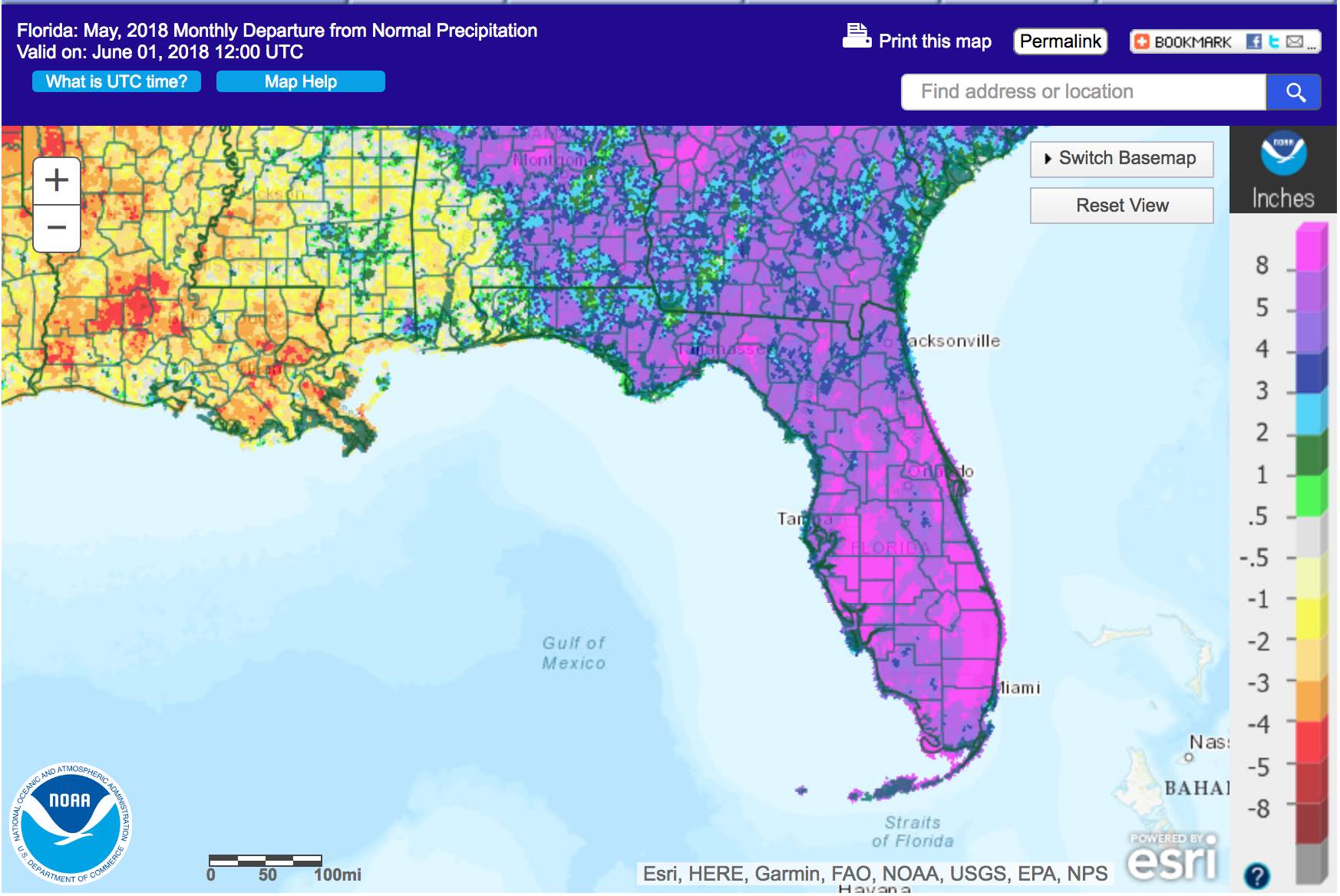
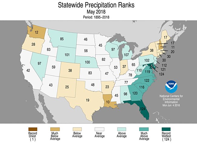
thanks for this st peteStPeteFLwx wrote:May summary from Florida Climate Center. Figure 1 pretty much covers it.
May 2018 Climate Summary
Miami to Key West, 11" above normal!
LargoFL- Posts : 10724
Reputation : 130
Join date : 2017-03-05

LargoFL- Posts : 10724
Reputation : 130
Join date : 2017-03-05
Re: CLOSED Beginning of 2018 Tropical Season for Florida
![]() by LargoFL Mon Jun 11, 2018 7:11 pm
by LargoFL Mon Jun 11, 2018 7:11 pm
LargoFL- Posts : 10724
Reputation : 130
Join date : 2017-03-05
Re: CLOSED Beginning of 2018 Tropical Season for Florida
![]() by LargoFL Mon Jun 11, 2018 7:15 pm
by LargoFL Mon Jun 11, 2018 7:15 pm
LargoFL- Posts : 10724
Reputation : 130
Join date : 2017-03-05
Re: CLOSED Beginning of 2018 Tropical Season for Florida
![]() by LargoFL Mon Jun 11, 2018 7:19 pm
by LargoFL Mon Jun 11, 2018 7:19 pm
LargoFL- Posts : 10724
Reputation : 130
Join date : 2017-03-05
Re: CLOSED Beginning of 2018 Tropical Season for Florida
![]() by BillsfaninSoFla Mon Jun 11, 2018 7:43 pm
by BillsfaninSoFla Mon Jun 11, 2018 7:43 pm
All quiet here too!
BillsfaninSoFla- Posts : 1966
Reputation : 52
Join date : 2017-03-05
Re: CLOSED Beginning of 2018 Tropical Season for Florida
![]() by BillsfaninSoFla Mon Jun 11, 2018 7:44 pm
by BillsfaninSoFla Mon Jun 11, 2018 7:44 pm
BillsfaninSoFla- Posts : 1966
Reputation : 52
Join date : 2017-03-05
Re: CLOSED Beginning of 2018 Tropical Season for Florida
![]() by LargoFL Tue Jun 12, 2018 4:59 am
by LargoFL Tue Jun 12, 2018 4:59 am
gee Lighning is sure scary huh..especially if your caught outdoors whew.BillsfaninSoFla wrote:A guy in Margate Florida got struck today too. NW Broward
LargoFL- Posts : 10724
Reputation : 130
Join date : 2017-03-05
Re: CLOSED Beginning of 2018 Tropical Season for Florida
![]() by LargoFL Tue Jun 12, 2018 4:59 am
by LargoFL Tue Jun 12, 2018 4:59 am
This Hazardous Weather Outlook is for West Central And Southwest
Florida.
.DAY ONE...Today and Tonight.
...THUNDERSTORM IMPACT...
Scattered thunderstorms can be expected today, with the greatest
potential for a passing storm over the interior parts of the
state...and down toward the Fort Myers region during the
afternoon and early evening hours. Thunderstorms that develop will
be capable of producing gusty winds...locally heavy rains...and
frequent deadly lightning strikes. A few strong storms are
possible...but widespread severe weather is not expected.
.DAYS TWO THROUGH SEVEN...Wednesday through Monday.
...THUNDERSTORM IMPACT...
A scattering of typical summer thunderstorms are expected each day
through the week. Most of the storms will occur during the
afternoon and early evening hours and form across the interior
and southern portions of the region. Thunderstorms will be capable
of producing gusty winds...locally heavy rains... and frequent
deadly lightning strikes. A few strong storms are
possible any given day...but widespread severe weather is not
expected.
.SPOTTER INFORMATION STATEMENT...
Spotter activation will not be needed today.
$$
Wynn
LargoFL- Posts : 10724
Reputation : 130
Join date : 2017-03-05
Page 12 of 16 • 1 ... 7 ... 11, 12, 13, 14, 15, 16 ![]()
» CLOSED 7-25 FLORIDA/ALABAMA Tropical season weather
» CLOSED Florida weather and Tropical season weather
» CLOSED FLORIDA/ALABAMA/TROPICAL BLOG
» CLOSED Florida/Alabama Fall Season weather
:: Florida Blog


» summer 2019 hurricane season
» April-May Florida weather and local events etc
» NASCAR 2019
» Late January through February outlook
» FLORIDA/ALABAMA AND THE HOLIDAY SEASON WEATHER
» NASCAR 2018
» CLOSED Florida/Alabama Blog - October Tropical Mischief