


CLOSED 9-17-17 FLORIDA/ALABAMA BLOG
:: Florida Blog
Page 11 of 15 •  1 ... 7 ... 10, 11, 12, 13, 14, 15
 ![]()
Re: CLOSED 9-17-17 FLORIDA/ALABAMA BLOG
![]() by BillsfaninSoFla Sat Oct 07, 2017 1:53 pm
by BillsfaninSoFla Sat Oct 07, 2017 1:53 pm
BillsfaninSoFla- Posts : 1966
Reputation : 52
Join date : 2017-03-05
Re: CLOSED 9-17-17 FLORIDA/ALABAMA BLOG
![]() by PuppyToes Sat Oct 07, 2017 2:27 pm
by PuppyToes Sat Oct 07, 2017 2:27 pm

PuppyToes- Posts : 185
Reputation : 4
Join date : 2017-03-28


LargoFL- Posts : 10724
Reputation : 130
Join date : 2017-03-05
Re: CLOSED 9-17-17 FLORIDA/ALABAMA BLOG
![]() by LargoFL Sat Oct 07, 2017 2:56 pm
by LargoFL Sat Oct 07, 2017 2:56 pm
LargoFL- Posts : 10724
Reputation : 130
Join date : 2017-03-05
Re: CLOSED 9-17-17 FLORIDA/ALABAMA BLOG
![]() by LargoFL Sat Oct 07, 2017 2:58 pm
by LargoFL Sat Oct 07, 2017 2:58 pm
LargoFL- Posts : 10724
Reputation : 130
Join date : 2017-03-05
Re: CLOSED 9-17-17 FLORIDA/ALABAMA BLOG
![]() by LargoFL Sat Oct 07, 2017 3:03 pm
by LargoFL Sat Oct 07, 2017 3:03 pm
LargoFL- Posts : 10724
Reputation : 130
Join date : 2017-03-05
Re: CLOSED 9-17-17 FLORIDA/ALABAMA BLOG
![]() by LargoFL Sat Oct 07, 2017 3:05 pm
by LargoFL Sat Oct 07, 2017 3:05 pm
BULLETIN - EAS ACTIVATION REQUESTED
Tornado Warning
National Weather Service Mobile AL
146 PM CDT SAT OCT 7 2017
The National Weather Service in Mobile has issued a
* Tornado Warning for...
Southwestern Baldwin County in southwestern Alabama...
* Until 215 PM CDT
* At 146 PM CDT, a severe thunderstorm capable of producing a tornado
was located 5 miles south of Orange Beach, moving northwest at 35
mph.
HAZARD...Tornado.
SOURCE...Radar indicated rotation.
IMPACT...Flying debris will be dangerous to those caught without
shelter. Mobile homes will be damaged or destroyed.
Damage to roofs, windows, and vehicles will occur. Tree
damage is likely.
* This dangerous storm will be near...
Gulf Shores around 155 PM CDT.
Bon Secour around 205 PM CDT.
Magnolia Springs around 215 PM CDT.
PRECAUTIONARY/PREPAREDNESS ACTIONS...
TAKE COVER NOW! Move to a basement or an interior room on the lowest
floor of a sturdy building. Avoid windows. If you are outdoors, in a
mobile home, or in a vehicle, move to the closest substantial shelter
and protect yourself from flying debris.
&&
LAT...LON 3022 8785 3032 8802 3035 8799 3036 8797
3036 8798 3052 8782 3022 8749
TIME...MOT...LOC 1846Z 129DEG 31KT 3020 8762
TORNADO...RADAR INDICATED
HAIL...0.00IN
$$
LargoFL- Posts : 10724
Reputation : 130
Join date : 2017-03-05
Re: CLOSED 9-17-17 FLORIDA/ALABAMA BLOG
![]() by LargoFL Sat Oct 07, 2017 3:07 pm
by LargoFL Sat Oct 07, 2017 3:07 pm
LargoFL- Posts : 10724
Reputation : 130
Join date : 2017-03-05
Re: CLOSED 9-17-17 FLORIDA/ALABAMA BLOG
![]() by BillsfaninSoFla Sat Oct 07, 2017 4:17 pm
by BillsfaninSoFla Sat Oct 07, 2017 4:17 pm
BillsfaninSoFla- Posts : 1966
Reputation : 52
Join date : 2017-03-05
BillsfaninSoFla- Posts : 1966
Reputation : 52
Join date : 2017-03-05
Re: CLOSED 9-17-17 FLORIDA/ALABAMA BLOG
![]() by LargoFL Sun Oct 08, 2017 5:42 am
by LargoFL Sun Oct 08, 2017 5:42 am
LOl you guys were making me hungry LOLBillsfaninSoFla wrote:Thanks Largo.
LargoFL- Posts : 10724
Reputation : 130
Join date : 2017-03-05
Re: CLOSED 9-17-17 FLORIDA/ALABAMA BLOG
![]() by LargoFL Sun Oct 08, 2017 5:43 am
by LargoFL Sun Oct 08, 2017 5:43 am

LargoFL- Posts : 10724
Reputation : 130
Join date : 2017-03-05
Re: CLOSED 9-17-17 FLORIDA/ALABAMA BLOG
![]() by LargoFL Sun Oct 08, 2017 5:46 am
by LargoFL Sun Oct 08, 2017 5:46 am
LargoFL- Posts : 10724
Reputation : 130
Join date : 2017-03-05
Re: CLOSED 9-17-17 FLORIDA/ALABAMA BLOG
![]() by LargoFL Sun Oct 08, 2017 5:53 am
by LargoFL Sun Oct 08, 2017 5:53 am

LargoFL- Posts : 10724
Reputation : 130
Join date : 2017-03-05
Re: CLOSED 9-17-17 FLORIDA/ALABAMA BLOG
![]() by LargoFL Sun Oct 08, 2017 7:06 am
by LargoFL Sun Oct 08, 2017 7:06 am
LargoFL- Posts : 10724
Reputation : 130
Join date : 2017-03-05
Re: CLOSED 9-17-17 FLORIDA/ALABAMA BLOG
![]() by LargoFL Sun Oct 08, 2017 7:09 am
by LargoFL Sun Oct 08, 2017 7:09 am
LargoFL- Posts : 10724
Reputation : 130
Join date : 2017-03-05

LargoFL- Posts : 10724
Reputation : 130
Join date : 2017-03-05
Re: CLOSED 9-17-17 FLORIDA/ALABAMA BLOG
![]() by LargoFL Sun Oct 08, 2017 7:16 am
by LargoFL Sun Oct 08, 2017 7:16 am

LargoFL- Posts : 10724
Reputation : 130
Join date : 2017-03-05
Re: CLOSED 9-17-17 FLORIDA/ALABAMA BLOG
![]() by LargoFL Sun Oct 08, 2017 7:20 am
by LargoFL Sun Oct 08, 2017 7:20 am

LargoFL- Posts : 10724
Reputation : 130
Join date : 2017-03-05

LargoFL- Posts : 10724
Reputation : 130
Join date : 2017-03-05
Re: CLOSED 9-17-17 FLORIDA/ALABAMA BLOG
![]() by StAugustineFL Sun Oct 08, 2017 8:36 am
by StAugustineFL Sun Oct 08, 2017 8:36 am
Gonna be quite warm here today. 90 degrees with a coin-flip chance for afternoon rain.

StAugustineFL- Posts : 2231
Reputation : 64
Join date : 2012-07-17
Re: CLOSED 9-17-17 FLORIDA/ALABAMA BLOG
![]() by LargoFL Sun Oct 08, 2017 9:08 am
by LargoFL Sun Oct 08, 2017 9:08 am
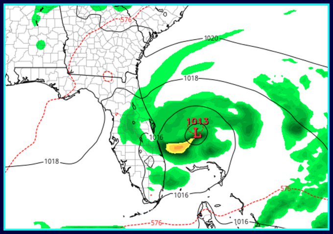
ok thanks Aug..hope he's ok...lots of folks without power up there news is saying.StAugustineFL wrote:Morning. Gomey may be in the dark. Looks like his area per some weather stations I was looking at had wind gusts of 60-70mph. His PWS had pressure bottoming out at 984MB.
Gonna be quite warm here today. 90 degrees with a coin-flip chance for afternoon rain.
LargoFL- Posts : 10724
Reputation : 130
Join date : 2017-03-05
Re: CLOSED 9-17-17 FLORIDA/ALABAMA BLOG
![]() by LargoFL Sun Oct 08, 2017 9:10 am
by LargoFL Sun Oct 08, 2017 9:10 am
LargoFL- Posts : 10724
Reputation : 130
Join date : 2017-03-05

LargoFL- Posts : 10724
Reputation : 130
Join date : 2017-03-05
Re: CLOSED 9-17-17 FLORIDA/ALABAMA BLOG
![]() by LargoFL Sun Oct 08, 2017 9:13 am
by LargoFL Sun Oct 08, 2017 9:13 am
Flood Warning
National Weather Service Mobile AL
537 AM CDT SUN OCT 8 2017
ALC003-035-053-099-FLC033-113-081630-
/O.NEW.KMOB.FA.W.0016.171008T1037Z-171008T1630Z/
/00000.0.ER.000000T0000Z.000000T0000Z.000000T0000Z.OO/
Monroe AL-Baldwin AL-Escambia AL-Conecuh AL-Santa Rosa FL-
Escambia FL-
537 AM CDT SUN OCT 8 2017
The National Weather Service in Mobile has issued a
* Flood Warning for...
South central Monroe County in south central Alabama...
Northeastern Baldwin County in southwestern Alabama...
Western Escambia County in south central Alabama...
Southwestern Conecuh County in south central Alabama...
Santa Rosa County in northwestern Florida...
Escambia County in northwestern Florida...
* Until 1130 AM CDT
* At 536 AM CDT, Doppler radar indicated thunderstorms have
produced heavy rain, which will cause flooding. Up to six inches
of rain have fallen.
* Some locations that will experience flooding include...
Pensacola, Ferry Pass, Brent, West Pensacola, Ensley, Warrington,
Gonzalez, Atmore, Pace, Milton, Gulf Breeze, Goulding, Century,
Flomaton, Bagdad, Myrtle Grove, McCullough, Oriole Beach, Navarre
and Molino.
LargoFL- Posts : 10724
Reputation : 130
Join date : 2017-03-05
Re: CLOSED 9-17-17 FLORIDA/ALABAMA BLOG
![]() by LargoFL Sun Oct 08, 2017 9:20 am
by LargoFL Sun Oct 08, 2017 9:20 am
LargoFL- Posts : 10724
Reputation : 130
Join date : 2017-03-05
Re: CLOSED 9-17-17 FLORIDA/ALABAMA BLOG
![]() by LargoFL Sun Oct 08, 2017 9:58 am
by LargoFL Sun Oct 08, 2017 9:58 am

LargoFL- Posts : 10724
Reputation : 130
Join date : 2017-03-05
Re: CLOSED 9-17-17 FLORIDA/ALABAMA BLOG
![]() by LargoFL Sun Oct 08, 2017 10:01 am
by LargoFL Sun Oct 08, 2017 10:01 am
LargoFL- Posts : 10724
Reputation : 130
Join date : 2017-03-05
Re: CLOSED 9-17-17 FLORIDA/ALABAMA BLOG
![]() by LargoFL Sun Oct 08, 2017 10:52 am
by LargoFL Sun Oct 08, 2017 10:52 am

LargoFL- Posts : 10724
Reputation : 130
Join date : 2017-03-05
Re: CLOSED 9-17-17 FLORIDA/ALABAMA BLOG
![]() by LargoFL Sun Oct 08, 2017 10:57 am
by LargoFL Sun Oct 08, 2017 10:57 am

LargoFL- Posts : 10724
Reputation : 130
Join date : 2017-03-05
Re: CLOSED 9-17-17 FLORIDA/ALABAMA BLOG
![]() by StAugustineFL Sun Oct 08, 2017 11:07 am
by StAugustineFL Sun Oct 08, 2017 11:07 am
StAugustineFL- Posts : 2231
Reputation : 64
Join date : 2012-07-17
Re: CLOSED 9-17-17 FLORIDA/ALABAMA BLOG
![]() by StAugustineFL Sun Oct 08, 2017 11:09 am
by StAugustineFL Sun Oct 08, 2017 11:09 am
Area Forecast Discussion
National Weather Service Jacksonville FL
955 AM EDT Sun Oct 8 2017
...High rain chances this afternoon...
.UPDATE...
TC Nate continues to progress northward quickly with center moving
through AL at this time. As a result of this system and high
pressure well to our east, deep southerly flow is over the area and
is seen in JAX sounding this morning. Very moist conditions with
PWATS of 2.19 inches observed and this is in agreement with satellite
derived value of 2.2 inches. Flow through 6 km is from about 180 deg
at 22 kt. Current visible imagery shows heating beginning over the
ern zones with our western zones in more of the cirrus outflow from
Nate. Low level cumulus is seen streaming quickly nwd over the FL
Big Bend and portions of Suwannee Valley and inland southeast
GA...with VAX vwp verifying 30-35 kt at 2000-3000 ft. Already seeing
some weak but notable development of cu here in the wrn zones and
this is where initial development of some convection is anticipated.
This convection will likely grow in intensity during the heating of
the day moving nwd quickly in the deep layer south flow...some of
which may be intense cells due to the high moisture and forecast
instability of about 3000 J/kg SBCAPE. Additional showers and storms
likely to form further east, as east coastal area winds back from
south to south-southeast (likely from east coast sea breeze
development) increasing low level convergence. There is some
potential for semi-organized convective clusters in north-south
lines due to shear values approaching 25-30 kt and some very heavy
rainfall with rates of 2-3 inches per hour possible. Gusty winds in
showers and storms due to water-loading and some pockets of drier
mid level air. Convection will press offshore this evening with a
gradual decrease in rainfall through midnight. Only minor changes to
the POP forecast at this time.
StAugustineFL- Posts : 2231
Reputation : 64
Join date : 2012-07-17
Re: CLOSED 9-17-17 FLORIDA/ALABAMA BLOG
![]() by LargoFL Sun Oct 08, 2017 11:19 am
by LargoFL Sun Oct 08, 2017 11:19 am
LargoFL- Posts : 10724
Reputation : 130
Join date : 2017-03-05
Re: CLOSED 9-17-17 FLORIDA/ALABAMA BLOG
![]() by BillsfaninSoFla Sun Oct 08, 2017 1:22 pm
by BillsfaninSoFla Sun Oct 08, 2017 1:22 pm
BillsfaninSoFla- Posts : 1966
Reputation : 52
Join date : 2017-03-05
Re: CLOSED 9-17-17 FLORIDA/ALABAMA BLOG
![]() by LargoFL Sun Oct 08, 2017 1:30 pm
by LargoFL Sun Oct 08, 2017 1:30 pm
lol Billsfan,now we are in the part of the season where the storms come in or close to Florida..wish we get no more whew.BillsfaninSoFla wrote:Hi everyone. I'm really tired of hurricane season. LOL
LargoFL- Posts : 10724
Reputation : 130
Join date : 2017-03-05
Re: CLOSED 9-17-17 FLORIDA/ALABAMA BLOG
![]() by LargoFL Sun Oct 08, 2017 1:30 pm
by LargoFL Sun Oct 08, 2017 1:30 pm

LargoFL- Posts : 10724
Reputation : 130
Join date : 2017-03-05
Re: CLOSED 9-17-17 FLORIDA/ALABAMA BLOG
![]() by PuppyToes Sun Oct 08, 2017 1:32 pm
by PuppyToes Sun Oct 08, 2017 1:32 pm

PuppyToes- Posts : 185
Reputation : 4
Join date : 2017-03-28
Re: CLOSED 9-17-17 FLORIDA/ALABAMA BLOG
![]() by LargoFL Sun Oct 08, 2017 1:33 pm
by LargoFL Sun Oct 08, 2017 1:33 pm

LargoFL- Posts : 10724
Reputation : 130
Join date : 2017-03-05
Re: CLOSED 9-17-17 FLORIDA/ALABAMA BLOG
![]() by LargoFL Sun Oct 08, 2017 1:34 pm
by LargoFL Sun Oct 08, 2017 1:34 pm
LargoFL- Posts : 10724
Reputation : 130
Join date : 2017-03-05
Re: CLOSED 9-17-17 FLORIDA/ALABAMA BLOG
![]() by StAugustineFL Sun Oct 08, 2017 2:06 pm
by StAugustineFL Sun Oct 08, 2017 2:06 pm
StAugustineFL- Posts : 2231
Reputation : 64
Join date : 2012-07-17
Re: CLOSED 9-17-17 FLORIDA/ALABAMA BLOG
![]() by JRnOldsmar Sun Oct 08, 2017 2:45 pm
by JRnOldsmar Sun Oct 08, 2017 2:45 pm
PuppyToes wrote:You sure do have that right! But I wouldn’t mind a good shower. We keep getting missed
Same here, PT. 4 straight days of 50-90% POPs.....and nothin'. Last chance is off the coast, and not looking promising...

JRnOldsmar- Posts : 828
Reputation : 48
Join date : 2017-03-05
Location : Oldsmar, FL

LargoFL- Posts : 10724
Reputation : 130
Join date : 2017-03-05
Re: CLOSED 9-17-17 FLORIDA/ALABAMA BLOG
![]() by LargoFL Sun Oct 08, 2017 4:32 pm
by LargoFL Sun Oct 08, 2017 4:32 pm
LargoFL- Posts : 10724
Reputation : 130
Join date : 2017-03-05
Re: CLOSED 9-17-17 FLORIDA/ALABAMA BLOG
![]() by LargoFL Sun Oct 08, 2017 4:45 pm
by LargoFL Sun Oct 08, 2017 4:45 pm
WEDNESDAY NIGHT THROUGH NEXT WEEKEND: A mid to upper level low
should approach the region from the east late Wednesday and
Thursday. Models diverge as to whether the low reaches as far west
as South Florida by late week, or whether it stays east of
Florida. A tropical wave could also be approaching from the east
late in the week. There is quite a bit of uncertainty among the
various global models in atmospheric moisture levels for Friday
into next weekend based on the track and development of the upper
low and the wave. The ECMWF continues to bring a weak trough over
the area while the GFS doesn`t quite bring the higher moisture
through South Florida. For now, I have opted to keep PoPs below 50
percent for Friday and Saturday, but this will need to be
revisited in later forecasts as forecast confidence increases.
LargoFL- Posts : 10724
Reputation : 130
Join date : 2017-03-05
Re: CLOSED 9-17-17 FLORIDA/ALABAMA BLOG
![]() by LargoFL Sun Oct 08, 2017 4:49 pm
by LargoFL Sun Oct 08, 2017 4:49 pm
retrograde toward LA into late week with an upper low/TUTT moving
westward and slowing just east of the state. Favor the ECM solution
which shows an inverted surface trough approaching the southern half
of Florida by Friday morning, then continuing westward across the
state and into the SE GOMEX this weekend. Mid level moisture will
remain rather limited through Thursday, keeping low shower chances
(20-30) in place. From Friday into the upcoming weekend, increasing
moisture/convergence will advect onshore, with higher prospects for
showers and storms. Have raised POPs toward the much higher ECM
numbers, though for now, we remain about 10-20 percent below them.
Highs mid 80s coast and upper 80s-90F inland Lows in the 70s.
&&
LargoFL- Posts : 10724
Reputation : 130
Join date : 2017-03-05
Re: CLOSED 9-17-17 FLORIDA/ALABAMA BLOG
![]() by LargoFL Sun Oct 08, 2017 4:51 pm
by LargoFL Sun Oct 08, 2017 4:51 pm
LargoFL- Posts : 10724
Reputation : 130
Join date : 2017-03-05
Re: CLOSED 9-17-17 FLORIDA/ALABAMA BLOG
![]() by LargoFL Sun Oct 08, 2017 4:53 pm
by LargoFL Sun Oct 08, 2017 4:53 pm
LargoFL- Posts : 10724
Reputation : 130
Join date : 2017-03-05
Re: CLOSED 9-17-17 FLORIDA/ALABAMA BLOG
![]() by LargoFL Mon Oct 09, 2017 5:10 am
by LargoFL Mon Oct 09, 2017 5:10 am
LargoFL- Posts : 10724
Reputation : 130
Join date : 2017-03-05
Re: CLOSED 9-17-17 FLORIDA/ALABAMA BLOG
![]() by LargoFL Mon Oct 09, 2017 6:14 am
by LargoFL Mon Oct 09, 2017 6:14 am
This Hazardous Weather Outlook is for West Central And Southwest
Florida.
.DAY ONE...Today and Tonight.
...THUNDERSTORM IMPACT...
Scattered to numerous showers and isolated thunderstorms are
expected in the late morning and afternoon. Thunderstorms that
develop will be capable of producing strong gusty winds...locally
heavy rains...and frequent deadly lightning strikes.
LargoFL- Posts : 10724
Reputation : 130
Join date : 2017-03-05
Re: CLOSED 9-17-17 FLORIDA/ALABAMA BLOG
![]() by LargoFL Mon Oct 09, 2017 6:29 am
by LargoFL Mon Oct 09, 2017 6:29 am
low pressure area will reach the FL peninsula over the weekend with
ECMWF still showing a more suppressed mid level low reaching S FL
under a stronger mid level ridge across the southeast states. In
both scenarios...increasing moisture levels will raise POPs to at
least the scattered range by Sat-Sun. An approaching trough across
the southeast states Monday into Tuesday is expected to gradually
move this system back east of the state just beyond the 7 day
forecast period. Forecast temps will remain above normal with highs
mainly in the mid to upper 80s coast and upper 80s for the interior.
Lows mainly in the lower to mid 70s.
&&
LargoFL- Posts : 10724
Reputation : 130
Join date : 2017-03-05
Page 11 of 15 • 1 ... 7 ... 10, 11, 12, 13, 14, 15 ![]()
» CLOSED FLORIDA/ALABAMA/TROPICAL BLOG
» CLOSED April - Florida/Alabama Blog
» CLOSED 4/2/17 Florida/Alabama Weather Blog
» CLOSED 5/8/2017 Florida/Alabama Weather Blog
:: Florida Blog


» summer 2019 hurricane season
» April-May Florida weather and local events etc
» NASCAR 2019
» Late January through February outlook
» FLORIDA/ALABAMA AND THE HOLIDAY SEASON WEATHER
» NASCAR 2018
» CLOSED Florida/Alabama Blog - October Tropical Mischief