


The Atlantic Express - Tropical Storm Isaac - Tropical STorm Joyce- and New AOI

The Atlantic Express - Tropical Storm Isaac - Tropical STorm Joyce- and New AOI
![]() by emcf30 Tue Aug 21, 2012 7:42 am
by emcf30 Tue Aug 21, 2012 7:42 am
The environmental conditions were way strong to ignore for potential cyclone genesis in the Atlantic and the train should continue it's forward motion for the next several days.


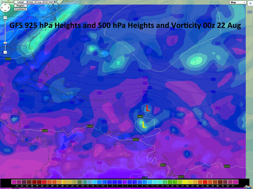
Let's take a detailed look at our biggest threat, TD9. As we have been saying for over a week now, this system was going to be the first wave to really pose a dangerous threat to the CONUS. Sure, things could go against the grain and go poof, but I seriously doubt it.
Now here is one potential major problem I see on the horizon. Late yesterday I was noticing that the low pressure area associated with the wave was moving slightly south of due west (~265 degree) movement for 6 to 12 hours. with a 0z position of 15.3N 48.8W. IR loop suggested South of due West movement or consolidation has brought the center down to about 15N 49.8W at 4z. These slight southward deviations are important as almost all recent guidance had 94L at or slightly north of 16N at 12z today. This is really significant if you ask me. It always seems like a few tenths of a degree in latitude in the East or Central Atlantic have major implications down the road in determining whether a cyclone threatens N American or swims with da fishes. And, history tells me that Atlantic cyclones with some South of West motion early in their lifecycles, are much more likely to eventually impact N America. So today's lost of latitude is interesting, to say the least. Now, with that said.
With the development pretty much expected, where will this system track? At this point most of the guidance takes the system slightly north of due west over the northern Lesser Antilles and into the northern Caribbean Sea. While this seems to be a relatively confident solution, the models have currently handled the track of this disturbance poorly over the last few days. Once again, I think the track guidance might be a little too far north, especially if the system develops more than expected.
Case in point, look at the 00z GFS. Note that the 500 hPa low center is significantly further south than the low-level center, which is displaced northward. This seems like an unlikely solution in the near term given that the system appears to becoming better vertically coupled. If the storm becomes vertically stacked (where the low and mid level low centers are aligned vertically) then the system will probably slide off further south, given the ENE/WSW orientation of the 500 hPa ridge. This should continue until the system makes it into the Eastern Caribbean. Beyond that period, the track of the system will be dictated on how much the 500 hPa ridge holds in place.
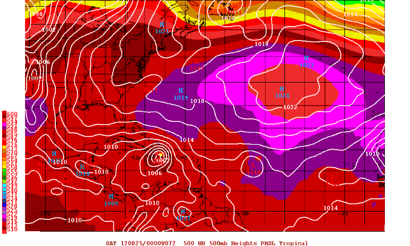
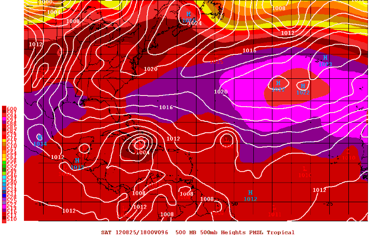
There are 2 camps as to the future movement and impacts on the United States, the GFS and the EWMCF. The model disagreement is over how much ridging will be over 94L in five days. The GFS has a large weakness the system moves northward in, while the ECMWF keeps it on a westerly course with a narrow ridge remaining in place.
GFS. showing the weakness

EWMCF not showing the weakness.


TD9 is finally dealing with the main inhibiting factor that has been present for the last few days which is dry air.
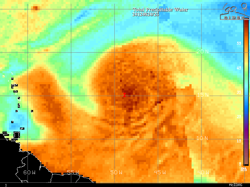
This was an image I saved early this morning. You can see a little bit of dry air intrusion on its western flank, but the ball of higher TPW nearly covers the entire circulation envelope, so its close to no longer being a problem. Unfortunately for many people, the dry air should no longer be an issue.
Now, the officially bulletin from the NHC

TROPICAL DEPRESSION NINE DISCUSSION NUMBER 1
NWS NATIONAL HURRICANE CENTER MIAMI FL AL092012
500 AM AST TUE AUG 21 2012
THE LARGE LOW PRESSURE SYSTEM THAT HAS BEEN TRAVERSING THE CENTRAL
TROPICAL ATLANTIC FOR THE PAST FEW DAYS HAS ACQUIRED ENOUGH
ORGANIZED DEEP CONVECTION NEAR THE CENTER TO BE CLASSIFIED AS A
TROPICAL DEPRESSION. THE INITIAL INTENSITY OF 30 KT IS BASED ON A
SATELLITE INTENSITY ESTIMATE OF T2.0/30 KT FROM TAFB AND T1.5/25 KT
FROM SAB. SINCE THE 0600 UTC SATELLITE CLASSIFICATIONS...
CONVECTION HAS CONTINUED TO INCREASE WITH SOME CLOUD TOP
TEMPERATURES COLDER THAN -80C NOTED JUST SOUTHWEST OF THE LOW-LEVEL
CENTER.
THE INITIAL MOTION ESTIMATE IS 270/17 KT. THE DEPRESSION IS LOCATED
SOUTH OF A DEEP-LAYER SUBTROPICAL RIDGE THAT IS FORECAST TO REMAIN
INTACT FOR THE NEXT FOUR DAYS...WHICH SHOULD KEEP THE CYCLONE
MOVING IN A WESTWARD TO WEST-NORTHWESTWARD DIRECTION THROUGH 96
HOURS. BY DAY 5...HOWEVER...THE GLOBAL MODELS ARE FORECASTING A
SHORTWAVE TROUGH TO DIG SOUTHWARD OVER THE SOUTHEASTERN U.S. AND
THE GULF OF MEXICO...WHICH IS EXPECTED TO WEAKEN THE RIDGE ACROSS
FLORIDA AND THE BAHAMAS. THIS SHOULD ALLOW THE CYCLONE TO TURN
NORTHWESTWARD AND SLOW DOWN ACROSS THE NORTH-CENTRAL CARIBBEAN SEA.
THE OFFICIAL FORECAST TRACK IS CLOSE TO THE MULTI-MODEL CONSENSUS
TVCA...WHICH IS A COMPROMISE OF THE FASTER GFS MODEL AND SLOWER
ECMWF MODEL.
OTHER THAN SOME MODEST NORTHEASTERLY VERTICAL WIND SHEAR FOR THE
NEXT 24 HOURS OR SO...ENVIRONMENTAL CONDITIONS ARE EXPECTED TO BE
QUITE FAVORABLE FOR INTENSIFICATION TO OCCUR. DURING DAYS 2-3...THE
VERTICAL SHEAR IS FORECAST TO BE THE WEAKEST AND WATER TEMPERATURES
THE WARMEST...AND THAT IS WHEN THE MOST SIGNIFICANT STRENGTHENING
SHOULD OCCUR. AT DAYS 4 AND 5...POSSIBLE INTERACTION WITH LAND
MASSES OF HAITI AND CUBA...RESPECTIVELY...IS THE PRIMARY REASON
FOR THE LEVELING OFF IN THE INTENSITY. THE OFFICIAL INTENSITY
FORECAST CLOSELY FOLLOWS THE TREND OF...BUT IS LOWER THAN...THE
SHIPS AND LGEM INTENSITY MODELS...ESPECIALLY AT DAYS 3 AND 4.
AN AIR FORCE RESERVE RECONNAISSANCE AIRCRAFT WILL INVESTIGATE THE
CYCLONE THIS AFTERNOON.
FORECAST POSITIONS AND MAX WINDS
INIT 21/0900Z 15.2N 51.2W 30 KT 35 MPH
12H 21/1800Z 15.3N 53.8W 35 KT 40 MPH
24H 22/0600Z 15.7N 57.2W 40 KT 45 MPH
36H 22/1800Z 16.0N 60.5W 50 KT 60 MPH
48H 23/0600Z 16.3N 63.6W 65 KT 75 MPH
72H 24/0600Z 16.9N 69.3W 80 KT 90 MPH
96H 25/0600Z 18.0N 74.0W 95 KT 110 MPH
120H 26/0600Z 20.0N 77.3W 95 KT 110 MPH
I WILL update this blog very soon with the other features. Got to run Clay to school
Last edited by emcf30 on Thu Aug 23, 2012 10:54 am; edited 8 times in total

emcf30- Posts : 975
Reputation : 10
Join date : 2012-07-16
Age : 93
Re: The Atlantic Express - Tropical Storm Isaac - Tropical STorm Joyce- and New AOI
![]() by StAugustineFL Tue Aug 21, 2012 7:52 am
by StAugustineFL Tue Aug 21, 2012 7:52 am

StAugustineFL- Posts : 2231
Reputation : 64
Join date : 2012-07-17
Re: The Atlantic Express - Tropical Storm Isaac - Tropical STorm Joyce- and New AOI
![]() by sangria Tue Aug 21, 2012 7:57 am
by sangria Tue Aug 21, 2012 7:57 am

sangria- Admin
- Posts : 2345
Reputation : 55
Join date : 2012-07-16
Re: The Atlantic Express - Tropical Storm Isaac - Tropical STorm Joyce- and New AOI
![]() by sangria Tue Aug 21, 2012 8:00 am
by sangria Tue Aug 21, 2012 8:00 am

sangria- Admin
- Posts : 2345
Reputation : 55
Join date : 2012-07-16
Re: The Atlantic Express - Tropical Storm Isaac - Tropical STorm Joyce- and New AOI
![]() by Tropic Bunker Tue Aug 21, 2012 8:09 am
by Tropic Bunker Tue Aug 21, 2012 8:09 am

Tropic Bunker- Posts : 70
Reputation : 1
Join date : 2012-07-16
Age : 85
Location : Miami
Re: The Atlantic Express - Tropical Storm Isaac - Tropical STorm Joyce- and New AOI
![]() by sangria Tue Aug 21, 2012 8:30 am
by sangria Tue Aug 21, 2012 8:30 am
http://www.hpc.ncep.noaa.gov/basicwx/day0-7loop.html
Also...here is a really nice wide zoomable surface analysis (in PDF)
http://www.nhc.noaa.gov/tafb/surface_latest.pdf
Current surface analysis.....look at that ridge !!!!!

sangria- Admin
- Posts : 2345
Reputation : 55
Join date : 2012-07-16
Re: The Atlantic Express - Tropical Storm Isaac - Tropical STorm Joyce- and New AOI
![]() by emcf30 Tue Aug 21, 2012 8:40 am
by emcf30 Tue Aug 21, 2012 8:40 am
What is a Leeward Low? I thought you would ask.
A lee-side or leeward (low) is thought to be caused by the stretching of a column of air as it descends on the lee-ward side of highly elevated terrain such as Hispaniola.

The island has five major mountain ranges: The Central Range, known in the Dominican Republic as the Cordillera Central, spans the central part of the island, extending from the south coast of the Dominican Republic into northwestern Haiti, where it is known as the Massif du Nord. This mountain range boasts the highest peak in the Antilles, Pico Duarte at 3,087 meters (10,128 ft) above sea level. The Cordillera Septentrional runs parallel to the Central Range across the northern end of the Dominican Republic, extending into the Atlantic Ocean as the Samaná Peninsula. The Cordillera Central and Cordillera Septentrional are separated by the lowlands of the Cibao Valley and the Atlantic coastal plains, which extend westward into Haiti as the Plaine du Nord (Northern Plain). The lowest of the ranges is the Cordillera Oriental, in the eastern part of the country.
The Sierra de Neiba rises in the southwest of the Dominican Republic, and continues northwest into Haiti, parallel to the Cordillera Central, as the Montagnes Noires, Chaîne des Matheux and the Montagnes du Trou d'Eau. The Plateau Central lies between the Massif du Nord and the Montagnes Noires, and the Plaine de l'Artibonite lies between the Montagnes Noires and the Chaîne des Matheux, opening westward toward the Gulf of Gonâve, the largest gulf of the Antilles.
The southern range begins in the southwestern most Dominican Republic as the Sierra de Bahoruco, and extends west into Haiti as the Massif de la Selle and the Massif de la Hotte, which form the mountainous spine of Haiti's southern peninsula. Pic de la Selle is the highest peak in the southern range, the third highest peak in the Antilles and consequently the highest point in Haiti, at 2,680 meters (8,790 ft) above sea level. A depression runs parallel to the southern range, between the southern range and the Chaîne des Matheux-Sierra de Neiba. It is known as the Plaine du Cul-de-Sac in Haiti, and Haiti's capital Port-au-Prince lies at its western end. The depression is home to a chain of salt lakes, including Lake Azuei in Haiti and Lake Enriquillo in the Dominican Republic.
Ok, enough of the geography lesson.
This stretching causes a spin-up of vorticity and a resulting upper level divergence. Lee-side cyclones can intensify over time as they propagate with the upper level flow and can initiate cyclogenesis. A downslope flow will be most intense if the windflow is perpendicular to the mountain range and the winds have a high velocity. Understanding how this produces a low can be complicated by other processes that occur with a downsloping flow. First, a downsloping flow produces adiabatic warming. Air warms at the dry adiabatic lapse rate as it sinks. This should cause temperatures to warm and heights to RISE (thermal expansion). Second, a downsloping wind is associated with stability (RH decreases, downward vertical velocities). How does a low or trough develop where air is sinking and stabilizing? There a several possibilities.
Theory 1: Mid-level winds which come in contact with elevated terrain suddenly experiences friction. This causes a directional change in the wind speed (ageostrophic flow). Once the air moves on the lee-ward side of the mountains it no longer experiences the friction. The friction over the mountains creates a shortwave that advects with the upper level flow. This creates a lee-side low.
Theory 2: Although the sinking air is warming at the dry adiabatic lapse rate on the lee-side, the air is still colder than the air it is replacing (katabatic wind). This creates a lee-side low since a layer of colder air is related to lower heights.
Theory 3: Flow over a mountain produces a spin-up of vorticity due to a stretching of air as the lower levels of the atmosphere fall on the lee-side (most common argument). What is troubling, is that I have often noticed lee-side lows with no vorticity showing on the 500-mb model progs and strong downward UVV's.
Theory 4: A combination of 2 or more of the previous theories. The most impressive lee-side lows occur when a pre-existing shortwave moves perpendicular over a mountain range.
Ok, now for future Issac.
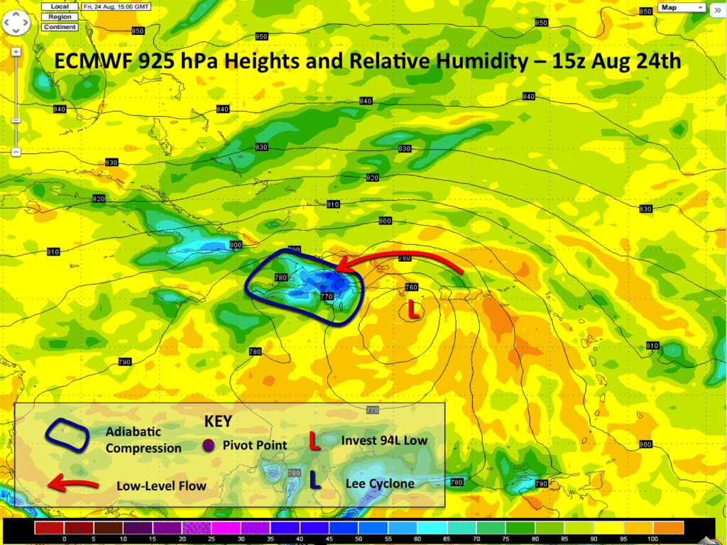
The first thing you may notice is the low center of Invest 94L, which should presumably be a tropical cyclone by this point. As it approaches Hispaniola, the strong ENE flow associated with the system will start slamming into the north coastline of Haiti and the Dominican Republic. As we know, this Island has substancial terrain that is upwards of 3000 m in spots. As 30-40 knot flow moves over the Island, this will generate substancial lift and heavy precipitation over the Island. However, as the air flows on the downslope side of the terrain, it undergoes adiabatic compression, where flow descends in height. This causes the temperature of air parcels to warm, while the water vapor content remains constant. Its important to note that at the peak of a mountain, there is substantially less precipitable water since you are much higher in the atmosphere than near the ocean surface. Allow this same low PW air to decent in height produces an area of subsidence. This area of low relative humidity is evident in the first few frames of the animation above.
However, there is a second part to this equation. In addition to adiabatic compression, a lee cyclone also forms on the downslope side of the flow. In many tropical mountain islands you often see lee vorticies produced as the prevailing flow carries alternating cyclonic and anticyclonic vorticity centers downstream. This flow, after being perturbed by the mountain flow becomes barotropically unstable, with a strip of cyclonic vorticity produced. In our case here, this extra vorticity spins up into a lee cyclone which then influences the track of the low-level circulation of 94L. Since 94L is actually smaller than the resultant lee cyclone, the binary interaction between the two vorticies results in 94L tracking into Hispaniola where the circulation becomes ill defined. At this point, the lee cyclone takes over as the chief vortex of the disturbance which continues along to the WNW now towards Jamaica.
This is an intensely complicated setup the ECMWF depicts. Lee cyclones influencing TC tracks in Hispaniola are nothing new. Even very strong TCs (e.g. David 1979) are influenced by these topographical features. In fact, you see this more frequently in the Wpac near Taiwan and Luzon where we have already seen two strong TC/terrain interactions this year.
We are still 72-96 hours out, and large changes could still occur in the track pending on how 94L organizes in the next few days. If the storm can become much better organized over the next 24-48 hours, I wouldn't discount a WSW track for a time allowing the low and mid level centers to align. However, both the GFS and ECMWF suggest the storm will remain tilted and primarily follow the low-level flow up until land interaction with Hispaniola. At this point, I'd be inclined to agree.
I still think its WAY too early to speculate what we might be dealing with post-Hispaniola. A huge amount of this depends on how much of a system we have left. For landfall lovers, the trend in the guidance is for stronger ridging in the longer range, so I'm leaning towards this system potentially having an impact on the US as opposed to recurving out into the Atlantic. Where that might be and how much of a cyclone we have left are huge ??? at this point.
credit: Phill Papin.
emcf30- Posts : 975
Reputation : 10
Join date : 2012-07-16
Age : 93
Re: The Atlantic Express - Tropical Storm Isaac - Tropical STorm Joyce- and New AOI
![]() by emcf30 Tue Aug 21, 2012 8:52 am
by emcf30 Tue Aug 21, 2012 8:52 am
sangria wrote:Morning Trop....I would sure like to see it it go north also, but.....unless, I am just not seeing it.....I don't see the Bermuda High weakening on the west side, and a weakness opening in the this 7 day surface loop....
http://www.hpc.ncep.noaa.gov/basicwx/day0-7loop.html
Also...here is a really nice wide zoomable surface analysis (in PDF)
http://www.nhc.noaa.gov/tafb/surface_latest.pdf
Current surface analysis.....look at that ridge !!!!!
I am going to have to agree on this surface analysis for now San. That is the way I see it at the moment. IMO. Subject to change at any given moment
emcf30- Posts : 975
Reputation : 10
Join date : 2012-07-16
Age : 93
Re: The Atlantic Express - Tropical Storm Isaac - Tropical STorm Joyce- and New AOI
![]() by sangria Tue Aug 21, 2012 8:59 am
by sangria Tue Aug 21, 2012 8:59 am
sangria- Admin
- Posts : 2345
Reputation : 55
Join date : 2012-07-16
Re: The Atlantic Express - Tropical Storm Isaac - Tropical STorm Joyce- and New AOI
![]() by emcf30 Tue Aug 21, 2012 8:59 am
by emcf30 Tue Aug 21, 2012 8:59 am

emcf30- Posts : 975
Reputation : 10
Join date : 2012-07-16
Age : 93
Re: The Atlantic Express - Tropical Storm Isaac - Tropical STorm Joyce- and New AOI
![]() by emcf30 Tue Aug 21, 2012 9:04 am
by emcf30 Tue Aug 21, 2012 9:04 am
sangria wrote:What a great post!!! I have never heard of this before....would the TC have to hit at exactly the right place, and at the right angle for this to occur?
There is no exact "sweet spot" per say. The key factor is the main circulation approaching the island to the South and the Low Level flow from the Northeast. The mountain range will do the rest. Another note, this is similar to what happens in the Plains coming out of the Rocky Mountains in the spring. Thus, Tornado Ally.
emcf30- Posts : 975
Reputation : 10
Join date : 2012-07-16
Age : 93
Re: The Atlantic Express - Tropical Storm Isaac - Tropical STorm Joyce- and New AOI
![]() by emcf30 Tue Aug 21, 2012 9:51 am
by emcf30 Tue Aug 21, 2012 9:51 am

emcf30- Posts : 975
Reputation : 10
Join date : 2012-07-16
Age : 93
Re: The Atlantic Express - Tropical Storm Isaac - Tropical STorm Joyce- and New AOI
![]() by scouter534 Tue Aug 21, 2012 10:00 am
by scouter534 Tue Aug 21, 2012 10:00 am

scouter534- Posts : 128
Reputation : 1
Join date : 2012-07-16
Age : 62
Location : Pompano Beach, FL
Re: The Atlantic Express - Tropical Storm Isaac - Tropical STorm Joyce- and New AOI
![]() by emcf30 Tue Aug 21, 2012 10:05 am
by emcf30 Tue Aug 21, 2012 10:05 am
Last edited by emcf30 on Tue Aug 21, 2012 10:20 am; edited 1 time in total
emcf30- Posts : 975
Reputation : 10
Join date : 2012-07-16
Age : 93
Re: The Atlantic Express - Tropical Storm Isaac - Tropical STorm Joyce- and New AOI
![]() by emcf30 Tue Aug 21, 2012 10:08 am
by emcf30 Tue Aug 21, 2012 10:08 am

emcf30- Posts : 975
Reputation : 10
Join date : 2012-07-16
Age : 93
Re: The Atlantic Express - Tropical Storm Isaac - Tropical STorm Joyce- and New AOI
![]() by scouter534 Tue Aug 21, 2012 10:22 am
by scouter534 Tue Aug 21, 2012 10:22 am
scouter534- Posts : 128
Reputation : 1
Join date : 2012-07-16
Age : 62
Location : Pompano Beach, FL
Re: The Atlantic Express - Tropical Storm Isaac - Tropical STorm Joyce- and New AOI
![]() by emcf30 Tue Aug 21, 2012 10:38 am
by emcf30 Tue Aug 21, 2012 10:38 am
scouter534 wrote:Wait! I thought we were throwing those out!
LOL scout. It does not matter which camp you are in at the moment. Either one shows a potential threat to the SE.
emcf30- Posts : 975
Reputation : 10
Join date : 2012-07-16
Age : 93
Re: The Atlantic Express - Tropical Storm Isaac - Tropical STorm Joyce- and New AOI
![]() by sangria Tue Aug 21, 2012 10:50 am
by sangria Tue Aug 21, 2012 10:50 am
sangria- Admin
- Posts : 2345
Reputation : 55
Join date : 2012-07-16
Re: The Atlantic Express - Tropical Storm Isaac - Tropical STorm Joyce- and New AOI
![]() by scouter534 Tue Aug 21, 2012 10:51 am
by scouter534 Tue Aug 21, 2012 10:51 am

scouter534- Posts : 128
Reputation : 1
Join date : 2012-07-16
Age : 62
Location : Pompano Beach, FL
Re: The Atlantic Express - Tropical Storm Isaac - Tropical STorm Joyce- and New AOI
![]() by StAugustineFL Tue Aug 21, 2012 11:34 am
by StAugustineFL Tue Aug 21, 2012 11:34 am
http://www.nhc.noaa.gov/archive/2004/IVAN_graphics.shtml
StAugustineFL- Posts : 2231
Reputation : 64
Join date : 2012-07-17
Re: The Atlantic Express - Tropical Storm Isaac - Tropical STorm Joyce- and New AOI
![]() by emcf30 Tue Aug 21, 2012 11:37 am
by emcf30 Tue Aug 21, 2012 11:37 am
StAugustineFL wrote:Any chance of this? What I mean is a further west track in time.
http://www.nhc.noaa.gov/archive/2004/IVAN_graphics.shtml
Yes definitely Aug. Going to have to watch the ridge. I think, at this time it will be further to the East based on the strength and location of the ridge forecast
emcf30- Posts : 975
Reputation : 10
Join date : 2012-07-16
Age : 93
Re: The Atlantic Express - Tropical Storm Isaac - Tropical STorm Joyce- and New AOI
![]() by emcf30 Tue Aug 21, 2012 2:12 pm
by emcf30 Tue Aug 21, 2012 2:12 pm

emcf30- Posts : 975
Reputation : 10
Join date : 2012-07-16
Age : 93
Re: The Atlantic Express - Tropical Storm Isaac - Tropical STorm Joyce- and New AOI
![]() by StAugustineFL Tue Aug 21, 2012 3:03 pm
by StAugustineFL Tue Aug 21, 2012 3:03 pm

StAugustineFL- Posts : 2231
Reputation : 64
Join date : 2012-07-17
Re: The Atlantic Express - Tropical Storm Isaac - Tropical STorm Joyce- and New AOI
![]() by emcf30 Tue Aug 21, 2012 4:56 pm
by emcf30 Tue Aug 21, 2012 4:56 pm

ROPICAL STORM ISAAC DISCUSSION NUMBER 3
NWS NATIONAL HURRICANE CENTER MIAMI FL AL092012
500 PM AST TUE AUG 21 2012
AN AIR FORCE RESERVE HURRICANE HUNTER AIRCRAFT INVESTIGATING THE
DEPRESSION REPORTED 44-KT FLIGHT-LEVEL WINDS AT 1000 FT TO THE
NORTHEAST OF THE CENTER...AS WELL AS BIAS-CORRECTED SFMR SURFACE
WINDS ESTIMATES OF 35 KT. THE MINIMUM CENTRAL PRESSURE WAS NEAR
1005 MB. BASED ON THESE DATA...THE DEPRESSION IS UPGRADED TO
TROPICAL STORM ISAAC. DESPITE THE UPGRADE...THE CYCLONE REMAINS
SOMEWHAT DISORGANIZED...WITH THE LOW-LEVEL CENTER PARTLY EXPOSED TO
THE NORTH OF THE MAIN CONVECTIVE MASS.
THE LOW-LEVEL CENTER HAS NUDGED NORTHWARD DURING THE AFTERNOON...BUT
THE LONGER TERM MOTION IS 275/15. ISAAC REMAINS SOUTH OF A
DEEP-LAYER SUBTROPICAL RIDGE THAT IS FORECAST TO REMAIN INTACT
FOR THE NEXT 72 HR...WHICH SHOULD KEEP THE CYCLONE MOVING GENERALLY
WESTWARD AS SHOWN BY THE TIGHTLY CLUSTERED TRACK MODEL GUIDANCE.
AFTER THAT...THE GLOBAL MODELS CONTINUE TO FORECAST A SHORTWAVE
TROUGH TO DIG SOUTHWARD OVER THE SOUTHEASTERN U.S. AND THE GULF OF
MEXICO...WHICH IS EXPECTED TO WEAKEN THE RIDGE ACROSS FLORIDA AND
THE BAHAMAS. THIS SHOULD ALLOW THE CYCLONE TO TURN WEST-
NORTHWESTWARD AND SLOW DOWN OVER THE NORTH-CENTRAL CARIBBEAN SEA AND
THE GREATER ANTILLES. THE GUIDANCE HAS BECOME LESS CONSISTENT
SINCE THE PREVIOUS ADVISORY. WHILE THE CENTER OF THE GUIDANCE
ENVELOPE HAS CHANGED LITTLE...THE ECMWF HAS SHIFTED WELL TO THE
LEFT OF ITS PREVIOUS FORECAST AND NOW CALLS FOR A WESTWARD MOTION
AFTER ISAAC PASSES HISPANIOLA. THE GFS ENSEMBLES HAVE ALSO SHIFTED
WESTWARD...ALTHOUGH THE ENSEMBLE MEAN STILL LIES NEAR THE FORECAST
TRACK. THE NEW TRACK IS NUDGED A LITTLE TO THE NORTH OF THE
PREVIOUS TRACK BEFORE 72 HR...AND THEN IS NUDGED A LITTLE TO THE
RIGHT THEREAFTER. THE TRACK FORECAST AFTER 72 HR LIES NEAR THE
LEFT EDGE OF THE GUIDANCE ENVELOPE...WITH ONLY THE ECMWF WELL TO
THE LEFT OF THE CURRENT FORECAST. USERS ARE CAUTIONED THAT FIVE-DAY
TRACK ERRORS AVERAGE ABOUT 225 N MI.
ISAAC CONTINUES TO EXPERIENCE SOME LIGHT NORTHEASTERLY VERTICAL WIND
SHEAR...AND IT MAY NOT YET HAVE FULLY MIXED OUT THE DRY AIR THAT
HAS BEEN AFFECTING IT. THE SHEAR IS FORECAST TO DIMINISH IN 12-24
HR...WHICH SHOULD ALLOW SOME STRENGTHENING. THAT BEING SAID...THE
GFDL AND HWRF MODELS HAVE BACKED OFF ON THEIR FORECASTS OF
INTENSIFICATION...AND THE SHIPS AND LGEM MODELS ARE ALSO LESS
BULLISH. BASED ON THIS...THE NEW INTENSITY FORECAST SHOWS A LITTLE
LESS STRENGTHENING THAN THE PREVIOUS ADVISORY. THE INTENSITY
FORECAST AFTER 72 HR HAS AGAIN BEEN REDUCED DUE TO THE FORECAST
TRACK SHOWING INCREASED LAND INTERACTION WITH HISPANIOLA AND CUBA.
FORECAST POSITIONS AND MAX WINDS
INIT 21/2100Z 15.4N 53.9W 35 KT 40 MPH
12H 22/0600Z 15.6N 56.4W 40 KT 45 MPH
24H 22/1800Z 15.9N 59.8W 45 KT 50 MPH
36H 23/0600Z 16.3N 63.1W 50 KT 60 MPH
48H 23/1800Z 16.6N 66.3W 65 KT 75 MPH
72H 24/1800Z 17.0N 71.0W 75 KT 85 MPH
96H 25/1800Z 19.5N 75.0W 75 KT 85 MPH
120H 26/1800Z 21.5N 78.0W 65 KT 75 MPH...INLAND

emcf30- Posts : 975
Reputation : 10
Join date : 2012-07-16
Age : 93
Re: The Atlantic Express - Tropical Storm Isaac - Tropical STorm Joyce- and New AOI
![]() by gomexwx Tue Aug 21, 2012 8:58 pm
by gomexwx Tue Aug 21, 2012 8:58 pm

gomexwx- Posts : 641
Reputation : 63
Join date : 2012-07-16
Location : On an Acre somewhere on the gulf Coast
Re: The Atlantic Express - Tropical Storm Isaac - Tropical STorm Joyce- and New AOI
![]() by emcf30 Wed Aug 22, 2012 7:27 am
by emcf30 Wed Aug 22, 2012 7:27 am
Isaac has become better organized overnight both structurally and to the eyes.

Reconnaissance aircraft have found that the central pressure has fallen to 1003 millibars and this trend should continue. Tropical Storm conditions will start to affect the Leeward Islands later on today and into the night. Isaac is headed due West towards the Islands at 16 mph. I currently see nothing that will remotely change the Westward movement for the next couple of days. This motion will take the center of Isaac South of Puerto Rico but will sustain strong Tropical Storm wind with possible Hurricane Gust. Puerto Rico is currently under a Hurricane Watch.
After tracking to the South of Puerto Rico a Westward motion is expected to continue and then make it's first landfall near Barahona, Dominica Republic, according to the official forecast from the National Hurricane Center.
Barahona, which is also known as Santa Cruz de Barahona, is the main city of the Barahona Province, in the south of the Dominican Republic. It is one of the most important cities on the island, with a very active port and many ecotourism attractions. The city is also a centre of sugar production and industry. This would be a major hit to that country's economy.

Isaac is expected to continue exit Haiti and then travel through the 50 mile wide Windward Passage on his way with a visit to East Cuba. A second landfall is expected just to the North of Guantanamo Bay and exit just to the East of Playa Santa Lucia, as a Hurricane, and on it's way with a visit to the United States. A third landfall is expected by the NHC to be in the Key Largo, Florida City area. Now, this is just the way it is now and will most likely change several times from now to this weekend.
The 00Z GFS run with data from Hurricane Hunters and Gulfstream Air Sampling has a little further East track than yesterday, but only by 50 or so miles. The 06Z run show a similar path but exiting the GOM and then hookin back into the Big Bend area
00Z GFS

As you can see the models are trending back to the East this morning and are in much better agreement in the long term. Florida is definitely in it's sites. We shall see if this trend continues.


* ATLANTIC SHIPS INTENSITY FORECAST *
* GOES AVAILABLE, OHC AVAILABLE *
* ISAAC AL092012 08/22/12 00 UTC *
TIME (HR) 0 6 12 18 24 36 48 60 72 84 96 108 120
V (KT) NO LAND 35 39 43 49 54 64 74 82 91 91 96 96 101
V (KT) LAND 35 39 43 49 54 64 74 82 91 79 71 48 38
V (KT) LGE mod 35 38 41 45 48 57 67 79 90 85 80 51 39
Storm Type TROP TROP TROP TROP TROP TROP TROP TROP TROP TROP TROP TROP TROP
SHEAR (KT) 6 8 10 11 6 11 4 10 4 5 9 6 3
SHEAR ADJ (KT) 7 3 3 6 3 0 0 -4 -1 1 1 0 8
SHEAR DIR 357 327 336 332 325 322 308 354 242 211 208 227 296
SST (C) 28.4 28.6 28.7 28.9 29.0 28.9 28.6 28.6 28.6 29.1 29.4 29.4 29.4
emcf30- Posts : 975
Reputation : 10
Join date : 2012-07-16
Age : 93
Re: The Atlantic Express - Tropical Storm Isaac - Tropical STorm Joyce- and New AOI
![]() by GrillinInTheEye Wed Aug 22, 2012 7:34 am
by GrillinInTheEye Wed Aug 22, 2012 7:34 am

GrillinInTheEye- Posts : 153
Reputation : 1
Join date : 2012-07-17
Age : 56
Re: The Atlantic Express - Tropical Storm Isaac - Tropical STorm Joyce- and New AOI
![]() by emcf30 Wed Aug 22, 2012 7:41 am
by emcf30 Wed Aug 22, 2012 7:41 am
The Euro is still holding strong keeping Isaac to the South and the bringing it into the Central GOM and into Louisiana as a Cat 3 Hurricane. The ECMWF is much faster this run, with the system all the way in the middle of the Gulf of Mexico at 168 hours. That is consistent with a stronger ridge. I honestly have no idea if its right though, its so different from the rest of the guidance. Hispaniola is known to have detrimental effects on the system, after becoming vertically coupled it decouples again. The ECMWF is supporting this solution, which allows for a further west track. On the flip side, the GFS/GGEM support the storm remaining vertically coupled through the passage of Hispaniola so its able to take advantage of the brief weakness and track further NW. This is one of those forecasts where its probably just as good to flip a coin at this point. Who knows
emcf30- Posts : 975
Reputation : 10
Join date : 2012-07-16
Age : 93
Re: The Atlantic Express - Tropical Storm Isaac - Tropical STorm Joyce- and New AOI
![]() by sangria Wed Aug 22, 2012 8:06 am
by sangria Wed Aug 22, 2012 8:06 am
sangria- Admin
- Posts : 2345
Reputation : 55
Join date : 2012-07-16
Re: The Atlantic Express - Tropical Storm Isaac - Tropical STorm Joyce- and New AOI
![]() by sangria Wed Aug 22, 2012 8:09 am
by sangria Wed Aug 22, 2012 8:09 am

sangria- Admin
- Posts : 2345
Reputation : 55
Join date : 2012-07-16
Re: The Atlantic Express - Tropical Storm Isaac - Tropical STorm Joyce- and New AOI
![]() by sangria Wed Aug 22, 2012 8:10 am
by sangria Wed Aug 22, 2012 8:10 am
US Watch/Warning
000
WTNT34 KNHC 221153
TCPAT4
BULLETIN
TROPICAL STORM ISAAC INTERMEDIATE ADVISORY NUMBER 5A
NWS NATIONAL HURRICANE CENTER MIAMI FL AL092012
800 AM AST WED AUG 22 2012
...ISAAC NEARING THE LESSER ANTILLES...HURRICANE WATCH ISSUED FOR
THE BRITISH VIRGIN ISLANDS...
SUMMARY OF 800 AM AST...1200 UTC...INFORMATION
----------------------------------------------
LOCATION...15.7N 58.4W
ABOUT 210 MI...340 KM E OF GUADELOUPE
MAXIMUM SUSTAINED WINDS...45 MPH...75 KM/H
PRESENT MOVEMENT...W OR 270 DEGREES AT 19 MPH...31 KM/H
MINIMUM CENTRAL PRESSURE...1004 MB...29.65 INCHES
WATCHES AND WARNINGS
--------------------
CHANGES WITH THIS ADVISORY...
THE GOVERNMENT OF ANTIGUA HAS ISSUED A HURRICANE WATCH FOR THE
BRITISH VIRGIN ISLANDS.
SUMMARY OF WATCHES AND WARNINGS IN EFFECT...
A TROPICAL STORM WARNING IS IN EFFECT FOR...
* MARTINIQUE
* DOMINICA
* GUADELOUPE AND THE SURROUNDING ISLANDS...AND ST. MARTIN
* ST. KITTS...NEVIS...ANTIGUA...BARBUDA...MONTSERRAT...AND ANGUILLA
* SABA...ST. EUSTATIUS...AND ST. MAARTEN
* BRITISH VIRGIN ISLANDS
* PUERTO RICO...VIEQUES...CULEBRA...AND THE U.S. VIRGIN ISLANDS
A HURRICANE WATCH IS IN EFFECT FOR...
* PUERTO RICO...VIEQUES...CULEBRA...AND THE U.S. AND BRITISH VIRGIN
ISLANDS
* SOUTH COAST OF DOMINICAN REPUBLIC FROM ISLA SAONA WESTWARD TO THE
HAITI-DOMINICAN REPUBLIC SOUTHERN BORDER
A TROPICAL STORM WATCH IS IN EFFECT FOR...
* NORTH COAST OF DOMINICAN REPUBLIC FROM THE HAITI-DOMINICAN
REPUBLIC NORTHERN BORDER EASTWARD TO NORTH OF ISLA SAONA
A HURRICANE WATCH MEANS THAT HURRICANE CONDITIONS ARE POSSIBLE
WITHIN THE WATCH AREA. A WATCH IS TYPICALLY ISSUED 48 HOURS
BEFORE THE ANTICIPATED FIRST OCCURRENCE OF TROPICAL-STORM-FORCE
WINDS...CONDITIONS THAT MAKE OUTSIDE PREPARATIONS DIFFICULT OR
DANGEROUS.
A TROPICAL STORM WARNING MEANS THAT TROPICAL STORM CONDITIONS ARE
EXPECTED SOMEWHERE WITHIN THE WARNING AREA WITHIN 36 HOURS.
A TROPICAL STORM WATCH MEANS THAT TROPICAL STORM CONDITIONS ARE
POSSIBLE WITHIN THE WATCH AREA...GENERALLY WITHIN 48 HOURS.
INTERESTS IN HAITI AND CUBA SHOULD MONITOR THE PROGRESS OF
ISAAC.
FOR STORM INFORMATION SPECIFIC TO YOUR AREA IN THE UNITED
STATES...PLEASE MONITOR PRODUCTS ISSUED BY YOUR LOCAL NATIONAL
WEATHER SERVICE FORECAST OFFICE. FOR STORM INFORMATION SPECIFIC TO
YOUR AREA OUTSIDE THE UNITED STATES...PLEASE MONITOR PRODUCTS
ISSUED BY YOUR NATIONAL METEOROLOGICAL SERVICE.
DISCUSSION AND 48-HOUR OUTLOOK
------------------------------
AT 800 AM AST...1200 UTC...THE CENTER OF TROPICAL STORM ISAAC WAS
LOCATED NEAR LATITUDE 15.7 NORTH...LONGITUDE 58.4 WEST. ISAAC IS
MOVING TOWARD THE WEST NEAR 19 MPH...31 KM/H...AND THIS GENERAL
MOTION IS EXPECTED TO CONTINUE FOR THE NEXT COUPLE OF DAYS. ON THE
FORECAST TRACK...THE CENTER OF ISAAC SHOULD MOVE THROUGH THE
LEEWARD ISLANDS THIS EVENING...AND MOVE OVER THE NORTHEASTERN
CARIBBEAN SEA ON THURSDAY.
MAXIMUM SUSTAINED WINDS ARE NEAR 45 MPH...75 KM/H...WITH HIGHER
GUSTS. STRENGTHENING IS FORECAST DURING THE NEXT 48 HOURS...AND
ISAAC COULD BECOME A HURRICANE BY THURSDAY.
TROPICAL-STORM-FORCE WINDS EXTEND OUTWARD UP TO 45 MILES...75 KM
FROM THE CENTER.
THE MINIMUM CENTRAL PRESSURE ESTIMATED FROM RECONNAISSANCE AIRCRAFT
DATA IS 1004 MB...29.65 INCHES.
HAZARDS AFFECTING LAND
----------------------
WIND...TROPICAL STORM CONDITIONS ARE EXPECTED TO REACH THE LEEWARD
ISLANDS BY THIS AFTERNOON OR EVENING...MAKING OUTSIDE PREPARATIONS
DIFFICULT OR DANGEROUS. TROPICAL STORM CONDITIONS ARE EXPECTED OVER
PUERTO RICO AND THE U.S. AND BRITISH VIRGIN ISLANDS ON THURSDAY.
HURRICANE CONDITIONS ARE POSSIBLE OVER PUERTO RICO AND THE U.S.
VIRGIN ISLANDS ON THURSDAY.
RAINFALL...TOTAL RAIN ACCUMULATIONS OF 4 TO 8 INCHES ARE POSSIBLE
OVER THE NORTHERN WINDWARD ISLANDS AND THE LEEWARD ISLANDS. TOTAL
RAIN ACCUMULATIONS OF 1 TO 3 INCHES WITH MAXIMUM AMOUNTS OF 6
INCHES ARE POSSIBLE OVER PUERTO RICO AND THE VIRGIN ISLANDS. THESE
RAINS COULD CAUSE FLASH FLOODS AND MUD SLIDES.
STORM SURGE...A STORM SURGE WILL RAISE WATER LEVELS BY AS MUCH AS
1 TO 3 FEET ABOVE NORMAL TIDE LEVELS IN THE NORTHERN LEEWARD
ISLANDS...PUERTO RICO...AND THE U.S. AND BRITISH VIRGIN ISLANDS.
NEAR THE COAST...THE SURGE WILL BE ACCOMPANIED BY DANGEROUS WAVES.
SURF...DANGEROUS SURF AND RIP CURRENT CONDITIONS WILL AFFECT THE
WINDWARD AND LEEWARD ISLANDS DURING THE NEXT COUPLE OF DAYS.
PLEASE CONSULT PRODUCTS FROM YOUR LOCAL WEATHER OFFICE FOR MORE
INFORMATION.
NEXT ADVISORY
-------------
NEXT COMPLETE ADVISORY...1100 AM AST.
$$
FORECASTER BEVEN
sangria- Admin
- Posts : 2345
Reputation : 55
Join date : 2012-07-16
Re: The Atlantic Express - Tropical Storm Isaac - Tropical STorm Joyce- and New AOI
![]() by emcf30 Wed Aug 22, 2012 8:19 am
by emcf30 Wed Aug 22, 2012 8:19 am
emcf30- Posts : 975
Reputation : 10
Join date : 2012-07-16
Age : 93
Re: The Atlantic Express - Tropical Storm Isaac - Tropical STorm Joyce- and New AOI
![]() by scouter534 Wed Aug 22, 2012 8:22 am
by scouter534 Wed Aug 22, 2012 8:22 am
scouter534- Posts : 128
Reputation : 1
Join date : 2012-07-16
Age : 62
Location : Pompano Beach, FL
Re: The Atlantic Express - Tropical Storm Isaac - Tropical STorm Joyce- and New AOI
![]() by emcf30 Wed Aug 22, 2012 8:42 am
by emcf30 Wed Aug 22, 2012 8:42 am
emcf30- Posts : 975
Reputation : 10
Join date : 2012-07-16
Age : 93
Re: The Atlantic Express - Tropical Storm Isaac - Tropical STorm Joyce- and New AOI
![]() by emcf30 Wed Aug 22, 2012 9:08 am
by emcf30 Wed Aug 22, 2012 9:08 am
Okay Florida... it's time to wake up. Isaac is getting organized and the odds are increasing that it's going to be a problem... a big enough problem that preparation is likely to be required. The exact angle of approach is still uncertain, and a slight difference changes who gets the worst of it, but most plausible future tracks show an impact on the state. (There's a chance it could miss to the east, but that appears the least likely scenario.) If the storm turns near eastern Cuba, as the American GFS computer forecast shows, the storm will impact the Middle/Upper Keys and the Miami/Ft. Lauderdale area... and possibly the Tampa/Orlando area as well. (Setting up a possible nightmare scenario for Florida insurance.) This scenario would seem to limit how strong the storm could get because it would have to track over some of the Caribbean mountains, but there's still plenty of warm water between Cuba and Florida. A track farther west, however, in the direction of the European ECMWF computer forecast, the storm has impact on the west coast of the state in a big way, and perhaps the Panhandle. A hurricane on this track would seem to have an opportunity to get stronger. The bottom line, starting in the Keys immediately, it's time to begin paying attention to hurricane plans. The NHC will be deploying their full resources over the next couple of days to gather the best data, which can refine and improve the forecast... so we'll be getting the best that modern technology can provide by Friday. Stay tuned... and wake your friends up as well.
emcf30- Posts : 975
Reputation : 10
Join date : 2012-07-16
Age : 93
Re: The Atlantic Express - Tropical Storm Isaac - Tropical STorm Joyce- and New AOI
![]() by scouter534 Wed Aug 22, 2012 10:12 am
by scouter534 Wed Aug 22, 2012 10:12 am
scouter534- Posts : 128
Reputation : 1
Join date : 2012-07-16
Age : 62
Location : Pompano Beach, FL
Re: The Atlantic Express - Tropical Storm Isaac - Tropical STorm Joyce- and New AOI
![]() by emcf30 Wed Aug 22, 2012 3:33 pm
by emcf30 Wed Aug 22, 2012 3:33 pm
Well Gomey was the first to call this in chat for sure, but it sure as hell looks like the center has relocated, although it is not official yet but something is definitely going on. Methinks recon has measured old, failing circulation that was at 16.1. The pressures are rising in this area and are now up to 1007mb What this would imply is old circulation has gone POOF and the new one is taking over at 15.2N.
Also, this is even depicted on the latest steering maps..

emcf30- Posts : 975
Reputation : 10
Join date : 2012-07-16
Age : 93
Re: The Atlantic Express - Tropical Storm Isaac - Tropical STorm Joyce- and New AOI
![]() by emcf30 Wed Aug 22, 2012 6:39 pm
by emcf30 Wed Aug 22, 2012 6:39 pm
emcf30- Posts : 975
Reputation : 10
Join date : 2012-07-16
Age : 93
Re: The Atlantic Express - Tropical Storm Isaac - Tropical STorm Joyce- and New AOI
![]() by emcf30 Wed Aug 22, 2012 11:13 pm
by emcf30 Wed Aug 22, 2012 11:13 pm


TROPICAL STORM ISAAC DISCUSSION NUMBER 8
NWS NATIONAL HURRICANE CENTER MIAMI FL AL092012
1100 PM AST WED AUG 22 2012
AN AIR FORCE HURRICANE HUNTER AIRCRAFT INVESTIGATED ISAAC SEVERAL
HOURS AGO AND FOUND THAT THE CENTER WAS STILL NOT WELL-DEFINED AND
THE INTENSITY ESTIMATE OF 40 KT WAS PROBABLY A LITTLE ON THE HIGH
SIDE. HOWEVER...DROPSONDE DATA FROM A NOAA AIRCRAFT CURRENTLY
INVESTIGATING THE STORM SUGGEST THAT THE CENTER HAS PROBABLY BECOME
A LITTLE BETTER DEFINED AND THAT THE MINIMUM PRESSURE HAS DROPPED A
BIT. THERE HAS ALSO BEEN AN INCREASE IN COLD-TOPPED CONVECTION
NEAR AND OVER THE ESTIMATED CENTER SO THE CURRENT INTENSITY IS HELD
AT 40 KT. ISAAC HAS DEVELOPED AN IMPRESSIVE UPPER-LEVEL OUTFLOW
PATTERN AND DYNAMICAL GUIDANCE SHOWS THAT THE VERTICAL SHEAR SHOULD
REMAIN WEAK DURING THE NEXT SEVERAL DAYS. THEREFORE THE PRIMARY
IMPEDIMENT TO STRENGTHENING SHOULD BE THE INTERACTION WITH THE
MOUNTAINOUS TERRAIN OF HISPANIOLA AND EASTERN CUBA. THE MOST
RECENT RUNS OF THE HWRF AND GFDL SHOW SIMILAR AMOUNTS OF LAND
INTERACTION BUT ARE NOT IN GOOD AGREEMENT ON THE INTENSITY FORECAST
AS THE FORMER MODEL SHOWS MUCH LESS STRENGTHENING THAN THE LATTER.
THE OFFICIAL WIND SPEED FORECAST IS IN REASONABLE AGREEMENT WITH
THE LATEST STATISTICAL-DYNAMICAL GUIDANCE.
AFTER A SLIGHT SOUTHWARD RELOCATION OF THE CENTER...THE INITIAL
MOTION CONTINUES BASICALLY WESTWARD OR 270/17. ISAAC SHOULD
CONTINUE TO MOVE WESTWARD TO WEST-NORTHWESTWARD FOR THE NEXT COUPLE
OF DAYS ALONG THE SOUTHERN PERIPHERY OF THE SUBTROPICAL RIDGE. THE
GLOBAL MODELS CONTINUE TO DEPICT A BREAK IN THE RIDGE IN THE
VICINITY OF FLORIDA IN SEVERAL DAYS...WHICH SHOULD INDUCE A MORE
NORTHWARD COMPONENT OF MOTION. THE ECMWF MODEL SHOWS LESS OF A
BREAK IN THE RIDGE THAN THE GFS SOLUTION. CONSEQUENTLY...THE ECMWF
TRACK IS SOMEWHAT TO THE SOUTHWEST OF MOST OF THE OTHER TRACK
MODELS WHICH WOULD LESSEN THE THREAT TO FLORIDA. THE OFFICIAL
TRACK FORECAST FOR THIS ADVISORY IS QUITE CLOSE TO THE PREVIOUS ONE
AND ALSO VERY CLOSE TO THE DYNAMICAL MODEL CONSENSUS.
FORECAST POSITIONS AND MAX WINDS
INIT 23/0300Z 15.8N 63.0W 40 KT 45 MPH
12H 23/1200Z 16.2N 65.4W 45 KT 50 MPH
24H 24/0000Z 16.9N 68.1W 55 KT 65 MPH
36H 24/1200Z 17.5N 70.5W 65 KT 75 MPH
48H 25/0000Z 18.6N 72.7W 55 KT 65 MPH
72H 26/0000Z 21.5N 77.0W 60 KT 70 MPH...ON NORTH COAST OF CUBA
96H 27/0000Z 24.0N 80.5W 65 KT 75 MPH
120H 28/0000Z 27.0N 83.5W 70 KT 80 MPH


* ATLANTIC SHIPS INTENSITY FORECAST *
* GOES AVAILABLE, OHC AVAILABLE *
* ISAAC AL092012 08/22/12 00 UTC *
TIME (HR) 0 6 12 18 24 36 48 60 72 84 96 108 120
V (KT) NO LAND 35 39 43 49 54 64 74 82 91 91 96 96 101
V (KT) LAND 35 39 43 49 54 64 74 82 91 79 71 48 38
V (KT) LGE mod 35 38 41 45 48 57 67 79 90 85 80 51 39
Storm Type TROP TROP TROP TROP TROP TROP TROP TROP TROP TROP TROP TROP TROP
SHEAR (KT) 6 8 10 11 6 11 4 10 4 5 9 6 3
SHEAR ADJ (KT) 7 3 3 6 3 0 0 -4 -1 1 1 0 8
SHEAR DIR 357 327 336 332 325 322 308 354 242 211 208 227 296
SST (C) 28.4 28.6 28.7 28.9 29.0 28.9 28.6 28.6 28.6 29.1 29.4 29.4 29.4
emcf30- Posts : 975
Reputation : 10
Join date : 2012-07-16
Age : 93
Re: The Atlantic Express - Tropical Storm Isaac - Tropical STorm Joyce- and New AOI
![]() by emcf30 Wed Aug 22, 2012 11:23 pm
by emcf30 Wed Aug 22, 2012 11:23 pm

emcf30- Posts : 975
Reputation : 10
Join date : 2012-07-16
Age : 93
Re: The Atlantic Express - Tropical Storm Isaac - Tropical STorm Joyce- and New AOI
![]() by emcf30 Thu Aug 23, 2012 7:44 am
by emcf30 Thu Aug 23, 2012 7:44 am

Isaac seems to be trying to consolidate it's mid (MLC) and low level circulations (LLC). Infact, they are more closely aligned than they were this time yesterday.
850MB

500mb

The center is having a very difficult time finding it's identity. Keeps relocating to it's South. When we see wording like in the 5am Discussion, one can expect some major changes down the road.
RATHER THAN INITIALIZE THE CENTER OF ISAAC WELL TO THE SOUTH OF THE
PREVIOUS TRACK...I HAVE OPTED TO USE A BLEND OF THE RECON FIXES...
SATELLITE IMAGERY...DATA FROM NEARBY NOAA BUOY 42060...AND A 06Z
CONSENSUS FORECAST POSITION FROM THE GFS...ECMWF...AND UKMET
MODELS. THE INITIAL INTENSITY WAS ALSO DECREASED TO 35 KT BASED ON
DATA FROM THE RECON AIRCRAFT AND NOAA BUOY 42060.
We are going to need some serious latitude gains over the next 24 hours in order to even come close to staying on any projected path. Isaac is currently further South than it was when it was first initiated as a Tropical Depression. That means the long-term motion has been slightly south of west the last 3 days. I am confused, as usual.
Isaac's bursting on and off again pattern is linear in nature and the convection, albeit strong at times, is not persistent. One thing I can say is that the outflow pattern is becoming beautiful, which is generally a sign of a well developed system. (Slaps self in face remembering Ernesto)
According to the NHC, Isaac is currently tracking nearly due West at a forward speed of 13 mph. Boy, Isaac sure has put the brakes on this morning. This tells me he is fixing to undergo some intensifying and/or going to make a turn. The models are forecasting a sharp turn to the northwest today or perhaps another reformation of the center of Isaac back to the north. Anyhow, I think Isaac will finally get back on the forecasted track points whenever the NHC shifts the track to the South. It would appear to me this is what needs to happen.
At this point, barring a relocation to the North, which is very very possible, one could expect Isaac to miss the Dominican Republic and Haiti all together. Boy, would that throw a wrench into things. That would mean a much stronger storm plowing through Cuba or even staying South of Cuba entering the GOM. Where have we heard that scenario recently? Oh yea, the ECMWF that's where. While we are on the ECMWF, it is the only model that nail the 06Z position of Isaac with it's latest relocation.

So today will probably determine how strong or weak the storm will be down the road. This may be the most interesting and important day of Isaac's life. It will define on what path he will want to try to take in the future and what impacts on life and property he will have. At this point, the residents of the North Gulf Coast should hope he goes further North today than he is now. For the people of D.R and Haiti, they are praying for Isaac to stay South.
One interesting note this morning the GFS and the ECWMF are trending closer together at the end of their runs.

The current forecasted track by the NHC


* ATLANTIC SHIPS INTENSITY FORECAST *
* GOES AVAILABLE, OHC AVAILABLE *
* ISAAC AL092012 08/22/12 00 UTC *
TIME (HR) 0 6 12 18 24 36 48 60 72 84 96 108 120
V (KT) NO LAND 35 39 43 49 54 64 74 82 91 91 96 96 101
V (KT) LAND 35 39 43 49 54 64 74 82 91 79 71 48 38
V (KT) LGE mod 35 38 41 45 48 57 67 79 90 85 80 51 39
Storm Type TROP TROP TROP TROP TROP TROP TROP TROP TROP TROP TROP TROP TROP
SHEAR (KT) 6 8 10 11 6 11 4 10 4 5 9 6 3
SHEAR ADJ (KT) 7 3 3 6 3 0 0 -4 -1 1 1 0 8
SHEAR DIR 357 327 336 332 325 322 308 354 242 211 208 227 296
SST (C) 28.4 28.6 28.7 28.9 29.0 28.9 28.6 28.6 28.6 29.1 29.4 29.4 29.4

emcf30- Posts : 975
Reputation : 10
Join date : 2012-07-16
Age : 93
Re: The Atlantic Express - Tropical Storm Isaac - Tropical STorm Joyce- and New AOI
![]() by scouter534 Thu Aug 23, 2012 8:32 am
by scouter534 Thu Aug 23, 2012 8:32 am
scouter534- Posts : 128
Reputation : 1
Join date : 2012-07-16
Age : 62
Location : Pompano Beach, FL
Re: The Atlantic Express - Tropical Storm Isaac - Tropical STorm Joyce- and New AOI
![]() by emcf30 Thu Aug 23, 2012 8:39 am
by emcf30 Thu Aug 23, 2012 8:39 am
The G-IV is scheduled to fly a synoptic surveillance mission this afternoon, with a takeoff time of 1730 UTC (1:30pm Eastern) from MacDill AFB and land back there too. They will fly north of the Greater Antilles. The G-IV crew will be sampling the subtropical ridge north of Isaac as well as getting the northern portion of the circumnavigation around the storm. Here’s their track.
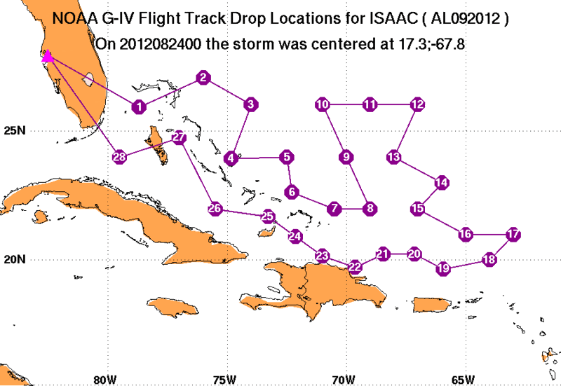
emcf30- Posts : 975
Reputation : 10
Join date : 2012-07-16
Age : 93
Re: The Atlantic Express - Tropical Storm Isaac - Tropical STorm Joyce- and New AOI
![]() by emcf30 Thu Aug 23, 2012 8:42 am
by emcf30 Thu Aug 23, 2012 8:42 am
» summer 2019 hurricane season
» April-May Florida weather and local events etc
» NASCAR 2019
» Late January through February outlook
» FLORIDA/ALABAMA AND THE HOLIDAY SEASON WEATHER
» NASCAR 2018
» CLOSED Florida/Alabama Blog - October Tropical Mischief