Latest topics
Florida Blog

Southeast Radar Loop

Kamala Severe Warnings

Warnings
WPC 5 Day Precip

Most Viewed Topics
Search
The Key for the South - The Southeast Ridge.
4 posters
Page 1 of 1

The Key for the South - The Southeast Ridge.
![]() by emcf30 Thu Jan 10, 2013 11:38 pm
by emcf30 Thu Jan 10, 2013 11:38 pm
As we all can attest to out current weather pattern, we are under the influence of the "Southeast Ridge". With temperatures at 80 and above for several day there is no immediate end in sight, or is there.
A couple of blogs back, my thinking the pattern change will begin to make its change.
From January 3rd blog.
A big rain event will occur in the South as we make the change to the colder pattern. That rain will come between Thursday, Jan. 10th and Saturday, Jan. 12th. How far South is unknown at the moment. Will have to keep an eye out for the potential of some Severe Weather even tho at the moment, not thinking it will be a big, wide spread issue.
A big Southern Snow? Too early to know for sure, but snow-lovers like me will be glued to the models and observations looking at the pattern between Saturday, Jan. 12th and Tuesday, Jan. 16th. If we’re going to get any (and it’s a big “if”), that looks like about as good a set-up as we could get. It is a long way off.
Let's look at this for a moment.
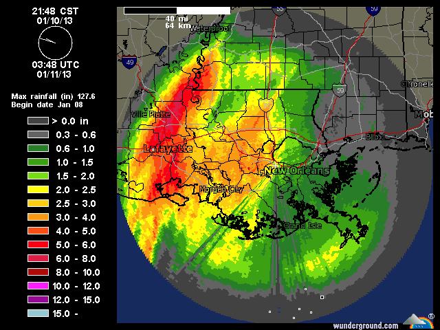
As we know, the rain event portion is panning out at the moment but was slightly faster by about 24 to 36 hours than I expected. Nonetheless, area in the Southern Plains and the deep south is receive tons of rain. Actually, I am impressed that the long range modeling nailed this event weeks ago.
Here is a snap shot of one of many areas that are affected.
Now comes the tricky part. This is where all the players comes into major play. My initial thinking was between January 12th through the 16th. I feel that is going to have to be backed up until the 18th or so. This is why.
The Southeast ridge.
This Southeast ridge has not allowed any cold weather into the Southeast. Expect this ridge to start breaking down in about 8 to 10 days. The models are in excellent agreement of this. If arctic air starts to move down into the plains and midwest, which seems likely at this point, I think we will see a gradual eastward and southward displacement of the SE ridge. Physically this makes sense, as the much colder and denser air can effectively beat the ridge down.
With the SSW and the corresponding Polar Vortex, everything is coming into play. Another thing, All indications point to the NAO and the AO turning negative in about ten days. This is what will drive the arctic air Southeastward. With the Southeast block being dislodged, and the trough of low pressure shifting off the West coast being replaced by ridging, anything can happen.
Here is the GFS for the 18th

And the Euro, showing the moisture.

This is the first step. There is once again, excellent model agreement in this between both the American and European Models and their Ensembles. In fact, the 12Z Euro shows the coldest day on the morning of the 21st with about 5 at Nashville, 9 at Huntsville, and 15 at Birmingham. At noon, it shows 17 Nashville, 22 Huntsville, and 25 in Birmingham. I don't care who you are this is cold.
Good blocking appears to be setting up. Without this blocking, the cold air could never make it South like what happened last year. It would be a flat pattern. The Polar Vortex would just move on to the East

Cold weather lovers just have to be patient. It is very confusing at the moment with the Southwest flow coming from the GOM at the moment. But this will change with time. Still to be determined where the ice event and the snow event separation will be around the 18th or so. My guess, along with others I have spoken with, will be the I-40. As we know, this will change back and forth several times. But until then, the warmth is on.
PEACE
A couple of blogs back, my thinking the pattern change will begin to make its change.
From January 3rd blog.
A big rain event will occur in the South as we make the change to the colder pattern. That rain will come between Thursday, Jan. 10th and Saturday, Jan. 12th. How far South is unknown at the moment. Will have to keep an eye out for the potential of some Severe Weather even tho at the moment, not thinking it will be a big, wide spread issue.
A big Southern Snow? Too early to know for sure, but snow-lovers like me will be glued to the models and observations looking at the pattern between Saturday, Jan. 12th and Tuesday, Jan. 16th. If we’re going to get any (and it’s a big “if”), that looks like about as good a set-up as we could get. It is a long way off.
Let's look at this for a moment.
As we know, the rain event portion is panning out at the moment but was slightly faster by about 24 to 36 hours than I expected. Nonetheless, area in the Southern Plains and the deep south is receive tons of rain. Actually, I am impressed that the long range modeling nailed this event weeks ago.
Here is a snap shot of one of many areas that are affected.
Now comes the tricky part. This is where all the players comes into major play. My initial thinking was between January 12th through the 16th. I feel that is going to have to be backed up until the 18th or so. This is why.
The Southeast ridge.
This Southeast ridge has not allowed any cold weather into the Southeast. Expect this ridge to start breaking down in about 8 to 10 days. The models are in excellent agreement of this. If arctic air starts to move down into the plains and midwest, which seems likely at this point, I think we will see a gradual eastward and southward displacement of the SE ridge. Physically this makes sense, as the much colder and denser air can effectively beat the ridge down.
With the SSW and the corresponding Polar Vortex, everything is coming into play. Another thing, All indications point to the NAO and the AO turning negative in about ten days. This is what will drive the arctic air Southeastward. With the Southeast block being dislodged, and the trough of low pressure shifting off the West coast being replaced by ridging, anything can happen.
Here is the GFS for the 18th
And the Euro, showing the moisture.
This is the first step. There is once again, excellent model agreement in this between both the American and European Models and their Ensembles. In fact, the 12Z Euro shows the coldest day on the morning of the 21st with about 5 at Nashville, 9 at Huntsville, and 15 at Birmingham. At noon, it shows 17 Nashville, 22 Huntsville, and 25 in Birmingham. I don't care who you are this is cold.
Good blocking appears to be setting up. Without this blocking, the cold air could never make it South like what happened last year. It would be a flat pattern. The Polar Vortex would just move on to the East
Cold weather lovers just have to be patient. It is very confusing at the moment with the Southwest flow coming from the GOM at the moment. But this will change with time. Still to be determined where the ice event and the snow event separation will be around the 18th or so. My guess, along with others I have spoken with, will be the I-40. As we know, this will change back and forth several times. But until then, the warmth is on.
PEACE

emcf30- Posts : 975
Reputation : 10
Join date : 2012-07-16
Age : 93
Re: The Key for the South - The Southeast Ridge.
![]() by emcf30 Fri Jan 11, 2013 6:43 am
by emcf30 Fri Jan 11, 2013 6:43 am
Today on Average is the coldest day of the year for Orlando!
emcf30- Posts : 975
Reputation : 10
Join date : 2012-07-16
Age : 93
Re: The Key for the South - The Southeast Ridge.
![]() by emcf30 Fri Jan 11, 2013 5:28 pm
by emcf30 Fri Jan 11, 2013 5:28 pm
A strong storm, (non tropical) almost superstorm is forecast by GFS and ECMWF to come off Japan coast and head toward the far western Aleutians between 4 and 6 days from now. The pressure really gets down there to 944 to 945 mb, which is important because this could really amplify the western Ridge, which in turn could determine how the cold Polar vortex gets disloged in Canada

Right on Target

**BREAKING**
Models are starting to converge on a winter storm late next week.
This my latest thoughts when looking at guidance and factoring climo model biases and temp profiles. This is not a forecast just a general idea of what could happen Jan 17-20
Also,
CFSv2 continues to suggest a colder than normal second half of winter!

The latest run of the GFS drops the MOTHERLOAD of cold into the eastern US in a fashion similar to January 1985 if you all remember that winter. These runs continue to drop the Polar Vortex further to the South with is due to the ongoing major stratospheric warming event and will be historic if it were to verify

Credit: WxEastern
Right on Target
**BREAKING**
Models are starting to converge on a winter storm late next week.
This my latest thoughts when looking at guidance and factoring climo model biases and temp profiles. This is not a forecast just a general idea of what could happen Jan 17-20
Also,
CFSv2 continues to suggest a colder than normal second half of winter!
The latest run of the GFS drops the MOTHERLOAD of cold into the eastern US in a fashion similar to January 1985 if you all remember that winter. These runs continue to drop the Polar Vortex further to the South with is due to the ongoing major stratospheric warming event and will be historic if it were to verify
Credit: WxEastern
Last edited by emcf30 on Fri Jan 11, 2013 5:34 pm; edited 2 times in total (Reason for editing : Forgot the A in Canada)
emcf30- Posts : 975
Reputation : 10
Join date : 2012-07-16
Age : 93

emcf30- Posts : 975
Reputation : 10
Join date : 2012-07-16
Age : 93
Re: The Key for the South - The Southeast Ridge.
![]() by gomexwx Sat Jan 12, 2013 7:02 am
by gomexwx Sat Jan 12, 2013 7:02 am
Watch for Gulf Low's...Snow on the Gulf Coast depends on Cold air being in place and a Gulf Low forming South of the Coast moving East .The NW sector of the Low is where you will find the chance of snow for the deep south...

gomexwx- Posts : 641
Reputation : 63
Join date : 2012-07-16
Location : On an Acre somewhere on the gulf Coast


sangria- Admin
- Posts : 2345
Reputation : 55
Join date : 2012-07-16
Re: The Key for the South - The Southeast Ridge.
![]() by StAugustineFL Sat Jan 12, 2013 8:15 am
by StAugustineFL Sat Jan 12, 2013 8:15 am
gomexwx wrote:Watch for Gulf Low's...Snow on the Gulf Coast depends on Cold air being in place and a Gulf Low forming South of the Coast moving East .The NW sector of the Low is where you will find the chance of snow for the deep south...
I'd like to see a gulf low develop sometime this season while there's enough cold air in place. I don't want a 1993 superstorm but it would be nice to see the coast get some snow.
Speaking of 1993 Superstorm:


StAugustineFL- Posts : 2231
Reputation : 64
Join date : 2012-07-17
Re: The Key for the South - The Southeast Ridge.
![]() by emcf30 Sat Jan 12, 2013 8:17 am
by emcf30 Sat Jan 12, 2013 8:17 am
On each run, the PV continues to move South. Last time this happened was 1985, I believe. Going to have to do some research


emcf30- Posts : 975
Reputation : 10
Join date : 2012-07-16
Age : 93
Re: The Key for the South - The Southeast Ridge.
![]() by StAugustineFL Sat Jan 12, 2013 8:40 am
by StAugustineFL Sat Jan 12, 2013 8:40 am
NWS Miami: LOOKING FURTHER OUT IN TIME, BOTH GFS AND ECMWF SHOW AN ARCTIC AIRMASS MOVING SOUTH INTO MONTANA/DAKOTAS AND MINNESOTA BY DAY 10/JAN 22 - A 1052MB ARCTIC HIGH. WHETHER OR NOT THIS AIRMASS PLUNGES ALL THE WAY THROUGH THE SOUTHEAST U.S./FLORIDA IS JUST TOO EARLY TO TELL, BUT SOMETHING TO WATCH FOR A POTENTIAL LATE JANUARY COLD SPELL.
StAugustineFL- Posts : 2231
Reputation : 64
Join date : 2012-07-17
Re: The Key for the South - The Southeast Ridge.
![]() by StAugustineFL Sat Jan 12, 2013 8:46 am
by StAugustineFL Sat Jan 12, 2013 8:46 am
NWS Minneapolis: PAST THE EXTENDED PERIOD...THE OVERALL PATTERN REMAINS FAVORABLE FOR A SIGNIFICANT ARCTIC OUTBREAK LATE NEXT WEEK...AND INTO THE FOLLOWING WEEK AS THICKNESS VALUES DROP TO BELOW 500DAM. IN TERMS OF 85H TEMPS...THESE DROP TO ARND -20 TO -40C. THIS COULD BE ONE OF THOSE TIMES WHERE THE TEMP MAY NOT RISE ABV ZERO FOR MOST OF THE FA...WITH LOWS DROPPING TO -20 TO -25F.
StAugustineFL- Posts : 2231
Reputation : 64
Join date : 2012-07-17
Re: The Key for the South - The Southeast Ridge.
![]() by emcf30 Sat Jan 12, 2013 10:23 pm
by emcf30 Sat Jan 12, 2013 10:23 pm
LOL, the models just keep getting colder and colder.
This is departure from normal.

This is departure from normal.
emcf30- Posts : 975
Reputation : 10
Join date : 2012-07-16
Age : 93
Re: The Key for the South - The Southeast Ridge.
![]() by StAugustineFL Sun Jan 13, 2013 7:39 am
by StAugustineFL Sun Jan 13, 2013 7:39 am
This is from my folks NWS office. Looks like lack of snowpack will keep temps up a couple of degrees if the cold spell verifies but still potential for -20+ temperatures.
LURKING JUST BEYOND THE SCOPE OF CURRENT LONG TERM IS TRANSITION TO
SIGNIFICANTLY COLDER AIR... AS HUDSON BAY VORTEX DIVES SOUTHWARD
THROUGH THE GREAT LAKES. THIS LOOKS TO DISLODGE CHUNK OF ARCTIC
AIR SENDING IT SOUTHWARD THROUGH THE REGION BY MON JAN 21ST /MARTIN
LUTHER KING DAY/. 00Z GFS AND HI-RES ECMWF REMAIN IN GOOD AGREEMENT
ON THIS SCENARIO... ALTHOUGH THEY DIFFER SOMEWHAT WITH MAGNITUDE OF
COLD AIR WITH GFS ADVERTISING 850 MB TEMPS OF -20 TO -25C ON MON WHILE
ECMWF EVEN MORE BRUTAL AT -30C TO -33C BY 00Z TUE. REGARDLESS...
UNLESS SOMETHING DRASTICALLY CHANGES WE ARE LOOKING AT AN EXTREMELY
COLD PERIOD AT LEAST FIRST HALF OF WEEK OF JAN 21-25TH... WITH THE
MAGNITUDE DIFFERENCE IN MODELS GENERALLY EQUATING TO WHETHER OR NOT
IT WILL BE RECORD BREAKING COLD. IF MEMORY SERVES CORRECT THE LAST
TIME WE`VE SEEN ANYTHING AS COLD AS SUGGESTED BY MODELS WAS JAN `09
WHEN THE MORNING OF JAN 16TH SEVERAL SITES TIED OR BROKE ALL TIME
JAN RECORD LOWS... WITH LOWS THAT MORNING DROPPING TO AROUND -30F IN
SOME AREAS. LOOKING AT THE 12Z/16TH 850 MB TEMPS THEY WERE AROUND
-20C OR A LITTLE COLDER. THE KEY WAS MUCH OF THE REGION WAS SITTING
ON 6 TO 12 INCHES OF SNOW COVER AFTER A COUPLE OF HEAVY SNOW EVENTS
JUST DAYS APART AND WITHIN A WEEK PRIOR TO THE 16TH. SO... UNLESS
SOMETHING DRAMATICALLY AND TERRIBLY UNFORESEEN OCCURS WITHOUT THE DEEP
SNOWCOVER WILL LIKELY NOT BE SEEING ANY RECORD COLD POTENTIAL... THAT
IS... UNLESS THE HI-RES ECMWF WERE TO MAINTAIN 850 MB TEMPS OF -30C
TO -33C INTO TUE MORNING. THESE 850 MB TEMPS FROM ECMWF IN JUST THE
PRESENCE OF WEAK SFC RIDGING... LIGHT WINDS AND MAINLY CLEAR SKIES
WOULD SUPPORT LOWS NEAR TO ROUGHLY 3 DEGS BELOW THE PROGGED 850 MB
TEMPS... OR GENERALLY NEAR RECORD COLD LEVELS OF AROUND -20F TO -27F.
StAugustineFL- Posts : 2231
Reputation : 64
Join date : 2012-07-17
Re: The Key for the South - The Southeast Ridge.
![]() by sangria Tue Jan 15, 2013 7:28 pm
by sangria Tue Jan 15, 2013 7:28 pm
I know this a long way out.......but the 12Z GFS is really pushing it....

sangria- Admin
- Posts : 2345
Reputation : 55
Join date : 2012-07-16
Re: The Key for the South - The Southeast Ridge.
![]() by sangria Thu Jan 17, 2013 7:39 am
by sangria Thu Jan 17, 2013 7:39 am
Current Watches/Warnings, across SE And Mid Atlantic....as of 6:30AM EST....


sangria- Admin
- Posts : 2345
Reputation : 55
Join date : 2012-07-16

sangria- Admin
- Posts : 2345
Reputation : 55
Join date : 2012-07-16

sangria- Admin
- Posts : 2345
Reputation : 55
Join date : 2012-07-16
» summer 2019 hurricane season
» April-May Florida weather and local events etc
» NASCAR 2019
» Late January through February outlook
» FLORIDA/ALABAMA AND THE HOLIDAY SEASON WEATHER
» NASCAR 2018
» CLOSED Florida/Alabama Blog - October Tropical Mischief