


One after another and another:
Page 1 of 4 • 1, 2, 3, 4 ![]()

One after another and another:
![]() by emcf30 Tue Feb 05, 2013 10:47 pm
by emcf30 Tue Feb 05, 2013 10:47 pm

As anticipated, the recent Severe Weather outbreak in the South was the key to the door to open the flood gates of the current ongoing and future weather patterns. Small waves of energy or Clipper style events coming through the Mid-West have been bringing 1 to 2 inches of snow to parts of the South every other day, it seems like. There have been some areas that have received 4 to 6 inches from these clippers from the Cumberland Plateau to the East to the Appalachians.
Beginning Friday into Saturday an Alberta Clipper will be moving out of Canada and should merge with an area of Low Pressure moving in from the South. This phased system will rapidly deepen and could bring heavy snow to portions of the mid-Atlantic and New England.
The end of the week clipper follows a number of systems
But most importantly, this is setting the stage for a potentially much more potent event in the coming days. More specifically around Valentines Day.
Lets break it down.

The Setup, beginning today.
There will be a series of weaker short wave troughs of waves of energy that will develop over Mexico and Texas and should move to the East towards the Lower Mississippi Valley. My current thinking is that these waves of energy will follow a very slow moving cold fronts that with the first one this weekend creeping along the Georgia-Florida border. This front will slowly work its way the the South and clear Florida over the weekend. Additional fronts will come into play as well as more areas of low pressure.

The GFS and EURO are gaining confidence and both are slowly increasing the odds that we will see a decent storm in the days around Valentines Day. The mechanism by which the two models arrive at this storm differs somewhat. The Euro holds more energy back over the central Plains around hr180, phasing it in to the southern stream energy that comes in through Mexico to TX track heading East. The GFS on the other hand, derives whatever gets trapped in the southern jet from northern stream energy diving deep in to the inter mountain west, then splitting it off. Euro leaving the energy back in the central plains prevents to some extent any chance for a suppressed system, which results in a positive oriented trough at 192, as even more energy is coming down through the Great Lakes, stringing the wave out. Irregardless, if you were to take a mean of the H5 energy on both of these models, and their Ensembles, you would have a pretty decent East Coast storm.


The Rain.
If you look at the precipitation maps from NOAA and the HPC, it is pretty obvious where they think the trough alignment and the surface low pressure area will be.


There will be some beneficial rains for some peeps and a bit much for others.
How will it happen.
It looks like this may be our first February Severe Weather threat. The models have been consistent in showing a stalled out cold front in the South. After sitting stationary for awhile, it will begin to move North as a warm front. A developing potent surface low will ride along the boundary pulling in ample lo level deep moisture from the GOM with it. The euro is little less robust but its trended more towards the GFS after last nights 0z run. The CMC is pretty nasty for Dixie Alley. Dew points looks to get into at least the low 60s up far North as Southern Tennessee.
There are a number of Severe Weather markers that are being presented.
1. Surface base cape at 750Jkg and higher (sometimes as high as 1750Jkg) across a large area in the lower Mississippi Valley.
2. The track of the surface low is consistent with favorable tracks for severe thunderstorm events in the lower Mississippi Valley.
3. Surface low has strengthened greatly over the last several model runs and has shown a trend to keep strengthening.
4. Significant low-level shear noted on forecast soundings in Mississippi.
5. The worst run in terms of shear and surface low strength has came in within truncation hours.
6. The dew point are becoming higher and higher ahead of the low with each run.
Another very important thing to watch is a Wedge that is being shown in the various models for Atlanta to the North. This is a very important feature. This is why;
Wedge interactions can "kill" severe threat as the air is much more stable. HOWEVER, history shows us time after time that discrete cells interacting with the edge/boundary of the wedge can rapidly intensify and travel along the edge/boundary. These cell often become very violent tornadic super-cells and can cause a lot of damage. Really all of North Georgia needs to watch out. The latest run breaks down the wedge much earlier. Could be quite problematic given the 750j/kg CAPE it works into pretty much the entire area too. Couple that with some 60kt bulk shear (40-60kt 850mb shear) and BOOM. Then after 177 it says "bye bye wedge", jacks the 60º DP line into TN, draws in CAPE of 750+ to TN, with 1000+ across central/southern AL.
Hangs a LOT of energy out west. This is important for the backside of the low.
One thought is that this sub 998mb low will continue to deepen then phase with energy coming down from the North. This phasing of low pressure should transfer along the East Coast of Georgia and Carolina and move to the North. The final track will depend on how much blocking is in place. If it moves up the East Coast, the odds are that it will deepen further and become a very decent event all up the Eastern Seaboard.
The Cold Side
Energy is shown to be hanging out after the low moves out dragging an Arctic Front. With cold air coming into the region, bands of heavy snow could develop in the deep and mid South. The thing to watch out for is the Deformation bands that should develop. We will pin point these areas down closer to the event. On the other hand Cold Air Damming, CAD my set up in some areas. There may be some freezing rain to contend with also. It will be very close form a cold rain to freezing rain further South of the snow areas because of this. But 1 to 2 degree drop in temps will make a huge difference in this set up. So point being at the moment, it is to early to pin point down the exacts with this system because it is very complicated.
The latest GFS Ensembles shows a series of classic Miller A and South East coastal lows in the V-day and beyond period. One after another after another. Interesting
Stay tuned

emcf30- Posts : 975
Reputation : 10
Join date : 2012-07-16
Age : 93
Re: One after another and another:
![]() by emcf30 Tue Feb 05, 2013 10:53 pm
by emcf30 Tue Feb 05, 2013 10:53 pm
emcf30- Posts : 975
Reputation : 10
Join date : 2012-07-16
Age : 93

scouter534- Posts : 128
Reputation : 1
Join date : 2012-07-16
Age : 62
Location : Pompano Beach, FL
Re: One after another and another:
![]() by sangria Wed Feb 06, 2013 8:34 am
by sangria Wed Feb 06, 2013 8:34 am

sangria- Admin
- Posts : 2345
Reputation : 55
Join date : 2012-07-16
Re: One after another and another:
![]() by sangria Wed Feb 06, 2013 8:45 am
by sangria Wed Feb 06, 2013 8:45 am
There is no way to create a "draft" in the original "topic" post. The function is available, when someone is posting a "reply." I think that has happened before, as well.......so, maybe the best thing to do, is to create a new "topic," with a title name.......... and then "post a reply" for all of the data, to be put in the topic post...... this way you can save it, as a draft, and work on it, as you would like.
Does that make sense? The "draft" button is at the bottom, in the "post a reply" area....

sangria- Admin
- Posts : 2345
Reputation : 55
Join date : 2012-07-16
Re: One after another and another:
![]() by StAugustineFL Wed Feb 06, 2013 8:58 am
by StAugustineFL Wed Feb 06, 2013 8:58 am
BY DAY 3 A WINTER STORM WITH POTENTIALLY SIGNIFICANT IMPACTS IS
EXPECTED TO BEGIN EVOLVING ACROSS THE NORTHEASTERN U.S. MODELS
SHOW THE NORTHERN STREAM WAVE CONTINUING TO THE EAST ACROSS THE
EASTERN GREAT LAKES REGION INTO THE NORTHEAST BY LATE
FRI...PHASING WITH A SOUTHERN STREAM SHORTWAVE LIFTING NORTH ALONG
THE EASTERN SEABOARD...RESULTING IN A DEEP SURFACE CYCLONE
TRACKING ALONG THE MID ATLANTIC TO THE NORTHEAST COASTS FRI NIGHT
INTO SAT. HEAVY PRECIPITATION IN THE ASSOCIATED DEFORMATION ZONE
PRODUCING HEAVY SNOW ACCUMULATIONS IS POSSIBLE ALONG THE NORTHERN
MID ATLANTIC TO NEW ENGLAND COASTS. WHILE HEAVY SNOWS FOR AT
LEAST SOME PORTIONS OF THE NORTHEAST APPEAR QUITE LIKELY...MODEL
SPREAD AS OUTLINED IN THE PMDHMD PRECLUDES PINPOINTING THOSE AREAS
WITH ANY DEGREE OF CERTAINTY AT THIS POINT.

StAugustineFL- Posts : 2231
Reputation : 64
Join date : 2012-07-17
Re: One after another and another:
![]() by sangria Wed Feb 06, 2013 9:58 am
by sangria Wed Feb 06, 2013 9:58 am
sangria- Admin
- Posts : 2345
Reputation : 55
Join date : 2012-07-16
Re: One after another and another:
![]() by Swiss Miss Wed Feb 06, 2013 10:29 am
by Swiss Miss Wed Feb 06, 2013 10:29 am
sangria wrote:Please excuse, if this is "off topic"...... BUT, it IS rain ! TIA
LMAO Get back to work!!

Swiss Miss- Posts : 291
Reputation : 2
Join date : 2012-09-07
Age : 56 -

Re: One after another and another:
![]() by StAugustineFL Wed Feb 06, 2013 11:06 am
by StAugustineFL Wed Feb 06, 2013 11:06 am

StAugustineFL- Posts : 2231
Reputation : 64
Join date : 2012-07-17

StAugustineFL- Posts : 2231
Reputation : 64
Join date : 2012-07-17
Re: One after another and another:
![]() by emcf30 Wed Feb 06, 2013 9:51 pm
by emcf30 Wed Feb 06, 2013 9:51 pm

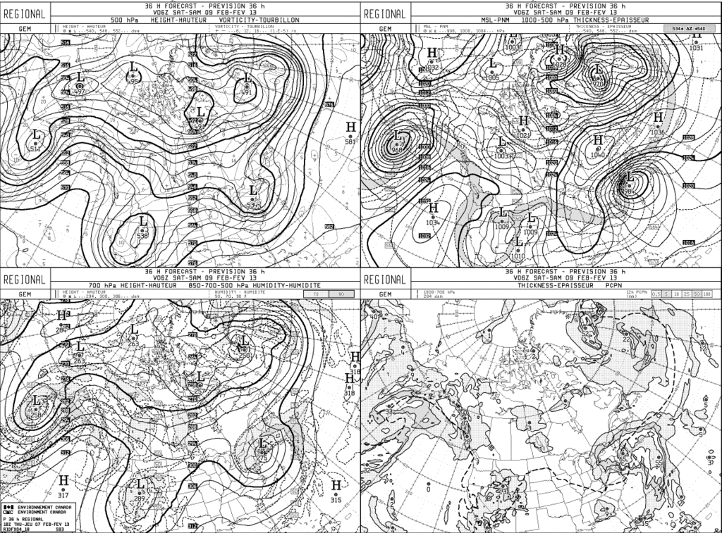
Notice the 540 dip
emcf30- Posts : 975
Reputation : 10
Join date : 2012-07-16
Age : 93

emcf30- Posts : 975
Reputation : 10
Join date : 2012-07-16
Age : 93
Re: One after another and another:
![]() by emcf30 Wed Feb 06, 2013 9:54 pm
by emcf30 Wed Feb 06, 2013 9:54 pm

emcf30- Posts : 975
Reputation : 10
Join date : 2012-07-16
Age : 93
Re: One after another and another:
![]() by emcf30 Wed Feb 06, 2013 9:58 pm
by emcf30 Wed Feb 06, 2013 9:58 pm
Posted Image

emcf30- Posts : 975
Reputation : 10
Join date : 2012-07-16
Age : 93
Re: One after another and another:
![]() by emcf30 Wed Feb 06, 2013 10:00 pm
by emcf30 Wed Feb 06, 2013 10:00 pm
emcf30- Posts : 975
Reputation : 10
Join date : 2012-07-16
Age : 93
Re: One after another and another:
![]() by StAugustineFL Thu Feb 07, 2013 9:31 am
by StAugustineFL Thu Feb 07, 2013 9:31 am
(3) A third storm will develop during the middle of next week. This one should work along the stalled front north of the First Coast from storm #2 (see above). Early indications are that this will be a significant weather system with the potential for a severe storm outbreak over much of the Southeast U.S. & heavy snow for parts of the Tennessee & Ohio Valley to the east coast (depending, of course, on the exact track of the storm).
StAugustineFL- Posts : 2231
Reputation : 64
Join date : 2012-07-17
Re: One after another and another:
![]() by sangria Thu Feb 07, 2013 10:29 am
by sangria Thu Feb 07, 2013 10:29 am
sangria- Admin
- Posts : 2345
Reputation : 55
Join date : 2012-07-16


sangria- Admin
- Posts : 2345
Reputation : 55
Join date : 2012-07-16
Re: One after another and another:
![]() by sangria Thu Feb 07, 2013 12:12 pm
by sangria Thu Feb 07, 2013 12:12 pm

sangria- Admin
- Posts : 2345
Reputation : 55
Join date : 2012-07-16
Re: One after another and another:
![]() by StAugustineFL Thu Feb 07, 2013 12:30 pm
by StAugustineFL Thu Feb 07, 2013 12:30 pm
sangria wrote:Hey Aug....I wonder if your met is referring to what might be ANOTHER storm, around the 17th-18th?
Nope, the one middle of next week. There'll be a weaker system moving out of the Rockies into the Great Lakes Sun/Mon. That's the second system he was referring to which will have no impact on us in FL.
StAugustineFL- Posts : 2231
Reputation : 64
Join date : 2012-07-17
Re: One after another and another:
![]() by sangria Thu Feb 07, 2013 1:10 pm
by sangria Thu Feb 07, 2013 1:10 pm
#1

#2

#3

and what I'm guessing could be #4 (although, it is 264 hours out)

Last edited by sangria on Thu Feb 07, 2013 4:22 pm; edited 1 time in total (Reason for editing : incorrect image)
sangria- Admin
- Posts : 2345
Reputation : 55
Join date : 2012-07-16
Re: One after another and another:
![]() by emcf30 Thu Feb 07, 2013 4:32 pm
by emcf30 Thu Feb 07, 2013 4:32 pm
StAugustineFL wrote:sangria wrote:Hey Aug....I wonder if your met is referring to what might be ANOTHER storm, around the 17th-18th?
Nope, the one middle of next week. There'll be a weaker system moving out of the Rockies into the Great Lakes Sun/Mon. That's the second system he was referring to which will have no impact on us in FL.
The 17th time frame will most likely be a decent storm Aug. There may be several of them in a row.
emcf30- Posts : 975
Reputation : 10
Join date : 2012-07-16
Age : 93

emcf30- Posts : 975
Reputation : 10
Join date : 2012-07-16
Age : 93
Re: One after another and another:
![]() by emcf30 Thu Feb 07, 2013 4:41 pm
by emcf30 Thu Feb 07, 2013 4:41 pm
NATIONAL WEATHER SERVICE TAUNTON MA
355 PM EST THU FEB 7 2013
...A POTENTIAL HISTORIC WINTER STORM AND BLIZZARD IS EXPECTED TO
DROP AROUND 2 FEET OF SNOW FRIDAY INTO SATURDAY...
MAZ005>007-012>023-RIZ001>008-080500-
/O.UPG.KBOX.BZ.A.0001.130208T1200Z-130209T2100Z/
/O.NEW.KBOX.BZ.W.0001.130208T1100Z-130209T1800Z/
CENTRAL MIDDLESEX MA-WESTERN ESSEX MA-EASTERN ESSEX MA-
SOUTHERN WORCESTER MA-WESTERN NORFOLK MA-SOUTHEAST MIDDLESEX MA-
SUFFOLK MA-EASTERN NORFOLK MA-NORTHERN BRISTOL MA-
WESTERN PLYMOUTH MA-EASTERN PLYMOUTH MA-SOUTHERN BRISTOL MA-
SOUTHERN PLYMOUTH MA-BARNSTABLE MA-DUKES MA-
NORTHWEST PROVIDENCE RI-SOUTHEAST PROVIDENCE RI-WESTERN KENT RI-
EASTERN KENT RI-BRISTOL RI-WASHINGTON RI-NEWPORT RI-
BLOCK ISLAND RI-
INCLUDING THE CITIES OF...FRAMINGHAM...LOWELL...LAWRENCE...
GLOUCESTER...MILFORD...WORCESTER...FOXBORO...NORWOOD...
CAMBRIDGE...BOSTON...QUINCY...TAUNTON...BROCKTON...PLYMOUTH...
FALL RIVER...NEW BEDFORD...MATTAPOISETT...CHATHAM...FALMOUTH...
PROVINCETOWN...VINEYARD HAVEN...FOSTER...SMITHFIELD...
PROVIDENCE...WEST GREENWICH...WARWICK...BRISTOL...NARRAGANSETT...
WESTERLY...NEWPORT...BLOCK ISLAND
355 PM EST THU FEB 7 2013
...BLIZZARD WARNING FROM 6 AM FRIDAY TO 1 PM EST SATURDAY...
* LOCATIONS...EASTERN AND SOUTHEASTERN MASSACHUSETTS...INCLUDING
BOSTON AND BOSTON METRO AREA...ALL OF RHODE ISLAND INCLUDING
BLOCK ISLAND.
* HAZARD TYPES...HEAVY SNOW...BLOWING AND DRIFTING AT TIMES...
QUARTER MILE VISIBILITIES...AND WINDS GUSTING IN EXCESS OF 30 MPH.
* ACCUMULATIONS...SNOW ACCUMULATION OF 18 TO 24 INCHES.
* TIMING...LIGHT SNOW WILL DEVELOP BY FRIDAY MORNING...BECOMING
HEAVY LATE IN THE DAY INTO THE EVENING COMMUTE. THE HEAVIEST OF
SNOWFALL...ESPECIALLY FOCUS ALONG THE I-95 CORRIDOR...WILL FALL
FRIDAY NIGHT INTO SATURDAY.
* IMPACTS...BLIZZARD CONDITIONS AND DANGEROUS TRAVEL. WHITE OUT
CONDITIONS ARE ANTICIPATED AS ROADS BECOME SNOW COVERED BY THE
FRIDAY EVENING COMMUTE. STRONG NORTH-NORTHEAST WINDS ARE
ANTICIPATED WITH GUSTS UP TO AROUND 60 MPH...RESULTING IN
BLOWING AND DRIFTING OF SNOW. DAMAGE TO TREES AND STRUCTURES
ALONG WITH SCATTERED POWER OUTAGES ARE ANTICIPATED.
* WINDS...NORTHEAST 30 TO 40 MPH WITH GUSTS UP TO 65 MPH.
* VISIBILITIES...ONE QUARTER MILE OR LESS AT TIMES.
* TEMPERATURES...IN THE MID 20S.
PRECAUTIONARY/PREPAREDNESS ACTIONS...
A BLIZZARD WARNING IS ISSUED WHEN SUSTAINED WINDS OR FREQUENT
GUSTS OVER 35 MPH ARE EXPECTED WITH CONSIDERABLE FALLING AND/OR
BLOWING AND DRIFTING SNOW. VISIBILITIES WILL BECOME POOR WITH
WHITEOUT CONDITIONS AT TIMES. THOSE VENTURING OUTDOORS MAY
BECOME LOST OR DISORIENTED...SO PERSONS IN THE WARNING AREA ARE
ADVISED TO STAY INDOORS.
emcf30- Posts : 975
Reputation : 10
Join date : 2012-07-16
Age : 93
emcf30- Posts : 975
Reputation : 10
Join date : 2012-07-16
Age : 93
emcf30- Posts : 975
Reputation : 10
Join date : 2012-07-16
Age : 93
Re: One after another and another:
![]() by emcf30 Thu Feb 07, 2013 4:43 pm
by emcf30 Thu Feb 07, 2013 4:43 pm
URGENT - WINTER WEATHER MESSAGE
NATIONAL WEATHER SERVICE NEW YORK NY
355 PM EST THU FEB 7 2013
...MAJOR WINTER STORM TO IMPACT THE TRI-STATE AREA FRIDAY INTO
SATURDAY...
CTZ005-009-080500-
/O.UPG.KOKX.WS.A.0001.130208T1800Z-130209T1800Z/
/O.NEW.KOKX.BZ.W.0001.130208T1100Z-130209T1800Z/
NORTHERN FAIRFIELD-SOUTHERN FAIRFIELD-
355 PM EST THU FEB 7 2013
...BLIZZARD WARNING IN EFFECT FROM 6 AM FRIDAY TO 1 PM EST
SATURDAY...
THE NATIONAL WEATHER SERVICE IN UPTON HAS ISSUED A BLIZZARD
WARNING...WHICH IS IN EFFECT FROM 6 AM FRIDAY TO 1 PM EST
SATURDAY.
* LOCATIONS...SOUTHERN FAIRFIELD COUNTY.
* HAZARD TYPES...HEAVY SNOW AND STRONG WINDS.
* ACCUMULATIONS...SNOW ACCUMULATION OF 18 TO 24 INCHES.
* WINDS...NORTHEAST 15 TO 25 MPH WITH GUSTS UP TO 45 MPH.
* TEMPERATURES...FALLING IT NO THE 20S FRIDAY EVENING.
* VISIBILITIES...ONE QUARTER MILE OR LESS AT TIMES.
* TIMING...THE STRONGEST WINDS AND HEAVIEST SNOW WILL OCCUR FRIDAY
EVENING INTO SATURDAY MORNING.
* IMPACTS...HEAVY SNOW AND WINDS WILL MAKE FOR DANGEROUS DRIVING
CONDITIONS WITH VISIBILITIES NEAR ZERO IN WHITE-OUT CONDITIONS.
IN ADDITION...SOME TREE LIMBS WILL BE DOWNED...CAUSING SCATTERED
POWER OUTAGES.
PRECAUTIONARY/PREPAREDNESS ACTIONS...
A BLIZZARD WARNING MEANS SEVERE WINTER WEATHER CONDITIONS ARE
EXPECTED OR OCCURRING. FALLING AND BLOWING SNOW WITH STRONG WINDS
AND POOR VISIBILITIES ARE LIKELY. THIS WILL LEAD TO WHITEOUT
CONDITIONS...MAKING TRAVEL EXTREMELY DANGEROUS. DO NOT TRAVEL. IF
YOU MUST TRAVEL...HAVE A WINTER SURVIVAL KIT WITH YOU. IF YOU GET
STRANDED...STAY WITH YOUR VEHICLE.
emcf30- Posts : 975
Reputation : 10
Join date : 2012-07-16
Age : 93
Re: One after another and another:
![]() by emcf30 Thu Feb 07, 2013 4:45 pm
by emcf30 Thu Feb 07, 2013 4:45 pm

emcf30- Posts : 975
Reputation : 10
Join date : 2012-07-16
Age : 93
Re: One after another and another:
![]() by emcf30 Thu Feb 07, 2013 4:47 pm
by emcf30 Thu Feb 07, 2013 4:47 pm

emcf30- Posts : 975
Reputation : 10
Join date : 2012-07-16
Age : 93
Re: One after another and another:
![]() by emcf30 Thu Feb 07, 2013 4:52 pm
by emcf30 Thu Feb 07, 2013 4:52 pm

Prolly about a 3 foot storm surge with this


emcf30- Posts : 975
Reputation : 10
Join date : 2012-07-16
Age : 93
Re: One after another and another:
![]() by emcf30 Fri Feb 08, 2013 6:15 am
by emcf30 Fri Feb 08, 2013 6:15 am
CLICK TO ANIMATE

emcf30- Posts : 975
Reputation : 10
Join date : 2012-07-16
Age : 93
Re: One after another and another:
![]() by emcf30 Fri Feb 08, 2013 6:21 am
by emcf30 Fri Feb 08, 2013 6:21 am

emcf30- Posts : 975
Reputation : 10
Join date : 2012-07-16
Age : 93
Re: One after another and another:
![]() by sangria Fri Feb 08, 2013 6:30 am
by sangria Fri Feb 08, 2013 6:30 am
sangria- Admin
- Posts : 2345
Reputation : 55
Join date : 2012-07-16
Re: One after another and another:
![]() by emcf30 Fri Feb 08, 2013 6:30 am
by emcf30 Fri Feb 08, 2013 6:30 am
http://content.wdtinc.com/popout/index.php?M=14613&C=20643&O=10190
emcf30- Posts : 975
Reputation : 10
Join date : 2012-07-16
Age : 93
Re: One after another and another:
![]() by emcf30 Fri Feb 08, 2013 6:32 am
by emcf30 Fri Feb 08, 2013 6:32 am
emcf30- Posts : 975
Reputation : 10
Join date : 2012-07-16
Age : 93

emcf30- Posts : 975
Reputation : 10
Join date : 2012-07-16
Age : 93
Re: One after another and another:
![]() by gomexwx Fri Feb 08, 2013 9:15 am
by gomexwx Fri Feb 08, 2013 9:15 am
WordPad is your friend.

gomexwx- Posts : 641
Reputation : 63
Join date : 2012-07-16
Location : On an Acre somewhere on the gulf Coast

sangria- Admin
- Posts : 2345
Reputation : 55
Join date : 2012-07-16
Re: One after another and another:
![]() by sangria Fri Feb 08, 2013 2:17 pm
by sangria Fri Feb 08, 2013 2:17 pm
Streaming Live by Ustream
sangria- Admin
- Posts : 2345
Reputation : 55
Join date : 2012-07-16
Mega Blizzard Update. What lies in the future for the South.
![]() by emcf30 Fri Feb 08, 2013 6:12 pm
by emcf30 Fri Feb 08, 2013 6:12 pm
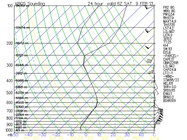
The answer is simple if you’re in New England tonight, but it’s not so easy in Alabama or Tennessee down the road. A nor’easter working up the East Coast could dump as much as 24 to 40 inches of snow tonight and Saturday in Massachusetts north through southern Maine. This is the latest warning advisory map for the NWS in Taunton, Massachusetts (that’s the Boston office):

This monster storm system whipping up hurricane force winds along the coast and dumping feet of snow will strengthen a north-northeast wind coming from a dry, cool air mass just north of the Tennessee Valley on Saturday. That translates to a sunny, mild afternoon that feels a little cool if you’re out in the breeze. A strong area of high pressure just west of the nor’easter blocks the stormy weather west of us for a day:

What happens after Saturday starts to get interesting for the rest of our extended forecast period as well as the rest of the month to be honest.
Cant post every map that backs up a cold/snow threats for the South and specifically the Tennessee Valley over the next few weeks, but here are some of the basics at the moment
:
Sunday to Tuesday: Rain is the big weather story. Some cold air will move in behind the first batch of wet weather on Monday, but it will not get cold enough for a winter weather worry. Some of the peeps in the South may have to deal with flooding; up to 5 or 6 inches of rain are possible on the high end, but most will be in the 2-3 inch range between Sunday and Tuesday.
Wednesday: This is the first chance of wintry precipitation over the next 2 weeks. It looks minor at best, and will probably be a non-event for North Alabama and Southern Tennessee; however, snow rarely shows it’s hand more than 48 hours in advance (sometimes not even 12 hours in advance)! That means we will keep an eye on it and adjust accordingly. Right now, all you should expect in our little corner of the Tennessee Valley is some light to moderate rain Wednesday with a chance of it turning over to some mixture or light snow as it ends. Temperatures will be above freezing, so whatever falls will have the same impact as rain for them
Here’s the GFS output for snow accumulation through 6 AM Wednesday morning; it indicates a tiny, tiny amount of snow coming east from Oklahoma toward Middle Tennessee. On a scale of 1-10 (1 being “spitting snow” and 10 being the nor’easter impacting New England), this would be around a 1 or 2 – not a big deal. We’ll be watching for any surprises! Just FYI, the Canadian model is much more aggressive with snow, but the European look is practically snow-less. Like I said, adjustments may be necessary as this system “shows it’s hand.”

San, this may answer you question for the 18th
Beyond Wednesday and the Seven Day Forecast: A wise man (Dr. Charles Wax) once said “anything past three days is magic” when referring to a weather forecast. I like to think we’ve gotten a little better with the over-all pattern since he formed that opinion in the 80s and 90s, but he’s right when it comes to local specifics. That’s why when you see a map like this one for next Saturday night, you should understand the uncertainty involved:

On the left, you see the “operational run,” and on the right the “ensemble spaghetti plot.” See how a lot of those blue lines on the spaghetti plot mirror the pattern in the operational run? That’s pretty good confidence that (1) it will get much colder and (2) there could be a chance of wintry weather in the Deep South and Tennessee Valley next weekend.
So what are the odds? Historically, this is the kind of set-up you’d look for if you’re going to find heavy snow that lasts a few days on the ground in Mississippi, Tennessee, Alabama and Georgia – especially the I-20/59 corridors. Is it likely? Not 100% on that. Is it possible. Definitely. Got 8 days to watch it set up
Dr. Wax’s words always come to mind when looking at things like this. It’s a possibility, but anyone that tells you that it definitely will or won’t happen is practicing something other than science. On the other hand, if you read the atmosphere, the signs and signals, and with the updated modeling, it does give you a good hint of a general scenario. Once again one after another and another and another. Things are changing. Stay tuned for exciting times!
emcf30- Posts : 975
Reputation : 10
Join date : 2012-07-16
Age : 93
Re: One after another and another:
![]() by sangria Fri Feb 08, 2013 6:27 pm
by sangria Fri Feb 08, 2013 6:27 pm
In the time period, before that, I read some comments about "GOM freeze" next weekend.....any thoughts, on how far the cold will reach?
sangria- Admin
- Posts : 2345
Reputation : 55
Join date : 2012-07-16
Re: One after another and another:
![]() by emcf30 Fri Feb 08, 2013 6:37 pm
by emcf30 Fri Feb 08, 2013 6:37 pm
emcf30- Posts : 975
Reputation : 10
Join date : 2012-07-16
Age : 93
Re: One after another and another:
![]() by emcf30 Fri Feb 08, 2013 8:30 pm
by emcf30 Fri Feb 08, 2013 8:30 pm
http://rapidrefresh.noaa.gov/HRRR/Welcome.cgi?dsKey=hrrr_jet&domain=t3&run_time=08+Feb+2013+-+19Z

emcf30- Posts : 975
Reputation : 10
Join date : 2012-07-16
Age : 93


emcf30- Posts : 975
Reputation : 10
Join date : 2012-07-16
Age : 93
Re: One after another and another:
![]() by emcf30 Fri Feb 08, 2013 8:38 pm
by emcf30 Fri Feb 08, 2013 8:38 pm
emcf30- Posts : 975
Reputation : 10
Join date : 2012-07-16
Age : 93
emcf30- Posts : 975
Reputation : 10
Join date : 2012-07-16
Age : 93

emcf30- Posts : 975
Reputation : 10
Join date : 2012-07-16
Age : 93
Re: One after another and another:
![]() by emcf30 Fri Feb 08, 2013 8:48 pm
by emcf30 Fri Feb 08, 2013 8:48 pm
North Banford, CT has already reported 13 inches of snow.
emcf30- Posts : 975
Reputation : 10
Join date : 2012-07-16
Age : 93

emcf30- Posts : 975
Reputation : 10
Join date : 2012-07-16
Age : 93
Re: One after another and another:
![]() by emcf30 Fri Feb 08, 2013 10:22 pm
by emcf30 Fri Feb 08, 2013 10:22 pm
emcf30- Posts : 975
Reputation : 10
Join date : 2012-07-16
Age : 93
Page 1 of 4 • 1, 2, 3, 4 ![]()


» summer 2019 hurricane season
» April-May Florida weather and local events etc
» NASCAR 2019
» Late January through February outlook
» FLORIDA/ALABAMA AND THE HOLIDAY SEASON WEATHER
» NASCAR 2018
» CLOSED Florida/Alabama Blog - October Tropical Mischief