Latest topics
Florida Blog

Southeast Radar Loop

Kamala Severe Warnings

Warnings
WPC 5 Day Precip

Most Viewed Topics
Search
Next Trouble Maker
4 posters
Page 1 of 2
Page 1 of 2 • 1, 2 ![]()

Next Trouble Maker
![]() by emcf30 Fri Feb 22, 2013 9:05 pm
by emcf30 Fri Feb 22, 2013 9:05 pm
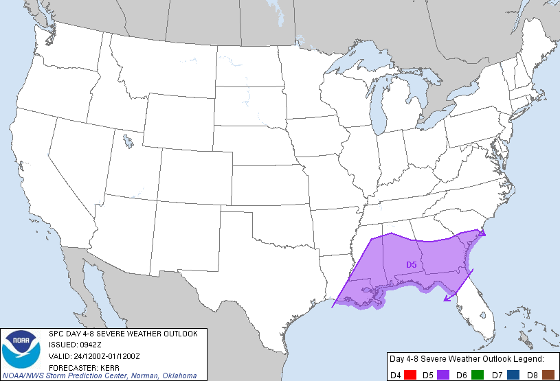
And the saga continues across the U.S. of A. The next system with it's sights set on the CONUS is in the making. This time, the immediate Gulf Coast States WILL be threatened. Here is the set up.
Lets look at the current data.
We have to look out West once again for the set up. Currently, a strong upper level disturbance is moving onshore from the pacific.

By tomorrow, the ULL will be somewhere in this area. This ULL will move to the SE.

On Monday, a subtropical jet will set up and a surface Low could develop anywhere from the Northern GOM to Georgia. Just a thought even though none of the major models really consistently show this, the signs kinda lean towards it. I probably will be wrong. But, if it happened, this will feed the warm moist flow into a are that the sub-tropical jet will be creating havoc as far as severe weather goes in the deep South.

You can see the two (2) pieces of energy on the NAM simulated radar.

You can see the flow that is setting up for the ULL to travel

So with this Split Flow, Trouble cometh

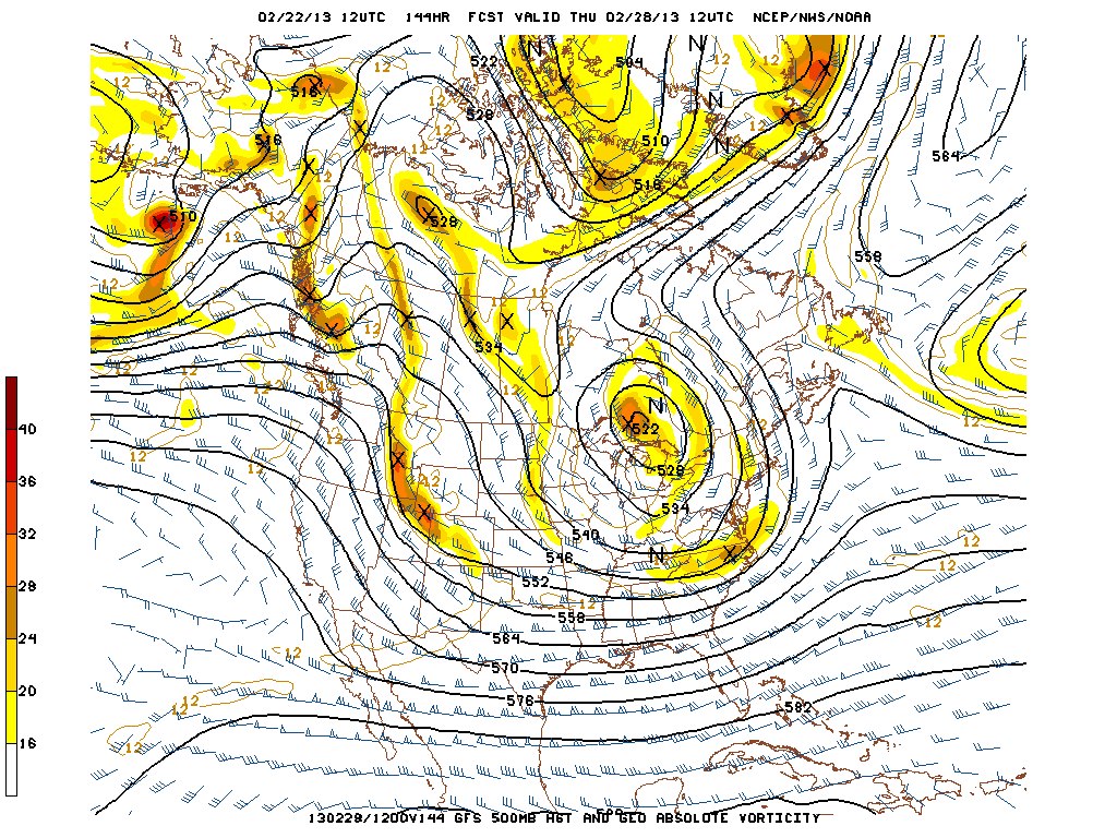
...DISCUSSION...
MONDAY /DAY 4/...MODEL CONSENSUS IS THAT VIGOROUS SHORTWAVE TROUGH
WILL EJECT FROM THE SRN/CNTRL PLAINS MONDAY MORNING TO THE TN/OH
VALLEYS 12Z TUESDAY. ATTENDANT SFC LOW WILL OCCLUDE OVER THE MID MS
AND OH VALLEYS...WHILE SECONDARY CYCLOGENESIS IS FORECAST FROM SRN
GA TO COASTAL CAROLINAS IN ASSOCIATION WITH UPPER JET ROUNDING BASE
OF THE TROUGH. THE FRONT TRAILING FROM THE OCCLUDED LOW WILL ADVANCE
THROUGH MOST OF THE SERN STATES...WHILE A WARM FRONT LIFTS NWD INTO
GULF COASTAL REGION.
CONCERN IS HOW FAR INLAND WARM SECTOR CAN ADVANCE GIVEN THE COOL SFC
STABLE LAYER ASSOCIATED WITH CP HIGH PRESSURE THAT WILL BE CENTERED
FROM THE OH VALLEY INTO THE CAROLINAS...AND LIKELIHOOD OF WIDESPREAD
RAIN NORTH OF WARM FRONT. POTENTIAL WILL EXIST FOR SMALL WARM SECTOR
TO DEVELOP INLAND...AS FAR NORTH AS SRN GA. THIS WILL BE COINCIDENT
WITH A STRENGTHENING LLJ SUPPORTING FAVORABLE HODOGRAPHS FOR LOW
LEVEL MESOCYCLONES AND A THREAT OF TORNADOES WITH ANY SFC BASED
ACTIVITY DEVELOPING NEAR THE WARM FRONT. ALSO...OTHER STORMS MAY
DEVELOP LINEAR MODES ALONG AND JUST AHEAD OF THE COLD FRONT WITH A
THREAT OF DAMAGING WIND.
BEYOND DAY 4...MODELS SUGGEST A LARGE UPPER TROUGH WILL EVOLVE OVER
THE ERN HALF OF THE COUNTRY WHICH WILL BE ACCOMPANIED BY GENERALLY
OFFSHORE FLOW OVER THE GULF AND LOW SEVERE POTENTIAL INLAND.
...DISCUSSION...
WITHIN PERSISTENT BROADER SCALE UPPER TROUGHING...IN THE SOUTHERN
BRANCH OF A SPLIT FLOW EMERGING FROM THE PACIFIC...MEDIUM RANGE
MODELS CONTINUE TO INDICATE THE NEXT IN A SERIES OF STRONG SHORT
WAVE TROUGHS WILL DIG ACROSS THE SOUTHERN ROCKIES INTO THE SOUTHERN
PLAINS LATE THIS COMING WEEKEND. AS IT DOES...IT APPEARS LIKELY TO
GRADUALLY COME IN PHASE WITH ANOTHER STRONG JET STREAK EMERGING FROM
THE SUBTROPICAL EASTERN PACIFIC...THEN TAKE ON A NEGATIVE TILT
ACROSS THE LOWER MISSISSIPPI VALLEY...BEFORE LIFTING TOWARD THE
GREAT LAKES REGION DURING THE EARLY TO MIDDLE OF NEXT WEEK. WHILE
PRIMARY SURFACE CYCLOGENESIS APPEARS PROBABLE ACROSS THE SOUTH
CENTRAL PLAINS INTO AND THROUGH THE MIDDLE MISSISSIPPI
VALLEY...MODELS SUGGEST THAT A SIGNIFICANT SECONDARY WAVE WILL FORM
ALONG A FRONTAL ZONE ADVANCING/REDEVELOPING NORTHWARD OUT OF THE
NORTHERN GULF OF MEXICO. WHILE VARIABILITY LINGERS AMONG THE MODELS
AND MODEL ENSEMBLES...IT SEEMS PROBABLE THAT PEAK SEVERE WEATHER
POTENTIAL WITH THIS SYSTEM WILL OCCUR ON MONDAY...AS A MOIST WARM
SECTOR OVERSPREADS MUCH OF THE CENTRAL AND EASTERN GULF STATES.
DEEP LAYER AND LOW-LEVEL SHEAR SHOULD BE MORE THAN SUFFICIENT FOR
ORGANIZED SQUALL LINE AND SUPERCELL DEVELOPMENT...WITH THE RISK FOR
DAMAGING WIND AND TORNADOES.


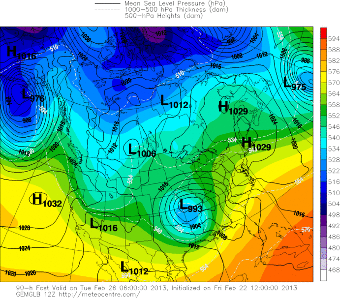
With that said, this system has a equal chance of busting. We shall see.
This Storm has the potential to play a major role in the development of a huge southward dip in the jet stream in the Eastern US. As we seen all year, a series of storms changes patterns. This is no exception. IMO
Such a southward dip could make for an extended period of unseasonably cold conditions in the storm's wake from the Northeast all the way down to us in Florida and along the Gulf Coast to Gomey. In fact, check this out.
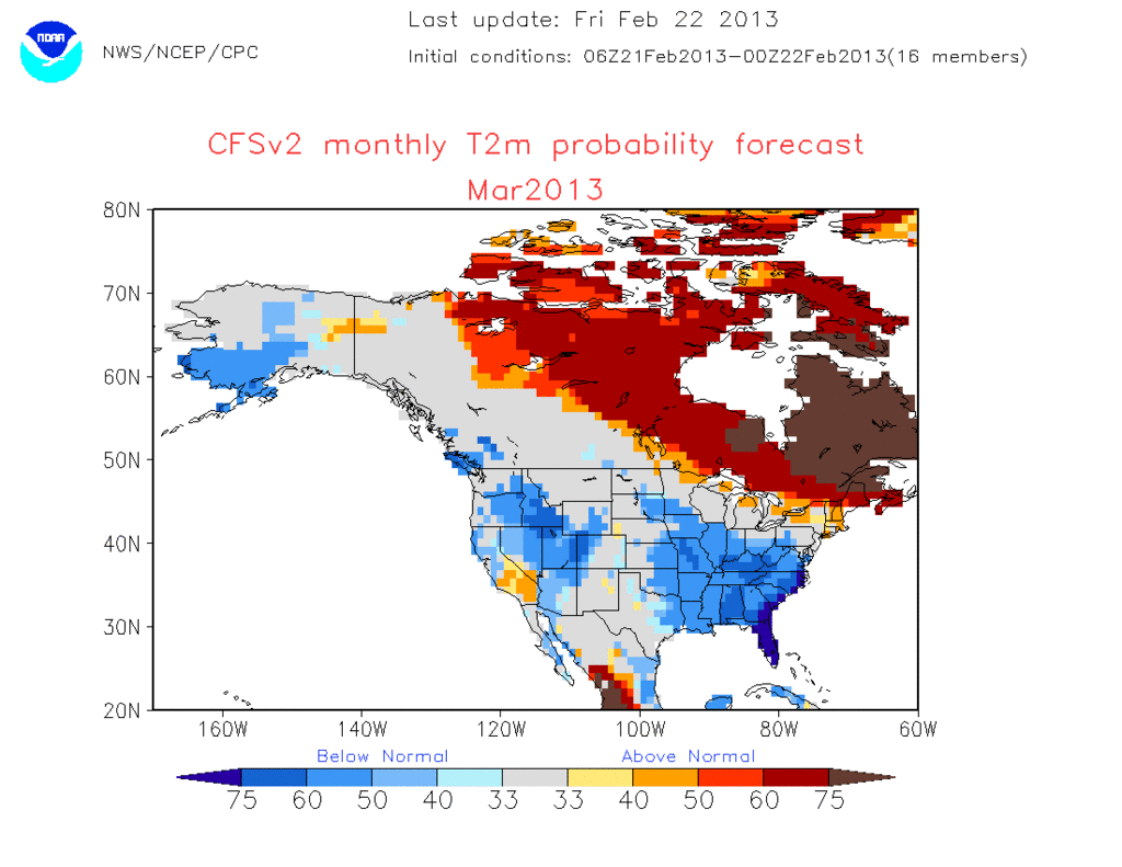

Mow, most of the time I think the CFS is out to lunch, But this time the models and teleconnections are also agreeing, which they didn't do before. So far this year the AO and NAO havent' timed or synched up yet. This time will most likely will. They both are synching up. This is not long range stuff, it is happening in a couple of days. It will begin mid week with the next big upper low closing off in the Lakes. This will be the deep trough in the heart land and Eastern US that opens up the door to Canada and ushers in sustained cold, unlike no pattern seen this Winter. Now it's late Winter, so this won't be Severe Cold, but plenty cold aloft. And the GFS just in keeps such a strong Greenland block and holds this trough in place with several systems rotating though the Deep Eastern Trough, with a hint at retrograding flow.
This is about how you want to see the GFS in this time range....IE, cold and dry. There is probably going to be a couple of strong systems that round the bend of the trough and could tap the Gulf, turning into a Major Winter Storm in the Southeast, MidAtlantic or Northeast (or all 3).The CFS has had a hard time this winter but methinks is was because all the mess in the Pacific early on in the season.
I got to play this again. I have seen it for the past couple of days on various forums. LMFAO
Lets look at the current data.
We have to look out West once again for the set up. Currently, a strong upper level disturbance is moving onshore from the pacific.
By tomorrow, the ULL will be somewhere in this area. This ULL will move to the SE.
On Monday, a subtropical jet will set up and a surface Low could develop anywhere from the Northern GOM to Georgia. Just a thought even though none of the major models really consistently show this, the signs kinda lean towards it. I probably will be wrong. But, if it happened, this will feed the warm moist flow into a are that the sub-tropical jet will be creating havoc as far as severe weather goes in the deep South.
You can see the two (2) pieces of energy on the NAM simulated radar.
You can see the flow that is setting up for the ULL to travel
So with this Split Flow, Trouble cometh
...DISCUSSION...
MONDAY /DAY 4/...MODEL CONSENSUS IS THAT VIGOROUS SHORTWAVE TROUGH
WILL EJECT FROM THE SRN/CNTRL PLAINS MONDAY MORNING TO THE TN/OH
VALLEYS 12Z TUESDAY. ATTENDANT SFC LOW WILL OCCLUDE OVER THE MID MS
AND OH VALLEYS...WHILE SECONDARY CYCLOGENESIS IS FORECAST FROM SRN
GA TO COASTAL CAROLINAS IN ASSOCIATION WITH UPPER JET ROUNDING BASE
OF THE TROUGH. THE FRONT TRAILING FROM THE OCCLUDED LOW WILL ADVANCE
THROUGH MOST OF THE SERN STATES...WHILE A WARM FRONT LIFTS NWD INTO
GULF COASTAL REGION.
CONCERN IS HOW FAR INLAND WARM SECTOR CAN ADVANCE GIVEN THE COOL SFC
STABLE LAYER ASSOCIATED WITH CP HIGH PRESSURE THAT WILL BE CENTERED
FROM THE OH VALLEY INTO THE CAROLINAS...AND LIKELIHOOD OF WIDESPREAD
RAIN NORTH OF WARM FRONT. POTENTIAL WILL EXIST FOR SMALL WARM SECTOR
TO DEVELOP INLAND...AS FAR NORTH AS SRN GA. THIS WILL BE COINCIDENT
WITH A STRENGTHENING LLJ SUPPORTING FAVORABLE HODOGRAPHS FOR LOW
LEVEL MESOCYCLONES AND A THREAT OF TORNADOES WITH ANY SFC BASED
ACTIVITY DEVELOPING NEAR THE WARM FRONT. ALSO...OTHER STORMS MAY
DEVELOP LINEAR MODES ALONG AND JUST AHEAD OF THE COLD FRONT WITH A
THREAT OF DAMAGING WIND.
BEYOND DAY 4...MODELS SUGGEST A LARGE UPPER TROUGH WILL EVOLVE OVER
THE ERN HALF OF THE COUNTRY WHICH WILL BE ACCOMPANIED BY GENERALLY
OFFSHORE FLOW OVER THE GULF AND LOW SEVERE POTENTIAL INLAND.
...DISCUSSION...
WITHIN PERSISTENT BROADER SCALE UPPER TROUGHING...IN THE SOUTHERN
BRANCH OF A SPLIT FLOW EMERGING FROM THE PACIFIC...MEDIUM RANGE
MODELS CONTINUE TO INDICATE THE NEXT IN A SERIES OF STRONG SHORT
WAVE TROUGHS WILL DIG ACROSS THE SOUTHERN ROCKIES INTO THE SOUTHERN
PLAINS LATE THIS COMING WEEKEND. AS IT DOES...IT APPEARS LIKELY TO
GRADUALLY COME IN PHASE WITH ANOTHER STRONG JET STREAK EMERGING FROM
THE SUBTROPICAL EASTERN PACIFIC...THEN TAKE ON A NEGATIVE TILT
ACROSS THE LOWER MISSISSIPPI VALLEY...BEFORE LIFTING TOWARD THE
GREAT LAKES REGION DURING THE EARLY TO MIDDLE OF NEXT WEEK. WHILE
PRIMARY SURFACE CYCLOGENESIS APPEARS PROBABLE ACROSS THE SOUTH
CENTRAL PLAINS INTO AND THROUGH THE MIDDLE MISSISSIPPI
VALLEY...MODELS SUGGEST THAT A SIGNIFICANT SECONDARY WAVE WILL FORM
ALONG A FRONTAL ZONE ADVANCING/REDEVELOPING NORTHWARD OUT OF THE
NORTHERN GULF OF MEXICO. WHILE VARIABILITY LINGERS AMONG THE MODELS
AND MODEL ENSEMBLES...IT SEEMS PROBABLE THAT PEAK SEVERE WEATHER
POTENTIAL WITH THIS SYSTEM WILL OCCUR ON MONDAY...AS A MOIST WARM
SECTOR OVERSPREADS MUCH OF THE CENTRAL AND EASTERN GULF STATES.
DEEP LAYER AND LOW-LEVEL SHEAR SHOULD BE MORE THAN SUFFICIENT FOR
ORGANIZED SQUALL LINE AND SUPERCELL DEVELOPMENT...WITH THE RISK FOR
DAMAGING WIND AND TORNADOES.
With that said, this system has a equal chance of busting. We shall see.
This Storm has the potential to play a major role in the development of a huge southward dip in the jet stream in the Eastern US. As we seen all year, a series of storms changes patterns. This is no exception. IMO
Such a southward dip could make for an extended period of unseasonably cold conditions in the storm's wake from the Northeast all the way down to us in Florida and along the Gulf Coast to Gomey. In fact, check this out.
Mow, most of the time I think the CFS is out to lunch, But this time the models and teleconnections are also agreeing, which they didn't do before. So far this year the AO and NAO havent' timed or synched up yet. This time will most likely will. They both are synching up. This is not long range stuff, it is happening in a couple of days. It will begin mid week with the next big upper low closing off in the Lakes. This will be the deep trough in the heart land and Eastern US that opens up the door to Canada and ushers in sustained cold, unlike no pattern seen this Winter. Now it's late Winter, so this won't be Severe Cold, but plenty cold aloft. And the GFS just in keeps such a strong Greenland block and holds this trough in place with several systems rotating though the Deep Eastern Trough, with a hint at retrograding flow.
This is about how you want to see the GFS in this time range....IE, cold and dry. There is probably going to be a couple of strong systems that round the bend of the trough and could tap the Gulf, turning into a Major Winter Storm in the Southeast, MidAtlantic or Northeast (or all 3).The CFS has had a hard time this winter but methinks is was because all the mess in the Pacific early on in the season.
I got to play this again. I have seen it for the past couple of days on various forums. LMFAO

emcf30- Posts : 975
Reputation : 10
Join date : 2012-07-16
Age : 93
Re: Next Trouble Maker
![]() by emcf30 Sun Feb 24, 2013 7:19 am
by emcf30 Sun Feb 24, 2013 7:19 am
The model target still seems to be the KC metro.

emcf30- Posts : 975
Reputation : 10
Join date : 2012-07-16
Age : 93

emcf30- Posts : 975
Reputation : 10
Join date : 2012-07-16
Age : 93

emcf30- Posts : 975
Reputation : 10
Join date : 2012-07-16
Age : 93
Re: Next Trouble Maker
![]() by emcf30 Sun Feb 24, 2013 7:35 am
by emcf30 Sun Feb 24, 2013 7:35 am
You can see on the surface maps the lows starting to consolidate
Yesterday

Today

Yesterday
Today
emcf30- Posts : 975
Reputation : 10
Join date : 2012-07-16
Age : 93
Re: Next Trouble Maker
![]() by StAugustineFL Sun Feb 24, 2013 7:51 am
by StAugustineFL Sun Feb 24, 2013 7:51 am

StAugustineFL- Posts : 2231
Reputation : 64
Join date : 2012-07-17

StAugustineFL- Posts : 2231
Reputation : 64
Join date : 2012-07-17

StAugustineFL- Posts : 2231
Reputation : 64
Join date : 2012-07-17

emcf30- Posts : 975
Reputation : 10
Join date : 2012-07-16
Age : 93
Re: Next Trouble Maker
![]() by emcf30 Sun Feb 24, 2013 9:50 am
by emcf30 Sun Feb 24, 2013 9:50 am
History 101: Snow in Florida
It is rare for snow to fall in Florida, but it does happen. The reason that snow so rarely occurs in this U.S. state is that freezing temperatures in Florida are generally caused by the cold and dry winds of anticyclones. Frost is more common than snow, requiring temperatures of 45°F or less at 7 ft above sea level, a cloudless sky, and a relative humidity of 65% or more. In the general case, for snow to occur, the polar jet stream must move southward through Texas and into the Gulf of Mexico, with a stalled cold front across the southern portion of the state curving northeastward to combine freezing air into the frontal clouds. Most of the state is in a rare portion of the continental United States that receives a mean maximum monthly snowfall amount of zero, the only other such areas being southern Texas and parts of California.
Much of the known information on snow in Florida prior to 1900 is from weather climatology provided by the Jacksonville National Weather Service; for this reason, information for other locations is sparse. The earliest recorded instance of snow in Florida was a snowstorm that occurred in 1774; being unaccustomed to snow, some residents called it "extraordinary white rain." The first White Christmas in Jacksonville's history resulted from a snowfall that occurred on December 23, 1989. The most recent occurrence of snow in Florida took place on January 9, 2011, when sleet was reported in the counties of Escambia and Santa Rosa.
Pre-1900 (17 reported events)
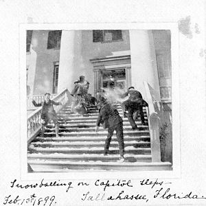
Snowball fight on the steps of the Florida Capitol, February 1899
1774: A snowstorm extends across much of the state. The affected residents speak of it as an "extraordinary white rain."
1797: Land surveyor Andrew Ellicott reports 8 in (203 mm) snowdrifts near the source of the St. Marys River in Baker County.
January 11, 1800: Over 5 in (127 mm) of snow is on the ground along the St. Marys River to the north of Jacksonville, the highest recorded snowfall total in Jacksonville history.
January 13, 1852: Several hours of snow accumulates to a total of 0.5 in (13 mm) in Jacksonville.
February 28, 1855: Light snow flurries are reported in Jacksonville.
January 29, 1868: Light sleet falls throughout the night in northeastern Florida.
February 28, 1869: During the morning hours, some snow flurries are reported in Jacksonville.
January 10, 1873: At 7:25 a.m., a few snowflakes fall near Jacksonville.
February 4 & 5, 1875: Light sleet occurs between midnight and sunrise on both dates.
January 4, 1879: For an hour and a half, sleet falls in Jacksonville before turning to rain. The rainfall covers grounds and trees with ice early on January 5, breaking the limbs of many orange trees.
January 5, 1887: About 1 in (25 mm) of snow falls at Pensacola.
January 14, 1892: 0.4 in (10 mm) of snow is reported at Pensacola.
February 14, 1892: Pensacola reports 3 in (76 mm) of snow.
December 27, 1892: Light snow falls in various intervals in the northeastern portion of the state.
January 18, 1893: Falling sleet turns to snow before later changing to rain in Jacksonville.
February 14, 1895: Two short durations of light snow are reported in Jacksonville.
February 12 & 13, 1899: Rain changes to sleet and later turns to snow during the Great Blizzard of 1899, with the snow falling for about eight hours. With temperatures of about 10°F, the snow accumulates to 2 in near Jacksonville and 4 in at Lake Butler. In some locations, the snow remains on the ground for several days.
Now, lets look at modern times
20th century (20 reported events)
December 16, 1901: Light snow is reported in Jacksonville.
February 7, 1907: Downtown Jacksonville receives light snow flurries in the early afternoon.
November 27, 1912: An overnight period of snow covers the ground and trees with a 0.5 in layer in northern Florida.
January 22, 1935: Snow falls until the next morning, with Pensacola recording 1 in.
December 23, 1989, Jacksonville snowfall

February 2, 1951: Snowfall begins and ends the following day, accumulating to about 2 in. in Saint Augustine and Crescent City. December 14, 1952: Sleet and snow falls across the northern portion of the state, though there is very little accumulation.
December 14, 1953: Light sleet occurs in the morning in Marianna.
March 6, 1954: About 4 in. of snow accumulates at Milton Experimental Station, Santa Rosa County within a 24 hour period; the highest such total for Florida according to official modern records.
March 28, 1955: Snowfall accumulates to about 1 in. in Marianna along the Florida Panhandle.
February 13, 1958: An overnight rainfall changes to snowfall in Jacksonville and accumulates to about 1.5 in. Additionally, Tallahassee reports a record 2.8 in.
February 9, 1973: Snow falls over the northern portion of the state, including a total of 2 in. in Pensacola, with unofficial reports of up to 8 in.
January 17, 1977: The pressure gradient between a strong ridge over the Mississippi Valley and a Nor'easter over Atlantic Canada sends very cold temperatures southward into the state. Areas around Pensacola are the first to receive the snow. Then the rest of The Panhandle. Followed by record accumulations for The Nature Coast, the I-4 corridor (both Orlando and Tampa receive light accumulations of about 1-2" with a few isolated spots reportedly receiving 3-6"), and finally South Florida.

I remember this day very well. Broke my leg playing hard in the snow and slipped on a ice patch on the track at school.

By early on January 19, West Palm Beach reported snow for the first time on record, with snow flurries reaching as far south as Homestead. The snow causes little impact as it was of the dry variety, though the accompanying cold air results in hundreds of millions of dollars in damage (Orlando tied the 1899 record of over six consecutive nights well-below freezing). On January 20, The Miami Herald reports the event as the front page story, with a headline of a size usually reserved for the declaration of war.
Late January, 1977: Pensacola receives snowfall.
March 2, 1980: About 0.25 in. of snow covers car tops and patio furniture in Jacksonville.
March 1, 1986: 0.5 in. of snow accumulates overnight in Jacksonville before melting within 30 minutes due to the morning sun.
December 23, 1989: Light rain in Jacksonville turns to freezing rain as temperatures drop, and later changes to snow. The snow totals several inches in some locations, and results in the first White Christmas in the city's history.
December 24, 1989: Light flurries fall in the Tampa metro area early in the day and even during an early afternoon NFL game. 1 death is reported in Tampa, 2 in Miami and 1 in Jacksonville because of the extreme cold.
March 12, 1993: The 1993 Superstorm produces up to 4 in. of snow along the Florida Panhandle.
January 8, 1996: Snow flurries are reported from Crystal River to New Port Richey with no accumulation.
December 18, 1996: A plume of cold air causes snow to form in the northwestern portion of Escambia County.
21st century (12 reported events)
Satellite image for the January 24, 2003, snowfall

January 24, 2003: A plume of Arctic air produces widespread record low temperatures and light snow flurries along the eastern coastline. The snow is described as ocean effect snow, identical to lake effect snow in that it occurs due to very cold air passing over relatively warm water temperatures. The snow reaches as far south as Fort Pierce.
December 25, 2004: Locations along the Florida Panhandle receive a dusting of snow.
November 21, 2006: An eastward moving weather system produces a very light dusting and snowflakes in central Florida. It is the first snow in November in the state since 1912. February 3, 2007: Very light snow flurries are reported in the northeastern panhandle, lasting less than an hour.
January 3, 2008: Light snow flurries are reported near Daytona Beach.
January 8–9, 2010: Very light dusting of snow seen in the eastern Jacksonville area. Light snow also fell in parts of central Florida, which briefly accumulated in Ocala and other parts of Marion County. Sleet was widespread and snow was isolated across the Orlando area, Tampa and also in Melbourne. Isolated flurries were even reported as from West Palm Beach to as far south as Kendall and sleet in a few spots in the South Florida metropolitan area for only the second time in record history and first time since 1977.
February 12, 2010: Portions of northwestern Florida experience snowfall totals of around 1 in.
February 14, 2010: 0.5 in. of snow fell across the northern halves of Escambia, Santa Rosa, Walton and Okaloosa Counties.
December 8, 2010: Snow mixed with rain is reported in western parts of the panhandle, north of Pensacola.
December 26, 2010: A mix of snow and sleet was reported in Jacksonville by NWS.
December 28, 2010: Light snow was reported at Tampa Executive at 1AM and 5AM local time, following a rare freezing fog event around midnight.
January 9, 2011: Sleet is reported in the Pensacola area, as well as other places in Escambia and Santa Rosa counties. There was no accumulation.
So the set up for next Sunday does hold a chance for snow. But, as we know, looking at things and hanging your hat on it a week plus is not wise. We look for trends not exact specifics of an event. The trend, is for a chance of snow according to the models. Reality is, those same models show Surface temperatures in the Florida are in the 40s run after run, despite sub-freezing temperatures aloft. I don't think there's really much chance of snow with this temperature set up, to be honest. However, it is all about timing. As I said yesterday, I believe with the projected set-up, looking at the signals the atmosphere is showing, and the pattern it is very possible if the temps cooperate. Models consistency has been good for the past couple of days showing snow in Central Florida. Question is, can the surface temp drop low enough. I think the atmosphere will hold up to it's part but the surface I have questions about.
It is rare for snow to fall in Florida, but it does happen. The reason that snow so rarely occurs in this U.S. state is that freezing temperatures in Florida are generally caused by the cold and dry winds of anticyclones. Frost is more common than snow, requiring temperatures of 45°F or less at 7 ft above sea level, a cloudless sky, and a relative humidity of 65% or more. In the general case, for snow to occur, the polar jet stream must move southward through Texas and into the Gulf of Mexico, with a stalled cold front across the southern portion of the state curving northeastward to combine freezing air into the frontal clouds. Most of the state is in a rare portion of the continental United States that receives a mean maximum monthly snowfall amount of zero, the only other such areas being southern Texas and parts of California.
Much of the known information on snow in Florida prior to 1900 is from weather climatology provided by the Jacksonville National Weather Service; for this reason, information for other locations is sparse. The earliest recorded instance of snow in Florida was a snowstorm that occurred in 1774; being unaccustomed to snow, some residents called it "extraordinary white rain." The first White Christmas in Jacksonville's history resulted from a snowfall that occurred on December 23, 1989. The most recent occurrence of snow in Florida took place on January 9, 2011, when sleet was reported in the counties of Escambia and Santa Rosa.
Pre-1900 (17 reported events)
Snowball fight on the steps of the Florida Capitol, February 1899
1774: A snowstorm extends across much of the state. The affected residents speak of it as an "extraordinary white rain."
1797: Land surveyor Andrew Ellicott reports 8 in (203 mm) snowdrifts near the source of the St. Marys River in Baker County.
January 11, 1800: Over 5 in (127 mm) of snow is on the ground along the St. Marys River to the north of Jacksonville, the highest recorded snowfall total in Jacksonville history.
January 13, 1852: Several hours of snow accumulates to a total of 0.5 in (13 mm) in Jacksonville.
February 28, 1855: Light snow flurries are reported in Jacksonville.
January 29, 1868: Light sleet falls throughout the night in northeastern Florida.
February 28, 1869: During the morning hours, some snow flurries are reported in Jacksonville.
January 10, 1873: At 7:25 a.m., a few snowflakes fall near Jacksonville.
February 4 & 5, 1875: Light sleet occurs between midnight and sunrise on both dates.
January 4, 1879: For an hour and a half, sleet falls in Jacksonville before turning to rain. The rainfall covers grounds and trees with ice early on January 5, breaking the limbs of many orange trees.
January 5, 1887: About 1 in (25 mm) of snow falls at Pensacola.
January 14, 1892: 0.4 in (10 mm) of snow is reported at Pensacola.
February 14, 1892: Pensacola reports 3 in (76 mm) of snow.
December 27, 1892: Light snow falls in various intervals in the northeastern portion of the state.
January 18, 1893: Falling sleet turns to snow before later changing to rain in Jacksonville.
February 14, 1895: Two short durations of light snow are reported in Jacksonville.
February 12 & 13, 1899: Rain changes to sleet and later turns to snow during the Great Blizzard of 1899, with the snow falling for about eight hours. With temperatures of about 10°F, the snow accumulates to 2 in near Jacksonville and 4 in at Lake Butler. In some locations, the snow remains on the ground for several days.
Now, lets look at modern times
20th century (20 reported events)
December 16, 1901: Light snow is reported in Jacksonville.
February 7, 1907: Downtown Jacksonville receives light snow flurries in the early afternoon.
November 27, 1912: An overnight period of snow covers the ground and trees with a 0.5 in layer in northern Florida.
January 22, 1935: Snow falls until the next morning, with Pensacola recording 1 in.
December 23, 1989, Jacksonville snowfall
February 2, 1951: Snowfall begins and ends the following day, accumulating to about 2 in. in Saint Augustine and Crescent City. December 14, 1952: Sleet and snow falls across the northern portion of the state, though there is very little accumulation.
December 14, 1953: Light sleet occurs in the morning in Marianna.
March 6, 1954: About 4 in. of snow accumulates at Milton Experimental Station, Santa Rosa County within a 24 hour period; the highest such total for Florida according to official modern records.
March 28, 1955: Snowfall accumulates to about 1 in. in Marianna along the Florida Panhandle.
February 13, 1958: An overnight rainfall changes to snowfall in Jacksonville and accumulates to about 1.5 in. Additionally, Tallahassee reports a record 2.8 in.
February 9, 1973: Snow falls over the northern portion of the state, including a total of 2 in. in Pensacola, with unofficial reports of up to 8 in.
January 17, 1977: The pressure gradient between a strong ridge over the Mississippi Valley and a Nor'easter over Atlantic Canada sends very cold temperatures southward into the state. Areas around Pensacola are the first to receive the snow. Then the rest of The Panhandle. Followed by record accumulations for The Nature Coast, the I-4 corridor (both Orlando and Tampa receive light accumulations of about 1-2" with a few isolated spots reportedly receiving 3-6"), and finally South Florida.
I remember this day very well. Broke my leg playing hard in the snow and slipped on a ice patch on the track at school.
By early on January 19, West Palm Beach reported snow for the first time on record, with snow flurries reaching as far south as Homestead. The snow causes little impact as it was of the dry variety, though the accompanying cold air results in hundreds of millions of dollars in damage (Orlando tied the 1899 record of over six consecutive nights well-below freezing). On January 20, The Miami Herald reports the event as the front page story, with a headline of a size usually reserved for the declaration of war.
Late January, 1977: Pensacola receives snowfall.
March 2, 1980: About 0.25 in. of snow covers car tops and patio furniture in Jacksonville.
March 1, 1986: 0.5 in. of snow accumulates overnight in Jacksonville before melting within 30 minutes due to the morning sun.
December 23, 1989: Light rain in Jacksonville turns to freezing rain as temperatures drop, and later changes to snow. The snow totals several inches in some locations, and results in the first White Christmas in the city's history.
December 24, 1989: Light flurries fall in the Tampa metro area early in the day and even during an early afternoon NFL game. 1 death is reported in Tampa, 2 in Miami and 1 in Jacksonville because of the extreme cold.
March 12, 1993: The 1993 Superstorm produces up to 4 in. of snow along the Florida Panhandle.
January 8, 1996: Snow flurries are reported from Crystal River to New Port Richey with no accumulation.
December 18, 1996: A plume of cold air causes snow to form in the northwestern portion of Escambia County.
21st century (12 reported events)
Satellite image for the January 24, 2003, snowfall
January 24, 2003: A plume of Arctic air produces widespread record low temperatures and light snow flurries along the eastern coastline. The snow is described as ocean effect snow, identical to lake effect snow in that it occurs due to very cold air passing over relatively warm water temperatures. The snow reaches as far south as Fort Pierce.
December 25, 2004: Locations along the Florida Panhandle receive a dusting of snow.
November 21, 2006: An eastward moving weather system produces a very light dusting and snowflakes in central Florida. It is the first snow in November in the state since 1912. February 3, 2007: Very light snow flurries are reported in the northeastern panhandle, lasting less than an hour.
January 3, 2008: Light snow flurries are reported near Daytona Beach.
January 8–9, 2010: Very light dusting of snow seen in the eastern Jacksonville area. Light snow also fell in parts of central Florida, which briefly accumulated in Ocala and other parts of Marion County. Sleet was widespread and snow was isolated across the Orlando area, Tampa and also in Melbourne. Isolated flurries were even reported as from West Palm Beach to as far south as Kendall and sleet in a few spots in the South Florida metropolitan area for only the second time in record history and first time since 1977.
February 12, 2010: Portions of northwestern Florida experience snowfall totals of around 1 in.
February 14, 2010: 0.5 in. of snow fell across the northern halves of Escambia, Santa Rosa, Walton and Okaloosa Counties.
December 8, 2010: Snow mixed with rain is reported in western parts of the panhandle, north of Pensacola.
December 26, 2010: A mix of snow and sleet was reported in Jacksonville by NWS.
December 28, 2010: Light snow was reported at Tampa Executive at 1AM and 5AM local time, following a rare freezing fog event around midnight.
January 9, 2011: Sleet is reported in the Pensacola area, as well as other places in Escambia and Santa Rosa counties. There was no accumulation.
So the set up for next Sunday does hold a chance for snow. But, as we know, looking at things and hanging your hat on it a week plus is not wise. We look for trends not exact specifics of an event. The trend, is for a chance of snow according to the models. Reality is, those same models show Surface temperatures in the Florida are in the 40s run after run, despite sub-freezing temperatures aloft. I don't think there's really much chance of snow with this temperature set up, to be honest. However, it is all about timing. As I said yesterday, I believe with the projected set-up, looking at the signals the atmosphere is showing, and the pattern it is very possible if the temps cooperate. Models consistency has been good for the past couple of days showing snow in Central Florida. Question is, can the surface temp drop low enough. I think the atmosphere will hold up to it's part but the surface I have questions about.
emcf30- Posts : 975
Reputation : 10
Join date : 2012-07-16
Age : 93
Re: Next Trouble Maker
![]() by emcf30 Sun Feb 24, 2013 12:25 pm
by emcf30 Sun Feb 24, 2013 12:25 pm
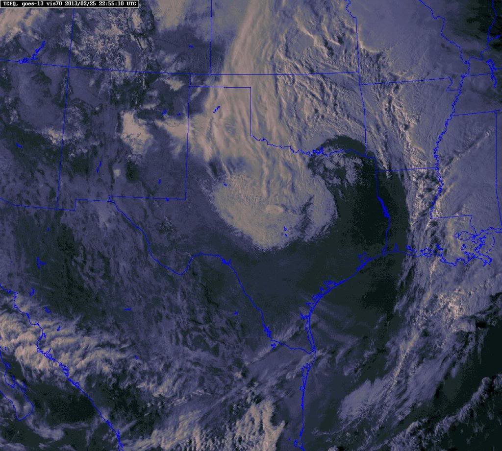
Cool Image. Ahead of the next system, visible satellite shows existing snow cover over KS/OK/MO as it outlines rivers/lakes..

emcf30- Posts : 975
Reputation : 10
Join date : 2012-07-16
Age : 93

emcf30- Posts : 975
Reputation : 10
Join date : 2012-07-16
Age : 93
Re: Next Trouble Maker
![]() by emcf30 Sun Feb 24, 2013 10:11 pm
by emcf30 Sun Feb 24, 2013 10:11 pm
Another weird one. The one earlier was in Texas with temps near 70 at the same time they were under a Blizzard Warning.

Now in Oklahoma, They has a Severe Thunderstorm Warning while under a Blizzard Warning.

Now in Oklahoma, They has a Severe Thunderstorm Warning while under a Blizzard Warning.
emcf30- Posts : 975
Reputation : 10
Join date : 2012-07-16
Age : 93
Re: Next Trouble Maker
![]() by emcf30 Sun Feb 24, 2013 10:21 pm
by emcf30 Sun Feb 24, 2013 10:21 pm
Now that we are actually within the usable time-frame of the NAM/NAM hi-res (and it seemed to initialize better than previous runs), this simulated reflectivity depicts the epic thrashing and evisceration of NW OK once the deform band gets going.

emcf30- Posts : 975
Reputation : 10
Join date : 2012-07-16
Age : 93

emcf30- Posts : 975
Reputation : 10
Join date : 2012-07-16
Age : 93

emcf30- Posts : 975
Reputation : 10
Join date : 2012-07-16
Age : 93
Re: Next Trouble Maker
![]() by emcf30 Mon Feb 25, 2013 5:23 am
by emcf30 Mon Feb 25, 2013 5:23 am
Crazy, still very persistent. Still showing snow on Sunday even though the surface temps are to warm.

emcf30- Posts : 975
Reputation : 10
Join date : 2012-07-16
Age : 93
Re: Next Trouble Maker
![]() by StAugustineFL Mon Feb 25, 2013 12:40 pm
by StAugustineFL Mon Feb 25, 2013 12:40 pm

URGENT - IMMEDIATE BROADCAST REQUESTED
TORNADO WATCH NUMBER 41
NWS STORM PREDICTION CENTER NORMAN OK
1225 PM EST MON FEB 25 2013
THE NWS STORM PREDICTION CENTER HAS ISSUED A
TORNADO WATCH FOR PORTIONS OF
NORTH FLORIDA AND THE EASTERN FLORIDA PANHANDLE
COASTAL WATERS
EFFECTIVE THIS MONDAY AFTERNOON AND EVENING FROM 1225 PM UNTIL
800 PM EST.
TORNADOES...HAIL TO 1.5 INCHES IN DIAMETER...THUNDERSTORM WIND
GUSTS TO 70 MPH...AND DANGEROUS LIGHTNING ARE POSSIBLE IN THESE
AREAS.
THE TORNADO WATCH AREA IS APPROXIMATELY ALONG AND 120 STATUTE
MILES EAST AND WEST OF A LINE FROM 5 MILES NORTH NORTHEAST OF
JACKSONVILLE FLORIDA TO 35 MILES SOUTHWEST OF CROSS CITY FLORIDA.
FOR A COMPLETE DEPICTION OF THE WATCH SEE THE ASSOCIATED WATCH
OUTLINE UPDATE (WOUS64 KWNS WOU1).
REMEMBER...A TORNADO WATCH MEANS CONDITIONS ARE FAVORABLE FOR
TORNADOES AND SEVERE THUNDERSTORMS IN AND CLOSE TO THE WATCH
AREA. PERSONS IN THESE AREAS SHOULD BE ON THE LOOKOUT FOR
THREATENING WEATHER CONDITIONS AND LISTEN FOR LATER STATEMENTS
AND POSSIBLE WARNINGS.
DISCUSSION...SQLN NOW W OF TALLAHASSEE AND APALACHICOLA MAY INCREASE
AS THE FEATURE...POSSIBLY TIED TO A WEAK IMPULSE IN WSW FLOW
ALOFT...INTERACTS WITH SLOWLY-ADVANCING W-E WARM FRONT DOWNSTREAM
ACROSS N FL. POTENTIAL WILL EXIST FOR BOWING SEGMENTS AND/OR A
TORNADO OR TWO WHERE STRONGER ASSOCIATED UPDRAFTS INTERACT WITH WARM
FRONT. ELEVATED STORMS WITH SVR HAIL MAY OCCUR IN NRN PART OF
LINE...AND AN ADDITIONAL STORM OR TWO MAY FORM AHEAD OF IT AS
MODERATE SFC HEATING BOOSTS SBCAPE TO AROUND 1000 J/KG.
AVIATION...TORNADOES AND A FEW SEVERE THUNDERSTORMS WITH HAIL
SURFACE AND ALOFT TO 1.5 INCHES. EXTREME TURBULENCE AND SURFACE
WIND GUSTS TO 60 KNOTS. A FEW CUMULONIMBI WITH MAXIMUM TOPS TO
450. MEAN STORM MOTION VECTOR 27030.
...CORFIDI
StAugustineFL- Posts : 2231
Reputation : 64
Join date : 2012-07-17
Re: Next Trouble Maker
![]() by sangria Mon Feb 25, 2013 4:32 pm
by sangria Mon Feb 25, 2013 4:32 pm
This is for "educational" purposes only.......Aug is forecast, to be in the "hole" over the next 48 hours......(based on this futurecast)........ We'll compare his actual, to this, come Wed at 4pm...


sangria- Admin
- Posts : 2345
Reputation : 55
Join date : 2012-07-16

emcf30- Posts : 975
Reputation : 10
Join date : 2012-07-16
Age : 93
Re: Next Trouble Maker
![]() by StAugustineFL Tue Feb 26, 2013 9:58 am
by StAugustineFL Tue Feb 26, 2013 9:58 am
Brother's front yard. 10" so far and still falling.

StAugustineFL- Posts : 2231
Reputation : 64
Join date : 2012-07-17
Re: Next Trouble Maker
![]() by StAugustineFL Tue Feb 26, 2013 11:51 am
by StAugustineFL Tue Feb 26, 2013 11:51 am
sangria wrote:This is for "educational" purposes only.......Aug is forecast, to be in the "hole" over the next 48 hours......(based on this futurecast)........ We'll compare his actual, to this, come Wed at 4pm...
2 day total of 1.16"
 futurecast.
StAugustineFL- Posts : 2231
Reputation : 64
Join date : 2012-07-17
sangria- Admin
- Posts : 2345
Reputation : 55
Join date : 2012-07-16

sangria- Admin
- Posts : 2345
Reputation : 55
Join date : 2012-07-16

sangria- Admin
- Posts : 2345
Reputation : 55
Join date : 2012-07-16
Re: Next Trouble Maker
![]() by emcf30 Tue Feb 26, 2013 1:52 pm
by emcf30 Tue Feb 26, 2013 1:52 pm
Cars stranded on Hillside Road in Amarillo. Courtesy @pwarminski.

emcf30- Posts : 975
Reputation : 10
Join date : 2012-07-16
Age : 93
Page 1 of 2 • 1, 2 ![]()
Page 1 of 2
Permissions in this forum:
You cannot reply to topics in this forum


» summer 2019 hurricane season
» April-May Florida weather and local events etc
» NASCAR 2019
» Late January through February outlook
» FLORIDA/ALABAMA AND THE HOLIDAY SEASON WEATHER
» NASCAR 2018
» CLOSED Florida/Alabama Blog - October Tropical Mischief