


CLOSED 5/29/17 Florida/Alabama Weather Blog
:: Florida Blog
Page 7 of 16 •  1 ... 6, 7, 8 ... 11 ... 16
 ![]()
Re: CLOSED 5/29/17 Florida/Alabama Weather Blog
![]() by LargoFL Tue Jun 06, 2017 10:16 am
by LargoFL Tue Jun 06, 2017 10:16 am


LargoFL- Posts : 10724
Reputation : 130
Join date : 2017-03-05
Re: CLOSED 5/29/17 Florida/Alabama Weather Blog
![]() by LargoFL Tue Jun 06, 2017 10:38 am
by LargoFL Tue Jun 06, 2017 10:38 am
.UPDATE...
Deep mid/upper level trough and its associated energy will
continue to move across the northern gulf coast over the next
couple of days with a number of accompanied shortwave impulses
moving through the flow around this system. This pattern will keep
our weather unsettled with abundant clouds and scattered to
numerous showers and a few thunderstorms developing at almost
anytime. Potential for a couple of strong storms continues through
Wednesday, especially if we get some heating, with the main threat
being strong gusty winds. Locally heavy rainfall also a
possibility if convection begins to train like it did overnight
across Southwest Florida. The increasing south to southwest flow
will also cause tides to run about 1 to 2 feet above normal along
the Nature Coast around the time of the highest tides which is
around midday today and Wednesday. Overall the current grids/zone
forecast look ok and only some minor tweaks will be made.
&&
LargoFL- Posts : 10724
Reputation : 130
Join date : 2017-03-05
Re: CLOSED 5/29/17 Florida/Alabama Weather Blog
![]() by LargoFL Tue Jun 06, 2017 10:43 am
by LargoFL Tue Jun 06, 2017 10:43 am
LargoFL- Posts : 10724
Reputation : 130
Join date : 2017-03-05
Re: CLOSED 5/29/17 Florida/Alabama Weather Blog
![]() by LargoFL Tue Jun 06, 2017 10:47 am
by LargoFL Tue Jun 06, 2017 10:47 am
National Weather Service Jacksonville FL
1038 AM EDT Tue Jun 6 2017
...WAVES OF LOCALLY HEAVY RAINFALL AND EMBEDDED STRONG
THUNDERSTORMS CONTINUE THROUGH WEDNESDAY NIGHT...
.UPDATE...
A broad rain shield has persisted across the I-10/I-75 corridor
this morning and is now beginning to move into portions of
northeast Florida and southeast Georgia. This shield of rain has
generally produced rainfall amounts from 0.50-1.50 inches with
heavier amounts (2-3+ inches) across parts of Columbia and
Gilchrist counties where heavier downpours have persisted for
several hours. This activity is expected to continue northeastward
throughout the remainder of the morning and into early afternoon.
After the initial round of precipitation, additional thunderstorm
activity is expected to move in from the Gulf of Mexico
throughout the late morning and into early afternoon. It is during
this time where isolated strong storms are possible, specifically
across the Suwannee valley where weak effective wind shear (20-30
kts) is expected. Extensive cloud cover will likely limit the
overall coverage of instability and therefore strong/severe
storms, however, gusty winds will still be possible with the
strongest storms. Despite the marginal severe threat, deep
atmospheric moisture will result in very heavy rainfall,
especially where showers/storms persist for several hours.
Eventually, a break is expected across much of north Florida
during the late afternoon hours as the strongest forcing shifts
away from the area. Some uncertainty exists with a potential break
over southern Georgia during the afternoon as showers and
thunderstorms have persisted over the Fl panhandle and continue to
move eastward. Latest HRRR trends have shown showers and storms
continuing into the early evening hours so higher POPS will
continue through the afternoon hours.
&&
LargoFL- Posts : 10724
Reputation : 130
Join date : 2017-03-05
LargoFL- Posts : 10724
Reputation : 130
Join date : 2017-03-05
Re: CLOSED 5/29/17 Florida/Alabama Weather Blog
![]() by LargoFL Tue Jun 06, 2017 12:05 pm
by LargoFL Tue Jun 06, 2017 12:05 pm
FLC021-061915-
/O.NEW.KMFL.FF.W.0001.170606T1509Z-170606T1915Z/
/00000.0.ER.000000T0000Z.000000T0000Z.000000T0000Z.OO/
BULLETIN - EAS ACTIVATION REQUESTED
Flash Flood Warning
National Weather Service Miami FL
1109 AM EDT TUE JUN 6 2017
The National Weather Service in Miami has issued a
* Flash Flood Warning for...
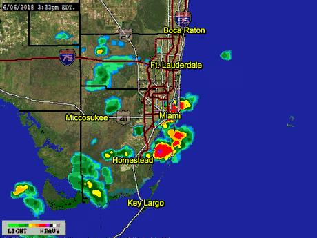
South central Collier County in southwestern Florida...
* Until 315 PM EDT
* At 1108 AM EDT,local law enforcement reported water beginning to
enter structures in Everglades City with numerous roads closed. Up
to 10 inches of rain has fallen with additional rainfall moving
into the area. Flash flooding is already occurring.
* Some locations that will experience flooding include...
Everglades City, Chokoloskee, Plantation Island and Carnestown.
PRECAUTIONARY/PREPAREDNESS ACTIONS...
Turn around, don`t drown when encountering flooded roads. Most flood
deaths occur in vehicles.
A Flash Flood Warning means that flooding is imminent or occurring.
If you are in the warned area move to higher ground immediately.
Residents living along streams and creeks should take immediate
precautions to protect life and property.
&&
LargoFL- Posts : 10724
Reputation : 130
Join date : 2017-03-05
Re: CLOSED 5/29/17 Florida/Alabama Weather Blog
![]() by LargoFL Tue Jun 06, 2017 12:06 pm
by LargoFL Tue Jun 06, 2017 12:06 pm
National Weather Service Miami FL
1143 AM EDT TUE JUN 6 2017
FLC011-061845-
/O.NEW.KMFL.FA.Y.0016.170606T1543Z-170606T1845Z/
/00000.N.ER.000000T0000Z.000000T0000Z.000000T0000Z.OO/
Broward FL-
1143 AM EDT TUE JUN 6 2017
The National Weather Service in Miami has issued a
* Flood Advisory for...
Central Broward County in southeastern Florida...
* Until 245 PM EDT
* At 1140 AM EDT, trained weather spotters reported street flooding
in Southwest Ranches due to thunderstorms. Additional street
flooding is expected. Up to three inches of rain have already
fallen.
* Some locations that will experience flooding include...
Pembroke Pines, Miramar, Coral Springs, Davie and Plantation.
Additional rainfall of one to three inches is expected over the
area. This additional rain will result in further flooding.
PRECAUTIONARY/PREPAREDNESS ACTIONS...
Turn around, don`t drown when encountering flooded roads. Most flood
deaths occur in vehicles.
Excessive runoff from heavy rainfall will cause flooding of small
creeks and streams, urban areas, highways, streets and underpasses as
well as other drainage areas and low lying spots.
LargoFL- Posts : 10724
Reputation : 130
Join date : 2017-03-05

LargoFL- Posts : 10724
Reputation : 130
Join date : 2017-03-05
Re: CLOSED 5/29/17 Florida/Alabama Weather Blog
![]() by LargoFL Tue Jun 06, 2017 12:25 pm
by LargoFL Tue Jun 06, 2017 12:25 pm
LargoFL- Posts : 10724
Reputation : 130
Join date : 2017-03-05
Re: CLOSED 5/29/17 Florida/Alabama Weather Blog
![]() by LargoFL Tue Jun 06, 2017 12:28 pm
by LargoFL Tue Jun 06, 2017 12:28 pm
LargoFL- Posts : 10724
Reputation : 130
Join date : 2017-03-05
Re: CLOSED 5/29/17 Florida/Alabama Weather Blog
![]() by BillsfaninSoFla Tue Jun 06, 2017 12:28 pm
by BillsfaninSoFla Tue Jun 06, 2017 12:28 pm
Hard rain, lots of lightning. And of course, I need to go to Publix after work. yikes lol
BillsfaninSoFla- Posts : 1966
Reputation : 52
Join date : 2017-03-05
Re: CLOSED 5/29/17 Florida/Alabama Weather Blog
![]() by LargoFL Tue Jun 06, 2017 12:28 pm
by LargoFL Tue Jun 06, 2017 12:28 pm
LargoFL- Posts : 10724
Reputation : 130
Join date : 2017-03-05
Re: CLOSED 5/29/17 Florida/Alabama Weather Blog
![]() by LargoFL Tue Jun 06, 2017 12:32 pm
by LargoFL Tue Jun 06, 2017 12:32 pm

LargoFL- Posts : 10724
Reputation : 130
Join date : 2017-03-05
Re: CLOSED 5/29/17 Florida/Alabama Weather Blog
![]() by LargoFL Tue Jun 06, 2017 12:34 pm
by LargoFL Tue Jun 06, 2017 12:34 pm
National Weather Service Tampa Bay Area Ruskin FL
1224 PM EDT TUE JUN 6 2017
FLZ248-249-061715-
Inland Hernando-Inland Pasco-
1224 PM EDT TUE JUN 6 2017
...A STRONG THUNDERSTORM WILL AFFECT NORTHEASTERN PASCO AND EASTERN
HERNANDO COUNTIES...
At 1224 PM EDT, a strong thunderstorm was located near Hernando
County Airport, or near Spring Hill, moving northeast at 25 mph.
Winds in excess of 40 mph are possible with this storm.
Locations impacted include...
Spring Hill, Brooksville, Hill n Dale, South Brooksville, Hernando
County Airport, North Brooksville, Ridge Manor, Darby, Shady Hills,
Blanton, Garden Grove, Lacoochee, Croom and Masaryktown.
Torrential rainfall is also occurring with this storm, and may cause
localized flooding. Do not drive your vehicle through flooded
roadways.
LAT...LON 2833 8244 2842 8256 2866 8230 2846 8210
TIME...MOT...LOC 1624Z 240DEG 20KT 2842 8246
$$
TBW
LargoFL- Posts : 10724
Reputation : 130
Join date : 2017-03-05
Re: CLOSED 5/29/17 Florida/Alabama Weather Blog
![]() by LargoFL Tue Jun 06, 2017 1:02 pm
by LargoFL Tue Jun 06, 2017 1:02 pm
...Florida and nearby Southeast States...
A somewhat complex mesoscale scenario exists across the region
today, mostly attributable to multiple corridors of existing
convection, related outflow, and corridors of differential cloud
cover. A mid/upper-level low will continue slowly eastward today
along the central Gulf Coast, with expectations for gradually
strengthening low/mid-level winds to gradually overspread especially
the central and southern FL Peninsula coincident with a very moist
air mass. Pockets of stronger afternoon heating, such as is
occurring at midday across the south-central Peninsula, could lead
to a diurnal intensification of storms. However, it appears that a
nearly full-period severe risk will exist for at least some damaging
wind/brief tornado risk, especially across parts of the central and
southern FL Peninsula where vertical shear will be strongest.
..Guyer/Marsh.. 06/06/2017
LargoFL- Posts : 10724
Reputation : 130
Join date : 2017-03-05
Re: CLOSED 5/29/17 Florida/Alabama Weather Blog
![]() by LargoFL Tue Jun 06, 2017 1:04 pm
by LargoFL Tue Jun 06, 2017 1:04 pm
Southwestern Collier County in southwestern Florida...
* Until 315 PM EDT Tuesday
* At 911 AM EDT, Doppler radar indicated thunderstorms producing
heavy rain which will cause flooding. 8 to 10 inches of rain has
already fallen. Multiple reports of flooded roadways with cars
stalled. Additional rainfall is expected over the area. Along with
high tide late this morning into the early afternoon this will
result in additional flooding.
* Some locations that will experience flooding include...
Naples, Marco Island, Everglades City, Chokoloskee and Golden Gate
Estates.
LargoFL- Posts : 10724
Reputation : 130
Join date : 2017-03-05
Re: CLOSED 5/29/17 Florida/Alabama Weather Blog
![]() by LargoFL Tue Jun 06, 2017 1:09 pm
by LargoFL Tue Jun 06, 2017 1:09 pm

LargoFL- Posts : 10724
Reputation : 130
Join date : 2017-03-05
Re: CLOSED 5/29/17 Florida/Alabama Weather Blog
![]() by LargoFL Tue Jun 06, 2017 1:45 pm
by LargoFL Tue Jun 06, 2017 1:45 pm
LargoFL- Posts : 10724
Reputation : 130
Join date : 2017-03-05
Re: CLOSED 5/29/17 Florida/Alabama Weather Blog
![]() by LargoFL Tue Jun 06, 2017 1:50 pm
by LargoFL Tue Jun 06, 2017 1:50 pm

LargoFL- Posts : 10724
Reputation : 130
Join date : 2017-03-05
Re: CLOSED 5/29/17 Florida/Alabama Weather Blog
![]() by LargoFL Tue Jun 06, 2017 1:53 pm
by LargoFL Tue Jun 06, 2017 1:53 pm
LargoFL- Posts : 10724
Reputation : 130
Join date : 2017-03-05

LargoFL- Posts : 10724
Reputation : 130
Join date : 2017-03-05
Re: CLOSED 5/29/17 Florida/Alabama Weather Blog
![]() by LargoFL Tue Jun 06, 2017 1:56 pm
by LargoFL Tue Jun 06, 2017 1:56 pm
LargoFL- Posts : 10724
Reputation : 130
Join date : 2017-03-05
Re: CLOSED 5/29/17 Florida/Alabama Weather Blog
![]() by sangria Tue Jun 06, 2017 2:19 pm
by sangria Tue Jun 06, 2017 2:19 pm
Not a ton of rain up in my area, but a nice light rain that has been on and off. So far:
6/5 at 7am - dumped .18"
6/6 at 7am - dumped .57"
6/6 currently in gauge - .5"
SW and South FL have been the benefactors of this little event, and I would say it will continue to be that way based on radar.
Billsfan, maybe by the end of the week things will be better for you!

sangria- Admin
- Posts : 2345
Reputation : 55
Join date : 2012-07-16
Re: CLOSED 5/29/17 Florida/Alabama Weather Blog
![]() by waterdipper Tue Jun 06, 2017 2:42 pm
by waterdipper Tue Jun 06, 2017 2:42 pm
waterdipper- Posts : 324
Reputation : 18
Join date : 2017-03-15
Location : Somewhere between Cedar Key, Chiefland and Gainesville
Re: CLOSED 5/29/17 Florida/Alabama Weather Blog
![]() by StAugustineFL Tue Jun 06, 2017 2:44 pm
by StAugustineFL Tue Jun 06, 2017 2:44 pm
Palatka (the nearby rain magnet) is doing well today.

StAugustineFL- Posts : 2231
Reputation : 64
Join date : 2012-07-17
Re: CLOSED 5/29/17 Florida/Alabama Weather Blog
![]() by JRnOldsmar Tue Jun 06, 2017 3:03 pm
by JRnOldsmar Tue Jun 06, 2017 3:03 pm
sangria wrote:Thanks for all of the updates Largo! You are not posting too much, I appreciate being able to pop on and take a quick look.
I fully concur. This next wave is looking to push me over 3" since Sunday; you're catching up a bit today, San. Just a drop in the bucket compared to SoFL.

JRnOldsmar- Posts : 828
Reputation : 48
Join date : 2017-03-05
Location : Oldsmar, FL
Re: CLOSED 5/29/17 Florida/Alabama Weather Blog
![]() by BillsfaninSoFla Tue Jun 06, 2017 3:08 pm
by BillsfaninSoFla Tue Jun 06, 2017 3:08 pm
sangria wrote:Thanks for all of the updates Largo! You are not posting too much, I appreciate being able to pop on and take a quick look.
Not a ton of rain up in my area, but a nice light rain that has been on and off. So far:
6/5 at 7am - dumped .18"
6/6 at 7am - dumped .57"
6/6 currently in gauge - .5"
SW and South FL have been the benefactors of this little event, and I would say it will continue to be that way based on radar.
Billsfan, maybe by the end of the week things will be better for you!
Thanks San!
I just dumped 5 inches out of the rain gauge, and that's all it holds so I don't know if I got five inches or more!
BillsfaninSoFla- Posts : 1966
Reputation : 52
Join date : 2017-03-05
Re: CLOSED 5/29/17 Florida/Alabama Weather Blog
![]() by LargoFL Tue Jun 06, 2017 3:10 pm
by LargoFL Tue Jun 06, 2017 3:10 pm
National Weather Service Melbourne FL
254 PM EDT TUE JUN 6 2017
FLZ041-044-046-141-062000-
Northern Lake County FL-Inland Volusia County FL-Seminole FL-
Coastal Volusia County FL-
254 PM EDT TUE JUN 6 2017
...SIGNIFICANT WEATHER ADVISORY FOR NORTHERN SEMINOLE AND CENTRAL
VOLUSIA COUNTIES UNTIL 400 PM EDT...
At 253 PM EDT, Doppler radar was tracking strong thunderstorms near
DeBary and Osteen, moving northeast at 35 mph.
Wind gusts of 50 to 55 mph will be possible with these storms.
Locations impacted include...
Deltona, Daytona Beach, Port Orange, Sanford and DeLand.
PRECAUTIONARY/PREPAREDNESS ACTIONS...
Torrential rainfall is also occurring with this storm, and may lead
to localized flooding. Do not drive your vehicle through flooded
roadways.
&&
LargoFL- Posts : 10724
Reputation : 130
Join date : 2017-03-05
Re: CLOSED 5/29/17 Florida/Alabama Weather Blog
![]() by StAugustineFL Tue Jun 06, 2017 3:15 pm
by StAugustineFL Tue Jun 06, 2017 3:15 pm
Nice totals for you as well JR.
I checked my gauge and have .17" with an "event" total of .23". June total (including today) is .70" with .44" of that occurring from some rain last Friday afternoon.
StAugustineFL- Posts : 2231
Reputation : 64
Join date : 2012-07-17
Re: CLOSED 5/29/17 Florida/Alabama Weather Blog
![]() by LargoFL Tue Jun 06, 2017 3:27 pm
by LargoFL Tue Jun 06, 2017 3:27 pm
LargoFL- Posts : 10724
Reputation : 130
Join date : 2017-03-05
Re: CLOSED 5/29/17 Florida/Alabama Weather Blog
![]() by LargoFL Tue Jun 06, 2017 3:30 pm
by LargoFL Tue Jun 06, 2017 3:30 pm
LargoFL- Posts : 10724
Reputation : 130
Join date : 2017-03-05
Re: CLOSED 5/29/17 Florida/Alabama Weather Blog
![]() by BillsfaninSoFla Tue Jun 06, 2017 3:33 pm
by BillsfaninSoFla Tue Jun 06, 2017 3:33 pm
LargoFL wrote:ok I'm posting too much again..just trying to keep the blog up and running during the storm...BBL
You are NOT posting too much! Never do. I think we all love being able to pop and see what you've posted to keep us updated. Please keep posting away!
BillsfaninSoFla- Posts : 1966
Reputation : 52
Join date : 2017-03-05
Re: CLOSED 5/29/17 Florida/Alabama Weather Blog
![]() by BillsfaninSoFla Tue Jun 06, 2017 3:34 pm
by BillsfaninSoFla Tue Jun 06, 2017 3:34 pm
LargoFL wrote:gee has anyone here...been thru..10 inches or more of rain..all in one day?.....myself I cant remember,man that's ALOT of water on the ground huh and there's more coming next few days
I'll let you know in another 4-5 hours LOL!
We had an hour break in the action, not it is pouring again.
BillsfaninSoFla- Posts : 1966
Reputation : 52
Join date : 2017-03-05
Re: CLOSED 5/29/17 Florida/Alabama Weather Blog
![]() by LargoFL Tue Jun 06, 2017 3:35 pm
by LargoFL Tue Jun 06, 2017 3:35 pm
"The 24-hour amount is between a 1 in 50 and 1 in 100 year event," forecasters from the National Weather Service Mobile/Pensacola Forecast Office wrote in a report on the storm. The two-day total, at 20.47 inches, is between a one-in-100- and one-in-200-year event...
LargoFL- Posts : 10724
Reputation : 130
Join date : 2017-03-05
Re: CLOSED 5/29/17 Florida/Alabama Weather Blog
![]() by LargoFL Tue Jun 06, 2017 3:37 pm
by LargoFL Tue Jun 06, 2017 3:37 pm
LargoFL- Posts : 10724
Reputation : 130
Join date : 2017-03-05
Re: CLOSED 5/29/17 Florida/Alabama Weather Blog
![]() by JRnOldsmar Tue Jun 06, 2017 3:42 pm
by JRnOldsmar Tue Jun 06, 2017 3:42 pm
BillsfaninSoFla wrote:LargoFL wrote:gee has anyone here...been thru..10 inches or more of rain..all in one day?.....myself I cant remember,man that's ALOT of water on the ground huh and there's more coming next few days
I'll let you know in another 4-5 hours LOL!
We had an hour break in the action, not it is pouring again.
LOL, BillsFan. When do you break out the canoe?
JRnOldsmar- Posts : 828
Reputation : 48
Join date : 2017-03-05
Location : Oldsmar, FL
Re: CLOSED 5/29/17 Florida/Alabama Weather Blog
![]() by StAugustineFL Tue Jun 06, 2017 3:44 pm
by StAugustineFL Tue Jun 06, 2017 3:44 pm
LargoFL wrote:gee has anyone here...been thru..10 inches or more of rain..all in one day?.....myself I cant remember,man that's ALOT of water on the ground huh and there's more coming next few days
I had 9.66" one day back in early May of 2013 from a local nor'easter. Not the nor'easters they have in New England but rather a persistent onshore flow with winds from the northeast just north of a stalled frontal boundary. It lingered for 3 days with a total of 15-16". Matthew last October brought 13". Debby in 2012 dumped a foot. Colin last year dropped over 6"
Billsfan needs her........

StAugustineFL- Posts : 2231
Reputation : 64
Join date : 2012-07-17
Re: CLOSED 5/29/17 Florida/Alabama Weather Blog
![]() by StAugustineFL Tue Jun 06, 2017 3:47 pm
by StAugustineFL Tue Jun 06, 2017 3:47 pm
Didn't Tampa have an event a year or two ago where it dumped around 10" in a few hours?
StAugustineFL- Posts : 2231
Reputation : 64
Join date : 2012-07-17
Re: CLOSED 5/29/17 Florida/Alabama Weather Blog
![]() by waterdipper Tue Jun 06, 2017 3:50 pm
by waterdipper Tue Jun 06, 2017 3:50 pm
LargoFL wrote:gee has anyone here...been thru..10 inches or more of rain..all in one day?.....myself I cant remember,man that's ALOT of water on the ground huh and there's more coming next few days
I have seen 10 inches or more on a few occasions. It isn't fun. I wasn't alive in the instance below, but know people who said this rainfall in 1950 was extreme for Levy county and the Nature Coast.
From Wikipedia:
While looping twice along its path, Hurricane Easy dropped heavy amounts of rainfall of 10 in (250 mm) to 20 in (510 mm) in large portions of northwestern Florida. Rainfall totals include 24.5 in (620 mm) in Cedar Key in 3 days[5] and 38.70 in (983 mm) in Yankeetown, Florida, in 24 hours, which easily became the largest 24‑hour rainfall total on record for the United States.
waterdipper- Posts : 324
Reputation : 18
Join date : 2017-03-15
Location : Somewhere between Cedar Key, Chiefland and Gainesville
Re: CLOSED 5/29/17 Florida/Alabama Weather Blog
![]() by LargoFL Tue Jun 06, 2017 4:36 pm
by LargoFL Tue Jun 06, 2017 4:36 pm
wow..i cannot believe those totals..must have been a lot of damage there too.waterdipper wrote:LargoFL wrote:gee has anyone here...been thru..10 inches or more of rain..all in one day?.....myself I cant remember,man that's ALOT of water on the ground huh and there's more coming next few days
I have seen 10 inches or more on a few occasions. It isn't fun. I wasn't alive in the instance below, but know people who said this rainfall in 1950 was extreme for Levy county and the Nature Coast.
From Wikipedia:
While looping twice along its path, Hurricane Easy dropped heavy amounts of rainfall of 10 in (250 mm) to 20 in (510 mm) in large portions of northwestern Florida. Rainfall totals include 24.5 in (620 mm) in Cedar Key in 3 days[5] and 38.70 in (983 mm) in Yankeetown, Florida, in 24 hours, which easily became the largest 24‑hour rainfall total on record for the United States.
LargoFL- Posts : 10724
Reputation : 130
Join date : 2017-03-05
Re: CLOSED 5/29/17 Florida/Alabama Weather Blog
![]() by LargoFL Tue Jun 06, 2017 4:38 pm
by LargoFL Tue Jun 06, 2017 4:38 pm
I don't remember it but it sure could haveStAugustineFL wrote:I remember that Pensacola event. Mobile, AL had a very bad one as well in that general time period. Gomey would know more but I recall all of DT Mobile flooded.
Didn't Tampa have an event a year or two ago where it dumped around 10" in a few hours?
LargoFL- Posts : 10724
Reputation : 130
Join date : 2017-03-05
Re: CLOSED 5/29/17 Florida/Alabama Weather Blog
![]() by LargoFL Tue Jun 06, 2017 4:39 pm
by LargoFL Tue Jun 06, 2017 4:39 pm
LargoFL- Posts : 10724
Reputation : 130
Join date : 2017-03-05
Re: CLOSED 5/29/17 Florida/Alabama Weather Blog
![]() by BillsfaninSoFla Tue Jun 06, 2017 4:43 pm
by BillsfaninSoFla Tue Jun 06, 2017 4:43 pm
JRnOldsmar wrote:BillsfaninSoFla wrote:LargoFL wrote:gee has anyone here...been thru..10 inches or more of rain..all in one day?.....myself I cant remember,man that's ALOT of water on the ground huh and there's more coming next few days
I'll let you know in another 4-5 hours LOL!
We had an hour break in the action, not it is pouring again.
LOL, BillsFan. When do you break out the canoe?
LOL... Hubby keeps getting alerts on his phone, and I asked him, "did it say to build an ark?" and he said, no, it says if you don't already have it, it's too late.
BillsfaninSoFla- Posts : 1966
Reputation : 52
Join date : 2017-03-05
Re: CLOSED 5/29/17 Florida/Alabama Weather Blog
![]() by BillsfaninSoFla Tue Jun 06, 2017 4:45 pm
by BillsfaninSoFla Tue Jun 06, 2017 4:45 pm
BillsfaninSoFla- Posts : 1966
Reputation : 52
Join date : 2017-03-05
Re: CLOSED 5/29/17 Florida/Alabama Weather Blog
![]() by StAugustineFL Tue Jun 06, 2017 4:49 pm
by StAugustineFL Tue Jun 06, 2017 4:49 pm
LargoFL wrote:I don't remember it but it sure could haveStAugustineFL wrote:I remember that Pensacola event. Mobile, AL had a very bad one as well in that general time period. Gomey would know more but I recall all of DT Mobile flooded.
Didn't Tampa have an event a year or two ago where it dumped around 10" in a few hours?
This was Hermine but not the same storm I was thinking of. It was a deluge that came with no name.
http://www.fox13news.com/news/local-news/197938696-story
StAugustineFL- Posts : 2231
Reputation : 64
Join date : 2012-07-17
Re: CLOSED 5/29/17 Florida/Alabama Weather Blog
![]() by JRnOldsmar Tue Jun 06, 2017 4:55 pm
by JRnOldsmar Tue Jun 06, 2017 4:55 pm
JRnOldsmar- Posts : 828
Reputation : 48
Join date : 2017-03-05
Location : Oldsmar, FL
Re: CLOSED 5/29/17 Florida/Alabama Weather Blog
![]() by JRnOldsmar Tue Jun 06, 2017 10:08 pm
by JRnOldsmar Tue Jun 06, 2017 10:08 pm
I think BillsFan is still accumulating... whew.
Forecast here shows increasing chances overnight, peaking around Largo's doggy alarms. The question is: which one comes first? (you da man, keeping us posted sir!)
Last edited by JRnOldsmar on Tue Jun 06, 2017 10:11 pm; edited 1 time in total (Reason for editing : improved the message ;))
JRnOldsmar- Posts : 828
Reputation : 48
Join date : 2017-03-05
Location : Oldsmar, FL
Re: CLOSED 5/29/17 Florida/Alabama Weather Blog
![]() by BillsfaninSoFla Tue Jun 06, 2017 10:39 pm
by BillsfaninSoFla Tue Jun 06, 2017 10:39 pm
JRnOldsmar wrote:Well the sun came this evening. I had to miss enjoying it, but caught the up-coming strawberry moon.
I think BillsFan is still accumulating... whew.
Forecast here shows increasing chances overnight, peaking around Largo's doggy alarms. The question is: which one comes first? (you da man, keeping us posted sir!)
weather stripping is probably sun rotted.
and good gravy............ we have a another bad line on the way I think. Just got a flood WARNING advisory. I've lost track. We have to be close to 10 inches.
BillsfaninSoFla- Posts : 1966
Reputation : 52
Join date : 2017-03-05
Re: CLOSED 5/29/17 Florida/Alabama Weather Blog
![]() by BillsfaninSoFla Tue Jun 06, 2017 10:41 pm
by BillsfaninSoFla Tue Jun 06, 2017 10:41 pm
BillsfaninSoFla- Posts : 1966
Reputation : 52
Join date : 2017-03-05
Re: CLOSED 5/29/17 Florida/Alabama Weather Blog
![]() by BillsfaninSoFla Wed Jun 07, 2017 12:28 am
by BillsfaninSoFla Wed Jun 07, 2017 12:28 am
BillsfaninSoFla- Posts : 1966
Reputation : 52
Join date : 2017-03-05
Page 7 of 16 • 1 ... 6, 7, 8 ... 11 ... 16 ![]()
» CLOSED 5/8/2017 Florida/Alabama Weather Blog
» CLOSED Florida/Alabama weather and Tropical weather affecting our states
» CLOSED 9-17-17 FLORIDA/ALABAMA BLOG
» 4/16/17 Florida/Alabama Weather Blog
:: Florida Blog


» summer 2019 hurricane season
» April-May Florida weather and local events etc
» NASCAR 2019
» Late January through February outlook
» FLORIDA/ALABAMA AND THE HOLIDAY SEASON WEATHER
» NASCAR 2018
» CLOSED Florida/Alabama Blog - October Tropical Mischief