


Time is finally nearing, Countdown to the first real Artic Front and Snow Event
Page 2 of 2 •  1, 2
1, 2
Re: Time is finally nearing, Countdown to the first real Artic Front and Snow Event
![]() by emcf30 Sat Dec 22, 2012 1:04 pm
by emcf30 Sat Dec 22, 2012 1:04 pm


emcf30- Posts : 975
Reputation : 10
Join date : 2012-07-16
Age : 93
Re: Time is finally nearing, Countdown to the first real Artic Front and Snow Event
![]() by emcf30 Sat Dec 22, 2012 1:11 pm
by emcf30 Sat Dec 22, 2012 1:11 pm
Last edited by emcf30 on Sat Dec 22, 2012 1:54 pm; edited 1 time in total
emcf30- Posts : 975
Reputation : 10
Join date : 2012-07-16
Age : 93
Re: Time is finally nearing, Countdown to the first real Artic Front and Snow Event
![]() by emcf30 Sat Dec 22, 2012 1:53 pm
by emcf30 Sat Dec 22, 2012 1:53 pm
1) Two or more surface lows has to be involved.
2) Second Low develops near the coast while the primary one, in this case, in the Tennessee Valley weakens
3) Secondary Low becomes very intense.
4) The two Low commonly develop along a common, shared Warm Front
5) Occurs with a classic CAD, which is Cold Air Damming, as the wedged from the CAD separates the two Low. Here is an example of a CAD set up.

What happened last weekend in Maine was there was a High pressure nearby. The temperature at 850mb warmed above freezing while the surface had dropped and stayed below freezing in spots. Since cold air is dense, it doesn't rise and so it gets stuck at the surface while its warm up above. Topography can also play a role in creating a temperature inversion since it can sometimes cause cold air to flow from mountain peaks down into valleys. This cold air then pushes under the warmer air rising from the valley, creating the inversion. This is what will possibly happen in the Appalachian mountains.
Take a look at the 8:30pm setup 12/16/12 above. Light blue background is where the 5000 foot level is above freezing. Numbers on the map are the surface temps. So basically where the surface is below freezing under the light blue areas is mostly freezing rain falling. Northern CT and Litchfield County was below freezing at this time.
One way to confirm Damming is to look at observations. Although these temps did not warm above freezing on Mt Washington, Temps definitely were on the rise at about 3300 to 4300 feet.

Here is an interesting site that reviews the top ten winter storms in history along the East Coast. Seven (7) were miller B Storms.
http://berkswintercast.tripod.com/id85.html
Last edited by emcf30 on Sat Dec 22, 2012 1:55 pm; edited 1 time in total (Reason for editing : multiple taz repairs)
emcf30- Posts : 975
Reputation : 10
Join date : 2012-07-16
Age : 93
Re: Time is finally nearing, Countdown to the first real Artic Front and Snow Event
![]() by emcf30 Sun Dec 23, 2012 5:50 am
by emcf30 Sun Dec 23, 2012 5:50 am
emcf30- Posts : 975
Reputation : 10
Join date : 2012-07-16
Age : 93
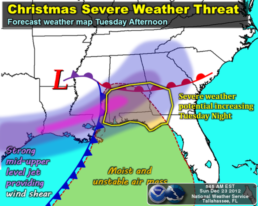
The SEVERE SIDE of the Christmas Storm
![]() by emcf30 Sun Dec 23, 2012 6:46 am
by emcf30 Sun Dec 23, 2012 6:46 am
The 18z GFS model is bad news for more people. The warm sector portion of this system is no joke if you clear out and have a good period of time to maximize destabilization. Guidance has been showing CAPEs near or exceeding 1000 j/kg over southern AL/FL Panhandle for several runs. There is even some mid level dry air that gets injected into the region. Discrete supercells are looking more like more of a threat as time goes on. You will also have high winds outside of convection in the warm sector with 925mb winds increasing to 40-50 kt.
With that being said, I very much dislike what the NAM and other models are showing at the moment. There is nothing worse to me that Christmas Day Tornadoes, and we will most likely be dealing with some here in the South. I am going to start the Significant Tornado Potential animation to the point where the Low will start to develop.

Here is a snap shot of the Severe Potential also.

On little close up snap shot of Gomeys area for Tornado Potential

The latest Euro looks wicked. SLP in southeast AR at 998mb. 850mb @ 10c to Huntsville, 850mb winds @ 50knts SW over the warm sector. 500mb looks like supercells for southern MS, southern/central AL Tuesday afternoon and evening with threat spreading into west/central, southwest GA becoming more linear overnight.


The favorable setup in the upper levels has not gone away with recent model runs, with the H5 jet punching straight into the warm sector with impressive diffluence aloft thanks to the s/w becoming increasingly negatively tilted with time. Obviously, the low level and deep layer shear look to be non-issues with a 40-60 kt LLJ shifting eastward across the Gulf Coast states, with long, hooked hodographs showing up in forecast soundings around the area. Shear vectors look favorable for fast-moving discrete supercells as well, being oriented essentially perpendicular to the incoming front. Thermodynamically, several things still need to be worked out, including the amount of coastal convection, leftover cloud cover and the warm sector showers from warm FROPA (and also how far north the WF gets). I will say, that the cold mid level temps will make it harder than normal to break this setup instability wise should the appropriate low level heating take place. The mid level dry punch also adds another dangerous element to this combination, as it may wipe out a larger section of any possibly inhibition rather quickly and initiate clusters of discrete cells, which would quickly intensify given rather impressive mid level lapse rates and very strong deep layer shear.
Regardless of what this turns out to be, now is the time to begin preparing for a rough Christmas Day across the south, inform your families of the potential, and remember to remain vigilant (a weather radio would be perfect). Hopefully if this does get hairy, which I will say there is a better chance of happening than most other times at this time of year, everybody will be prepared. And Gomey, please do not try to sleep through this one. If you hear your Tornado Siren go off, get up and check the situation out.
Let look at what some of the experts are saying now that the NAM is running the storm.
Fred Gossage 30/40 TV Met who we all saw during the Tuscaloosa / Birmingham Tornado
The threat of severe weather for Alabama on Christmas day and Christmas night appears to be increasing. Highest risk area includes communities like Guin, Double Springs, Cullman, Guntersville, Centre, Fayette, Jasper, Oneonta, Gadsden, Carrollton, Tuscaloosa, Birmingham, Pell City, Anniston, Helfin, Livingston, Greensboro, Centreville, Alabaster, Clanton, Sylacauga, Talladega, Lineville, Wedowee, Demopolis, Prattville, Wetumpka, Alex City, Montgomery, Auburn, and areas further southward... straight to the coast. Storms will have a threat of damaging winds and tornadoes... and a few long-track, strong tornadoes are possible. The greatest threat to the state, overall, will come from about 3:00 pm Tuesday until about 3:00 am Wednesday morning. PLEASE be weather aware across Alabama, especially since many of us will be traveling and visiting family and friends during this time. This is a dangerous, potentially higher-end type severe weather threat to the state of Alabama!
This is the real deal, folks. The main question will be where does the front stall out before Tuesday.... and then how early does the rain mass north of that warm front lift out to the north. The 06Z NAM continued the trend of previous runs, and of the Euro, in tracking the low further northwest... and bringing the higher instability further north. MLCAPE values of 750-900 j/kg now reach Lawrenceburg and Waynesboro, TN by 9 pm Tuesday. The previously mentioned mesoscale issues will need to be worked out, especially as we get closer to nowcasting time, but the threat of severe weather for ALL of Alabama is significantly increasing.... and this includes the threat of long-tracked, mid-to-upper end tornadoes.... especially U.S. 278 and south.
The higher low-level shear is going to be Montgomery northward. Getting adequate instability into the northern half of the state (and all it takes is 500-700 j/kg of SBCAPE... we're talking about 750-1000 further north now) increases the long-track tornado risk with the overall storm system as a whole.... not just for areas to the south. Getting that instability further north means the system, overall, is more likely to spit out that breed of tornado.....
NWS Tallahassee
he severe weather threat will increase on Christmas Day and Night, or Tuesday and Tuesday Night. Severe thunderstorms will be possible starting Tuesday afternoon in the western Florida Panhandle and southeast Alabama. The severe weather threat is not expected to increase for southwest Georgia and the Florida Big Bend until after midnight Tuesday Night as a cold front finally sweeps through the area. While there is still some uncertainty as to how exactly the storms will evolve, the environment should be favorable for severe thunderstorms. The primary threat will be damaging winds, with isolated tornadoes also possible. Monitor the forecast over the next couple days as the details about the specific severe weather threat is refined.
The main story will be related to the evolving storm system on
Christmas Day. This will develop out of a potent shortwave trough
digging through the interior West late Monday, and ejecting east
into the Arklatex on Tuesday. The majority of model guidance now
indicates rapid cyclogenesis, with low-level cyclone developing
from central Texas Christmas morning, to central Tennessee by
Christmas Night. The net result should be highly ageostrophic
flow, with strong surface pressure falls over the Southeast US
backing (and strengthening) the near-surface flow. At the same
time, and as a consequence of the strength of the digging wave and
mid-level temperature advection, a powerful mid-level jet streak
is projected to develop along the Gulf coast states. Operational
model guidance suggests that the 700mb flow near the base of the
trough could be as strong as 70-75 knots. GEFS mean wind fields
between 925mb and 700mb are, at their maxima, 2.5 to 3.5 standard
deviations stronger than normal. All of this will contribute to
expanding hodographs and an increasingly impressive shear profile
by 00z 26 December.
In combination with the impressive shear profiles, model forecasts
currently indicate more-than-adequate instability along the Gulf
coast, with the ECMWF, NAM, and GFS all showing MLCAPE values at
least reaching 300-400 j/kg across at least a portion of our area.
Some values are closer to double that, and the 03z SREF shows a
70% probability of MLCAPE values exceeding 500 j/kg over the SW
part of our forecast area. What may ultimately help sustain more
instability in this case than some of our cool-season severe
weather events are the mid-level lapse rates. The NAM, GFS, and
ECMWF all show an elevated mixed layer / plume of steep 700-500mb
lapse rates wrapping around the base of the trough and into our
area - emanating off the Mexican plateau.
The juxtaposition of strong shear and adequate instability will
place us in a favorable parameter space for severe weather, as
well as supercells. As the SPC SWODY3 alludes to, the ultimate
magnitude of the tornado threat will depend on convective mode.
However, even in the event of a QLCS, the low-level wind fields
appear to be strong enough to support a damaging wind threat
eastward into our area overnight. Therefore, concern is increasing
for a nocturnal severe weather event on Christmas Night along the
eastern Gulf coast - including our area. It should also be noted
that instability and shear are expected to increase sufficiently
by Tuesday afternoon (Christmas Day) over the western half of our
area to support a secondary severe weather threat before the
arrival of the main forcing and surface cold front. We will begin
to highlight the possibility of severe weather more prominently in
our products. Stay tuned for updates as the forecast becomes
refined more in the coming days.
NWS Mobile
SPECIAL WEATHER STATEMENT
NATIONAL WEATHER SERVICE MOBILE AL
651 PM CST SAT DEC 22 2012
...SEVERE STORMS POSSIBLE ON CHRISTMAS...
A POWERFUL LOW PRESSURE SYSTEM IS EXPECTED TO MOVE FROM TEXAS TO ACROSS
NORTHERN MISSISSIPPI-ALABAMA ON CHRISTMAS AND BRING A STRONG COLD
FRONT THROUGH THE AREA. UNSEASONABLY WARM...MOIST AND UNSTABLE AIR
WILL MEANWHILE SURGE INTO THE REGION AHEAD OF THE FRONT...AND YOUR
FORECASTERS AT THE NATIONAL WEATHER SERVICE OFFICE IN MOBILE AS WELL
AS THE STORM PREDICTION CENTER SEE THAT A SUBSTANTIAL SEVERE WEATHER
THREAT IS POSSIBLE FOR THE AREA ON CHRISTMAS.
THE CURRENT THINKING IS THAT THUNDERSTORMS WILL DEVELOP ACROSS THE
AREA THROUGH THE MORNING AND AFTERNOON HOURS AS THE WARM...MOIST AND
UNSTABLE AIR SURGES NORTHWARD. IN ADDITION...A LINE OF STORMS WILL
LIKELY FORM ALONG OR JUST EAST OF THE I-59 CORRIDOR BY MID-MORNING
AND MOVE QUICKLY EASTWARD TO BE LOCATED EAST OF I-65 BY DARK AND THEN
EAST OF A BRANTLEY/LUVERNE TO DESTIN LINE BY 8 PM.
ATMOSPHERIC CONDITIONS ARE FAVORABLE FOR SOME OF THE STORMS TO PRODUCE
ISOLATED TORNADOES AND DAMAGING STRAIGHT LINE WINDS. THE THREAT OF
SEVERE WEATHER IS EXPECTED TO END CHRISTMAS NIGHT AS THE STRONG COLD
FRONT MOVES THROUGH THE AREA.
STAY TUNED FOR FURTHER UPDATES ON THIS POTENTIALLY DANGEROUS WEATHER
SITUATION.

NWS Birmingham, AL
Media Briefing
http://www.srh.noaa.gov/bmx/?n=mmbrief
.DISCUSSION...
CIRRUS CLOUDS SPILLING OVER THE STATE THIS MORNING AHEAD OF A
SERIES OF SHORTWAVES THAT WILL BRING SHOWERS AND STORMS TO THE
AREA. THE FIRST WAVE WILL BE RATHER WEAK BUT WILL PUSH A COLD
FRONT INTO THE STATE ON MONDAY. SHOWERS AND A FEW THUNDERSTORMS
WILL BE POSSIBLE OVERNIGHT AND INTO CHRISTMAS EVE. THE MOST
SIGNIFICANT CHANGE ON TONIGHTS 00Z RUN WAS TO SHOW THE FRONT
STALLING WELL NORTH OF WHERE IT WAS FORECAST TO STALL ON PREVIOUS
RUNS. THE CURRENT PLACEMENT HAS IT SOMEWHERE BETWEEN BHM AND
MGM.
AS THE FRONT IS COMING TO AN ABRUPT STOP OVER THE STATE...A
VIGOROUS SHORTWAVE WILL BE EJECTING INTO WESTERN AND CENTRAL
TEXAS EARLY CHRISTMAS MORNING. STRONG SOUTHERLY FLOW WILL DEVELOP
OVER THE REGION AS THIS SYSTEM INTENSIFIES AND THE STALLED FRONT
SHOULD LIFT NORTHWARD AND MAY PASS ENTIRELY THROUGH THE CWA BY
EARLY TUESDAY EVENING. A SURFACE LOW OVER EASTERN TEXAS AND
WESTERN LOUISIANA WILL QUICKLY DEEPEN AND SHIFT NORTHEASTWARD
THROUGH NORTHERN MISSISSIPPI WITH A COLD FRONT PUSHING THROUGH THE
STATE OVERNIGHT CHRISTMAS NIGHT.
SHEAR HAS NEVER BEEN IN QUESTION WITH THIS STORM...WITH HELICITY
AND BULK SHEAR SUFFICIENT FOR TORNADOES...AND PERHAPS STRONGER
TORNADOES IF ISOLATED CELLS CAN DEVELOP. INSTABILITY HAS BEEN THE
LIMITING FACTOR BUT NOW APPEARS TO BE CATCHING UP WITH OTHER SEVERE
PARAMETERS DUE TO THE FRONT STALLING FARTHER NORTH AND CLEARING
THE AREA AS A WARM FRONT. WHILE THE HIGHEST SURFACE BASED
INSTABILITY REMAINS IN THE SOUTHERN HALF OF THE STATE...I DONT
THINK ANYONE IN OUR CWA IS WITHOUT SOME RISK OF SEVERE WEATHER AT
THIS POINT. BECAUSE OF THIS...WILL CHANGE THE HWO WORDING TO INCLUDE
THE ENTIRE CWA. WILL ALSO RAISE THE TORNADO CONFIDENCE HOWEVER I
COULD ALSO SEE THIS BECOMING A DAMAGING WIND EVENT AS IT
TRANSITIONS INTO THE STATE. CURRENTLY...THE SEVERE WEATHER THREAT
COULD BEGIN EARLY AFTERNOON CHRISTMAS DAY AND END AS LATE AS EARLY
MORNING WEDNESDAY FOR FAR EASTERN ALABAMA.
ON THE BACK SIDE OF THIS SYSTEM IS SOME VERY COLD AND POSSIBLY
FROZEN PRECIPITATION THAT WILL LIFT THROUGH THE NORTHERN THIRD OF
THE AREA ON WEDNESDAY MORNING. DID NOT MENTION ANY WINTER
PRECIPITATION AT THIS POINT AS THE AVAILABLE MOISTURE IS VERY
SHALLOW. WHATEVER FALLS WILL NOT HAVE ANY IMPACT TO SURFACE
CONDITIONS OTHER THAN TO KEEP THE WEATHER VERY RAW ON WEDNESDAY.
TEMPERATURES ACROSS THE NORTH MAY BREAK 40 DEGREES FOR AN HOUR OR
TWO WITH MID TO UPPER 40S IN THE SOUTHEAST NEAR TROY AND EUFAULA.
So, this just looks at the severe side. The Winter side looks as equally impressive for Many parts of the region.
emcf30- Posts : 975
Reputation : 10
Join date : 2012-07-16
Age : 93
Re: Time is finally nearing, Countdown to the first real Artic Front and Snow Event
![]() by emcf30 Sun Dec 23, 2012 6:52 am
by emcf30 Sun Dec 23, 2012 6:52 am
SPECIAL WEATHER STATEMENT
NATIONAL WEATHER SERVICE MEMPHIS TN
422 AM CST SUN DEC 23 2012
ARZ008-009-017-018-026>028-035-036-048-049-058-MOZ113-115-MSZ001>017-
020>024-TNZ001>004-019>021-048>055-088>092-232200-
ALCORN-BENTON-CALHOUN-CARROLL-CHESTER-CHICKASAW-CLAY-COAHOMA-
CRAIGHEAD-CRITTENDEN-CROCKETT-CROSS-DECATUR-DESOTO-DUNKLIN-DYER-
FAYETTE-GIBSON-GREENE-HARDEMAN-HARDIN-HAYWOOD-HENDERSON-HENRY-
ITAWAMBA-LAFAYETTE-LAKE-LAUDERDALE-LAWRENCE-LEE(AR)-LEE(MS)-MADISON-
MARSHALL-MCNAIRY-MISSISSIPPI-MONROE-OBION-PANOLA-PEMISCOT-PHILLIPS-
POINSETT-PONTOTOC-PRENTISS-QUITMAN-RANDOLPH-SHELBY-ST. FRANCIS-
TALLAHATCHIE-TATE-TIPPAH-TIPTON-TISHOMINGO-TUNICA-UNION-WEAKLEY-
YALOBUSHA-
422 AM CST SUN DEC 23 2012
...A SIGNIFICANT WINTER STORM MAY IMPACT PORTIONS OF THE MIDSOUTH
LATE TUESDAY AND EARLY WEDNESDAY MORNING...
A DEEP UPPER LEVEL LOW PRESSURE SYSTEM WILL LIFT FROM THE SOUTHERN
PLAINS INTO THE MIDSOUTH ON TUESDAY...CHRISTMAS DAY. PRECIPITATION
WILL INITIALLY OCCUR AS RAIN...WITH A FEW THUNDERSTORMS POSSIBLE
OVER NORTH MISSISSIPPI AND SOUTHWEST TENNESSEE.
AS TEMPERATURES FALL DURING TUESDAY AFTERNOON... PRECIPITATION
WILL LIKELY CHANGE TO SNOW OVER NORTHEAST ARKANSAS AND THE MISSOURI
BOOTHEEL. BY TUESDAY EVENING...RAIN WILL LIKELY CHANGE TO SNOW
FURTHER SOUTH TOWARD THE MEMPHIS METRO AND NORTH MISSISSIPPI. BRIEF
PERIODS OF SLEET MAY PRECEDE THE CHANGE OVER TO SNOW.
THERE IS STILL UNCERTAINTY REGARDING THE TRACK AND INTENSITY OF
THE WINTER STORM SYSTEM. BUT IT APPEARS EASTERN ARKANSAS...THE
MISSOURI BOOTHEEL AND NORTHWEST TENNESSEE WILL HAVE THE BEST
CHANCE OF ACCUMULATING SNOWS THROUGH WEDNESDAY MORNING. IN
ADDITION...STRONG WINDS MAY REDUCE VISIBILITIES WHERE SNOW IS
OCCURRING TUESDAY NIGHT AND EARLY WEDNESDAY.
A WINTER STORM WATCH MAY BE ISSUED LATER TODAY OR TONIGHT...ONCE
THE DETAILS OF THE STORM SYSTEM COME INTO CLEARER FOCUS.

emcf30- Posts : 975
Reputation : 10
Join date : 2012-07-16
Age : 93
Re: Time is finally nearing, Countdown to the first real Artic Front and Snow Event
![]() by emcf30 Sun Dec 23, 2012 7:04 am
by emcf30 Sun Dec 23, 2012 7:04 am


DAY 3 CONVECTIVE OUTLOOK
NWS STORM PREDICTION CENTER NORMAN OK
0229 AM CST SUN DEC 23 2012
VALID 251200Z - 261200Z
...THERE IS A SLGT RISK OF SVR TSTMS ACROSS PARTS OF THE SRN
PLAINS...LOWER MS VALLEY AND CNTRL GULF COAST STATES...
...GULF COAST STATES...
AN IMPRESSIVE UPPER-LEVEL SYSTEM IS FORECAST TO MOVE EWD INTO THE
SRN PLAINS EARLY TUESDAY MORNING AS THE EXIT REGION OF A POWERFUL
MID-LEVEL JET MOVES INTO THE GULF COAST STATES. AHEAD OF THE
SYSTEM...MOISTURE IS FORECAST TO RETURN NWD INTO THE LOWER MS VALLEY
AND CNTRL GULF COAST STATES WITH MODERATE INSTABILITY DEVELOPING
ACROSS THE SRN AND WRN PART OF THE SLIGHT RISK AREA EARLY IN THE DAY
ON TUESDAY. A CLUSTER OF THUNDERSTORMS OR SQUALL-LINE MAY BE ALREADY
DEVELOPED BY DAYBREAK ON TUESDAY ACROSS EAST TX WITH ADDITIONAL
STORMS POSSIBLY ONGOING ACROSS THE LOWER MS VALLEY. MODEL FORECASTS
INCREASE CONVECTIVE COVERAGE ACROSS THE LOWER MS VALLEY AND APPEAR
TO MOVE A WELL-DEVELOPED MCS EWD ACROSS THE REGION DURING THE DAY.
FORECAST SOUNDINGS AT MIDDAY TUESDAY IN THE LOWER MS VALLEY DEVELOP
AN IMPRESSIVE SHEAR ENVIRONMENT AS THE MID-LEVEL JET APPROACHES THE
REGION FROM THE WEST. NAM FORECAST SOUNDINGS VALID TUESDAY AT 21Z
JUST SOUTHWEST OF JACKSON MS SHOW MLCAPE VALUES AROUND 1500 J/KG
WITH ABOUT 60 KT OF DEEP LAYER SHEAR. THIS COMBINED WITH 0-3 KM
STORM RELATIVE HELICITIES AROUND 400 M2/S2 COULD BE FAVORABLE FOR
SUPERCELLS AND TORNADOES. IF MANY CELLS CAN REMAIN DISCRETE...THEN
CONDITIONS COULD ALSO BE FAVORABLE FOR STRONG TORNADOES AS THE
LOW-LEVEL JET MOVES EWD ACROSS THE CNTRL GULF COAST STATES FROM
TUESDAY MORNING INTO THE AFTERNOON. AT THIS POINT...THE POTENTIAL
FOR WIDESPREAD WIND DAMAGE APPEARS JUST AS VIABLE. THE MAGNITUDE OF
THESE THREATS MAY DEPEND UPON THE DOMINANT STORM MODE. IF THE
FAVORED MODE ENDS UP BEING LINEAR...THEN WIND DAMAGE COULD BE THE
GREATER THREAT.
FORECAST SOUNDINGS ACROSS THE LOWER MS VALLEY AND CNTRL GULF COAST
STATES TUESDAY INTO TUESDAY NIGHT SHOW POTENTIAL FOR A SUBSTANTIAL
SEVERE WEATHER EVENT. THE COMBINATION OF SHEAR AND INSTABILITY
COMBINED WITH A POTENT WEATHER SYSTEM SUGGESTS A 30 PERCENT
PROBABILITY AND SIGNIFICANT SEVERE HATCHED AREA ARE WARRANTED. THE
SEVERE THREAT SHOULD CONTINUE INTO TUESDAY EVENING AND POSSIBLY INTO
THE OVERNIGHT PERIOD AS THE UPPER-LEVEL TROUGH MOVES QUICKLY EWD
ACROSS THE GULF COAST STATES.
..BROYLES.. 12/23/2012
Ripe for Tornadoes

emcf30- Posts : 975
Reputation : 10
Join date : 2012-07-16
Age : 93
Re: Time is finally nearing, Countdown to the first real Artic Front and Snow Event
![]() by emcf30 Sun Dec 23, 2012 7:06 am
by emcf30 Sun Dec 23, 2012 7:06 am

emcf30- Posts : 975
Reputation : 10
Join date : 2012-07-16
Age : 93
Re: Time is finally nearing, Countdown to the first real Artic Front and Snow Event
![]() by StAugustineFL Sun Dec 23, 2012 7:08 am
by StAugustineFL Sun Dec 23, 2012 7:08 am

StAugustineFL- Posts : 2231
Reputation : 64
Join date : 2012-07-17
Re: Time is finally nearing, Countdown to the first real Artic Front and Snow Event
![]() by emcf30 Sun Dec 23, 2012 7:11 am
by emcf30 Sun Dec 23, 2012 7:11 am

emcf30- Posts : 975
Reputation : 10
Join date : 2012-07-16
Age : 93
Re: Time is finally nearing, Countdown to the first real Artic Front and Snow Event
![]() by StAugustineFL Sun Dec 23, 2012 7:40 am
by StAugustineFL Sun Dec 23, 2012 7:40 am

StAugustineFL- Posts : 2231
Reputation : 64
Join date : 2012-07-17
Re: Time is finally nearing, Countdown to the first real Artic Front and Snow Event
![]() by emcf30 Sun Dec 23, 2012 8:06 am
by emcf30 Sun Dec 23, 2012 8:06 am

emcf30- Posts : 975
Reputation : 10
Join date : 2012-07-16
Age : 93
Re: Time is finally nearing, Countdown to the first real Artic Front and Snow Event
![]() by emcf30 Sun Dec 23, 2012 8:13 am
by emcf30 Sun Dec 23, 2012 8:13 am

emcf30- Posts : 975
Reputation : 10
Join date : 2012-07-16
Age : 93
Re: Time is finally nearing, Countdown to the first real Artic Front and Snow Event
![]() by emcf30 Sun Dec 23, 2012 8:32 pm
by emcf30 Sun Dec 23, 2012 8:32 pm
HPC latest and greatest. ( Subject to change )


emcf30- Posts : 975
Reputation : 10
Join date : 2012-07-16
Age : 93
Re: Time is finally nearing, Countdown to the first real Artic Front and Snow Event
![]() by emcf30 Sun Dec 23, 2012 8:35 pm
by emcf30 Sun Dec 23, 2012 8:35 pm
BY CHRISTMAS EVE...ALL EYES WILL TURN TOWARD TEXAS AS A DEVELOPING
LOW PRESSURE SYSTEM WILL BEGIN TO SPREAD RAIN INTO THE MIDSOUTH LATE
CHRISTMAS EVE INTO CHRISTMAS MORNING. THE TRACK OF THIS LOW PRESSURE
SYSTEM WILL BE CRUCIAL ON DETERMINING WHERE THE HEAVY SNOW FALLS.
THE ECMWF AND THE CMC CONTINUE TO TRACK THE SFC LOW FROM CENTRAL
TEXAS TO NEAR NASHVILLE. THE GFS TRACKS THE SFC LOW A TAD FURTHER
NORTH WHILE THE NAM IS MUCH FURTHER NORTH WITH THE TRACK FROM
NORTH TEXAS TO NEAR CLARKSVILLE TENNESSEE. FOR THIS FORECAST WILL
BE LEANING TOWARD THE GFS SINCE IT IS THE MIDDLE OF THE ROAD
SOLUTION. WITH THE GFS SOLUTION...NORTHEAST ARKANSAS AND THE
MISSOURI BOOTHEEL WILL HAVE THE BEST CHANCES FOR HEAVY SNOW.
AMOUNTS COULD RANGE BETWEEN 4-8 INCHES WITH MOST OF THE SNOW
OCCURRING BETWEEN 6 PM AND MIDNIGHT CHRISTMAS NIGHT. SOUTHEAST OF
THIS AREA...THERE WILL BE A SHARP CUT OFF FROM SNOW ACCUMULATIONS
OF 3 INCHES TO NOTHING AS THE DRY SLOT WILL LIKELY MOVE INTO
MEMPHIS AND MUCH OF WEST TENNESSEE AND NORTH MISSISSIPPI. THUS
MUCH OF SHELBY COUNTY WILL LIKELY SEE LITTLE OR NO SNOW
ACCUMULATION. ANY SNOW THAT IS OCCURRING CHRISTMAS NIGHT WILL
TAPER OFF BY SUNRISE. WILL ISSUE A WINTER STORM WATCH FOR
NORTHEAST ARKANSAS AND THE MISSOURI BOOTHEEL FROM 3 PM CHRISTMAS
DAY THROUGH 6 AM WEDNESDAY.
COLD HIGH PRESSURE WILL SETTLE OVER THE REGION FOR WEDNESDAY
AFTERNOON INTO THURSDAY.
ON FRIDAY...ANOTHER OVERRUNNING PATTERN WILL SET UP OVER THE
MIDSOUTH AS A SFC LOW DEVELOPS IN THE REGION. MODELS DIFFER ON
EXACTLY WHERE AND PRECIP TYPE COULD BE AN ISSUE DEPENDING ON HOW
MUCH COLD AIR REMAINS AROUND AND WHERE EXACTLY THE LOW TRACKS.
STAY TUNED.
HIGH PRESSURE WILL THEN BUILD IN FOR NEXT WEEKEND KEEPING
CONDITIONS BELOW NORMAL AND DRY.
emcf30- Posts : 975
Reputation : 10
Join date : 2012-07-16
Age : 93
Re: Time is finally nearing, Countdown to the first real Artic Front and Snow Event
![]() by emcf30 Mon Dec 24, 2012 4:10 am
by emcf30 Mon Dec 24, 2012 4:10 am

...LOWER MS VALLEY/GULF COAST STATES...
AN IMPRESSIVE UPPER-LEVEL SYSTEM IS FORECAST TO MOVE ACROSS THE SRN
PLAINS INTO THE LOWER MS VALLEY ON TUESDAY. A POWERFUL MID-LEVEL JET
IN THE BASE OF THE UPPER-LEVEL SYSTEM WILL TRANSLATE QUICKLY EWD
OVER A MOISTENING WARM SECTOR RESULTING IN THE POTENTIAL FOR A
SIGNIFICANT SEVERE WEATHER EVENT ACROSS PARTS OF THE LOWER MS VALLEY
AND CNTRL GULF COAST STATES. AS THE UPPER-LEVEL TROUGH APPROACHES
THE REGION...MODEL FORECASTS MOVE A BAND OF STRONG LARGE-SCALE
ASCENT QUICKLY EWD ACROSS CNTRL TX EARLY TUESDAY MORNING WHICH
COINCIDES WITH A MOISTENING BOUNDARY LAYER ACROSS MUCH OF THE TX
COASTAL PLAINS. IN RESPONSE...THUNDERSTORM DEVELOPMENT SHOULD BE
UNDERWAY AT DAYBREAK ON TUESDAY WITH A CLUSTER OF STRONG TO
POTENTIALLY SEVERE STORMS MOVING ENEWD FROM SE TX INTO THE LOWER MS
VALLEY AROUND MIDDAY.
FORECAST SOUNDINGS AT VICKSBURG AND JACKSON MS ON TUESDAY GRADUALLY
DEVELOP MODERATE INSTABILITY WITH SFC DEWPOINTS REACHING THE LOWER
TO MID 60S F. THIS COMBINED WITH STRENGTHENING DEEP LAYER SHEAR AS
0-6 KM SHEAR APPROACHES 60 KT BY EARLY AFTERNOON SHOULD BE FAVORABLE
FOR SUPERCELLS AND TORNADOES. 0-3 KM STORM RELATIVE HELICITIES OF
350 TO 400 M2/S2 SHOULD BE SUPPORTIVE OF STRONG TORNADOES WITH THE
GREATEST THREAT ALONG A CORRIDOR FROM NEAR LAKE CHARLES LA TUESDAY
MORNING ACROSS SCNTRL MS INTO WCNTRL AL BY TUESDAY EVENING.
INSTABILITY...MOISTURE AND SHEAR PROFILES SUGGEST THAT ANY MCS THAT
BECOMES WELL-ORGANIZED COULD CONTAIN A TORNADO THREAT FOR AN
EXTENDED PERIOD. FOR THIS REASON...LONG TRACK TORNADOES COULD OCCUR
WITH SUPERCELLS THAT REMAIN DISCRETE AND MOVE ALONG THE NRN EDGE OF
MODERATE INSTABILITY. IN ADDITION...WIND DAMAGE WILL BE LIKELY WITH
LINE-SEGMENTS THAT ORGANIZE ON THE LEADING EDGE OF THE MCS. A THREAT
FOR WIDESPREAD WIND DAMAGE MAY DEVELOP ACROSS THE REGION TUESDAY
WITH WIND GUSTS OVER 70 KT POSSIBLE WITH BOWING SEGMENTS EMBEDDED IN
THE LINE. IF A WELL-DEVELOPED AND FAST MOVING SQUALL-LINE
ORGANIZES...THEN THE WIND DAMAGE THREAT COULD BECOME SUBSTANTIAL.
THE THREAT FOR SEVERE STORMS SHOULD CONTINUE THROUGH MUCH OF THE
OVERNIGHT PERIOD REACHING THE SRN APPALACHIAN MTNS AND ERN GULF
COAST STATES LATE TUESDAY NIGHT.
..BROYLES.. 12/24/2012

...THERE IS A SLGT RISK OF SVR TSTMS ACROSS PARTS OF THE ERN GULF
COAST STATES...FL PENINSULA...CAROLINAS AND MID-ATLANTIC...
...CAROLINAS/ERN GULF COAST STATES/MID-ATLANTIC...
AN IMPRESSIVE NEGATIVELY-TILTED UPPER-LEVEL SYSTEM IS FORECAST TO
MOVE QUICKLY NEWD ACROSS THE ATLANTIC COASTAL REGION ON WEDNESDAY.
AN UPPER-LEVEL LOW OVER THE MID MS VALLEY AT DAYBREAK ON WEDNESDAY
SHOULD MOVE NEWD ACROSS THE OH VALLEY AS A SLAB OF VERY STRONG
LARGE-SCALE ASCENT MOVES FROM THE ERN GULF COAST STATES EWD ACROSS
THE CAROLINAS WEDNESDAY AFTERNOON. DUE TO THE STRONG FORCING...A
WELL-DEVELOPED SQUALL-LINE SHOULD BE ONGOING AT 12Z ON WEDNESDAY
WITH THIS LINEAR CONVECTIVE SYSTEM REMAINING INTACT ALL THE WAY TO
THE COAST.
FORECAST SOUNDINGS AT 21Z/WED AHEAD OF THE SQUALL-LINE IN ERN NC AND
NCNTRL SC SHOW INCREASING INSTABILITY DURING THE LATE MORNING AND
EARLY AFTERNOON WITH SFC DEWPOINTS REACHING THE LOWER 60S F. THIS
MAY ALLOW MODERATE INSTABILITY TO DEVELOP ACROSS PARTS OF THE ERN
CAROLINAS WEDNESDAY AFTERNOON. IN ADDITION...A WELL-DEVELOPED
LOW-LEVEL JET COMBINED WITH A POWERFUL MID-LEVEL JET WRAPPING AROUND
THE UPPER-LEVEL LOW WILL CREATE STRONG DEEP LAYER SHEAR PROFILES
FAVORABLE FOR SEVERE STORMS. ACROSS MUCH OF THE REGION...WINDS IN
THE BOUNDARY LAYER ARE FORECAST TO EXCEED 50 KT JUST ABOVE THE SFC
WHICH SHOULD ENABLE ANY LINE OF STORMS TO BE EFFICIENT AT PRODUCING
WIND DAMAGE. IF DISCRETE CELLS CAN INITIATE AHEAD OF THE APPROACHING
SQUALL-LINE...THEN A SUBSTANTIAL TORNADO THREAT COULD ALSO DEVELOP
WEDNESDAY AFTERNOON WITH THE POTENTIAL FOR A STRONG TORNADO.
CONSIDERING THE STRENGTH OF THE UPPER-LEVEL SYSTEM WHICH COMBINED
WITH MODERATE INSTABILITY AND STRONG DEEP LAYER SHEAR...ANY SEVERE
THREAT THAT DEVELOPS ACROSS THE CAROLINAS COULD BECOME ENHANCED. FOR
THIS REASON...A 30 PERCENT SEVERE PROBABILITY WITH A SIGNIFICANT
HATCHED AREA APPEARS WARRANTED.
FURTHER TO THE NORTH ACROSS THE MID-ATLANTIC...ANY SEVERE THREAT
WITH THE LINE OF STORMS SHOULD BE MORE ISOLATED DUE TO WEAKENING
INSTABILITY WITH NWD EXTENT. TO THE SOUTH ACROSS ERN GA AND NRN
FL...A SUBSTANTIAL WIND DAMAGE THREAT COULD EXIST BUT THE THREAT
SHOULD DECREASE WITH SWD EXTENT DUE TO WEAKER LARGE-SCALE ASCENT AND
DEEP LAYER SHEAR.
..BROYLES.. 12/24/2012
emcf30- Posts : 975
Reputation : 10
Join date : 2012-07-16
Age : 93
Re: Time is finally nearing, Countdown to the first real Artic Front and Snow Event
![]() by StAugustineFL Mon Dec 24, 2012 7:21 am
by StAugustineFL Mon Dec 24, 2012 7:21 am
Also checked some of the winter storm watches. Looks like SE MO and SW IL are in for 10-15" of snow.
StAugustineFL- Posts : 2231
Reputation : 64
Join date : 2012-07-17
Re: Time is finally nearing, Countdown to the first real Artic Front and Snow Event
![]() by emcf30 Mon Dec 24, 2012 7:35 am
by emcf30 Mon Dec 24, 2012 7:35 am
StAugustineFL wrote:Kinda ironic you posted that E. When I woke up this morning I was wondering if there would've been an upgrade with the strong wording the past couple of days. I hope it turns out to be a bust.
Also checked some of the winter storm watches. Looks like SE MO and SW IL are in for 10-15" of snow.
Unfortunately, It really not in the cards for this to be a bust. Hope things work out for the peeps in that area
emcf30- Posts : 975
Reputation : 10
Join date : 2012-07-16
Age : 93
Re: Time is finally nearing, Countdown to the first real Artic Front and Snow Event
![]() by StAugustineFL Mon Dec 24, 2012 10:06 am
by StAugustineFL Mon Dec 24, 2012 10:06 am
through Wednesday morning...
A Winter Storm Watch remains in effect from Tuesday evening
through Wednesday morning.
* Current indications are that the axis of heaviest snowfall will
be over southeast Missouri and southern Illinois. Snowfall
amounts of 10 to 15 inches are possible within this axis of
heavy snow. Any change in the forecast track of the low would
cause the heavy snow area to shift... so continue to monitor
updated forecasts.
* Snow is expected to begin early on Christmas night... possibly
starting late in the day over southeast Missouri. Heavy snow and
strong north winds from 20 to 30 mph will occur most of the
night. The snow will end early Wednesday... but strong winds will
continue.
* Intense snowfall rates and strong winds may cause very difficult
travel conditions. Visibility will be lower than one half
mile... with local whiteout conditions possible.
* Intense snowfall rates... along with blowing and drifting snow
could potentially make travel impossible. Winds will gust over
30 mph at times. This looks to be a particularly dangerous storm
system.
StAugustineFL- Posts : 2231
Reputation : 64
Join date : 2012-07-17
Re: Time is finally nearing, Countdown to the first real Artic Front and Snow Event
![]() by StAugustineFL Mon Dec 24, 2012 10:08 am
by StAugustineFL Mon Dec 24, 2012 10:08 am
THIS HAZARDOUS WEATHER OUTLOOK IS FOR CENTRAL MISSISSIPPI...
NORTHEAST LOUISIANA...AND EXTREME SOUTHEAST ARKANSAS.
.DAY ONE...TODAY AND TONIGHT
THE PROBABILITY FOR WIDESPREAD HAZARDOUS WEATHER IS LOW.
.DAYS TWO THROUGH SEVEN...TUESDAY THROUGH SUNDAY
SEVERE THUNDERSTORMS AND HEAVY RAINFALL WILL BE POSSIBLE CHRISTMAS
DAY AND EVENING AS A STRONG STORM SYSTEM MOVES ACROSS THE AREA.
THUNDERSTORMS WITH A SUBSTANTIAL RISK FOR DAMAGING WIND GUSTS IN
EXCESS OF 70 MPH...QUARTER SIZED HAIL AND TORNADOES COULD DEVELOP...
PARTICULARLY TO THE SOUTHEAST OF A WINNSBORO LOUISIANA TO JACKSON
AND DE KALB MISSISSIPPI LINE WHERE INSTABILITY WILL BE GREATEST. A
FEW STRONG AND LONG TRACK TORNADOES MAY DEVELOP. HEAVY RAINFALL OF
TWO TO THREE INCHES IS LIKELY WITH LOCALLY HEAVIER AMOUNTS POSSIBLE.
StAugustineFL- Posts : 2231
Reputation : 64
Join date : 2012-07-17
Re: Time is finally nearing, Countdown to the first real Artic Front and Snow Event
![]() by emcf30 Mon Dec 24, 2012 11:04 pm
by emcf30 Mon Dec 24, 2012 11:04 pm
emcf30- Posts : 975
Reputation : 10
Join date : 2012-07-16
Age : 93
Re: Time is finally nearing, Countdown to the first real Artic Front and Snow Event
![]() by emcf30 Mon Dec 24, 2012 11:07 pm
by emcf30 Mon Dec 24, 2012 11:07 pm
emcf30- Posts : 975
Reputation : 10
Join date : 2012-07-16
Age : 93
Re: Time is finally nearing, Countdown to the first real Artic Front and Snow Event
![]() by emcf30 Mon Dec 24, 2012 11:11 pm
by emcf30 Mon Dec 24, 2012 11:11 pm

emcf30- Posts : 975
Reputation : 10
Join date : 2012-07-16
Age : 93
Re: Time is finally nearing, Countdown to the first real Artic Front and Snow Event
![]() by emcf30 Tue Dec 25, 2012 3:19 am
by emcf30 Tue Dec 25, 2012 3:19 am

emcf30- Posts : 975
Reputation : 10
Join date : 2012-07-16
Age : 93
Re: Time is finally nearing, Countdown to the first real Artic Front and Snow Event
![]() by emcf30 Tue Dec 25, 2012 3:47 am
by emcf30 Tue Dec 25, 2012 3:47 am

emcf30- Posts : 975
Reputation : 10
Join date : 2012-07-16
Age : 93
Re: Time is finally nearing, Countdown to the first real Artic Front and Snow Event
![]() by emcf30 Tue Dec 25, 2012 7:32 am
by emcf30 Tue Dec 25, 2012 7:32 am
Awesome.You rarely see this in Tennessee:
Blizzard Warning
URGENT - WINTER WEATHER MESSAGE
NATIONAL WEATHER SERVICE MEMPHIS TN
417 AM CST TUE DEC 25 2012
...BLIZZARD CONDITIONS EXPECTED TO IMPACT PARTS OF THE MIDSOUTH
FROM LATE TODAY...THROUGH CHRISTMAS NIGHT AND INTO EARLY WEDNESDAY...
.A STRONG UPPER LEVEL LOW PRESSURE SYSTEM CURRENTLY ACROSS TEXAS
WILL TRACK INTO THE MIDSOUTH BY THIS EVENING. RAIN WILL SPREAD
OVER MOST OF THE MIDSOUTH THIS MORNING AND AFTERNOON. RAIN WILL
BEGIN TO CHANGE TO SNOW OVER NORTHEAST ARKANSAS AND THE MISSOURI
BOOTHEEL LATE THIS AFTERNOON...BEFORE CHANGING OVER TO ALL SNOW BY
EARLY EVENING. PERIODS OF HEAVY SNOW WILL BE POSSIBLE DURING THE
NIGHT WITH THE ADDED POSSIBILITY OF AN INITIAL ICE PELLET MIX. IN
ADDITIONAL TO THE HEAVY SNOW...STRONG NORTH WINDS GUSTING UP TO
45 MPH ARE EXPECTED...CAUSING SEVERE REDUCTIONS IN
VISIBILITIES...ALONG WITH BLOWING AND DRIFTING CONDITIONS.
ARZ027-028-035-MOZ115-TNZ001-002-019-251800-
/O.UPG.KMEG.WS.A.0002.121225T2100Z-121226T1200Z/
/O.NEW.KMEG.BZ.W.0001.121225T2100Z-121226T1500Z/
POINSETT-MISSISSIPPI-CROSS-PEMISCOT-LAKE-OBION-DYER-
INCLUDING THE CITIES OF...HARRISBURG...BLYTHEVILLE...WYNNE...
CARUTHERSVILLE...UNION CITY...DYERSBURG
417 AM CST TUE DEC 25 2012
...BLIZZARD WARNING IN EFFECT FROM 3 PM THIS AFTERNOON TO 9 AM
CST WEDNESDAY...
THE NATIONAL WEATHER SERVICE IN MEMPHIS HAS ISSUED A BLIZZARD
WARNING...WHICH IS IN EFFECT FROM 3 PM THIS AFTERNOON TO 9 AM CST
WEDNESDAY. THE WINTER STORM WATCH IS NO LONGER IN EFFECT.
* VISIBILITIES AT TIMES DOWN TO LESS THAN A QUARTER OF A MILE.
* SNOW ACCUMULATIONS...6 TO 10 INCHES...WITH LOCALLY HIGHER
AMOUNTS.
* TIMING...RAIN WILL CHANGE OVER TO SNOW THIS AFTERNOON AND INTO
THE EARLY EVENING HOURS. SNOW WILL BECOME HEAVY AT TIMES TONIGHT.
* WINDS...SUSTAINED WINDS AROUND 25 TO 30 MPH WITH GUSTS OF 35 TO
45 MPH.
* IMPACTS...SNOW AND BLOWING SNOW WILL SIGNIFICANTLY REDUCE
VISIBILITIES. TRAVEL WILL BECOME HAZARDOUS.
.PRECAUTIONARY/PREPAREDNESS ACTIONS...
A BLIZZARD WARNING MEANS SEVERE WINTER WEATHER CONDITIONS ARE
EXPECTED OR OCCURRING. FALLING AND BLOWING SNOW WITH STRONG WINDS
AND POOR VISIBILITIES ARE LIKELY. THIS WILL LEAD TO WHITEOUT
CONDITIONS...MAKING TRAVEL EXTREMELY DANGEROUS. DO NOT TRAVEL. IF
YOU MUST TRAVEL...HAVE A WINTER SURVIVAL KIT WITH YOU. IF YOU GET
STRANDED...STAY WITH YOUR VEHICLE.
&&
emcf30- Posts : 975
Reputation : 10
Join date : 2012-07-16
Age : 93
Re: Time is finally nearing, Countdown to the first real Artic Front and Snow Event
![]() by emcf30 Tue Dec 25, 2012 10:26 am
by emcf30 Tue Dec 25, 2012 10:26 am

emcf30- Posts : 975
Reputation : 10
Join date : 2012-07-16
Age : 93
Re: Time is finally nearing, Countdown to the first real Artic Front and Snow Event
![]() by scouter534 Wed Dec 26, 2012 5:58 am
by scouter534 Wed Dec 26, 2012 5:58 am

scouter534- Posts : 128
Reputation : 1
Join date : 2012-07-16
Age : 62
Location : Pompano Beach, FL
Re: Time is finally nearing, Countdown to the first real Artic Front and Snow Event
![]() by emcf30 Sat Dec 29, 2012 11:19 am
by emcf30 Sat Dec 29, 2012 11:19 am
» summer 2019 hurricane season
» April-May Florida weather and local events etc
» NASCAR 2019
» Late January through February outlook
» FLORIDA/ALABAMA AND THE HOLIDAY SEASON WEATHER
» NASCAR 2018
» CLOSED Florida/Alabama Blog - October Tropical Mischief