


CLOSED 5/8/2017 Florida/Alabama Weather Blog
:: Florida Blog
Page 8 of 13 •  1, 2, 3 ... 7, 8, 9 ... 11, 12, 13
 ![]()
Re: CLOSED 5/8/2017 Florida/Alabama Weather Blog
![]() by LargoFL Mon May 22, 2017 2:52 pm
by LargoFL Mon May 22, 2017 2:52 pm

LargoFL- Posts : 10724
Reputation : 130
Join date : 2017-03-05
Re: CLOSED 5/8/2017 Florida/Alabama Weather Blog
![]() by StAugustineFL Mon May 22, 2017 3:42 pm
by StAugustineFL Mon May 22, 2017 3:42 pm
East coast seabreeze passed to my west and is on a collision course with the west coast seabreeze and outflow boundaries. Could be quite a bump in storm coverage/intensity to my west in the next hour or two then they slide east. Fingers crossed.


StAugustineFL- Posts : 2231
Reputation : 64
Join date : 2012-07-17
Re: CLOSED 5/8/2017 Florida/Alabama Weather Blog
![]() by LargoFL Tue May 23, 2017 4:42 am
by LargoFL Tue May 23, 2017 4:42 am
LargoFL- Posts : 10724
Reputation : 130
Join date : 2017-03-05
Re: CLOSED 5/8/2017 Florida/Alabama Weather Blog
![]() by LargoFL Tue May 23, 2017 5:20 am
by LargoFL Tue May 23, 2017 5:20 am
National Weather Service Tampa Bay Ruskin FL
457 AM EDT Tue May 23 2017
.SHORT TERM (Today-Wednesday)...
Some upper shortwave energy will move over the area later
this afternoon and help to enhance thunderstorm activity for
this afternoon and evening across the area. Additional upper
energy moving through the base of the trough will pass over
the state for Wednesday and allow for some strong to
possibly severe storms. Damaging winds will be the main
hazard with the storms, but an isolated tornado cannot be
ruled out. Heavy rains with the storms will also be
possible.
LargoFL- Posts : 10724
Reputation : 130
Join date : 2017-03-05
Re: CLOSED 5/8/2017 Florida/Alabama Weather Blog
![]() by LargoFL Tue May 23, 2017 5:24 am
by LargoFL Tue May 23, 2017 5:24 am
LargoFL- Posts : 10724
Reputation : 130
Join date : 2017-03-05
Re: CLOSED 5/8/2017 Florida/Alabama Weather Blog
![]() by LargoFL Tue May 23, 2017 7:05 am
by LargoFL Tue May 23, 2017 7:05 am
LargoFL- Posts : 10724
Reputation : 130
Join date : 2017-03-05

LargoFL- Posts : 10724
Reputation : 130
Join date : 2017-03-05
Re: CLOSED 5/8/2017 Florida/Alabama Weather Blog
![]() by LargoFL Tue May 23, 2017 7:31 am
by LargoFL Tue May 23, 2017 7:31 am
LargoFL- Posts : 10724
Reputation : 130
Join date : 2017-03-05
Re: CLOSED 5/8/2017 Florida/Alabama Weather Blog
![]() by severstorm Tue May 23, 2017 8:08 am
by severstorm Tue May 23, 2017 8:08 am
LargoFL wrote:Looks like Wednesday could be My storm day as that line of storms passes over tampa bay..lets watch and see how fast or slow it moves and I just hope no tornado's or real bad winds with it...and if Nam proves true, the line will come IN from the gulf here,being pushed eastward...have to watch out for any waterspouts coming ashore etc....interesting couple of days coming folks..heed your local warnings for your area and stay safe out there...sure would be great if it turns out to be a good rain event for those who really need the rain.
Morning All,
I had .08 in the bucket late last night. That gives me 2.06 for the month.
Looks like we could have some wild weather wed. night early thurs. morning.
Looking forward to the 2 to 3 inches of rain. Like Largo says NO TORNADOS!!!!!
Have a great day!
John Z-hills
severstorm- Posts : 331
Reputation : 14
Join date : 2017-03-14
Age : 61
Location : Zephyrhills
Re: CLOSED 5/8/2017 Florida/Alabama Weather Blog
![]() by waterdipper Tue May 23, 2017 8:22 am
by waterdipper Tue May 23, 2017 8:22 am
waterdipper- Posts : 324
Reputation : 18
Join date : 2017-03-15
Location : Somewhere between Cedar Key, Chiefland and Gainesville
Re: CLOSED 5/8/2017 Florida/Alabama Weather Blog
![]() by LargoFL Tue May 23, 2017 9:45 am
by LargoFL Tue May 23, 2017 9:45 am
good Morning John,yes could be some wild weather coming is right...stay alert and safe up there ok.severstorm wrote:LargoFL wrote:Looks like Wednesday could be My storm day as that line of storms passes over tampa bay..lets watch and see how fast or slow it moves and I just hope no tornado's or real bad winds with it...and if Nam proves true, the line will come IN from the gulf here,being pushed eastward...have to watch out for any waterspouts coming ashore etc....interesting couple of days coming folks..heed your local warnings for your area and stay safe out there...sure would be great if it turns out to be a good rain event for those who really need the rain.
Morning All,
I had .08 in the bucket late last night. That gives me 2.06 for the month.
Looks like we could have some wild weather wed. night early thurs. morning.
Looking forward to the 2 to 3 inches of rain. Like Largo says NO TORNADOS!!!!!
Have a great day!
John Z-hills
LargoFL- Posts : 10724
Reputation : 130
Join date : 2017-03-05
Re: CLOSED 5/8/2017 Florida/Alabama Weather Blog
![]() by LargoFL Tue May 23, 2017 9:47 am
by LargoFL Tue May 23, 2017 9:47 am
Good Morning WD,yeah I'm unsure what to expect today..solid overcast here and moisture clouds all streaming sort of northward here..stay alert and safe okwaterdipper wrote:Good morning all. Just had a brief (and I mean brief) downpour at work in Cedar Key. Looking at the current radar I hope this activity builds in the Gulf because at the moment it looks like the energy is moving northward into AL and GA. Hopefully a nice large area of moderate rain hits the entire peninsula and rains all day and night.
LargoFL- Posts : 10724
Reputation : 130
Join date : 2017-03-05
Re: CLOSED 5/8/2017 Florida/Alabama Weather Blog
![]() by LargoFL Tue May 23, 2017 9:48 am
by LargoFL Tue May 23, 2017 9:48 am
LargoFL- Posts : 10724
Reputation : 130
Join date : 2017-03-05
Re: CLOSED 5/8/2017 Florida/Alabama Weather Blog
![]() by LargoFL Tue May 23, 2017 9:52 am
by LargoFL Tue May 23, 2017 9:52 am
Tornado Warning
National Weather Service Tallahassee FL
834 AM CDT TUE MAY 23 2017
The National Weather Service in Tallahassee has issued a
* Tornado Warning for...
Southern Coffee County in southeastern Alabama...
Northwestern Geneva County in southeastern Alabama...
* Until 915 AM CDT
* At 834 AM CDT, a severe thunderstorm capable of producing a tornado
was located 7 miles south of Opp, moving northeast at 40 mph.
HAZARD...Tornado.
SOURCE...Radar indicated rotation.
IMPACT...Flying debris will be dangerous to those caught without
shelter. Mobile homes will be damaged or destroyed.
Damage to roofs, windows, and vehicles will occur. Tree
damage is likely.
* This dangerous storm will be near...
Elba around 905 AM CDT.
New Brockton around 915 AM CDT.
Other locations impacted by this tornadic thunderstorm include
Alberton, Richburg, Perry Store, Carl Folsom A/p, County Line,
Lucile, Rhoades, Ino, Turner Crossroads and Central City.
LargoFL- Posts : 10724
Reputation : 130
Join date : 2017-03-05
Re: CLOSED 5/8/2017 Florida/Alabama Weather Blog
![]() by LargoFL Tue May 23, 2017 10:02 am
by LargoFL Tue May 23, 2017 10:02 am
LargoFL- Posts : 10724
Reputation : 130
Join date : 2017-03-05
Re: CLOSED 5/8/2017 Florida/Alabama Weather Blog
![]() by LargoFL Tue May 23, 2017 10:05 am
by LargoFL Tue May 23, 2017 10:05 am
...WIDESPREAD HEAVY RAINFALL POSSIBLE LATE TONIGHT THROUGH
WEDNESDAY EVENING...
...STRONG TO SEVERE STORMS WILL ALSO BE POSSIBLE...
This Hazardous Weather Outlook is for Northeast Florida,
Southeast Georgia and the Adjacent Coastal Waters.
.DAY ONE...Today and Tonight...
Widespread heavy rainfall is expected in showers/thunderstorms
across portions of southeast Georgia today. Scattered to numerous
showers/storms in northeast Florida this afternoon will become
more widespread tonight.
There is a slight risk of severe thunderstorms in Southeast
Georgia this afternoon...and a marginal risk of severe storms in
northeast Florida this afternoon. Damaging winds and localized
flooding will be the main threats...however...Isolated Tornadoes
and large hail will also be possible.
Widespread heavy rainfall will be possible across portions of
northeast Florida tonight...particularly over the Suwannee Valley
Region.
LargoFL- Posts : 10724
Reputation : 130
Join date : 2017-03-05
Re: CLOSED 5/8/2017 Florida/Alabama Weather Blog
![]() by LargoFL Tue May 23, 2017 10:11 am
by LargoFL Tue May 23, 2017 10:11 am
LargoFL- Posts : 10724
Reputation : 130
Join date : 2017-03-05
Re: CLOSED 5/8/2017 Florida/Alabama Weather Blog
![]() by LargoFL Tue May 23, 2017 10:38 am
by LargoFL Tue May 23, 2017 10:38 am
LargoFL- Posts : 10724
Reputation : 130
Join date : 2017-03-05
Re: CLOSED 5/8/2017 Florida/Alabama Weather Blog
![]() by StAugustineFL Tue May 23, 2017 10:58 am
by StAugustineFL Tue May 23, 2017 10:58 am
Yesterday's storms did blow up along the seabreeze/outflow collision but just to my north by a few miles. A fairly widespread 1-2" fell. I had .04" which was just enough to temporarily wet the pavement.
StAugustineFL- Posts : 2231
Reputation : 64
Join date : 2012-07-17
Re: CLOSED 5/8/2017 Florida/Alabama Weather Blog
![]() by BillsfaninSoFla Tue May 23, 2017 2:31 pm
by BillsfaninSoFla Tue May 23, 2017 2:31 pm
How does is look for my area Largo?
BillsfaninSoFla- Posts : 1966
Reputation : 52
Join date : 2017-03-05
Re: CLOSED 5/8/2017 Florida/Alabama Weather Blog
![]() by LargoFL Tue May 23, 2017 3:06 pm
by LargoFL Tue May 23, 2017 3:06 pm
your in the marginal zone for possible severe storms Billsfan..BillsfaninSoFla wrote:Good afternoon. Nothing going on here except heat and humidity.
How does is look for my area Largo?
LargoFL- Posts : 10724
Reputation : 130
Join date : 2017-03-05
Re: CLOSED 5/8/2017 Florida/Alabama Weather Blog
![]() by LargoFL Tue May 23, 2017 3:15 pm
by LargoFL Tue May 23, 2017 3:15 pm
LargoFL- Posts : 10724
Reputation : 130
Join date : 2017-03-05
Re: CLOSED 5/8/2017 Florida/Alabama Weather Blog
![]() by LargoFL Tue May 23, 2017 3:17 pm
by LargoFL Tue May 23, 2017 3:17 pm
Tornado Watch Number 258
NWS Storm Prediction Center Norman OK
240 PM EDT Tue May 23 2017
The NWS Storm Prediction Center has issued a
* Tornado Watch for portions of
northern Florida
southeastern Georgia
central and southern South Carolina
Coastal Waters
* Effective this Tuesday afternoon and evening from 240 PM until
1100 PM EDT.
* Primary threats include...
A few tornadoes possible
Scattered damaging wind gusts to 70 mph possible
Isolated large hail events to 1.5 inches in diameter possible
LargoFL- Posts : 10724
Reputation : 130
Join date : 2017-03-05
Re: CLOSED 5/8/2017 Florida/Alabama Weather Blog
![]() by LargoFL Tue May 23, 2017 3:18 pm
by LargoFL Tue May 23, 2017 3:18 pm
LargoFL- Posts : 10724
Reputation : 130
Join date : 2017-03-05
Re: CLOSED 5/8/2017 Florida/Alabama Weather Blog
![]() by LargoFL Tue May 23, 2017 3:22 pm
by LargoFL Tue May 23, 2017 3:22 pm
significantly across the Nature Coast tonight, with the increasing
rain chances then spreading south to the Tampa Bay area toward
sunrise, and then across the remainder of the region during
Wednesday and Wednesday night. With regards to the severe threat it
now appears that the best chances for severe storms will be during
Wednesday afternoon and evening when a low level jet (45-50 knots)
and large scale forcing for ascent overspreads the region, however
some strong to severe storms will also be possible across the Nature
Coast tonight through Wednesday morning as the environment becomes
increasingly favorable for strong to severe storms. In addition to
the severe threat some locally heavy rainfall will be possible which
may produce some minor flooding of low lying and poor drainage
areas, as well as the ponding of water on roadways. Frequent deadly
lightning will also accompany the storms.
LargoFL- Posts : 10724
Reputation : 130
Join date : 2017-03-05
Re: CLOSED 5/8/2017 Florida/Alabama Weather Blog
![]() by LargoFL Tue May 23, 2017 3:26 pm
by LargoFL Tue May 23, 2017 3:26 pm

LargoFL- Posts : 10724
Reputation : 130
Join date : 2017-03-05
Re: CLOSED 5/8/2017 Florida/Alabama Weather Blog
![]() by LargoFL Tue May 23, 2017 3:29 pm
by LargoFL Tue May 23, 2017 3:29 pm
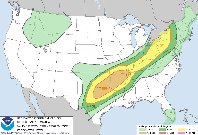
...A few storms possible northeastern areas of South Florida today...
...Strong to even severe storms possible late Wednesday into Thursday...
This hazardous weather outlook is for South Florida.
.DAY ONE...TODAY AND TONIGHT
Thunderstorms: There is a slight chance of thunderstorms this
afternoon over the northeastern areas of South Florida.
The primary impacts will be lightning strikes and locally heavy
rainfall.
.DAYS TWO THROUGH SEVEN...WEDNESDAY THROUGH MONDAY
The rip current risk may increase for the Gulf Coast beaches ahead
of a cold front Wednesday.
The Storm Prediction Center has highlighted portions of South
Florida around Lake Okeechobee into Collier County in a Slight Risk
for severe thunderstorms Wednesday into Thursday, and the remainder
of South Florida in a Marginal Risk for severe thunderstorms as a
cold front approaches the region. At the present time, damaging winds
and hail looks to be the primary threats, although an isolated
tornado or two cannot be ruled out. Interests in South Florida should
continue to monitor the forecast closely.
Isolated to thunderstorms are again possible across the region,
especially during the afternoon and evening hours, Friday through
Sunday.
LargoFL- Posts : 10724
Reputation : 130
Join date : 2017-03-05
Re: CLOSED 5/8/2017 Florida/Alabama Weather Blog
![]() by sangria Tue May 23, 2017 3:30 pm
by sangria Tue May 23, 2017 3:30 pm
I'm going to bust some Tampa area bubbles, but Aug's favorite map is the WPC 5 day precip.....

Now I need to go see what the models are showing

sangria- Admin
- Posts : 2345
Reputation : 55
Join date : 2012-07-16
Re: CLOSED 5/8/2017 Florida/Alabama Weather Blog
![]() by sangria Tue May 23, 2017 3:33 pm
by sangria Tue May 23, 2017 3:33 pm

sangria- Admin
- Posts : 2345
Reputation : 55
Join date : 2012-07-16
Re: CLOSED 5/8/2017 Florida/Alabama Weather Blog
![]() by LargoFL Tue May 23, 2017 3:34 pm
by LargoFL Tue May 23, 2017 3:34 pm

LargoFL- Posts : 10724
Reputation : 130
Join date : 2017-03-05
Re: CLOSED 5/8/2017 Florida/Alabama Weather Blog
![]() by sangria Tue May 23, 2017 3:36 pm
by sangria Tue May 23, 2017 3:36 pm

sangria- Admin
- Posts : 2345
Reputation : 55
Join date : 2012-07-16
Re: CLOSED 5/8/2017 Florida/Alabama Weather Blog
![]() by LargoFL Tue May 23, 2017 3:36 pm
by LargoFL Tue May 23, 2017 3:36 pm
good luck with the storms tomorrow San.sangria wrote:HRRR valid only through tomorrow morning at 7am EDT. Nice chances for those to the north....
LargoFL- Posts : 10724
Reputation : 130
Join date : 2017-03-05
Re: CLOSED 5/8/2017 Florida/Alabama Weather Blog
![]() by sangria Tue May 23, 2017 3:37 pm
by sangria Tue May 23, 2017 3:37 pm

sangria- Admin
- Posts : 2345
Reputation : 55
Join date : 2012-07-16
Re: CLOSED 5/8/2017 Florida/Alabama Weather Blog
![]() by LargoFL Tue May 23, 2017 3:38 pm
by LargoFL Tue May 23, 2017 3:38 pm
lol I'm in a dry spot again?...08??? lol I cannot win.sangria wrote:NAM total through Fri night at 7pm EDT....
LargoFL- Posts : 10724
Reputation : 130
Join date : 2017-03-05
Re: CLOSED 5/8/2017 Florida/Alabama Weather Blog
![]() by sangria Tue May 23, 2017 3:39 pm
by sangria Tue May 23, 2017 3:39 pm
LargoFL wrote:
good luck with the storms tomorrow San.
I think those from the Nature Coast north and then into NE FL will see the brunt of it.
sangria- Admin
- Posts : 2345
Reputation : 55
Join date : 2012-07-16
Re: CLOSED 5/8/2017 Florida/Alabama Weather Blog
![]() by sangria Tue May 23, 2017 3:40 pm
by sangria Tue May 23, 2017 3:40 pm
LargoFL wrote:
lol I'm in a dry spot again?...08??? lol I cannot win.
No No Largo, that's .8" not .08" for you!
The GFS is a little more generous to you though. :-)
sangria- Admin
- Posts : 2345
Reputation : 55
Join date : 2012-07-16
Re: CLOSED 5/8/2017 Florida/Alabama Weather Blog
![]() by StAugustineFL Tue May 23, 2017 3:53 pm
by StAugustineFL Tue May 23, 2017 3:53 pm
sangria wrote:LargoFL wrote:
good luck with the storms tomorrow San.
I think those from the Nature Coast north and then into NE FL will see the brunt of it.
We shall see. NFL was supposed to see the brunt of it the day you had 3.55". I had .03". Mother nature is interesting. My personal goal for this system is 2.26" which would put me to 3" for this mini wet period.
StAugustineFL- Posts : 2231
Reputation : 64
Join date : 2012-07-17
Re: CLOSED 5/8/2017 Florida/Alabama Weather Blog
![]() by StAugustineFL Tue May 23, 2017 3:57 pm
by StAugustineFL Tue May 23, 2017 3:57 pm
StAugustineFL- Posts : 2231
Reputation : 64
Join date : 2012-07-17
Re: CLOSED 5/8/2017 Florida/Alabama Weather Blog
![]() by StAugustineFL Tue May 23, 2017 4:07 pm
by StAugustineFL Tue May 23, 2017 4:07 pm
StAugustineFL- Posts : 2231
Reputation : 64
Join date : 2012-07-17
Re: CLOSED 5/8/2017 Florida/Alabama Weather Blog
![]() by sangria Tue May 23, 2017 4:08 pm
by sangria Tue May 23, 2017 4:08 pm
StAugustineFL wrote:
We shall see. NFL was supposed to see the brunt of it the day you had 3.55". I had .03". Mother nature is interesting. My personal goal for this system is 2.26" which would put me to 3" for this mini wet period.
Did I have 3.55" one day??? Is that supposed to be on my SS?
Last edited by sangria on Tue May 23, 2017 4:12 pm; edited 1 time in total
sangria- Admin
- Posts : 2345
Reputation : 55
Join date : 2012-07-16
Re: CLOSED 5/8/2017 Florida/Alabama Weather Blog
![]() by sangria Tue May 23, 2017 4:11 pm
by sangria Tue May 23, 2017 4:11 pm

SPC AC 231959
Day 1 Convective Outlook
NWS Storm Prediction Center Norman OK
0259 PM CDT Tue May 23 2017
Valid 232000Z - 241200Z
...THERE IS A SLIGHT RISK OF SEVERE THUNDERSTORMS FOR SOUTHEASTERN
GEORGIA AND THE SOUTH CAROLINA COASTAL PLAIN...
...THERE IS A SLIGHT RISK OF SEVERE THUNDERSTORMS FOR MUCH OF THE
TEXAS COASTAL PLAIN INTO SOUTH-CENTRAL TEXAS...
...THERE IS A MARGINAL RISK OF SEVERE THUNDERSTORMS FROM CENTRAL
TEXAS EASTWARD ALONG THE CENTRAL GULF COAST INTO COASTAL NORTH
CAROLINA...
...SUMMARY...
Isolated severe thunderstorms are possible over southeastern Georgia
and the South Carolina coastal plain through the early evening. A
few tornadoes are possible along with damaging gusts. Storms may
also impact parts of south-central Texas into Texas Gulf coastal
areas with a risk for severe wind and hail.
...Discussion...
The only substantial changes to the convective outlook include:
1) reducing severe probabilities across parts of AL-GA-SC to the
west and northwest of a cluster of strong to severe thunderstorms
this afternoon. A tornado or two will remain possible across the
coastal plain of SC and GA through the early evening within a
moist/sufficiently sheared environment.
2) Removing low-severe probabilities across parts of IL. Weak
instability and the lack of charge separation both indicate an
appreciable risk for marginally severe storms will be low enough to
not warrant a probability delineation.
..Smith.. 05/23/2017
.PREV DISCUSSION... /ISSUED 1123 AM CDT Tue May 23 2017/
...Synopsis...
Large-scale mid/upper troughing now encompasses much of the interior
U.S. from the Rockies to the Appalachians, and its positively tilted
axis may take on at least a bit more of a neutral tilt while
pivoting from the Plains into the Mississippi Valley through the
remainder of the period. As it does, models indicate that an
embedded lower/mid tropospheric cyclone will continue to gradually
redevelop south southeastward from the upper into middle Mississippi
Valley, perhaps supporting some consolidation and deepening of
surface low pressure along an associated front near/north of the
lower Ohio Valley by 12Z Tuesday.
A preceding frontal zone has already reached much of the Gulf coast
into south Atlantic coast region, with the boundary currently
stalled to the lee of the southern Appalachians, ahead of a weak
frontal wave now evolving across southern Alabama. This wave
accompanies one significant impulse embedded within the broader
scale cyclonic mid/upper flow field, which is forecast to continue
migrating east northeast of the lower Mississippi Valley, through
the southern Appalachians and southern/mid Atlantic coast region by
12Z Tuesday.
Upstream, an additional significant perturbation or two appear
likely to dig southeast of the south central high Plains before
turning eastward across the western Gulf coast/lower Mississippi
Valley region. Associated with these features, a reinforcing cold
front is already in the process of surging into central and
southwest Texas, and is expected to advance through the lower Rio
Grande Valley and Texas Gulf coast by the end of the period.
Aided by destabilization beneath cold mid-level air, the environment
along and ahead of the reinforcing front, from parts of the Upper
Midwest into south Texas, probably will become conducive to
scattered thunderstorm development today into tonight. However,
seasonably high moisture content air near/south of the lead frontal
zone appears to provide the focus for the most numerous thunderstorm
activity, across parts of the south Atlantic and eastern Gulf coast
states into the northern Gulf of Mexico.
...Eastern Gulf into south Atlantic coast states...
Lower/mid tropospheric lapse rates appear generally weak, but a
seasonably moist environment (surface dew points near 70F)
along/south of the stalled weak frontal zone across the region is
expected to become at least modestly unstable with daytime heating.
Coupled with enlarging low-level hodographs, associated with a 40-50
kt southwesterly 850 mb jet evolving near the frontal wave, the
environment near the northeastward advancing frontal wave appears
conducive to strong/severe storms with a risk for tornadoes and
potentially damaging surface gusts. The primary threat area now
appears to be evolving across southwestern Georgia, and is expected
to shift east northeastward through portions of the piedmont and
coastal plain of South Carolina by this evening.
...South central Texas into Texas Gulf coastal areas...
Residual modest boundary layer moisture, coupled with steepening
lapse rates associated with pre-frontal surface heating beneath
relatively cold air aloft, probably will contribute to sufficient
instability to support a risk for strong/severe storm development
late this afternoon and evening. Deep layer shear will be strong
enough beneath 40-50+ kt (and strengthening) cyclonic northwesterly
500 mb flow. Aided by forcing for ascent associated with an initial
perturbation approaching the region, one or two organizing storm
clusters appears possible, generally focused near the initially slow
moving/stalled frontal zone across mid (and perhaps portions of
upper) Texas coastal areas by this evening.
...North central Illinois...
There are at least some indications in latest model guidance that an
area of enhanced forcing for ascent will become focused across the
region by late afternoon, ahead of the digging mid-level cold core.
Depending on the degree of insolation and destabilization that can
take place by late afternoon, it may not be out of the question that
the environment could become conducive of convection with at least
marginal severe weather potential.
sangria- Admin
- Posts : 2345
Reputation : 55
Join date : 2012-07-16
Re: CLOSED 5/8/2017 Florida/Alabama Weather Blog
![]() by StAugustineFL Tue May 23, 2017 4:12 pm
by StAugustineFL Tue May 23, 2017 4:12 pm
StAugustineFL- Posts : 2231
Reputation : 64
Join date : 2012-07-17
Re: CLOSED 5/8/2017 Florida/Alabama Weather Blog
![]() by StAugustineFL Tue May 23, 2017 4:23 pm
by StAugustineFL Tue May 23, 2017 4:23 pm

StAugustineFL- Posts : 2231
Reputation : 64
Join date : 2012-07-17
Re: CLOSED 5/8/2017 Florida/Alabama Weather Blog
![]() by sangria Tue May 23, 2017 4:38 pm
by sangria Tue May 23, 2017 4:38 pm
sangria- Admin
- Posts : 2345
Reputation : 55
Join date : 2012-07-16
Re: CLOSED 5/8/2017 Florida/Alabama Weather Blog
![]() by sangria Tue May 23, 2017 4:43 pm
by sangria Tue May 23, 2017 4:43 pm
StAugustineFL wrote:I must say san is the most intelligent 4-5 year old I may have seen in my lifetime! (avatar picture)

sangria- Admin
- Posts : 2345
Reputation : 55
Join date : 2012-07-16
sangria- Admin
- Posts : 2345
Reputation : 55
Join date : 2012-07-16
Re: CLOSED 5/8/2017 Florida/Alabama Weather Blog
![]() by LargoFL Wed May 24, 2017 5:19 am
by LargoFL Wed May 24, 2017 5:19 am
FLC109-240930-
/O.NEW.KJAX.SV.W.0141.170524T0858Z-170524T0930Z/
BULLETIN - IMMEDIATE BROADCAST REQUESTED
Severe Thunderstorm Warning
National Weather Service Jacksonville FL
458 AM EDT WED MAY 24 2017
The National Weather Service in Jacksonville has issued a
* Severe Thunderstorm Warning for...
Southeastern St. Johns County in northeastern Florida...
* Until 530 AM EDT
* At 457 AM EDT, a severe thunderstorm was located near Saint
Augustine South, or near Saint Augustine, moving northeast at 30
mph.
HAZARD...60 mph wind gusts.
SOURCE...Radar indicated.
IMPACT...Expect damage to roofs, siding, and trees.
* Locations impacted include...
Saint Augustine, Saint Augustine Beach, Saint Augustine Shores,
Vilano Beach, Saint Augustine South, Butler Beach and Anastasia.
PRECAUTIONARY/PREPAREDNESS ACTIONS...
For your protection move to an interior room on the lowest floor of a
building.
&&
LargoFL- Posts : 10724
Reputation : 130
Join date : 2017-03-05
Re: CLOSED 5/8/2017 Florida/Alabama Weather Blog
![]() by LargoFL Wed May 24, 2017 5:22 am
by LargoFL Wed May 24, 2017 5:22 am
This Hazardous Weather Outlook is for West Central And Southwest
Florida.
.DAY ONE...Today and Tonight.
...THUNDERSTORM IMPACT...
Scattered to numerous thunderstorms are expected today.
Thunderstorms will be capable of producing strong gusty
winds...locally heavy rains...and frequent deadly lightning
strikes. A slight risk of strong to severe thunderstorms will be
possible today with a passing cold front.
...HIGH WIND IMPACT...
Strong and gusty winds in the 20 to 25 MPH range with higher gusts
will affect local area lakes. These strong and gusty winds will
create choppy and difficult boating conditions on area lakes.
Small boats will be especially prone to capsizing.
...COASTAL FLOOD IMPACT...
Conditions favorable for coastal flooding of 1 to 2 feet above
normal tides are expected to develop and continue through early
Thursday morning. Coastal residents should be alert for later
statements or warnings...and take action to protect property.
...RIP CURRENT IMPACT...
High surf will produce a high risk of rip currents along area
beaches.
...MARINE IMPACTS...
Wind speeds of 20 to 33 knots will create hazardous boating
conditions for small craft operators.
...WATERSPOUT IMPACT...
Atmospheric conditions will be favorable for waterspout
development. Mariners should be on the lookout for waterspouts.
.DAYS TWO THROUGH SEVEN...Thursday through Tuesday.
...THUNDERSTORM IMPACT...
A chance of thunderstorms are expected to continue through
Thursday morning. Thunderstorms will be capable of producing
strong gusty winds...locally heavy rains... and frequent deadly
lightning strikes.
.SPOTTER INFORMATION STATEMENT...
Spotter activation will not be needed today.
$$
Wynn
LargoFL- Posts : 10724
Reputation : 130
Join date : 2017-03-05
LargoFL- Posts : 10724
Reputation : 130
Join date : 2017-03-05
Re: CLOSED 5/8/2017 Florida/Alabama Weather Blog
![]() by LargoFL Wed May 24, 2017 5:30 am
by LargoFL Wed May 24, 2017 5:30 am
LargoFL- Posts : 10724
Reputation : 130
Join date : 2017-03-05
Page 8 of 13 • 1, 2, 3 ... 7, 8, 9 ... 11, 12, 13 ![]()
» CLOSED 5/29/17 Florida/Alabama Weather Blog
» CLOSED Florida/Alabama weather and Tropical weather affecting our states
» CLOSED 9-17-17 FLORIDA/ALABAMA BLOG
» 4/16/17 Florida/Alabama Weather Blog
:: Florida Blog


» summer 2019 hurricane season
» April-May Florida weather and local events etc
» NASCAR 2019
» Late January through February outlook
» FLORIDA/ALABAMA AND THE HOLIDAY SEASON WEATHER
» NASCAR 2018
» CLOSED Florida/Alabama Blog - October Tropical Mischief