


CLOSED 1-6 Florida/Alabama Blog - January Thaw!
:: Florida Blog
Page 3 of 10 •  1, 2, 3, 4, 5, 6, 7, 8, 9, 10
 ![]()
Re: CLOSED 1-6 Florida/Alabama Blog - January Thaw!
![]() by LargoFL Sun Jan 14, 2018 5:12 am
by LargoFL Sun Jan 14, 2018 5:12 am

LargoFL- Posts : 10724
Reputation : 130
Join date : 2017-03-05
Re: CLOSED 1-6 Florida/Alabama Blog - January Thaw!
![]() by LargoFL Sun Jan 14, 2018 8:41 am
by LargoFL Sun Jan 14, 2018 8:41 am
LargoFL- Posts : 10724
Reputation : 130
Join date : 2017-03-05
Re: CLOSED 1-6 Florida/Alabama Blog - January Thaw!
![]() by BillsfaninSoFla Sun Jan 14, 2018 10:07 am
by BillsfaninSoFla Sun Jan 14, 2018 10:07 am
BillsfaninSoFla- Posts : 1966
Reputation : 52
Join date : 2017-03-05
Re: CLOSED 1-6 Florida/Alabama Blog - January Thaw!
![]() by LargoFL Sun Jan 14, 2018 3:21 pm
by LargoFL Sun Jan 14, 2018 3:21 pm
Hi Billsfan,warming up some here..around 52 degree's and real breezy.BillsfaninSoFla wrote:Good morning. Significantly cooler today, but nice and sunny 56 degrees.
LargoFL- Posts : 10724
Reputation : 130
Join date : 2017-03-05
Re: CLOSED 1-6 Florida/Alabama Blog - January Thaw!
![]() by LargoFL Sun Jan 14, 2018 3:24 pm
by LargoFL Sun Jan 14, 2018 3:24 pm
National Weather Service Jacksonville FL
111 PM EST Sun Jan 14 2018
FLZ037-040-151400-
/O.NEW.KJAX.FR.Y.0001.180115T0800Z-180115T1400Z/
Putnam-Marion-
Including the cities of Bostwick, Carraway, Palatka, Anthony,
Burbank, Ocala, Ocala Airport, and Weirsdale
111 PM EST Sun Jan 14 2018
...FROST ADVISORY IN EFFECT FROM 3 AM TO 9 AM EST MONDAY...
The National Weather Service in Jacksonville has issued a Frost
Advisory, which is in effect from 3 AM to 9 AM EST Monday.
* TEMPERATURE...Low temperatures near 32 to 34 degrees west of
Highway 17 to 34 to 37 degrees toward the St. Johns River and
Ocala National Forest.
* IMPACTS...Frost expected. Protect plants that could be damaged
by frost.
PRECAUTIONARY/PREPAREDNESS ACTIONS...
A Frost Advisory means that frost is possible. Sensitive outdoor
plants may be killed if left uncovered.
&&
$$
LargoFL- Posts : 10724
Reputation : 130
Join date : 2017-03-05
Re: CLOSED 1-6 Florida/Alabama Blog - January Thaw!
![]() by LargoFL Sun Jan 14, 2018 3:25 pm
by LargoFL Sun Jan 14, 2018 3:25 pm
LargoFL- Posts : 10724
Reputation : 130
Join date : 2017-03-05
Re: CLOSED 1-6 Florida/Alabama Blog - January Thaw!
![]() by StAugustineFL Sun Jan 14, 2018 8:16 pm
by StAugustineFL Sun Jan 14, 2018 8:16 pm
Weather in Iowa was low 30's on arrival mid-day Tuesday. Warm front moved through pushing temps to the mid 50's on Wednesday with sunshine for my dads funeral service (thank you dad!) Thursday morning started at 50 with rain then an arctic front pushed through transitioning precip to freezing rain followed by a period of light snow which only amounted to a dusting (but I saw snow!). 7 degrees Friday morning, 18 Friday, 5 Saturday morning.
Left at 6:30 Saturday morning. Got to one county in Kentucky between mile marker 30 - 68 or thereabouts and the roads were a cluster. No snow removal! One lane of interstate open on I-24. Saw a jack-knifed semi on the interstate, another semi flipped over, 2 cars overturned in the median, and 4-5 more slipped off into the median. All this within a 35 mile stretch! Once to mile marker 68 the roads were clear as can be from there on out.

StAugustineFL- Posts : 2231
Reputation : 64
Join date : 2012-07-17
Re: CLOSED 1-6 Florida/Alabama Blog - January Thaw!
![]() by LargoFL Mon Jan 15, 2018 5:19 am
by LargoFL Mon Jan 15, 2018 5:19 am
Hi Aug, welcome back, wow that must have been some trip,alot of accidents huh,it was a bad storm up there...glad you made it back safe.StAugustineFL wrote:Hi all. I made it back to Florida today. Had some interesting weather on the trip to Iowa and back. Had a late start leaving last Sunday and only made it to Dalton, GA. Plan was to leave at 5AM on Monday and get to Iowa 4-5pm. Plans were foiled by freezing rain in north Georgia and southern TN Monday morning which delayed my departure til noon. Car was coated with a thin layer of freezing rain with 31 degree temps. There was a 35 car pile-up causing 15 injuries on I-75 northbound 5 miles to my north which shut the interstate down for 4 hours. We took a detour to the TN border when I was able to finally leave but only made it to Mt Vernon, IL by dark (I don't drive much after dark). The trip from Dalton to Mt Vernon was at best cloudy and at worst rain with dense fog and 1/4 mile visibility.
Weather in Iowa was low 30's on arrival mid-day Tuesday. Warm front moved through pushing temps to the mid 50's on Wednesday with sunshine for my dads funeral service (thank you dad!) Thursday morning started at 50 with rain then an arctic front pushed through transitioning precip to freezing rain followed by a period of light snow which only amounted to a dusting (but I saw snow!). 7 degrees Friday morning, 18 Friday, 5 Saturday morning.
Left at 6:30 Saturday morning. Got to one county in Kentucky between mile marker 30 - 68 or thereabouts and the roads were a cluster. No snow removal! One lane of interstate open on I-24. Saw a jack-knifed semi on the interstate, another semi flipped over, 2 cars overturned in the median, and 4-5 more slipped off into the median. All this within a 35 mile stretch! Once to mile marker 68 the roads were clear as can be from there on out.
LargoFL- Posts : 10724
Reputation : 130
Join date : 2017-03-05
Re: CLOSED 1-6 Florida/Alabama Blog - January Thaw!
![]() by LargoFL Mon Jan 15, 2018 5:20 am
by LargoFL Mon Jan 15, 2018 5:20 am
LargoFL- Posts : 10724
Reputation : 130
Join date : 2017-03-05
Re: CLOSED 1-6 Florida/Alabama Blog - January Thaw!
![]() by LargoFL Mon Jan 15, 2018 5:41 am
by LargoFL Mon Jan 15, 2018 5:41 am
A pet translator could be available in less than a decade..........................can you imagine..what this would mean,geez I probably wont be around to see this happen, but you younger folks might be..oh man what a winderous thing THIS would be huh.
LargoFL- Posts : 10724
Reputation : 130
Join date : 2017-03-05
Re: CLOSED 1-6 Florida/Alabama Blog - January Thaw!
![]() by StAugustineFL Mon Jan 15, 2018 7:52 am
by StAugustineFL Mon Jan 15, 2018 7:52 am
That'd be cool. I often wonder what is running through the head of my little furry friend.
StAugustineFL- Posts : 2231
Reputation : 64
Join date : 2012-07-17
Re: CLOSED 1-6 Florida/Alabama Blog - January Thaw!
![]() by StAugustineFL Mon Jan 15, 2018 8:05 am
by StAugustineFL Mon Jan 15, 2018 8:05 am
StAugustineFL- Posts : 2231
Reputation : 64
Join date : 2012-07-17
Re: CLOSED 1-6 Florida/Alabama Blog - January Thaw!
![]() by severstorm Mon Jan 15, 2018 8:11 am
by severstorm Mon Jan 15, 2018 8:11 am
LargoFL wrote:Hi Aug, welcome back, wow that must have been some trip,alot of accidents huh,it was a bad storm up there...glad you made it back safe.StAugustineFL wrote:Hi all. I made it back to Florida today. Had some interesting weather on the trip to Iowa and back. Had a late start leaving last Sunday and only made it to Dalton, GA. Plan was to leave at 5AM on Monday and get to Iowa 4-5pm. Plans were foiled by freezing rain in north Georgia and southern TN Monday morning which delayed my departure til noon. Car was coated with a thin layer of freezing rain with 31 degree temps. There was a 35 car pile-up causing 15 injuries on I-75 northbound 5 miles to my north which shut the interstate down for 4 hours. We took a detour to the TN border when I was able to finally leave but only made it to Mt Vernon, IL by dark (I don't drive much after dark). The trip from Dalton to Mt Vernon was at best cloudy and at worst rain with dense fog and 1/4 mile visibility.
Weather in Iowa was low 30's on arrival mid-day Tuesday. Warm front moved through pushing temps to the mid 50's on Wednesday with sunshine for my dads funeral service (thank you dad!) Thursday morning started at 50 with rain then an arctic front pushed through transitioning precip to freezing rain followed by a period of light snow which only amounted to a dusting (but I saw snow!). 7 degrees Friday morning, 18 Friday, 5 Saturday morning.
Left at 6:30 Saturday morning. Got to one county in Kentucky between mile marker 30 - 68 or thereabouts and the roads were a cluster. No snow removal! One lane of interstate open on I-24. Saw a jack-knifed semi on the interstate, another semi flipped over, 2 cars overturned in the median, and 4-5 more slipped off into the median. All this within a 35 mile stretch! Once to mile marker 68 the roads were clear as can be from there on out.
Glad you made it back ok. Almost makes you want to fly but then again
severstorm- Posts : 331
Reputation : 14
Join date : 2017-03-14
Age : 61
Location : Zephyrhills
Re: CLOSED 1-6 Florida/Alabama Blog - January Thaw!
![]() by severstorm Mon Jan 15, 2018 8:14 am
by severstorm Mon Jan 15, 2018 8:14 am
Not really any news out of Z-hills.
Had 42 this morning. Didn't get as cold as they said it would wind stay up all night. Lets see what happens Thursday morning.
Have a great day!!
John
severstorm- Posts : 331
Reputation : 14
Join date : 2017-03-14
Age : 61
Location : Zephyrhills
Re: CLOSED 1-6 Florida/Alabama Blog - January Thaw!
![]() by LargoFL Mon Jan 15, 2018 9:42 am
by LargoFL Mon Jan 15, 2018 9:42 am
good morning John,yes stayed low 40's here tooseverstorm wrote:Morning All,
Not really any news out of Z-hills.
Had 42 this morning. Didn't get as cold as they said it would wind stay up all night. Lets see what happens Thursday morning.
Have a great day!!
John
LargoFL- Posts : 10724
Reputation : 130
Join date : 2017-03-05
Re: CLOSED 1-6 Florida/Alabama Blog - January Thaw!
![]() by LargoFL Mon Jan 15, 2018 9:44 am
by LargoFL Mon Jan 15, 2018 9:44 am
THIS HAZARDOUS WEATHER OUTLOOK IS FOR EAST CENTRAL FLORIDA.
.DAY ONE...TODAY AND TONIGHT.
.COASTAL FLOOD IMPACT...
A Beach Hazard statement is in effect through 7 PM due to the
likelihood of strong currents and choppy surf in the surf zone at
Atlantic beaches.
.WIND AND SEA IMPACT...
Winds and seas will remain hazardous over the local Atlantic
waters through tonight. A fresh north to northeast breeze of 20
to 25 knots Will produce seas of 6 to 8 feet nearshore and up to
10 feet well offshore and in the Gulf Stream. Seas will be
especially choppy in the Gulf Stream due to the opposing wind and
current direction. A Small Craft Advisory remains in effect.
.DAYS TWO THROUGH SEVEN...TUESDAY THROUGH SUNDAY.
Poor boating conditions and rough surf will continue over the
Atlantic waters through mid week as north to northeast winds
prevail. Rip current threats will remain elevated as well. Near
freezing temperatures are possible for northern most areas of
central Florida early Thursday morning.
.SPOTTER INFORMATION STATEMENT...
Spotter activation will not be needed today.
$$
Pendergrast
LargoFL- Posts : 10724
Reputation : 130
Join date : 2017-03-05
Re: CLOSED 1-6 Florida/Alabama Blog - January Thaw!
![]() by LargoFL Mon Jan 15, 2018 9:46 am
by LargoFL Mon Jan 15, 2018 9:46 am
LargoFL- Posts : 10724
Reputation : 130
Join date : 2017-03-05
Re: CLOSED 1-6 Florida/Alabama Blog - January Thaw!
![]() by LargoFL Mon Jan 15, 2018 9:50 am
by LargoFL Mon Jan 15, 2018 9:50 am
LargoFL- Posts : 10724
Reputation : 130
Join date : 2017-03-05
Re: CLOSED 1-6 Florida/Alabama Blog - January Thaw!
![]() by LargoFL Mon Jan 15, 2018 12:26 pm
by LargoFL Mon Jan 15, 2018 12:26 pm
LargoFL- Posts : 10724
Reputation : 130
Join date : 2017-03-05
Re: CLOSED 1-6 Florida/Alabama Blog - January Thaw!
![]() by LargoFL Mon Jan 15, 2018 3:30 pm
by LargoFL Mon Jan 15, 2018 3:30 pm
LargoFL- Posts : 10724
Reputation : 130
Join date : 2017-03-05
Re: CLOSED 1-6 Florida/Alabama Blog - January Thaw!
![]() by sangria Mon Jan 15, 2018 5:21 pm
by sangria Mon Jan 15, 2018 5:21 pm
http://www.sun-sentinel.com/news/florida/fl-reg-casino-boat-fire-20180114-story.html

sangria- Admin
- Posts : 2345
Reputation : 55
Join date : 2012-07-16
Re: CLOSED 1-6 Florida/Alabama Blog - January Thaw!
![]() by LargoFL Tue Jan 16, 2018 4:55 am
by LargoFL Tue Jan 16, 2018 4:55 am
yes a horrible thing to have happen, I think I read one lady died..geez.sangria wrote:Did y'all see the news yesterday about the Sun Cruise gambling boat here? It was close to shore but those people had to freeze their hiney's off in that water. Also, a 12 foot jump is nothing to sneeze at, especially when you are jumping into shallow water that is loaded with oyster beds.
http://www.sun-sentinel.com/news/florida/fl-reg-casino-boat-fire-20180114-story.html
LargoFL- Posts : 10724
Reputation : 130
Join date : 2017-03-05
Re: CLOSED 1-6 Florida/Alabama Blog - January Thaw!
![]() by LargoFL Tue Jan 16, 2018 4:56 am
by LargoFL Tue Jan 16, 2018 4:56 am
LargoFL- Posts : 10724
Reputation : 130
Join date : 2017-03-05
Re: CLOSED 1-6 Florida/Alabama Blog - January Thaw!
![]() by StAugustineFL Tue Jan 16, 2018 7:30 am
by StAugustineFL Tue Jan 16, 2018 7:30 am
StAugustineFL- Posts : 2231
Reputation : 64
Join date : 2012-07-17
Re: CLOSED 1-6 Florida/Alabama Blog - January Thaw!
![]() by waterdipper Tue Jan 16, 2018 8:14 am
by waterdipper Tue Jan 16, 2018 8:14 am
waterdipper- Posts : 324
Reputation : 18
Join date : 2017-03-15
Location : Somewhere between Cedar Key, Chiefland and Gainesville
Re: CLOSED 1-6 Florida/Alabama Blog - January Thaw!
![]() by JRnOldsmar Tue Jan 16, 2018 8:47 am
by JRnOldsmar Tue Jan 16, 2018 8:47 am
StAugustineFL wrote:Hi all. I made it back to Florida today. Had some interesting weather on the trip to Iowa and back. Had a late start leaving last Sunday and only made it to Dalton, GA. Plan was to leave at 5AM on Monday and get to Iowa 4-5pm. Plans were foiled by freezing rain in north Georgia and southern TN Monday morning which delayed my departure til noon. Car was coated with a thin layer of freezing rain with 31 degree temps. There was a 35 car pile-up causing 15 injuries on I-75 northbound 5 miles to my north which shut the interstate down for 4 hours. We took a detour to the TN border when I was able to finally leave but only made it to Mt Vernon, IL by dark (I don't drive much after dark). The trip from Dalton to Mt Vernon was at best cloudy and at worst rain with dense fog and 1/4 mile visibility.
Weather in Iowa was low 30's on arrival mid-day Tuesday. Warm front moved through pushing temps to the mid 50's on Wednesday with sunshine for my dads funeral service (thank you dad!) Thursday morning started at 50 with rain then an arctic front pushed through transitioning precip to freezing rain followed by a period of light snow which only amounted to a dusting (but I saw snow!). 7 degrees Friday morning, 18 Friday, 5 Saturday morning.
Left at 6:30 Saturday morning. Got to one county in Kentucky between mile marker 30 - 68 or thereabouts and the roads were a cluster. No snow removal! One lane of interstate open on I-24. Saw a jack-knifed semi on the interstate, another semi flipped over, 2 cars overturned in the median, and 4-5 more slipped off into the median. All this within a 35 mile stretch! Once to mile marker 68 the roads were clear as can be from there on out.
Glad you made it safely, Aug. That's some treacherous driving there. Glad you caught some snow, too. It's the only thing that might make those temps worth it! (Well, maybe the Northern Lights...which I've only seen once.)

JRnOldsmar- Posts : 828
Reputation : 48
Join date : 2017-03-05
Location : Oldsmar, FL
Re: CLOSED 1-6 Florida/Alabama Blog - January Thaw!
![]() by JRnOldsmar Tue Jan 16, 2018 8:51 am
by JRnOldsmar Tue Jan 16, 2018 8:51 am
waterdipper wrote:What a beautiful January in Florida long weekend we had! Had freezes both Sun and Mon mornings with lows in the upper 20's and highs in the low to mid 50's all three days. Had 33 and patchy frost this AM. Looks like today and tonight will be a bit warmer then a hard freeze for Wed and Thurs nights. By next Saturday, the real January thaw begins. Looks to last into February maybe. However, the way this winter has gone so far, I doubt this will be our last freeze.
So far, looks like a good winter for us. Still looking for near-freezing tomorrow night. This weekend is looking fabulous once again.
JRnOldsmar- Posts : 828
Reputation : 48
Join date : 2017-03-05
Location : Oldsmar, FL
Re: CLOSED 1-6 Florida/Alabama Blog - January Thaw!
![]() by JRnOldsmar Tue Jan 16, 2018 8:57 am
by JRnOldsmar Tue Jan 16, 2018 8:57 am
JRnOldsmar- Posts : 828
Reputation : 48
Join date : 2017-03-05
Location : Oldsmar, FL
Re: CLOSED 1-6 Florida/Alabama Blog - January Thaw!
![]() by LargoFL Tue Jan 16, 2018 11:13 am
by LargoFL Tue Jan 16, 2018 11:13 am
LargoFL- Posts : 10724
Reputation : 130
Join date : 2017-03-05
Re: CLOSED 1-6 Florida/Alabama Blog - January Thaw!
![]() by LargoFL Tue Jan 16, 2018 11:26 am
by LargoFL Tue Jan 16, 2018 11:26 am
LargoFL- Posts : 10724
Reputation : 130
Join date : 2017-03-05
Re: CLOSED 1-6 Florida/Alabama Blog - January Thaw!
![]() by LargoFL Tue Jan 16, 2018 11:30 am
by LargoFL Tue Jan 16, 2018 11:30 am
LargoFL- Posts : 10724
Reputation : 130
Join date : 2017-03-05
Re: CLOSED 1-6 Florida/Alabama Blog - January Thaw!
![]() by LargoFL Tue Jan 16, 2018 11:32 am
by LargoFL Tue Jan 16, 2018 11:32 am
LargoFL- Posts : 10724
Reputation : 130
Join date : 2017-03-05
Re: CLOSED 1-6 Florida/Alabama Blog - January Thaw!
![]() by LargoFL Tue Jan 16, 2018 11:34 am
by LargoFL Tue Jan 16, 2018 11:34 am
National Weather Service Jacksonville FL
946 AM EST Tue Jan 16 2018
.UPDATE...
Temperatures today are expected to rise into the low 60s and then
dropping into the 40s overnight. Winds will be predominantly out
of the north and northeast today with high pressure to our north.
A relatively dry frontal passage will bring increased clouds
throughout the region tonight with some light precipitation in
the northwestern areas. A few ice pellets or flurries are possible
mixing in with the rain in the area north and west of Alma
tomorrow morning as the cold air filters in. No matter what
happens with freezing/frozen precipitation it is going to be a raw
and cold morning in that area. No significant accumulations of
ice or snow are expected.
A cold airmass is expected to dominate the entire area tomorrow,
resulting in strong cold air advection and dropping temperatures/dry
conditions through the day. Low temperatures Wednesday night for
most areas are expected to be in the 20s, so hard freeze
conditions are expected especially in areas with critical
vegetation and crops.
&&
LargoFL- Posts : 10724
Reputation : 130
Join date : 2017-03-05
Re: CLOSED 1-6 Florida/Alabama Blog - January Thaw!
![]() by LargoFL Tue Jan 16, 2018 11:38 am
by LargoFL Tue Jan 16, 2018 11:38 am
LargoFL- Posts : 10724
Reputation : 130
Join date : 2017-03-05
Re: CLOSED 1-6 Florida/Alabama Blog - January Thaw!
![]() by LargoFL Tue Jan 16, 2018 12:39 pm
by LargoFL Tue Jan 16, 2018 12:39 pm
LargoFL- Posts : 10724
Reputation : 130
Join date : 2017-03-05
Re: CLOSED 1-6 Florida/Alabama Blog - January Thaw!
![]() by LargoFL Tue Jan 16, 2018 12:41 pm
by LargoFL Tue Jan 16, 2018 12:41 pm
its way across southeast MS and interior portions of southwest AL
this morning. Temperatures are already falling into the mid to
upper 30s behind the front. A zone of large scale ascent and
associated wintry precipitation behind the frontal boundary
extends from southeastern TX through much of LA/MS and into TN.
We have made a few adjustments to the forecast this morning based
on high resolution model guidance and observed upstream trends. We
still expect that the wintry mix of precipitation will arrive in
our far northwestern zones between 1-3 PM, before gradually
advancing to the I-65 corridor by 6-9 PM, then into our eastern
and southeastern counties after 9 PM.
There are some indications, particularly in the WRF-ARW and HRRR
that precipitation may become enhanced along the vicinity of the
I-65 corridor this evening and late tonight over our eastern and
southeastern zones. Forecast soundings are supportive of
precipitation starting in the form of a wintry mix of light
freezing rain and sleet, then transitioning to sleet/snow, and
perhaps all light snow before precipitation ends. We have
increased snow (and sleet) amounts a bit from the previous
forecast, generally between one half and one inch, with isolated
higher totals. Also added light ice accumulations of less than one
tenth inch (few hundredths) over our southern zones. We will need
to monitor precipitation trends, particularly closer to the
coast/southern zones, where forecast soundings/trends indicate
potential of light freezing rain and some sleet accumulation prior
to switch over to light snow, which could quickly cause some
travel problems. The Winter Weather Advisory has been extended
across our coastal zones and now includes our entire area. POPs
have been increased across the region, and updates have been sent.
/21
LargoFL- Posts : 10724
Reputation : 130
Join date : 2017-03-05
Re: CLOSED 1-6 Florida/Alabama Blog - January Thaw!
![]() by LargoFL Tue Jan 16, 2018 12:44 pm
by LargoFL Tue Jan 16, 2018 12:44 pm

LargoFL- Posts : 10724
Reputation : 130
Join date : 2017-03-05
Re: CLOSED 1-6 Florida/Alabama Blog - January Thaw!
![]() by LargoFL Tue Jan 16, 2018 12:47 pm
by LargoFL Tue Jan 16, 2018 12:47 pm

LargoFL- Posts : 10724
Reputation : 130
Join date : 2017-03-05
Re: CLOSED 1-6 Florida/Alabama Blog - January Thaw!
![]() by LargoFL Tue Jan 16, 2018 12:49 pm
by LargoFL Tue Jan 16, 2018 12:49 pm
LargoFL- Posts : 10724
Reputation : 130
Join date : 2017-03-05
Re: CLOSED 1-6 Florida/Alabama Blog - January Thaw!
![]() by LargoFL Tue Jan 16, 2018 12:52 pm
by LargoFL Tue Jan 16, 2018 12:52 pm
LargoFL- Posts : 10724
Reputation : 130
Join date : 2017-03-05
Re: CLOSED 1-6 Florida/Alabama Blog - January Thaw!
![]() by sangria Tue Jan 16, 2018 1:28 pm
by sangria Tue Jan 16, 2018 1:28 pm
sangria- Admin
- Posts : 2345
Reputation : 55
Join date : 2012-07-16
Re: CLOSED 1-6 Florida/Alabama Blog - January Thaw!
![]() by sangria Tue Jan 16, 2018 1:30 pm
by sangria Tue Jan 16, 2018 1:30 pm
sangria- Admin
- Posts : 2345
Reputation : 55
Join date : 2012-07-16
Re: CLOSED 1-6 Florida/Alabama Blog - January Thaw!
![]() by LargoFL Tue Jan 16, 2018 1:45 pm
by LargoFL Tue Jan 16, 2018 1:45 pm
yeah its terrible,2 kids now without their mom gee..my mom died when I was 10,so I kinda know what they will be going thru..to this day I still very much miss her...a hard time coming for those kids.sangria wrote:Hey Largo, I did read about the death of that woman on the boat. How horrible! I haven't seen anything about cause of death, but I did read that she went home and did not go to the hospital, so not sure what happened.
LargoFL- Posts : 10724
Reputation : 130
Join date : 2017-03-05
LargoFL- Posts : 10724
Reputation : 130
Join date : 2017-03-05
Re: CLOSED 1-6 Florida/Alabama Blog - January Thaw!
![]() by LargoFL Tue Jan 16, 2018 1:55 pm
by LargoFL Tue Jan 16, 2018 1:55 pm
LargoFL- Posts : 10724
Reputation : 130
Join date : 2017-03-05
Re: CLOSED 1-6 Florida/Alabama Blog - January Thaw!
![]() by LargoFL Tue Jan 16, 2018 1:59 pm
by LargoFL Tue Jan 16, 2018 1:59 pm
This hazardous weather outlook is for South Florida.
.DAY ONE...TODAY AND TONIGHT
Rip currents: There is a high risk of rip currents on Atlantic
beaches.
Temperatures: Wind chill values may fall into the upper 40s
Wednesday morning over inland Southwest Florida west of Lake
Okeechobee.
Waves: Seas around 7 feet are forecast for the Atlantic. This will
create hazardous marine conditions. A Small Craft Advisory is in
effect.
.DAYS TWO THROUGH SEVEN...WEDNESDAY THROUGH MONDAY
There is a moderate risk of rip currents on Atlantic beaches
Wednesday. An elevated risk of rip currents may persist through the
week.
Temperatures are forecast to dip into the mid to upper 30s in the
Western lake region once again Wednesday night, with 40s across the
remainder of the interior and for the Gulf coast. Wind chill values
are forecast to range from the upper 20s in Glades County, to the
upper 40s along the Atlantic coastal areas. Thursday`s low
temperatures are forecast to be around 5 warmer than Wednesday
morning.
.SPOTTER INFORMATION STATEMENT...
Spotter activation will not be needed.
For more information...visit the National Weather Service in Miami
website at www.weather.gov/miami.
$$
RAG
LargoFL- Posts : 10724
Reputation : 130
Join date : 2017-03-05
Re: CLOSED 1-6 Florida/Alabama Blog - January Thaw!
![]() by StPeteFLwx Tue Jan 16, 2018 3:29 pm
by StPeteFLwx Tue Jan 16, 2018 3:29 pm
Fl Climate Center article
StPeteFLwx- Posts : 351
Reputation : 20
Join date : 2017-03-17
Re: CLOSED 1-6 Florida/Alabama Blog - January Thaw!
![]() by LargoFL Wed Jan 17, 2018 3:34 am
by LargoFL Wed Jan 17, 2018 3:34 am
Hiya st pete,yes something is coming it seems..I read one scientific article awhile back, it said by 2050 on ..alot of coastline cities may be in trouble,for us, imagine normal sea levels have risen 3-5 feet...then..a tropical system comes in..whew..real hard to think about what would happen huh.StPeteFLwx wrote:Hi all. Interesting article about coastal flooding "hot spots". One has been occurring along the mid-Atlantic states, another may be developing in Texas
Fl Climate Center article
LargoFL- Posts : 10724
Reputation : 130
Join date : 2017-03-05
Re: CLOSED 1-6 Florida/Alabama Blog - January Thaw!
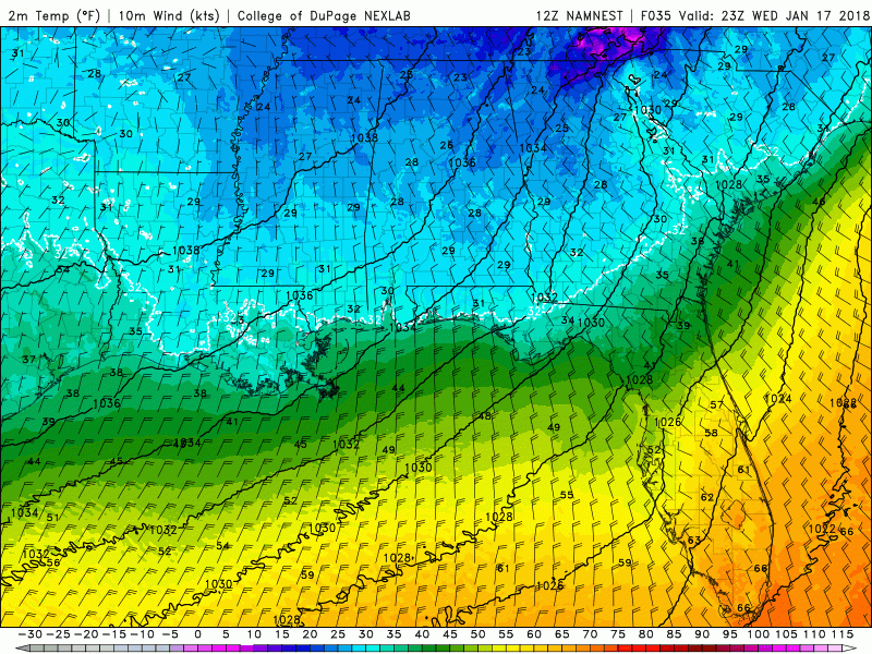
![]() by LargoFL Wed Jan 17, 2018 7:10 am
by LargoFL Wed Jan 17, 2018 7:10 am
National Weather Service Tampa Bay Area - Ruskin FL
358 AM EST Wed Jan 17 2018
...Freezing temperatures likely tonight through early Thursday...
.A strong cold front will move through the area, allowing an
Arctic airmass to invade the region. This will set the stage for
another freeze and very low wind chills tonight into Thursday.
FLZ052-056-057-061-148-149-151-251-255-260-172100-
/O.CON.KTBW.FZ.A.0007.180118T0400Z-180118T1400Z/
Polk-Hardee-Highlands-DeSoto-Coastal Hernando-Coastal Pasco-
Coastal Hillsborough-Inland Hillsborough-Inland Manatee-
Inland Sarasota-
Including the cities of Lakeland, Winter Haven, Wauchula,
Bowling Green, Zolfo Springs, Sebring, Avon Park, Placid Lakes,
Arcadia, Hernando Beach, Bayport, Port Richey, Hudson, Tampa,
Apollo Beach, Westchase, Brandon, Plant City, Sun City Center,
Parrish, Lakewood Ranch, Myakka City, and North Port
358 AM EST Wed Jan 17 2018
...FREEZE WATCH REMAINS IN EFFECT FROM THIS EVENING THROUGH
THURSDAY MORNING...
* TEMPERATURE...28 to 32 degrees
* DURATION...5 to 8 hours
* IMPACTS...Unprotected plants may not survive.
PRECAUTIONARY/PREPAREDNESS ACTIONS...
A Freeze Watch means sub-freezing temperatures are possible.
These conditions could kill crops and other sensitive vegetation.
&&
$$
LargoFL- Posts : 10724
Reputation : 130
Join date : 2017-03-05
Re: CLOSED 1-6 Florida/Alabama Blog - January Thaw!
![]() by LargoFL Wed Jan 17, 2018 7:13 am
by LargoFL Wed Jan 17, 2018 7:13 am
LargoFL- Posts : 10724
Reputation : 130
Join date : 2017-03-05
Page 3 of 10 • 1, 2, 3, 4, 5, 6, 7, 8, 9, 10 ![]()
» CLOSED FLORIDA/ALABAMA/TROPICAL BLOG
» CLOSED April - Florida/Alabama Blog
» CLOSED 4/2/17 Florida/Alabama Weather Blog
» CLOSED 5/29/17 Florida/Alabama Weather Blog
:: Florida Blog


» summer 2019 hurricane season
» April-May Florida weather and local events etc
» NASCAR 2019
» Late January through February outlook
» FLORIDA/ALABAMA AND THE HOLIDAY SEASON WEATHER
» NASCAR 2018
» CLOSED Florida/Alabama Blog - October Tropical Mischief