


Tropical Threats First Part of Sept
Page 6 of 7 •  1, 2, 3, 4, 5, 6, 7
 ![]()
Re: Tropical Threats First Part of Sept
![]() by gomexwx Thu Sep 07, 2017 10:31 am
by gomexwx Thu Sep 07, 2017 10:31 am
sangria wrote:gomexwx wrote:That shortwave is faster than predicted..I hope with tha zonal flow it dont dig much farther south..If it does stationary Katia could gain latitude and lift north and be pulled NE with that flow..
In chatting with someone this morning, I wondered why there was no forecasted effect on Katia from that shortwave.
because they are paying attention to Irma, I have been watching Katia since she was a cloud. Climatology alone dictates pay attention for this time of the year for anything in that area...

gomexwx- Posts : 641
Reputation : 63
Join date : 2012-07-16
Location : On an Acre somewhere on the gulf Coast
Re: Tropical Threats First Part of Sept
![]() by LargoFL Thu Sep 07, 2017 10:58 am
by LargoFL Thu Sep 07, 2017 10:58 am
A Storm Surge Watch is in effect for...
* Jupiter Inlet southward around the Florida peninsula to Bonita
Beach
* Florida Keys
A Hurricane Warning is in effect for...
* Dominican Republic from Cabo Engano to the northern border with
Haiti
* Haiti from the northern border with the Dominican Republic to Le
Mole St. Nicholas
* Southeastern Bahamas and the Turks and Caicos Islands
* Central Bahamas
* Northwestern Bahamas
A Hurricane Watch is in effect for...
* Jupiter Inlet southward around the Florida peninsula to Bonita
Beach
* Florida Keys
* Lake Okeechobee
* Florida Bay
* Cuba from Matanzas province eastward to Guantanamo province

LargoFL- Posts : 10724
Reputation : 130
Join date : 2017-03-05
Re: Tropical Threats First Part of Sept
![]() by LargoFL Thu Sep 07, 2017 11:07 am
by LargoFL Thu Sep 07, 2017 11:07 am

LargoFL- Posts : 10724
Reputation : 130
Join date : 2017-03-05
Re: Tropical Threats First Part of Sept
![]() by LargoFL Thu Sep 07, 2017 11:08 am
by LargoFL Thu Sep 07, 2017 11:08 am
LargoFL- Posts : 10724
Reputation : 130
Join date : 2017-03-05
Re: Tropical Threats First Part of Sept
![]() by LargoFL Thu Sep 07, 2017 11:09 am
by LargoFL Thu Sep 07, 2017 11:09 am
LargoFL- Posts : 10724
Reputation : 130
Join date : 2017-03-05
Re: Tropical Threats First Part of Sept
![]() by LargoFL Thu Sep 07, 2017 12:02 pm
by LargoFL Thu Sep 07, 2017 12:02 pm
LargoFL- Posts : 10724
Reputation : 130
Join date : 2017-03-05
Re: Tropical Threats First Part of Sept
![]() by LargoFL Thu Sep 07, 2017 12:17 pm
by LargoFL Thu Sep 07, 2017 12:17 pm

LargoFL- Posts : 10724
Reputation : 130
Join date : 2017-03-05

LargoFL- Posts : 10724
Reputation : 130
Join date : 2017-03-05

LargoFL- Posts : 10724
Reputation : 130
Join date : 2017-03-05
Re: Tropical Threats First Part of Sept
![]() by LargoFL Thu Sep 07, 2017 12:54 pm
by LargoFL Thu Sep 07, 2017 12:54 pm
LargoFL- Posts : 10724
Reputation : 130
Join date : 2017-03-05
Re: Tropical Threats First Part of Sept
![]() by LargoFL Thu Sep 07, 2017 12:57 pm
by LargoFL Thu Sep 07, 2017 12:57 pm
LargoFL- Posts : 10724
Reputation : 130
Join date : 2017-03-05
Re: Tropical Threats First Part of Sept
![]() by StAugustineFL Thu Sep 07, 2017 1:56 pm
by StAugustineFL Thu Sep 07, 2017 1:56 pm
Bills - you are batting leadoff. I sincerely hope 1) the storm weakens by the time it approaches you, 2) it turns east, or 3) you dodge the eyewall.

StAugustineFL- Posts : 2231
Reputation : 64
Join date : 2012-07-17
Re: Tropical Threats First Part of Sept
![]() by LargoFL Thu Sep 07, 2017 2:43 pm
by LargoFL Thu Sep 07, 2017 2:43 pm
LargoFL- Posts : 10724
Reputation : 130
Join date : 2017-03-05
Re: Tropical Threats First Part of Sept
![]() by LargoFL Thu Sep 07, 2017 2:44 pm
by LargoFL Thu Sep 07, 2017 2:44 pm
LargoFL- Posts : 10724
Reputation : 130
Join date : 2017-03-05
gomexwx- Posts : 641
Reputation : 63
Join date : 2012-07-16
Location : On an Acre somewhere on the gulf Coast
Re: Tropical Threats First Part of Sept
![]() by LargoFL Thu Sep 07, 2017 2:46 pm
by LargoFL Thu Sep 07, 2017 2:46 pm
LargoFL- Posts : 10724
Reputation : 130
Join date : 2017-03-05
Re: Tropical Threats First Part of Sept
![]() by PuppyToes Thu Sep 07, 2017 3:33 pm
by PuppyToes Thu Sep 07, 2017 3:33 pm

PuppyToes- Posts : 185
Reputation : 4
Join date : 2017-03-28
Re: Tropical Threats First Part of Sept
![]() by LargoFL Thu Sep 07, 2017 4:18 pm
by LargoFL Thu Sep 07, 2017 4:18 pm
hi PT, some folks around me are doing their outside preps etc..im doing mine tomorrow if I can calm down some..glad your prepping also...those who heeded the warnings and prepared will survive this.PuppyToes wrote:Hey all. We've been busy taking outside decorations down trellises and our furniture inside the garage. I've been monitoring the site as well as latest wx info. Our nerves are frayed to say the least. Nobody around us is doing any outside preps but we are doing everything we can. Just took inside pix and now outside in a min. Lord keep us safe and in Your hands during the storm.
LargoFL- Posts : 10724
Reputation : 130
Join date : 2017-03-05
Re: Tropical Threats First Part of Sept
![]() by LargoFL Thu Sep 07, 2017 4:19 pm
by LargoFL Thu Sep 07, 2017 4:19 pm

LargoFL- Posts : 10724
Reputation : 130
Join date : 2017-03-05
Re: Tropical Threats First Part of Sept
![]() by BillsfaninSoFla Thu Sep 07, 2017 4:24 pm
by BillsfaninSoFla Thu Sep 07, 2017 4:24 pm
BillsfaninSoFla- Posts : 1966
Reputation : 52
Join date : 2017-03-05
Re: Tropical Threats First Part of Sept
![]() by PuppyToes Thu Sep 07, 2017 4:25 pm
by PuppyToes Thu Sep 07, 2017 4:25 pm
PuppyToes- Posts : 185
Reputation : 4
Join date : 2017-03-28
Re: Tropical Threats First Part of Sept
![]() by PuppyToes Thu Sep 07, 2017 4:27 pm
by PuppyToes Thu Sep 07, 2017 4:27 pm
PuppyToes- Posts : 185
Reputation : 4
Join date : 2017-03-28
Re: Tropical Threats First Part of Sept
![]() by PuppyToes Thu Sep 07, 2017 4:31 pm
by PuppyToes Thu Sep 07, 2017 4:31 pm
PuppyToes- Posts : 185
Reputation : 4
Join date : 2017-03-28
Re: Tropical Threats First Part of Sept
![]() by LargoFL Thu Sep 07, 2017 5:47 pm
by LargoFL Thu Sep 07, 2017 5:47 pm
you got the prayers Billsfan,hope you get thru this safe ok.BillsfaninSoFla wrote:Hi guys. I'm totally beyond worry at this point. Please pray for all of us.
LargoFL- Posts : 10724
Reputation : 130
Join date : 2017-03-05
Re: Tropical Threats First Part of Sept
![]() by JRnOldsmar Thu Sep 07, 2017 6:13 pm
by JRnOldsmar Thu Sep 07, 2017 6:13 pm
Where will she go? Am I wrong in thinking that best case for all is up the FL spine (other than ots, of course)? Certainly scrape Cuba a bit (no offense intended). The most possible land interaction, centered on the least population?
Random thought: Are they dumping Okeechobee?

JRnOldsmar- Posts : 828
Reputation : 48
Join date : 2017-03-05
Location : Oldsmar, FL
JRnOldsmar- Posts : 828
Reputation : 48
Join date : 2017-03-05
Location : Oldsmar, FL
Re: Tropical Threats First Part of Sept
![]() by LargoFL Fri Sep 08, 2017 5:36 am
by LargoFL Fri Sep 08, 2017 5:36 am
LargoFL- Posts : 10724
Reputation : 130
Join date : 2017-03-05
Re: Tropical Threats First Part of Sept
![]() by LargoFL Fri Sep 08, 2017 5:43 am
by LargoFL Fri Sep 08, 2017 5:43 am
LargoFL- Posts : 10724
Reputation : 130
Join date : 2017-03-05
Re: Tropical Threats First Part of Sept
![]() by LargoFL Fri Sep 08, 2017 5:44 am
by LargoFL Fri Sep 08, 2017 5:44 am
LargoFL- Posts : 10724
Reputation : 130
Join date : 2017-03-05
Re: Tropical Threats First Part of Sept
![]() by sangria Fri Sep 08, 2017 7:11 am
by sangria Fri Sep 08, 2017 7:11 am
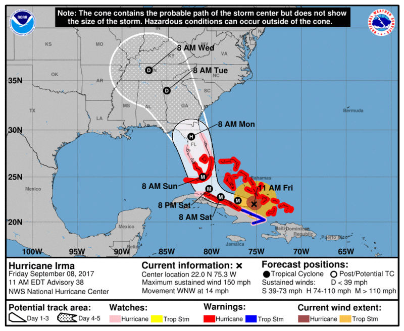
No changes to speak of with the 5am advisory. Euro still likes west and GFS still likes a bit further east. The hurricane model, the HWRF, is in line with the GFS. Until the "actual" turn occurs we can speculate all we want, but that turn is paramount to where Irma ends up tracking north.
There is also a chance that she will have some interplay with Cuba as she moves west today, and that could impact her intensity. (from our mouths to God's ears).
I hope everyone has prepared or evacuated as needed. If you are still in need of gas because you couldn't find any, there is an app called Gas Buddy that you can download to your phone (both android and iphone). This app is updating in real time with which stations have gas in your area. It is very simple to use (my neighbor showed it to me yesterday).
I'll be heading out to top off the tank this morning and dare I say it, "Run into Wally World." Yep! I have to swing by there, but only to pick up an "order and pick up in store" battery operated fan. I would have already gone, but you can't do a pick up until 8am....ugggh.
Try not to go blind watching the model runs and PLEASE don't pay attention to the hype on social media. There are way too many reliable sources to get your information from.
The latest visible loop of Irma, with another dangerous situation from Jose for the Leeward Islands behind her....

Ta Ta For Now............

sangria- Admin
- Posts : 2345
Reputation : 55
Join date : 2012-07-16
Re: Tropical Threats First Part of Sept
![]() by StAugustineFL Fri Sep 08, 2017 8:29 am
by StAugustineFL Fri Sep 08, 2017 8:29 am
StAugustineFL- Posts : 2231
Reputation : 64
Join date : 2012-07-17
Re: Tropical Threats First Part of Sept
![]() by JRnOldsmar Fri Sep 08, 2017 9:13 am
by JRnOldsmar Fri Sep 08, 2017 9:13 am
LargoFL wrote:JR will you be home thru Irma too?
JR is in Atlanta. Backup contingency for work. There's about 25 of us here, and another 10 in NJ. Just in case we lose our data center to Irma. I left early enough on Wednesday to miss most of the I-75 parking lot -- Still made it in about 7 hours.
I wish I was home.
JRnOldsmar- Posts : 828
Reputation : 48
Join date : 2017-03-05
Location : Oldsmar, FL
Re: Tropical Threats First Part of Sept
![]() by LargoFL Fri Sep 08, 2017 10:10 am
by LargoFL Fri Sep 08, 2017 10:10 am
ok JR glad your in a safe place....local mets on TV are predicting..so far anyway..we may be on the west side of a cat-2 hurricane,possible 70-90 mph winds with higher gusts...still early yet, things could change..hope we get thru this in one piece..JRnOldsmar wrote:LargoFL wrote:JR will you be home thru Irma too?
JR is in Atlanta. Backup contingency for work. There's about 25 of us here, and another 10 in NJ. Just in case we lose our data center to Irma. I left early enough on Wednesday to miss most of the I-75 parking lot -- Still made it in about 7 hours.
I wish I was home.
LargoFL- Posts : 10724
Reputation : 130
Join date : 2017-03-05
Re: Tropical Threats First Part of Sept
![]() by JRnOldsmar Fri Sep 08, 2017 11:23 am
by JRnOldsmar Fri Sep 08, 2017 11:23 am
WATCHES AND WARNINGS
--------------------
CHANGES WITH THIS ADVISORY:
The Storm Surge Warning has been extended from Jupiter Inlet
northward to Sebastian Inlet and from Bonita Beach northward to
Venice.
A Storm Surge Watch has been issued from north of Sebastian Inlet to
Ponce Inlet.
The Hurricane Watch has been extended northward along the east
coast of Florida to the Flagler/Volusia County Line, and along the
west coast of Florida to Anclote River.
JRnOldsmar- Posts : 828
Reputation : 48
Join date : 2017-03-05
Location : Oldsmar, FL
Re: Tropical Threats First Part of Sept
![]() by LargoFL Fri Sep 08, 2017 11:39 am
by LargoFL Fri Sep 08, 2017 11:39 am
LargoFL- Posts : 10724
Reputation : 130
Join date : 2017-03-05
Re: Tropical Threats First Part of Sept
![]() by LargoFL Fri Sep 08, 2017 11:46 am
by LargoFL Fri Sep 08, 2017 11:46 am
LargoFL- Posts : 10724
Reputation : 130
Join date : 2017-03-05
Re: Tropical Threats First Part of Sept
![]() by StAugustineFL Fri Sep 08, 2017 12:20 pm
by StAugustineFL Fri Sep 08, 2017 12:20 pm
LargoFL wrote:well some good news ..so far they think Irma will be down to a cat-1 hurricane up in central florida,but stay alert anyway, this storm loves to fool these experts huh
I'm keeping an eye on that. Current forecast from the NHC has 145mph at landfall in south FL then down to 75mph 24 hours later. Seems too quick a drop in intensity but we shall see. Now, that 75mph marker was a little to my WSW. I would think it'd still be packing 90-100mph when passing Tampa latitude.
StAugustineFL- Posts : 2231
Reputation : 64
Join date : 2012-07-17
Re: Tropical Threats First Part of Sept
![]() by LargoFL Fri Sep 08, 2017 2:50 pm
by LargoFL Fri Sep 08, 2017 2:50 pm

LargoFL- Posts : 10724
Reputation : 130
Join date : 2017-03-05
Re: Tropical Threats First Part of Sept
![]() by LargoFL Fri Sep 08, 2017 2:52 pm
by LargoFL Fri Sep 08, 2017 2:52 pm
LargoFL- Posts : 10724
Reputation : 130
Join date : 2017-03-05
Re: Tropical Threats First Part of Sept
![]() by LargoFL Fri Sep 08, 2017 6:13 pm
by LargoFL Fri Sep 08, 2017 6:13 pm

LargoFL- Posts : 10724
Reputation : 130
Join date : 2017-03-05
Re: Tropical Threats First Part of Sept
![]() by LargoFL Fri Sep 08, 2017 6:14 pm
by LargoFL Fri Sep 08, 2017 6:14 pm
LargoFL- Posts : 10724
Reputation : 130
Join date : 2017-03-05
Re: Tropical Threats First Part of Sept
![]() by LargoFL Fri Sep 08, 2017 7:24 pm
by LargoFL Fri Sep 08, 2017 7:24 pm
LargoFL- Posts : 10724
Reputation : 130
Join date : 2017-03-05
Re: Tropical Threats First Part of Sept
![]() by LargoFL Sat Sep 09, 2017 6:56 am
by LargoFL Sat Sep 09, 2017 6:56 am
LargoFL- Posts : 10724
Reputation : 130
Join date : 2017-03-05

LargoFL- Posts : 10724
Reputation : 130
Join date : 2017-03-05
LargoFL- Posts : 10724
Reputation : 130
Join date : 2017-03-05
Re: Tropical Threats First Part of Sept
![]() by BillsfaninSoFla Sat Sep 09, 2017 2:48 pm
by BillsfaninSoFla Sat Sep 09, 2017 2:48 pm
BillsfaninSoFla- Posts : 1966
Reputation : 52
Join date : 2017-03-05
Re: Tropical Threats First Part of Sept
![]() by PuppyToes Sat Sep 09, 2017 3:20 pm
by PuppyToes Sat Sep 09, 2017 3:20 pm
PuppyToes- Posts : 185
Reputation : 4
Join date : 2017-03-28
Re: Tropical Threats First Part of Sept
![]() by sangria Sat Sep 09, 2017 4:30 pm
by sangria Sat Sep 09, 2017 4:30 pm
Let us know how you fare by posting when you can..... prayers for everyone and
 on Irma!!
sangria- Admin
- Posts : 2345
Reputation : 55
Join date : 2012-07-16
Re: Tropical Threats First Part of Sept
![]() by StAugustineFL Sat Sep 09, 2017 9:34 pm
by StAugustineFL Sat Sep 09, 2017 9:34 pm
Key West:

Miami:

Tampa:

Jacksonville:

StAugustineFL- Posts : 2231
Reputation : 64
Join date : 2012-07-17
Re: Tropical Threats First Part of Sept
![]() by StAugustineFL Sat Sep 09, 2017 9:42 pm
by StAugustineFL Sat Sep 09, 2017 9:42 pm
StAugustineFL- Posts : 2231
Reputation : 64
Join date : 2012-07-17
Page 6 of 7 • 1, 2, 3, 4, 5, 6, 7 ![]()
» WINTER 2012 - 2013; Part Three
» Tropical Teaser?
» Tropical Storm Erika
» The Tropical Wave Train


» summer 2019 hurricane season
» April-May Florida weather and local events etc
» NASCAR 2019
» Late January through February outlook
» FLORIDA/ALABAMA AND THE HOLIDAY SEASON WEATHER
» NASCAR 2018
» CLOSED Florida/Alabama Blog - October Tropical Mischief