


CLOSED FLORIDA/ALABAMA/TROPICAL BLOG
:: Florida Blog
Page 4 of 13 •  1, 2, 3, 4, 5 ... 11, 12, 13
 ![]()
Re: CLOSED FLORIDA/ALABAMA/TROPICAL BLOG
![]() by sangria Wed Aug 30, 2017 6:29 pm
by sangria Wed Aug 30, 2017 6:29 pm
BillsfaninSoFla wrote:JR gas prices are up already (at least down here) I paid $2.49/gallon today.
How much of a jump was that for you Billsfan? I don't keep up with the fluctuations too much since I office out of my home. I don't use a lot of gas.

sangria- Admin
- Posts : 2345
Reputation : 55
Join date : 2012-07-16
Re: CLOSED FLORIDA/ALABAMA/TROPICAL BLOG
![]() by StAugustineFL Wed Aug 30, 2017 6:41 pm
by StAugustineFL Wed Aug 30, 2017 6:41 pm
Harvey was around 938MB at landfall I believe. How about the GFS down to 908MB with Irma?. Run is still in the process of finishing up.


StAugustineFL- Posts : 2231
Reputation : 64
Join date : 2012-07-17
Re: CLOSED FLORIDA/ALABAMA/TROPICAL BLOG
![]() by StAugustineFL Wed Aug 30, 2017 6:44 pm
by StAugustineFL Wed Aug 30, 2017 6:44 pm
StAugustineFL- Posts : 2231
Reputation : 64
Join date : 2012-07-17
Re: CLOSED FLORIDA/ALABAMA/TROPICAL BLOG
![]() by BillsfaninSoFla Wed Aug 30, 2017 7:23 pm
by BillsfaninSoFla Wed Aug 30, 2017 7:23 pm
BillsfaninSoFla- Posts : 1966
Reputation : 52
Join date : 2017-03-05
Re: CLOSED FLORIDA/ALABAMA/TROPICAL BLOG
![]() by BillsfaninSoFla Wed Aug 30, 2017 7:27 pm
by BillsfaninSoFla Wed Aug 30, 2017 7:27 pm
BillsfaninSoFla- Posts : 1966
Reputation : 52
Join date : 2017-03-05
Re: CLOSED FLORIDA/ALABAMA/TROPICAL BLOG
![]() by JRnOldsmar Wed Aug 30, 2017 7:40 pm
by JRnOldsmar Wed Aug 30, 2017 7:40 pm
BillsfaninSoFla wrote:JR gas prices are up already (at least down here) I paid $2.49/gallon today.
I topped off at 2.29 late last week, and it just dropped from 2.24 to 2.19 today. I'll be topping off again tomorrow. Road trip coming at 17 miles per gallon.

JRnOldsmar- Posts : 828
Reputation : 48
Join date : 2017-03-05
Location : Oldsmar, FL
Re: CLOSED FLORIDA/ALABAMA/TROPICAL BLOG
![]() by JRnOldsmar Wed Aug 30, 2017 7:51 pm
by JRnOldsmar Wed Aug 30, 2017 7:51 pm
JRnOldsmar- Posts : 828
Reputation : 48
Join date : 2017-03-05
Location : Oldsmar, FL
Re: CLOSED FLORIDA/ALABAMA/TROPICAL BLOG
![]() by sangria Wed Aug 30, 2017 8:08 pm
by sangria Wed Aug 30, 2017 8:08 pm
sangria- Admin
- Posts : 2345
Reputation : 55
Join date : 2012-07-16
Re: CLOSED FLORIDA/ALABAMA/TROPICAL BLOG
![]() by LargoFL Thu Aug 31, 2017 4:25 am
by LargoFL Thu Aug 31, 2017 4:25 am


LargoFL- Posts : 10724
Reputation : 130
Join date : 2017-03-05
Re: CLOSED FLORIDA/ALABAMA/TROPICAL BLOG
![]() by LargoFL Thu Aug 31, 2017 4:27 am
by LargoFL Thu Aug 31, 2017 4:27 am
LargoFL- Posts : 10724
Reputation : 130
Join date : 2017-03-05
Re: CLOSED FLORIDA/ALABAMA/TROPICAL BLOG
![]() by LargoFL Thu Aug 31, 2017 4:29 am
by LargoFL Thu Aug 31, 2017 4:29 am
LargoFL- Posts : 10724
Reputation : 130
Join date : 2017-03-05
Re: CLOSED FLORIDA/ALABAMA/TROPICAL BLOG
![]() by LargoFL Thu Aug 31, 2017 4:37 am
by LargoFL Thu Aug 31, 2017 4:37 am
LargoFL- Posts : 10724
Reputation : 130
Join date : 2017-03-05

LargoFL- Posts : 10724
Reputation : 130
Join date : 2017-03-05
Re: CLOSED FLORIDA/ALABAMA/TROPICAL BLOG
![]() by LargoFL Thu Aug 31, 2017 4:57 am
by LargoFL Thu Aug 31, 2017 4:57 am
Tropical Storm Irma Advisory Number 4
NWS National Hurricane Center Miami FL AL112017
500 AM AST Thu Aug 31 2017
...IRMA CLOSE TO HURRICANE STRENGTH...
SUMMARY OF 500 AM AST...0900 UTC...INFORMATION
----------------------------------------------
LOCATION...16.5N 32.9W
ABOUT 590 MI...950 KM W OF THE CABO VERDE ISLANDS
MAXIMUM SUSTAINED WINDS...70 MPH...110 KM/H
PRESENT MOVEMENT...W OR 280 DEGREES AT 12 MPH...19 KM/H
MINIMUM CENTRAL PRESSURE...997 MB...29.44 INCHES
WATCHES AND WARNINGS
--------------------
There are no coastal watches or warnings in effect.
DISCUSSION AND 48-HOUR OUTLOOK
------------------------------
At 500 AM AST (0900 UTC), the center of Tropical Storm Irma was
located near latitude 16.5 North, longitude 32.9 West. Irma is
moving toward the west near 12 mph (19 km/h). A west-northwestward
motion is expected today and tonight, followed by a generally
westward motion on Friday.
Maximum sustained winds have increased to near 70 mph (110 km/h)
with higher gusts. Additional strengthening is forecast, and
Irma is likely to become a hurricane later today.
Tropical-storm-force winds extend outward up to 60 miles (95 km)
from the center.
The estimated minimum central pressure is 997 mb (29.44 inches).
HAZARDS AFFECTING LAND
----------------------
None
NEXT ADVISORY
-------------
Next complete advisory at 1100 AM AST.
$$
Forecaster Pasch
LargoFL- Posts : 10724
Reputation : 130
Join date : 2017-03-05
Re: CLOSED FLORIDA/ALABAMA/TROPICAL BLOG
![]() by severstorm Thu Aug 31, 2017 6:35 am
by severstorm Thu Aug 31, 2017 6:35 am
Hi, Went by gas station this morning was 2.22 now 2.40 Z-hillsLargoFL wrote:yes gas prices went up some here too, last time I gassed up it was $2.26.
severstorm- Posts : 331
Reputation : 14
Join date : 2017-03-14
Age : 61
Location : Zephyrhills
Re: CLOSED FLORIDA/ALABAMA/TROPICAL BLOG
![]() by severstorm Thu Aug 31, 2017 6:52 am
by severstorm Thu Aug 31, 2017 6:52 am
LargoFL wrote:i'll try to keep up on the models for Irma as best I can but..i'll keep saying this...we cannot believe any of them, track wise..its way too early yet and things can change run to run, let alone day to day huh..
Morning all, The next storm Irma is worth keeping an eye on. This one bothers me. JMO!!
Have a great day!!
John Z-hills
severstorm- Posts : 331
Reputation : 14
Join date : 2017-03-14
Age : 61
Location : Zephyrhills
Re: CLOSED FLORIDA/ALABAMA/TROPICAL BLOG
![]() by LargoFL Thu Aug 31, 2017 7:08 am
by LargoFL Thu Aug 31, 2017 7:08 am
good morning John..yes all eyes on Irmaseverstorm wrote:LargoFL wrote:i'll try to keep up on the models for Irma as best I can but..i'll keep saying this...we cannot believe any of them, track wise..its way too early yet and things can change run to run, let alone day to day huh..
Morning all, The next storm Irma is worth keeping an eye on. This one bothers me. JMO!!
Have a great day!!
John Z-hills
LargoFL- Posts : 10724
Reputation : 130
Join date : 2017-03-05
Re: CLOSED FLORIDA/ALABAMA/TROPICAL BLOG
![]() by LargoFL Thu Aug 31, 2017 7:08 am
by LargoFL Thu Aug 31, 2017 7:08 am
This Hazardous Weather Outlook is for West Central And Southwest
Florida.
.DAY ONE...Today and Tonight.
...THUNDERSTORM IMPACT...
Scattered thunderstorms are expected today, with the higher rain
chances across interior portions of the peninsula. Gusty winds,
frequent lightning, and torrential rains will accompany any
stronger storms.
...RIVER FLOOD IMPACT...
Several area rivers will remain in flood stage over the next few
days. Additional rainfall may worsen or prolong the existing
flooding.
.DAYS TWO THROUGH SEVEN...Friday through Wednesday.
...THUNDERSTORM IMPACT...
At least scattered thunderstorms will be possible each day, with
the higher rain chances expected over the weekend. Gusty winds,
frequent lightning, and torrential rains will accompany any
stronger storms.
...RIVER FLOOD IMPACT...
Several area rivers will remain in flood stage over the next few
days. Additional rainfall may worsen or prolong the existing
flooding.
.SPOTTER INFORMATION STATEMENT...
Spotter activation will not be needed today.
$$
LargoFL- Posts : 10724
Reputation : 130
Join date : 2017-03-05
Re: CLOSED FLORIDA/ALABAMA/TROPICAL BLOG
![]() by LargoFL Thu Aug 31, 2017 8:10 am
by LargoFL Thu Aug 31, 2017 8:10 am

LargoFL- Posts : 10724
Reputation : 130
Join date : 2017-03-05
Re: CLOSED FLORIDA/ALABAMA/TROPICAL BLOG
![]() by StAugustineFL Thu Aug 31, 2017 8:30 am
by StAugustineFL Thu Aug 31, 2017 8:30 am
StAugustineFL- Posts : 2231
Reputation : 64
Join date : 2012-07-17
Re: CLOSED FLORIDA/ALABAMA/TROPICAL BLOG
![]() by JRnOldsmar Thu Aug 31, 2017 8:39 am
by JRnOldsmar Thu Aug 31, 2017 8:39 am
JRnOldsmar- Posts : 828
Reputation : 48
Join date : 2017-03-05
Location : Oldsmar, FL
Re: CLOSED FLORIDA/ALABAMA/TROPICAL BLOG
![]() by LargoFL Thu Aug 31, 2017 8:56 am
by LargoFL Thu Aug 31, 2017 8:56 am
LargoFL- Posts : 10724
Reputation : 130
Join date : 2017-03-05
Re: CLOSED FLORIDA/ALABAMA/TROPICAL BLOG
![]() by LargoFL Thu Aug 31, 2017 8:57 am
by LargoFL Thu Aug 31, 2017 8:57 am
LargoFL- Posts : 10724
Reputation : 130
Join date : 2017-03-05
LargoFL- Posts : 10724
Reputation : 130
Join date : 2017-03-05
Re: CLOSED FLORIDA/ALABAMA/TROPICAL BLOG
![]() by LargoFL Thu Aug 31, 2017 9:17 am
by LargoFL Thu Aug 31, 2017 9:17 am
LargoFL- Posts : 10724
Reputation : 130
Join date : 2017-03-05
Re: CLOSED FLORIDA/ALABAMA/TROPICAL BLOG
![]() by BillsfaninSoFla Thu Aug 31, 2017 9:28 am
by BillsfaninSoFla Thu Aug 31, 2017 9:28 am
I don't like Irma either. Go away Irma.
BillsfaninSoFla- Posts : 1966
Reputation : 52
Join date : 2017-03-05
Re: CLOSED FLORIDA/ALABAMA/TROPICAL BLOG
![]() by LargoFL Thu Aug 31, 2017 10:54 am
by LargoFL Thu Aug 31, 2017 10:54 am
good morning Billsfan,yes IRMA go away!!BillsfaninSoFla wrote:Good morning. Gas is 2.59 this morning!
I don't like Irma either. Go away Irma.
LargoFL- Posts : 10724
Reputation : 130
Join date : 2017-03-05
Re: CLOSED FLORIDA/ALABAMA/TROPICAL BLOG
![]() by StAugustineFL Thu Aug 31, 2017 11:51 am
by StAugustineFL Thu Aug 31, 2017 11:51 am

StAugustineFL- Posts : 2231
Reputation : 64
Join date : 2012-07-17
Re: CLOSED FLORIDA/ALABAMA/TROPICAL BLOG
![]() by StAugustineFL Thu Aug 31, 2017 11:55 am
by StAugustineFL Thu Aug 31, 2017 11:55 am
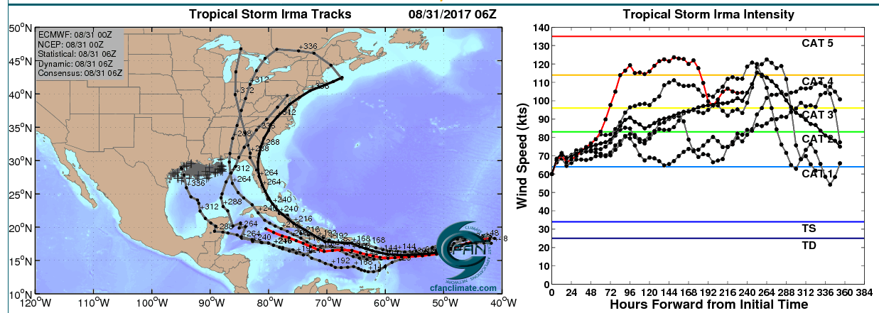
https://pbs.twimg.com/media/DIjz_8LUIAAqx4u.jpg
Those intensity maps are going to go up. They were initialized when Irma was 60mph. The most aggressive model didn't have her up to 100mph until 72 more hours.
StAugustineFL- Posts : 2231
Reputation : 64
Join date : 2012-07-17
Re: CLOSED FLORIDA/ALABAMA/TROPICAL BLOG
![]() by JRnOldsmar Thu Aug 31, 2017 12:01 pm
by JRnOldsmar Thu Aug 31, 2017 12:01 pm

This is just keeps getting better and better.
JRnOldsmar- Posts : 828
Reputation : 48
Join date : 2017-03-05
Location : Oldsmar, FL
Re: CLOSED FLORIDA/ALABAMA/TROPICAL BLOG
![]() by StAugustineFL Thu Aug 31, 2017 12:06 pm
by StAugustineFL Thu Aug 31, 2017 12:06 pm
StAugustineFL- Posts : 2231
Reputation : 64
Join date : 2012-07-17
Re: CLOSED FLORIDA/ALABAMA/TROPICAL BLOG
![]() by LargoFL Thu Aug 31, 2017 12:38 pm
by LargoFL Thu Aug 31, 2017 12:38 pm

LargoFL- Posts : 10724
Reputation : 130
Join date : 2017-03-05
Re: CLOSED FLORIDA/ALABAMA/TROPICAL BLOG
![]() by LargoFL Thu Aug 31, 2017 12:43 pm
by LargoFL Thu Aug 31, 2017 12:43 pm
LargoFL- Posts : 10724
Reputation : 130
Join date : 2017-03-05
Re: CLOSED FLORIDA/ALABAMA/TROPICAL BLOG
![]() by StAugustineFL Thu Aug 31, 2017 12:46 pm
by StAugustineFL Thu Aug 31, 2017 12:46 pm
NWS National Hurricane Center Miami FL AL112017
1100 AM AST Thu Aug 31 2017
Satellite images indicate that Irma is rapidly intensifying.
Very deep convection has formed in the central dense overcast,
which is now displaying a small and clearing eye. Dvorak estimates
were up to 77 kt at 1200 UTC, and since the cloud pattern continues
to quickly become more organized, the initial wind speed is set to
85 kt.
Irma has moved somewhat south of and slower than all of the model
guidance since yesterday. Consequently, it stayed longer over the
warmer ocean temperatures away from the drier air to the north,
possibly allowing the rapid strengthening. Irma should move over
cooler waters tomorrow with some increase in mid-level dry air, so
hopefully the hurricane's intensity will level off by then. In a
few days, the hurricane will be moving over warmer waters with light
shear shown by all of the model guidance. This should promote
further strengthening of Irma, and the NHC forecast shows an
extremely dangerous category 4 hurricane next week, similar to the
solutions provided by the HWRF and the ECMWF models. The intensity
forecast is raised considerably from the previous one due to initial
trends, and is on the high end of the guidance at long range.
The hurricane has turned west-northwestward at about 9 kt. This
motion should continue for the next day or so before a ridge builds
over the central Atlantic Ocean. This ridge should force Irma to
turn westward by the weekend, and west-southwestward early next
week. Guidance continues to trend southward, following the trend of
the ECMWF model starting yesterday. Given the strength of the ridge
and depth of the tropical cyclone, there are no obvious reasons to
discount the anomalous west-southwestward motion seen in most of the
guidance. Little change is made to the track forecast in short
range, but the track is shifted southward and westward at long
range, though not as far southwest as the overnight ECMWF and ECMWF
ensemble models.
FORECAST POSITIONS AND MAX WINDS
INIT 31/1500Z 16.9N 33.8W 85 KT 100 MPH
12H 01/0000Z 17.5N 35.2W 100 KT 115 MPH
24H 01/1200Z 18.0N 37.1W 105 KT 120 MPH
36H 02/0000Z 18.2N 39.2W 105 KT 120 MPH
48H 02/1200Z 18.1N 41.6W 105 KT 120 MPH
72H 03/1200Z 17.0N 46.5W 110 KT 125 MPH
96H 04/1200Z 16.0N 51.0W 110 KT 125 MPH
120H 05/1200Z 16.0N 55.5W 115 KT 130 MPH
$$
Forecaster Blake
StAugustineFL- Posts : 2231
Reputation : 64
Join date : 2012-07-17
Re: CLOSED FLORIDA/ALABAMA/TROPICAL BLOG
![]() by LargoFL Thu Aug 31, 2017 12:49 pm
by LargoFL Thu Aug 31, 2017 12:49 pm
LargoFL- Posts : 10724
Reputation : 130
Join date : 2017-03-05
Re: CLOSED FLORIDA/ALABAMA/TROPICAL BLOG
![]() by BillsfaninSoFla Thu Aug 31, 2017 12:58 pm
by BillsfaninSoFla Thu Aug 31, 2017 12:58 pm
LargoFL wrote:Attention Blog.....Notice what is BEHIND IRMA.......................................
The noon time guy on TWC said it absolutely will NOT take a northerly turn. He said "do not get your hopes up that it will take a more northerly track" I sure the heck hope he is wrong.
BillsfaninSoFla- Posts : 1966
Reputation : 52
Join date : 2017-03-05
Re: CLOSED FLORIDA/ALABAMA/TROPICAL BLOG
![]() by JRnOldsmar Thu Aug 31, 2017 1:14 pm
by JRnOldsmar Thu Aug 31, 2017 1:14 pm
JRnOldsmar- Posts : 828
Reputation : 48
Join date : 2017-03-05
Location : Oldsmar, FL
Re: CLOSED FLORIDA/ALABAMA/TROPICAL BLOG
![]() by LargoFL Thu Aug 31, 2017 1:18 pm
by LargoFL Thu Aug 31, 2017 1:18 pm
LargoFL- Posts : 10724
Reputation : 130
Join date : 2017-03-05
Re: CLOSED FLORIDA/ALABAMA/TROPICAL BLOG
![]() by LargoFL Thu Aug 31, 2017 1:25 pm
by LargoFL Thu Aug 31, 2017 1:25 pm
LargoFL- Posts : 10724
Reputation : 130
Join date : 2017-03-05
Re: CLOSED FLORIDA/ALABAMA/TROPICAL BLOG
![]() by LargoFL Thu Aug 31, 2017 1:28 pm
by LargoFL Thu Aug 31, 2017 1:28 pm
LargoFL- Posts : 10724
Reputation : 130
Join date : 2017-03-05
Re: CLOSED FLORIDA/ALABAMA/TROPICAL BLOG
![]() by LargoFL Thu Aug 31, 2017 1:41 pm
by LargoFL Thu Aug 31, 2017 1:41 pm
...SCATTERED THUNDERSTORMS OVER THE INTERIOR AND GULF COAST...
...HEAT INDEX VALUES FROM 105 TO 109 MOST AREAS...
This hazardous weather outlook is for South Florida.
.DAY ONE...TODAY AND TONIGHT
Thunderstorms: Thunderstorms are possible, mainly this afternoon,
over interior and western sections of South Florida. Lightning will
be the primary threat, although a few thunderstorms may produce
locally heavy rainfall leading to street flooding.
Flooding: Thunderstorms may produce locally heavy rainfall this
afternoon, and could potentially cause street flooding, mainly in the
Naples area.
Temperatures: Heat indices will exceed 105 degrees this afternoon over
much of South Florida, esepcailly in interior Palm Beach and Collier
counties.
.DAYS TWO THROUGH SEVEN...FRIDAY THROUGH WEDNESDAY
Thunderstorms are likely Friday and Saturday, mainly during the
afternoons over interior South Florida. Lightning strikes are the
primary threat. A chance of thunderstorms will then continue through
early next week.
Heat index values are expected to exceed 105 degrees over portions of
South Florida Friday and Saturday.
A long period swell arriving along east coast beaches from Friday
through this weekend will increase the rip current risk to at least
a moderate impact during this time frame.
.SPOTTER INFORMATION STATEMENT...
Spotter activation is not anticipated at this time.
For more information...visit the National Weather Service in
Miami website at www.weather.gov/miami.
$$
LargoFL- Posts : 10724
Reputation : 130
Join date : 2017-03-05
Re: CLOSED FLORIDA/ALABAMA/TROPICAL BLOG
![]() by LargoFL Thu Aug 31, 2017 1:45 pm
by LargoFL Thu Aug 31, 2017 1:45 pm

LargoFL- Posts : 10724
Reputation : 130
Join date : 2017-03-05
Re: CLOSED FLORIDA/ALABAMA/TROPICAL BLOG
![]() by sangria Thu Aug 31, 2017 2:15 pm
by sangria Thu Aug 31, 2017 2:15 pm
I agree JR, this weekend is a good time to do a little re-stocking. Damn that girl!
sangria- Admin
- Posts : 2345
Reputation : 55
Join date : 2012-07-16
Re: CLOSED FLORIDA/ALABAMA/TROPICAL BLOG
![]() by StAugustineFL Thu Aug 31, 2017 2:20 pm
by StAugustineFL Thu Aug 31, 2017 2:20 pm
LargoFL wrote:when this IRMA does come close to us I'm wondering just how far away from the center these destructive 120-130mph winds would be..if it went up the middle of florida..would both coasts get those winds too?..so much I need to learn lol
No guarantee it comes close to us. It'll be 5 more days before approaching the Leeward Islands 1500+ miles away. As far as winds, the strongest are in the eyewall. How strong they are beyond depends on the size/structure of the storm at point XYZ. Could be a hurricane 150 miles away bringing you 90mph wind gusts or 40mph wind gusts. Then there's the storm surge impacts for coastal areas based on storm position and wind direction.
StAugustineFL- Posts : 2231
Reputation : 64
Join date : 2012-07-17
Re: CLOSED FLORIDA/ALABAMA/TROPICAL BLOG
![]() by LargoFL Thu Aug 31, 2017 2:22 pm
by LargoFL Thu Aug 31, 2017 2:22 pm
boy I'm with you ON THAT..THIS IS one time I'm hoping the GFS model wins..take her Northward..please.BillsfaninSoFla wrote:LargoFL wrote:Attention Blog.....Notice what is BEHIND IRMA.......................................
The noon time guy on TWC said it absolutely will NOT take a northerly turn. He said "do not get your hopes up that it will take a more northerly track" I sure the heck hope he is wrong.
LargoFL- Posts : 10724
Reputation : 130
Join date : 2017-03-05
Re: CLOSED FLORIDA/ALABAMA/TROPICAL BLOG
![]() by LargoFL Thu Aug 31, 2017 2:32 pm
by LargoFL Thu Aug 31, 2017 2:32 pm
Updated: 3 hrs 43 mins ago
BULLETIN
Hurricane Irma Advisory Number 5
NWS National Hurricane Center Miami FL AL112017
1100 AM AST Thu Aug 31 2017
... HURRICANE IRMA RAPIDLY INTENSIFYING OVER THE EASTERN ATLANTIC...
SUMMARY OF 1100 AM AST... 1500 UTC... INFORMATION
-----------------------------------------------
LOCATION... 16.9N 33.8W ABOUT 650 MI... 1050 KM W OF THE CABO VERDE ISLANDS ABOUT 1845 MI... 2975 KM E OF THE LEEWARD ISLANDS MAXIMUM SUSTAINED WINDS... 100 MPH... 155 KM/H PRESENT MOVEMENT... WNW OR 290 DEGREES AT 10 MPH... 17 KM/H MINIMUM CENTRAL PRESSURE... 979 MB... 28.91 INCHES
WATCHES AND WARNINGS
--------------------
THERE ARE NO COASTAL WATCHES OR WARNINGS IN EFFECT.
DISCUSSION AND 48-HOUR OUTLOOK
------------------------------
AT 1100 AM AST (1500 UTC), THE CENTER OF HURRICANE IRMA WAS LOCATED NEAR LATITUDE 16.9 NORTH, LONGITUDE 33.8 WEST. IRMA IS MOVING TOWARD THE WEST-NORTHWEST NEAR 10 MPH (17 KM/H). THIS GENERAL MOTION IS FORECAST THROUGH EARLY FRIDAY, FOLLOWED BY A GENERALLY WESTWARD MOTION ON SATURDAY.
MAXIMUM SUSTAINED WINDS HAVE INCREASED TO NEAR 100 MPH (155 KM/H) WITH HIGHER GUSTS. IRMA IS FORECAST TO BECOME A MAJOR HURRICANE BY TONIGHT AND IS EXPECTED TO BE AN EXTREMELY DANGEROUS HURRICANE FOR THE NEXT SEVERAL DAYS.
HURRICANE-FORCE WINDS EXTEND OUTWARD UP TO 15 MILES (30 KM) FROM THE CENTER AND TROPICAL-STORM-FORCE WINDS EXTEND OUTWARD UP TO 80 MILES (130 KM).
THE ESTIMATED MINIMUM CENTRAL PRESSURE IS 979 MB (28.91 INCHES).
HAZARDS AFFECTING LAND
----------------------
NONE
NEXT ADVISORY
-------------
NEXT COMPLETE ADVISORY AT 500 PM AST.
$$ FORECASTER BLAKE
LargoFL- Posts : 10724
Reputation : 130
Join date : 2017-03-05
Re: CLOSED FLORIDA/ALABAMA/TROPICAL BLOG
![]() by JRnOldsmar Thu Aug 31, 2017 2:44 pm
by JRnOldsmar Thu Aug 31, 2017 2:44 pm
JRnOldsmar- Posts : 828
Reputation : 48
Join date : 2017-03-05
Location : Oldsmar, FL
Re: CLOSED FLORIDA/ALABAMA/TROPICAL BLOG
![]() by LargoFL Thu Aug 31, 2017 2:44 pm
by LargoFL Thu Aug 31, 2017 2:44 pm

LargoFL- Posts : 10724
Reputation : 130
Join date : 2017-03-05
Re: CLOSED FLORIDA/ALABAMA/TROPICAL BLOG
![]() by LargoFL Thu Aug 31, 2017 2:52 pm
by LargoFL Thu Aug 31, 2017 2:52 pm

LargoFL- Posts : 10724
Reputation : 130
Join date : 2017-03-05
Re: CLOSED FLORIDA/ALABAMA/TROPICAL BLOG
![]() by PuppyToes Thu Aug 31, 2017 2:58 pm
by PuppyToes Thu Aug 31, 2017 2:58 pm

PuppyToes- Posts : 185
Reputation : 4
Join date : 2017-03-28
Page 4 of 13 • 1, 2, 3, 4, 5 ... 11, 12, 13 ![]()
» CLOSED 9-17-17 FLORIDA/ALABAMA BLOG
» CLOSED April - Florida/Alabama Blog
» CLOSED 4/2/17 Florida/Alabama Weather Blog
» CLOSED 5/29/17 Florida/Alabama Weather Blog
:: Florida Blog


» summer 2019 hurricane season
» April-May Florida weather and local events etc
» NASCAR 2019
» Late January through February outlook
» FLORIDA/ALABAMA AND THE HOLIDAY SEASON WEATHER
» NASCAR 2018
» CLOSED Florida/Alabama Blog - October Tropical Mischief