Latest topics
Florida Blog

Southeast Radar Loop

Kamala Severe Warnings

Warnings
WPC 5 Day Precip

Most Viewed Topics
Search
Leslie, Michael, and the Ghost of Isaac.
4 posters
Page 1 of 1

Leslie, Michael, and the Ghost of Isaac.
![]() by emcf30 Wed Sep 05, 2012 7:24 am
by emcf30 Wed Sep 05, 2012 7:24 am
LESLIE
Leslie continues to churn over the Atlantic slowly heading towards Bermuda.
After being decoupled for several days yesterday Leslie finally started to put some clothes on and was looking much better.


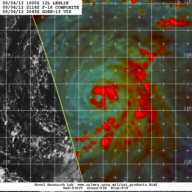

Although Leslie was looking much better she did not manage to gain any strength throughout the day. After she worked so had all day, the convection is now being blown to the East once again by 20 knot plus shear. This shear is predicted to relax within the next 24 to 48 hours which would allow Leslie to strengthen before making a run at Bermuda.
The current NHC forecast track.

Bermuda is under there somewhere.

Leslie will continue to bring high surf and rip currents all along the East Coast. Folks in the Mid Atlantic States will have to continue to keep an eye out on Leslie as she tries to determine which vehicle she is going to use to move out.
MICHAEL

Tropical Storm Michael has formed in the far east Atlantic. He currently is a very tiny storm and is no threat to anyone.

000
WTNT43 KNHC 050840
TCDAT3
TROPICAL STORM MICHAEL DISCUSSION NUMBER 7
NWS NATIONAL HURRICANE CENTER MIAMI FL AL132012
500 AM AST WED SEP 05 2012
DEEP CONVECTION CONTINUES TO PULSATE NEAR AND EAST OF THE ESTIMATED
CENTER LOCATION...HOWEVER THE CONVECTIVE CANOPY IS SOMEWHAT
ELONGATED TOWARD THE NORTHEAST. THE INITIAL INTENSITY REMAINS 45 KT
IN AGREEMENT WITH THE LATEST SATELLITE ESTIMATES FROM TAFB AND SAB.
UW-CIMSS AND THE SHIPS MODEL INDICATE THAT WEST-NORTHWESTERLY SHEAR
OF ABOUT 20 KT IS AFFECTING THE CYCLONE...AND THIS SHEAR IS EXPECTED
TO CONTINUE FOR THE NEXT DAY OR SO. DURING THAT TIME...ONLY SLIGHT
STRENGTHENING IS SHOWN BY MOST OF THE INTENSITY GUIDANCE...AND THIS
TREND IS REFLECTED IN THE NHC FORECAST. THE SHEAR SHOULD BEGIN TO
DECREASE BY 48 HOURS...AND THE ENVIRONMENT APPEARS FAVORABLE FOR
SOME INTENSIFICATION BY THAT TIME. THE NEW NHC INTENSITY FORECAST
IS CLOSE TO THE IVCN INTENSITY CONSENSUS THROUGH THE PERIOD.
THE INITIAL MOTION ESTIMATE IS 360/04...AS MICHAEL APPEARS TO BE
RESPONDING TO A SHORTWAVE TROUGH PASSING TO THE NORTH. ONCE THE
TROUGH MOVES BY IN ABOUT 48 HOURS...THE GLOBAL MODELS SHOW A RIDGE
BUILDING TO THE NORTHWEST AND THEN TO THE NORTH OF THE TROPICAL
CYCLONE...WHICH SHOULD RESULT IN A SLOW NORTHWESTWARD MOTION AT
DAYS 3 THROUGH 5. THE NEW NHC TRACK IS ALONG BUT A LITTLE FASTER
THAN THE PREVIOUS FORECAST THROUGH 72 HOURS. AFTER THAT TIME THE
NHC FORECAST HAS BEEN SHIFTED A LITTLE TO THE RIGHT AND LIES
BETWEEN THE ECMWF AND GFS MODELS.
FORECAST POSITIONS AND MAX WINDS
INIT 05/0900Z 28.1N 43.9W 45 KT 50 MPH
12H 05/1800Z 28.6N 43.7W 45 KT 50 MPH
24H 06/0600Z 29.4N 43.1W 50 KT 60 MPH
36H 06/1800Z 30.0N 42.6W 50 KT 60 MPH
48H 07/0600Z 30.7N 42.8W 55 KT 65 MPH
72H 08/0600Z 31.8N 43.7W 65 KT 75 MPH
96H 09/0600Z 33.0N 45.0W 70 KT 80 MPH
120H 10/0600Z 34.0N 46.0W 65 KT 75 MPH
GHOST OF ISAAC
What can I say. Isaac was, and continues to be a pain in the ass. After reaking havoc along the Gulf Coast States a week ago. After making landfall in Louisiana he continues to cause damage and flooding throughout the Central and Eastern US. Post Isaac has caused a number of Tornadoes including this one last night in Cherry Hill, NJ.
Leslie continues to churn over the Atlantic slowly heading towards Bermuda.
After being decoupled for several days yesterday Leslie finally started to put some clothes on and was looking much better.
Although Leslie was looking much better she did not manage to gain any strength throughout the day. After she worked so had all day, the convection is now being blown to the East once again by 20 knot plus shear. This shear is predicted to relax within the next 24 to 48 hours which would allow Leslie to strengthen before making a run at Bermuda.
The current NHC forecast track.
Bermuda is under there somewhere.
Leslie will continue to bring high surf and rip currents all along the East Coast. Folks in the Mid Atlantic States will have to continue to keep an eye out on Leslie as she tries to determine which vehicle she is going to use to move out.
MICHAEL
Tropical Storm Michael has formed in the far east Atlantic. He currently is a very tiny storm and is no threat to anyone.
000
WTNT43 KNHC 050840
TCDAT3
TROPICAL STORM MICHAEL DISCUSSION NUMBER 7
NWS NATIONAL HURRICANE CENTER MIAMI FL AL132012
500 AM AST WED SEP 05 2012
DEEP CONVECTION CONTINUES TO PULSATE NEAR AND EAST OF THE ESTIMATED
CENTER LOCATION...HOWEVER THE CONVECTIVE CANOPY IS SOMEWHAT
ELONGATED TOWARD THE NORTHEAST. THE INITIAL INTENSITY REMAINS 45 KT
IN AGREEMENT WITH THE LATEST SATELLITE ESTIMATES FROM TAFB AND SAB.
UW-CIMSS AND THE SHIPS MODEL INDICATE THAT WEST-NORTHWESTERLY SHEAR
OF ABOUT 20 KT IS AFFECTING THE CYCLONE...AND THIS SHEAR IS EXPECTED
TO CONTINUE FOR THE NEXT DAY OR SO. DURING THAT TIME...ONLY SLIGHT
STRENGTHENING IS SHOWN BY MOST OF THE INTENSITY GUIDANCE...AND THIS
TREND IS REFLECTED IN THE NHC FORECAST. THE SHEAR SHOULD BEGIN TO
DECREASE BY 48 HOURS...AND THE ENVIRONMENT APPEARS FAVORABLE FOR
SOME INTENSIFICATION BY THAT TIME. THE NEW NHC INTENSITY FORECAST
IS CLOSE TO THE IVCN INTENSITY CONSENSUS THROUGH THE PERIOD.
THE INITIAL MOTION ESTIMATE IS 360/04...AS MICHAEL APPEARS TO BE
RESPONDING TO A SHORTWAVE TROUGH PASSING TO THE NORTH. ONCE THE
TROUGH MOVES BY IN ABOUT 48 HOURS...THE GLOBAL MODELS SHOW A RIDGE
BUILDING TO THE NORTHWEST AND THEN TO THE NORTH OF THE TROPICAL
CYCLONE...WHICH SHOULD RESULT IN A SLOW NORTHWESTWARD MOTION AT
DAYS 3 THROUGH 5. THE NEW NHC TRACK IS ALONG BUT A LITTLE FASTER
THAN THE PREVIOUS FORECAST THROUGH 72 HOURS. AFTER THAT TIME THE
NHC FORECAST HAS BEEN SHIFTED A LITTLE TO THE RIGHT AND LIES
BETWEEN THE ECMWF AND GFS MODELS.
FORECAST POSITIONS AND MAX WINDS
INIT 05/0900Z 28.1N 43.9W 45 KT 50 MPH
12H 05/1800Z 28.6N 43.7W 45 KT 50 MPH
24H 06/0600Z 29.4N 43.1W 50 KT 60 MPH
36H 06/1800Z 30.0N 42.6W 50 KT 60 MPH
48H 07/0600Z 30.7N 42.8W 55 KT 65 MPH
72H 08/0600Z 31.8N 43.7W 65 KT 75 MPH
96H 09/0600Z 33.0N 45.0W 70 KT 80 MPH
120H 10/0600Z 34.0N 46.0W 65 KT 75 MPH
GHOST OF ISAAC
What can I say. Isaac was, and continues to be a pain in the ass. After reaking havoc along the Gulf Coast States a week ago. After making landfall in Louisiana he continues to cause damage and flooding throughout the Central and Eastern US. Post Isaac has caused a number of Tornadoes including this one last night in Cherry Hill, NJ.
» summer 2019 hurricane season
» April-May Florida weather and local events etc
» NASCAR 2019
» Late January through February outlook
» FLORIDA/ALABAMA AND THE HOLIDAY SEASON WEATHER
» NASCAR 2018
» CLOSED Florida/Alabama Blog - October Tropical Mischief